

| Suggested start/finish | Kakwa Lake to Monkman Provincial Park |
| Recommended number of days for section | 15+ (relaxed), 11 (average), 8 (fast) |
| Distance | 200+ km |
| Elevation Gain/Loss | Unknown |
| National Parks | None |
| Permits required | None |
| Alternates | Many |
The GDTA is actively developing a multi-year, multi-phase strategy to guide our involvement with the GDR. This is important to ensure that any future development of a trail in this terrain is approached with respect to the environment, traditional land users, and other stakeholders in the area.
The Great Divide Route (GDR) is not part of the Great Divide Trail, however, since the route continues along the continental divide from Kakwa lake it is likely to be of interest to GDT hikers. The route is substantially harder than any part of the GDT, and is only recommended for extremely experienced outdoors people used to off-trail travel. The Great Divide Trail Association recommends that anyone attempting this route take additional supplies and safety precautions. This route traverses wild and untouched spaces – please tread lightly and leave no trace of your journey through this area.
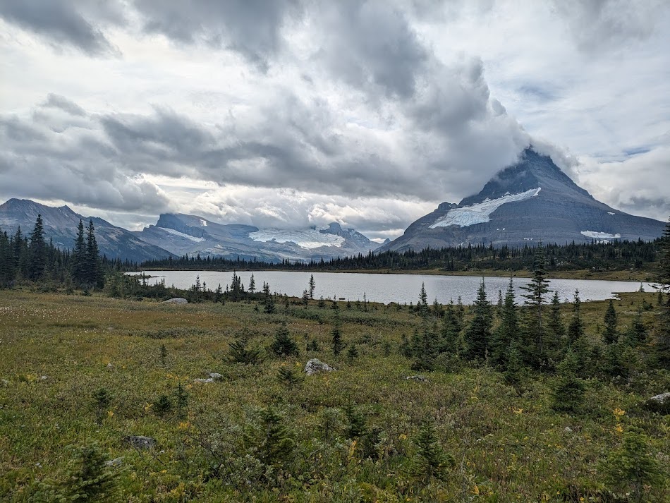
The Great Divide Route follows the divide between Kakwa Lake (where the GDT terminates) to Monkman Provincial Park in northern BC. The route is almost entirely off trail and travels through beautiful, remote wilderness. Only a few parties attempt the route every year, and it is not to be underestimated. Hikers considering the GDR should study the challenges listed on this page carefully to ensure they have the skills to complete the route without requiring rescue. It is also highly recommended to reach out to hikers who have already completed the route for a full understanding of the difficulties.
Challenges
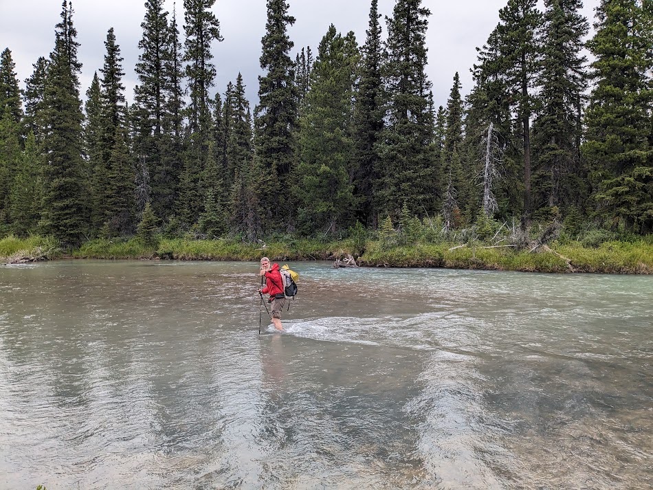
If you can think of a hiking danger, it exists on the GDR. The route is significantly more challenging than the GDT and the GDR is even more remote, meaning help may be days away. Weather is often extreme, and snow is possible even in mid-summer. The route is prime grizzly bear habitat, and bears encountered may not be used to dealing with people. River crossings are significant, and may even require swimming in bad years. The terrain itself is a constant challenge (outlined in more detail below) and hikers will need solid navigation skills. Wildfire is also a significant concern, and due to the remoteness of the route and the time required to complete it, hikers may not be aware of fires in the area.
Hikers may find the route slower to complete than expected, and it is a good idea to have a buffer in case of bad weather or other delays. It is therefore recommended that hikers carry several days of extra food on the GDR.
The GDT’s Backcountry Safety page is a good start for hikers wishing to learn more about potential danger. However, please keep in mind that this page is designed for the GDT, and that the GDR challenges are even more extreme.
Terrain
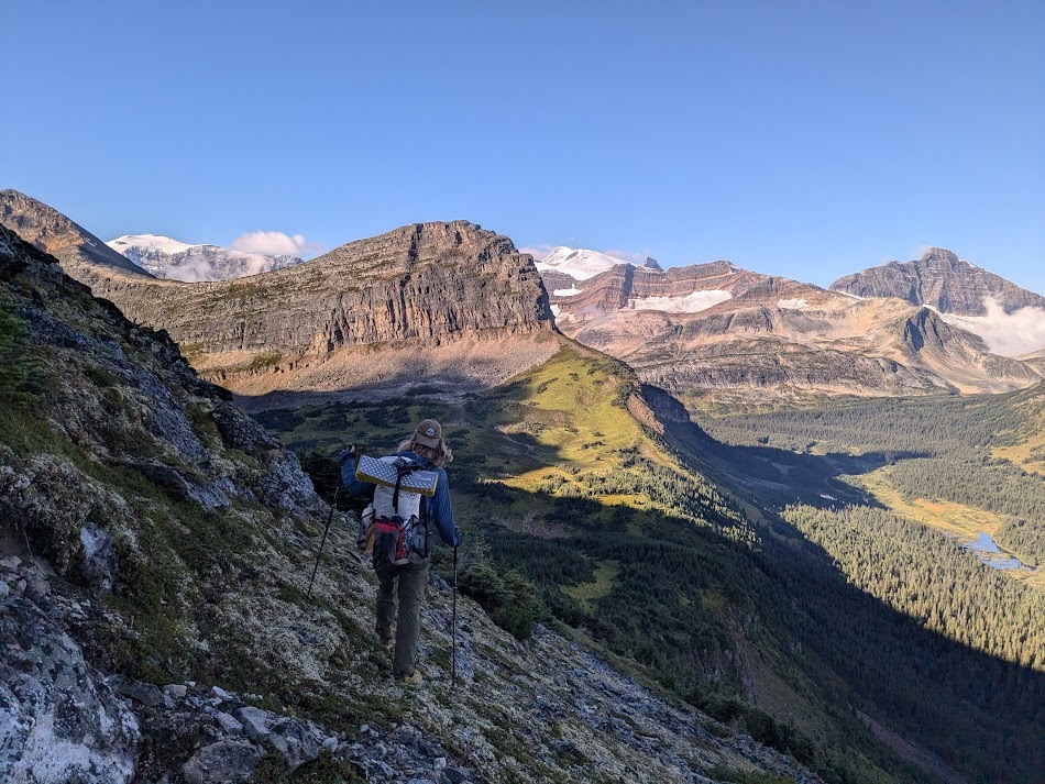
Trail exists between Kakwa Lake and the Jarvis Lake Cabin, and then for the last 27km from just above Monkman lake to the Monkman Lake trailhead. The trail between Kakwa and Jarvis can be rough, and is mostly unmaintained. Apart from these short sections, the entire route is off trail, and features everything from alpine walking to bushwhacking through thick willow. Hikers should be prepared for challenging river crossings, short scrambles, steep descents, and of course, endless bushwhacking. Much of the route below the treeline follows damp meadows to minimize bushwhacking, and hikers can expect wet feet for the majority of their trip.
There are no trail markings or navigation aids between Jarvis and Monkman lake, and hikers should be expert navigators. Due to the limited number of people who have attempted the route, hikers should also be prepared to make their own route decisions, as the current GPX track may not be the “best” route and conditions change quickly. Hikers should especially be prepared to make smart route decisions around the Narraway river, as gravel bars providing crossing spots shift, and the “safe” place to cross found by previous groups may no longer be a good option.
Access
There are three access points to the route- at Kakwa Lake (which can be accessed from either the BC side via Walker FSR or from the Alberta side via Lick Creek), at a remote ATV track at Warner Lake roughly halfway through the route, and at Monkman Lake. Hikers can also access the route via helicopter outside of the provincial parks.
Limited access points mean that bailing from the GDR can be a challenge. Hikers should be prepared to backtrack for several days if needed.
Leave No Trace
Most of the route is pristine wilderness. There are very few signs of humans or past human activities. You will encounter no fire rings, established campsites, cairns, flagging, or trash. Please help keep it this way, leave the route better than you found it, and practice impeccable leave no trace ethics. Untouched wilderness is one of the main reasons to hike this route – please ensure that future hikers can also experience multiple days without signs of people.
Suggested Itineraries
Suggested itineraries do not currently exist for the GDR. Apart from a small spot at Warner Lake, there are no established campsites between Jarvis Lake and Monkman Lake, and hikers should be prepared to find their own spots while practicing good Leave No Trace Principles. A solid understanding of how many miles a day you personally can hike off trail is needed to determine how long the GDR will take you. Hard-core thru-hikers with remote Canadian Rockies experience have completed the route in as few as 7 days. A plan for between 10 and 15 days with supplies for a few more in case of weather would be more reasonable and prudent. The GDR was recently hiked in 11 days by a pair of hikers who had comfortably followed the GDT’s average itinerary.
Planning your hike
While the GDTA continues development of our multi-year, multi-phase strategy to guide our involvement with the GDR, hikers can find more information to facilitate their planning on this volunteer’s website: https://sites.google.com/view/hikingthegreatdivideroute