

Find out the latest on the conditions out on the trail.
Trail conditions and closures are monitored by the GDTA but much of this information is crowd-sourced and depends on trail user contributions. Please report trail conditions via email.
July 13, 2026
Significant rain and flooding in the southern Rockies earlier this month caused localized trail and road damage. While access has been restored to many areas, some trails and campground closures remain in effect (see below). Crews are conducting detailed assessments of trails, campgrounds, roads and other infrastructure impacted by flooding and high water. Please stay off closed trails and out of restricted areas to protect your safety, allow crews to complete their work, and help prevent further damage to already vulnerable landscapes and infrastructure.
Trails are mostly bare or muddy, while some snow patches remain at higher elevation particular on the north aspects of passes. Some trails have not been maintained since last season and trail repairs for damage caused by the recent weather event will take additional time. Be prepared for variable conditions.
Trail Closures and Notices
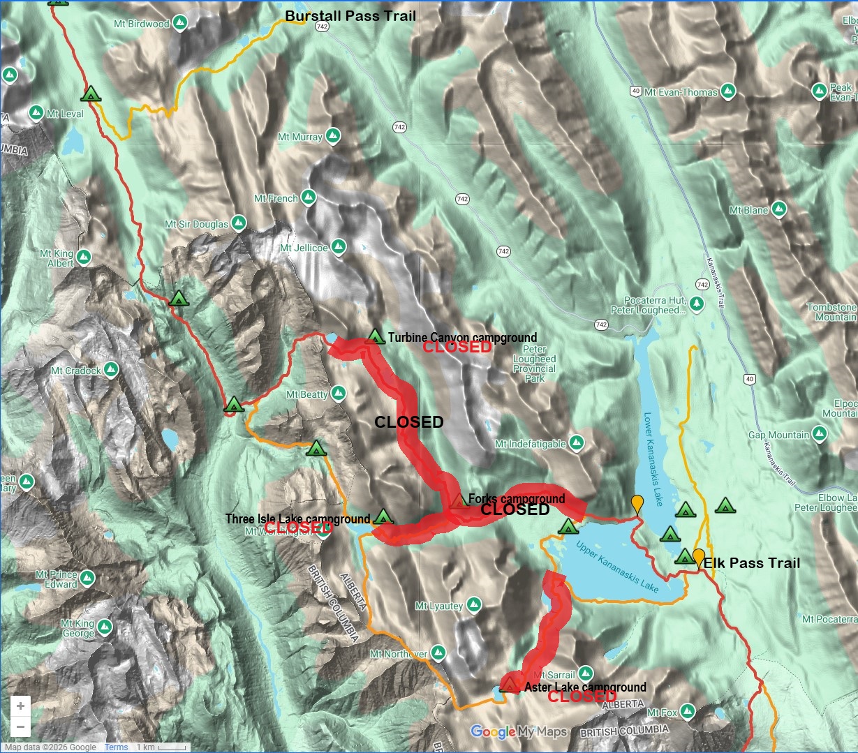
- TRAIL CLOSURES: The following trails in Peter Lougheed Provincial Park are closed until further notice due to flood damage: Maude-Lawson Trail (from Forks campground to North Kananaskis Pass), Three Isle Lake Trail (beyond Point campground to South Kananaskis Pass) and the Aster Lake Trail (Northover Ridge access). These closures mean there is no contiguous hiking route through Peter Lougheed Provincial Park. DETOUR: Hikers can exit or connect with the GDT via Burstall Pass Trail (to the north of the closure) and Elk Pass Trail (to the south of the closure).
- CAMPGROUND CLOSURES: The following backcountry campgrounds in Peter Lougheed Provincial Park are closed until further notice due to flood damage: Aster Lake, Forks, Three Isle Lake, and Turbine Canyon. Crews are actively investigating damage and undertaking repairs where necessary. Backcountry campgrounds will be reopened as conditions allow. Impacted reservations will be cancelled and refunded.
- CREEKS: Rainfall and rapid snow melt have resulted in very high water levels, some damaged or washed out bridges, and potentially dangerous creek crossings. Hikers should use extreme caution around waterways, obey all posted signs, barricades and closures. If possible, attempt to ford larger creeks early in the day when water levels are lowest.
- NOTICE: The new permanent Blaeberry River Cable Car at the northern end of the Collie Creek Alternate Route is now fully operational. It can handle 1 or 2 people plus gear at a time, but the effort required is less if one person rides and one person pulls the hand line from the loading platform. If two people are riding at the same time, sit or kneel on opposite sides of the rope so the cart stays vertical, which reduces friction between the cable car and the wheels. The Collie Creek Alternate Route is open and is the recommended route given the Cairnes Creek bridge has washed out.
- CAUTION: Cairnes Creek bridge was damaged over the winter and washed away this spring. Hikers should be prepared to ford the creek, ideally early in the morning when the water level is the lowest.
- CLOSURE – Kootenay National Park: Numa Creek Access Trail from Numa Creek campground to Numa Falls bridge is closed due to bridge washout and debris on trail.
- BEARS: Bears are out and about, actively searching for food and focused on feeding. Be bear aware on the trails this summer, make noise and carry bear spray.
- WARNING – Waterton Lakes National Park: A bear has approached people and has shown interest in human food in the area between Waterton townsite and Canada-US border. Bertha Lake campground is closed but Bertha Bay campground and Boundary Bay campground remain open. Extra caution is advised.
- WARNING – Waterton Lakes National Park: An aggressive grizzly bear charged a large group of people on the Rowe Lakes Trail. Extra caution is advised.
- FIRE: Currently there are no fire bans along the GDT but fire risk is rising with warmer, drier weather. Smoke from wildfires is having a low impact on air quality in the southern Canadian Rockies but can deteriorate with changing wind patterns. If you must have a campfire in the backcountry, please ensure you follow the rules.
Access
- Highway 742 / Spray Lakes Road is closed between Grassi Lakes parking area and Goat Creek, southwest of Canmore due to a rockslide. No public access for any type of vehicle or on foot.
- Highway 40 is open to one lane alternating traffic at the Evan-Thomas Bridge, south of Kananaskis Village. Campers are able to access frontcountry campgrounds in Kananaskis but expect delays due to ongoing repairs.
- A Kananaskis Conservation Pass is required for all vehicles visiting Kananaskis Country and provincial sites in the Bow Valley Corridor. The pass is not required for people arriving without a vehicle on foot, horseback or bicycle.
- Due to recent maintenance, BC Parks lists Walker Creek FSR in good condition up to km 50 but beyond that point it is still overgrown and in very rough shape. The road should remain open and accessible for those with high clearance 4WD vehicles willing to drive the rough and overgrown road all the way to the Bastille Creek trailhead.
- For more information, check out Alberta 511 and Drive BC.
National and Provincial Park Trail Conditions:
Banff National Park
Jasper National Park – Submit a Jasper trail condition report
Kootenay National Park
Waterton Lakes National Park
Yoho National Park
Akamina‐Kishinena Provincial Park
Castle Wildland Provincial Park
Castle Provincial Park
Elk Lakes Provincial Park
Height of the Rockies Provincial Park
Kakwa Provincial Park
Mount Assiniboine Provincial Park
Mount Robson Provincial Park
Peter Lougheed Provincial Park