

Section G: Mount Robson to Kakwa Lake
| Suggested start/finish | Blueberry Lake to Kakwa Lake (while Mt. Robson access is closed) |
| Recommended number of days for section | 8 (relaxed), 5 (average), 4 (fast). Note: this does not include additional days to exit from Kakwa |
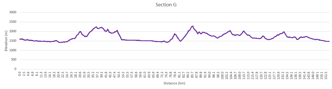
| Distance | 154 km |
| Elevation Gain/Loss | 8696m / -8816m |
| Traditional Territory of the | Stoney Nakoda, Cree, Lheidli T’enneh, Secwépemc, and Métis |
| National Parks | Jasper National Park |
| Permits required | Parks Canada Discovery Pass and backcountry camping permits in Jasper National Park, Alberta Crown Land Camping Pass |

Several sections of the trail vie for the moniker “Heart of the GDT”: Section B contains the first dedicated sections of trail (and where a lot of current work is being done); Section C passes through some of the most spectacular scenery in the Rockies, but it is also the most popular and crowded; parts of Section E spend mile after wondrous mile in the high alpine. However, it is Section G where you truly encounter the rugged, remote wilderness that the GDT is known for. Once you leave Highway 16 past the Jasper townsite, you won’t cross another road until you finish the trail. Here trails are infrequently maintained, bridge crossings are few, deadfall is plentiful and bail out options are limited, but you will be rewarded by some of the most spectacular hiking on the Great Divide. Be prepared for up to 10-day (or longer) food carries.
The North Boundary Trail
Continuing on the main route of the GDT, we move from Section F to Section G and the remote (and soggy) Smoky River valley. At Chown Creek and Bess Pass you’ll be following parts of the Jasper North Boundary Trail. This can be hiked as a separate 115 mile (185 km) thru-hike taking you through the remote northern sections of Jasper National Park. From this point on, you may encounter horses on the trail so make sure to brush up on your etiquette.
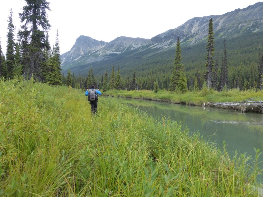
Leaving the North Boundary Trail you’ll cross into the Jackpine Valley and the first of several similar decisions you’ll make from here on in. At many points the trail splits between a high route and a low route. The high routes typically take you above the treeline, giving you incredible views of remote peaks, glaciers and valleys. On the flip side, these high routes are exposed to lightning, and often involve route finding (no trails) and some easy to moderate scrambling. If conditions are good, most folks recommend taking the high routes. If weather is poor, you may have to constrain yourselves to the muddier, brushier valleys.
Campgrounds in this area:
- Wolverine North (often flooded into late August) – Jasper National Park (permit and reservation required)
- Timothy Slides – Jasper National Park (permit and reservation required)
- Chown Creek – Jasper National Park (permit and reservation required)
- Jackpine Pass – Random Camping (no permits required)
Entry / Exit Points
- South – Highway 16 via Berg Lake Trail (currently closed)
- North – Highway 16 via Holmes River Road and Blueberry Trail
Resupply
- Resupply lockers at the Blueberry Trailhead
Taking the High or Low Road
For the Jackpine, the main trail takes you across a ridge line with a lower alternate trail in the valley. Work has recently been done to clear the trail in this area, so you can expect significantly improved trail conditions thanks to GDTA volunteers! You can exit the trail at Holmes River, but this is a 25 mile (43 km) unmaintained route back to Highway 16. At Jackpine Mountain, you can again choose to stay in the alpine along the Perseverance and Loren Lake High Routes or climb down to the Jackpine River.
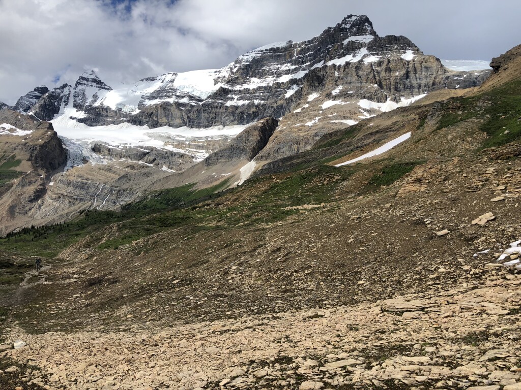
The routes rejoin each other at Big Shale Hill and closely parallel the Great Divide for several miles with an optional side trip to the summit of Mount Talbot. Staying up high, the trail heads over Morkill and Fetherstonhaugh Passes.
Back down into Casket Creek valley, you’ll find a junction with the Sheep River trail and an exit to Grande Cache in Alberta. This 45 mile (72 km) trail through the Wilmore Wilderness has a few significant fords, but ends in town and full services.
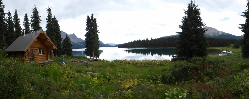
Passing into BC and Kakwa Provincial Park, the next two alternates are the Surprise Pass and Providence Pass high routes. If conditions allow, again, taking these high routes are preferred as you can enjoy beautiful views of Cecilia Lake. The two trails meet up again at Kakwa Lake campground and cabin, and the official northern terminus of the GDT.
Campgrounds in this area:
- Jackpine River – Random Camping (Alberta crown land camping pass required)
- Pauline Creek – Random Camping (Alberta crown land camping pass required)
- Shale Pass – Random Camping (no permits required)
- Morkill Pass – Random Camping (no permits required)
- Casket Pass – Random Camping (Alberta crown land camping pass required)
- Copper Kettle – Random Camping (Alberta crown land camping pass required)
- Broadview Lake – BC Parks Random camping (no permits required)
- Kakwa Lake – BC Parks Random camping (no permits required)
- Kakwa Lake Cabin – BC Parks (first come first served)
Entry / Exit Points
- South – Highway 16 via Holmes River Road and Blueberry Trail
- Mid – Grande Cache (Alberta Highway 40) via Sheep River Trail
- North – None
Resupply
- None
Not Quite Done Yet
This isn’t the end though. From Kakwa Lake it’s a 30 km walk to the Bastille Creek Trailhead which is the closest you can get by vehicle (and on a rough forestry road at that). Down the road, it’s 74 km (46 miles) to Highway 16. While some have managed to grab a hitch along the forestry road, others have had to walk all the way to the main highway. From there you’ll need to get a ride west Prince George (the closest airport to the trail) or east towards Valemount or Jasper. BC Forestry occasionally makes repairs to this road, so look for updates before heading in.
Hikers may also choose to exit to the east of Kakwa. It’s 48 km down old tote roads (often marshy) and OHV tracks to Lick Creek trailhead. This may make more sense for hikers who wish to head to Grande Prairie after their hike, or during times when BC Forestry has closed Walker FSR.
Campgrounds in this area:
- Buchanan Creek – Random camping (no permits required)
Entry / Exit Points
- South – None
- North (west) – Highway 16
- North (east) – Lick Creek trailhead
Resupply
- You’re still here? It’s over, go home! Either that or turn around and start back south…


