

| Suggested start/finish | Atlas Staging Area to Dutch Creek Bridge |
| Recommended number of days for section | 4 (relaxed), 3 (average), 2 (fast) |
| Distance | 50 km |
| Elevation Gain/Loss | 3977m / -4458m |
| National Parks | None |
| Permits required | Alberta Backcountry Camping Permit |
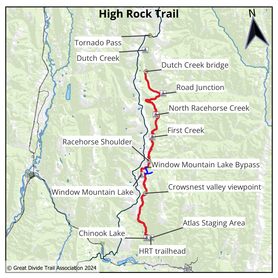
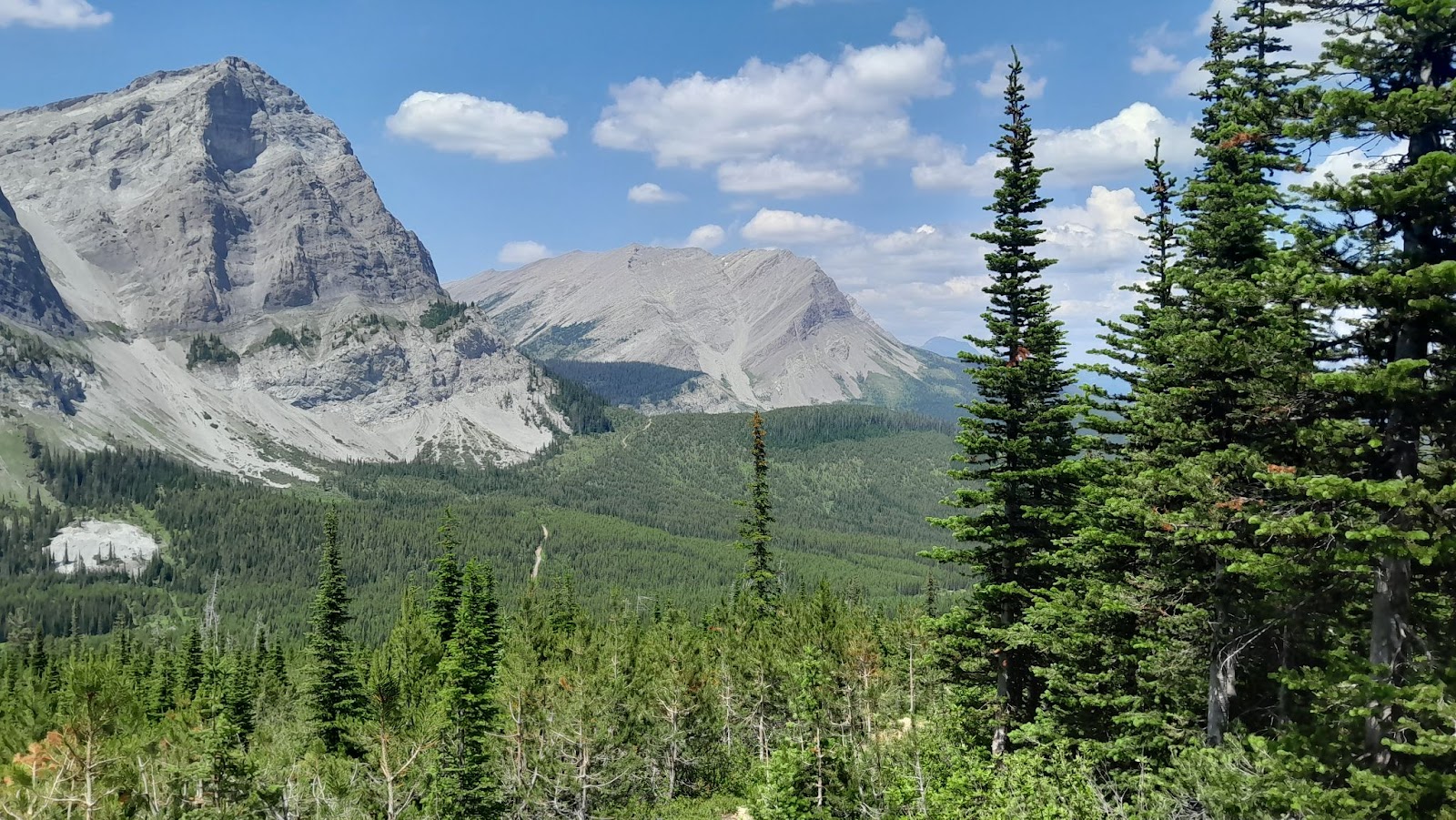
The High Rock Trail (HRT) is the perfect introduction to the Great Divide Trail. Just north of Coleman, Alberta, the HRT runs 50 km from the Atlas Staging Area to Dutch Creek Bridge. The trail hugs the High Rock range close to the divide, and hikers will enjoy stunning views of steep rock walls, pretty alpine meadows, and a campsite by beautiful Window Mountain Lake. Hikers can complete this short section in anything from two to five days, and easy road access makes it a breeze to shuttle cars to either end of the hike. The only permit required is the Alberta Public Lands Camping Pass, so hikers can enjoy this section without booking campsites months in advance.
History
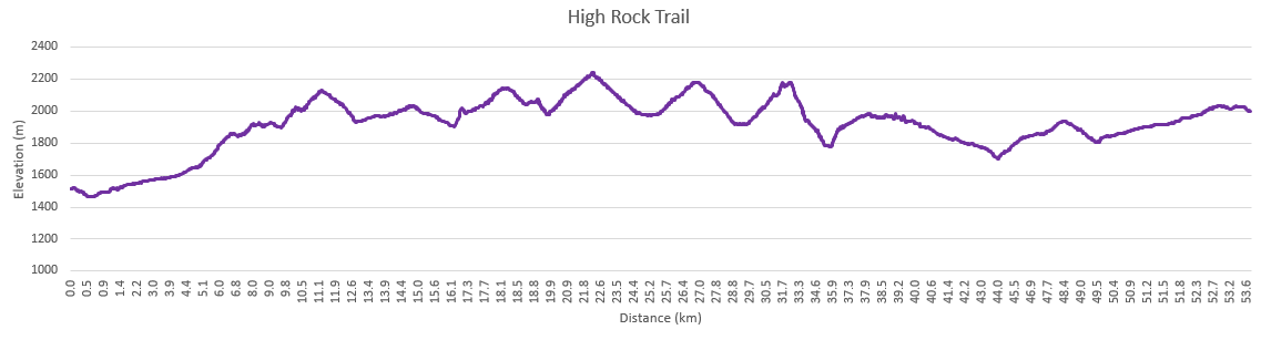
Construction on the HRT began in 2016. Previously, the GDT followed OHV roads on the western side of the High Rock Range. Hundreds of volunteers helped create the trail, build bridges and blaze a new route closer to the divide. The HRT officially opened in 2022. However, the trail is still evolving as the GDT works to create new singletrack and move the trail away from OHV tracks. Hikers are likely to see trail crews, and may find brand new sections of trail that differ from their maps or the descriptions below. In 2024, the GDTA plans to reroute the trail north of Fred Creek Bridge to include new alpine lakes and move the trail away from old, swampy roads.
Terrain
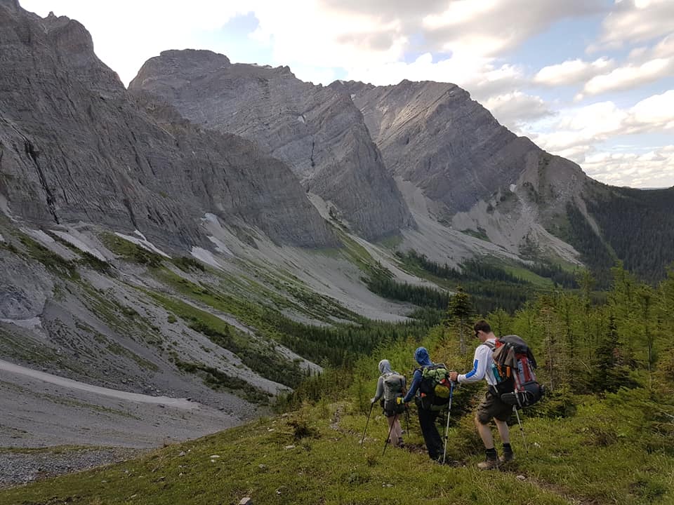
The HRT is better constructed, blazed, and more maintained than many other sections of the GDT. Hikers can expect switchbacks, clear trail signs, and fewer blowdowns than on other sections. Most streams on the HRT are bridged (with bridges planned for the few river fords remaining). This makes the HRT the perfect place for hikers new to the GDT to experience the divide.
While the trail quality is much better than many other GDT sections, hikers should still be prepared for a decent amount of elevation change. The HRT dips into each drainage before climbing back up to cross ridges descending from the main High Rock Range. Hikers should also be prepared for challenges that are present all along the divide and should be familiar with backcountry safety.
Access
Atlas Staging Area is a busy campground and parking area. While the staging area is up a dirt road, it is easily accessible by almost any vehicle – no high clearance or four wheel drive required.
The Dutch Creek HRT campground at kilometre 199.3 (not Dutch Creek-Tornado Pass campground, which is further up the trail) is next to the dirt road that leads back to the Atlas Staging Area. The road is still accessible, although vehicles with four wheel drive or high clearance may be more comfortable driving on it. This would be a great place to leave a car for hikers with access to two vehicles. It would also be a good place to leave a bicycle for hikers with a single car who would like to set up a bike shuttle.
The dirt road running between Atlas Staging Area and Dutch Creek is known as the Atlas Road, running north-south to the east of the HRT. Almost every OHV road that crosses the HRT leads back to the Atlas Road. Hikers who wish to cut their trip short, or to hike a shorter section can easily cut down to the road and return to their vehicle.
Suggested Itineraries
Two Day Itinerary
This two day itinerary will be challenging even for thru-hikers and includes a decent amount of elevation gain. Hikers should stop at Dutch Creek rather than continuing on to Dutch Creek Campground to allow for easy return to their vehicle. If you’d prefer to continue on to Dutch Creek Campground, add a full day to your itinerary as this additional section is 9.8 km one way.
Day one: Atlas Staging Area (FarOut km 154.9) to Window Mountain Lake (FarOut km 172.3). Total distance: 17.4 km.
Day two: Window Mountain Lake (FarOut km 172.3) to Dutch Creek (FarOut km 199.3). Total distance: 27 km.
Three Day Itinerary
A more relaxed version of the two day itinerary for those who don’t want to rush. Add an extra day if you wish to continue on to Dutch Creek Campground and backtrack to your vehicle (9.8 km one way).
Day one: Atlas Staging Area (FarOut km 154.9) to Window Mountain Lake (FarOut km 172.3). Total distance: 17.4 km.
Day two: Window Mountain Lake (FarOut km 172.3) to First Creek Campground (FarOut km 184.2) Total distance: 11.9 km
Day three: First Creek Campground (FarOut km 184.2) to Dutch Creek (FarOut km 199.3) Total distance: 15.1 km
Four Day Itinerary
The ultimate way to explore the HRT while having plenty of time to detour, swim in lakes, or climb nearby peaks. Add one or two days to continue to Dutch Creek Campground and backtrack to your vehicle (9.8 km one way).
Day one: Atlas Staging Area (FarOut km 154.9) to Crowsnest Valley Viewpoint random camp (FarOut km 166.6) Note: there is no water at Crowsnest Valley viewpoint- grab some from the seasonal stream as you begin the climb. Total Distance: 11.7 km
Day two: Crowsnest Valley viewpoint (FarOut km 166.6) to Window Mountain Lake (FarOut km 172.3). Note: this is the perfect day to add a side trip to the peaks around Window Mountain Lake, or to enjoy lounging on the lake shore. Total Distance: 5.7 km
Day three: Window Mountain Lake (FarOut km 172.3) to First Creek Campground (FarOut km 184.2) Total distance: 11.9 km
Day four: First Creek Campground (FarOut km 184.2) to Dutch Creek (FarOut km 199.3) Total distance: 15.1 km
High Rock Trail (HRT) NOBO Description
The High Rock Trail is easily reached from the Atlas Road. From the Atlas Staging Area (b4), look for the HRT trailhead at the south end of the staging area on the west side of the road. Heading off on the trail, follow switchbacks down to the new Allison Creek bridge. Fill up with water here, as the next reliable source isn’t until Window Mountain Lake in 16 km. Across the bridge, the HRT climbs to the east but for a refreshing swim on a hot day, head west 1 km to Chinook Lake!
Continuing north, the trail crosses Deadman Pass road – the former route of the GDT prior to the construction of the HRT – as it climbs the forested slopes of the Divide. Follow the trail for 800 metres where you will turn right onto an old ATV track. The track gains 100m over 1 km before a short but steep climb marks the end of the ATV track and the return to single-track trail at 1740m.
The trail climbs steadily to reach treeline at 1820m. The trail remains above treeline with spectacular views of Crowsnest Mountain to the east, contouring between 1840m and 1920m for the next 3 km. The trail intersects with an ATV track before dipping back into the forest, continuing north. The trail stays in the forest for half kilometre before reaching treeline again at the beginning of a short steep climb up a talus slope. The trail stays just above treeline as the gradient eases off at 2000m. Continue for 1 km, contouring above treeline and up a set of switchbacks through sparse trees to a forested ridge crest. Follow the forested ridgeline to a high point at 2100m (b6) with incredible views of the Crowsnest valley, until the trail veers away from the ridge dropping into the forest. The trail then enters an old cutblock where it will mostly remain for the next few kilometres. There is regrowth in the old cutblock but still many outstanding views of the impressive headwall of the Great Divide.
The trail gently descends through the old cutblock, losing 150m elevation over the next 1.5 km. You will cross a couple ATV tracks as the trail parallels the base of the headwall. A short steep climb will bring you to the western edge of the cutblock at 2020m. Single-track trail continues through old cutblocks and adjacent forest until reaching the Window Mountain Lake trailhead and junction with the WML Bypass Trail. Note that horses are not able to access Window Mountain Lake but can take the Bypass Trail to continue north on the HRT.

Follow the Window Mountain Lake trail, very steep in sections, to reach Window Mountain Lake campground (b7) on the shores of the beautiful lake. The HRT continues through the campground heading up the sparsely treed slopes on the north end of the lake. The trail climbs well graded switchbacks up to the top of the ridge surrounding the lake, reaching a high point at 2120m. On the north side of the ridge, you will see the road descending from Racehorse Pass below you. Follow the edge of the forest where it meets the talus slope on your right, descending steeply to the reach the road.
Follow Racehorse Pass Road east to a marked junction where the trail leaves the road and begins climbing the open slope. Follow the trail as it climbs steep switchbacks to reach Racehorse Shoulder at 2255m (b8), the highest point on the entire HRT with impressive views in all directions. The trail has an alpine feel as it descends the north side of the ridge at the edge of a lovely larch forest, and in 2.5 km reaches a junction with an ATV road in an alpine basin at 1980m. An emergency shelter is located 3.5 km east down this road.
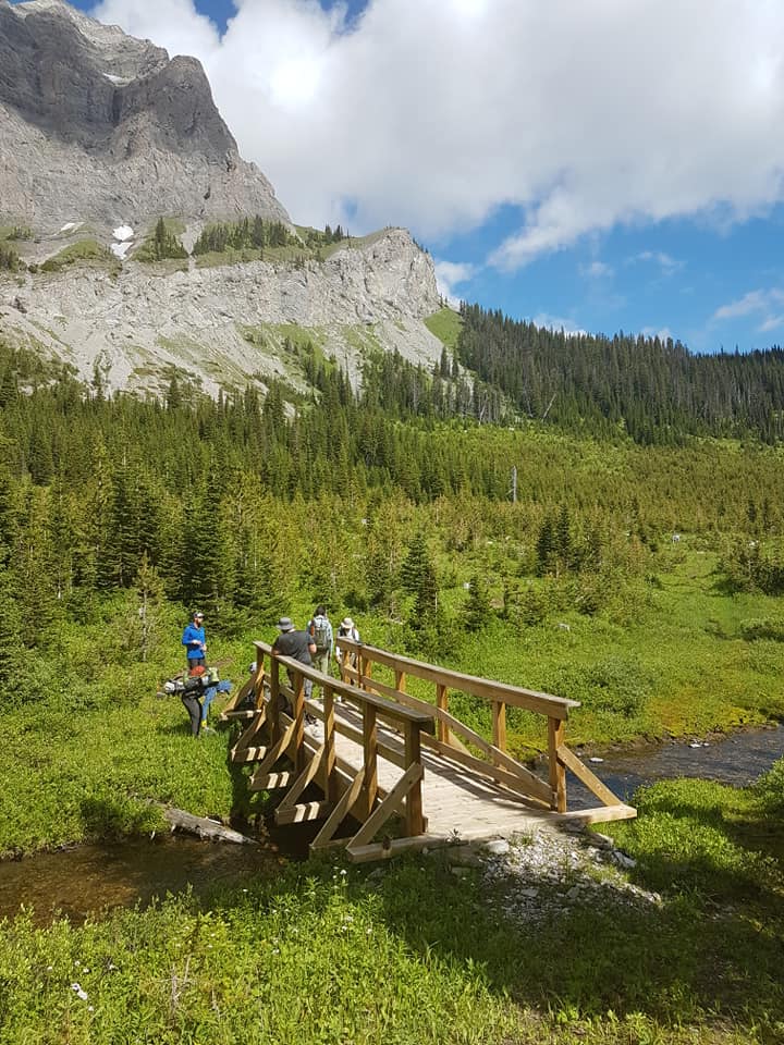
The trail continues across the basin and into the forest before starting a steep climb, ascending several switchbacks to the saddle between Hail Ridge and the main divide at 2165m. Descend more gently on the north side of the saddle, down to an old road at 2000m in an old cutblock in the open basin below the huge headwall of the divide. Follow the old road as it curves northward to reach a signed trail junction (b9). First Creek campground is 200 metres off route to the right (northeast). The HRT follows the trail left (northwest), across the First Creek Bridge, as it ascends along the eastern edge of an old cutblock until the trail enters the forest at 1980m. The trail climbs steadily to reach the saddle at 2060m. A rest stop with an excellent viewpoint lies slightly off route, 100 metres west of the saddle.
The trail continues northeast, contouring around the east side of Domke Ridge, reaching a high point of 2185m (b10). Follow the ridge crest through lovely larch forest before descending gradually to 2045m at a point where the trail drops sharply off the east side of the ridge into the forest. Descend a series of switchbacks to a junction with an ATV road at 1815m. Follow the ATV road west to a ford of North Racehorse Creek (b11). Good camping exists on a flat bench on the north side of the creek.
Leaving the creek, stay left at a junction and follow the ATV road briefly to a signed single-track trail leaving the road to enter the forest. Follow the trail as it climbs gradually through thick forest before levelling out around 1990m. The trail contours between 1980m and 2020m with good views of Gould Dome and Tornado Mountain to the north.
The trail then descends 100m to reach an old ATV track which it follows to a junction. Stay left (north) at the junction and descend slightly to cross Fred Bridge. Continue following an ATV road northeast to a junction with an old logging road at 1715m (b12). The Dutch Creek HRT Campground is 200 metres down the road to the right.