

Coleman to Kananaskis
| Suggested start/finish | Coleman and Elk Pass Trailhead |
| Recommended number of days for section | 11 (relaxed), 8 (average), 5 (fast) |
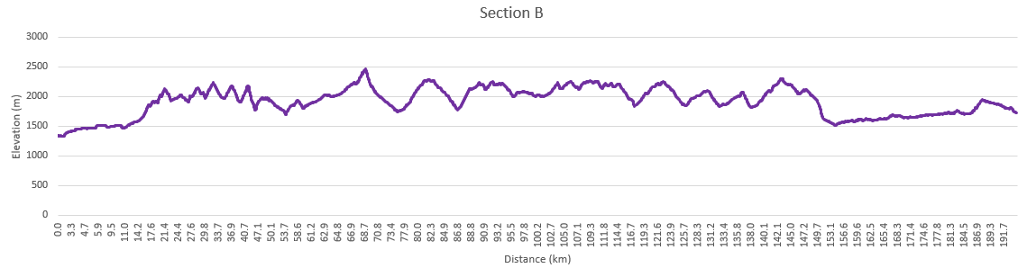
| Distance | 195 km |
| Elevation Gain/Loss | 13597m / -13214m |
| Traditional Territory of the | Blackfoot Confederacy, Tsuut’ina, Stoney Nakoda, Ktunaxa, Secwépemc, and Métis |
| National Parks | |
| Permits required | Alberta Public Lands Camping Pass |
| Alternates | Coral Pass |

Section B of the GDT runs north from the town of Coleman on Crowsnest Highway 3 to Peter Lougheed Provincial Park in Kananaskis, Alberta. This part of the trail runs almost entirely through public land and has little in the way of developed campgrounds or facilities. Except for a small portion in the north, random camping is allowed throughout this section. You may encounter OHV users and, in some cases, active forestry operations along the trail. If you do encounter active logging, keep an eye out and respect any signage.
In some ways, Section B is the birthplace of the GDT. In the 1970s the first portions of dedicated trail were constructed here and work continues to this day with the new High Rock Trail completed in 2021.
Road and Off-Highway Vehicle Trails
The first part of the trail is largely made up of gravel roads and OHV trails. During the summer (particularly on weekends) you’ll encounter folks camping in their RVs along the Allison Creek and Atlas roads. Parts of this trail can be confusing as there are many junctions connecting a nest of old forestry roads. Once the GDT joins the High Rock Trail, the route is well marked.
Crowsnest Mountain figures prominently to the east as you may your way up the valley. Until recently the trail continued over Deadman Pass into BC, but with parts of the trail crossing private land, the High Rock Trail was built to avoid conflict with industrial users and the Line Creek coal mine.
Campgrounds in this area:
- McGillivray Creek – ATV staging area (Alberta Public Lands Camping Pass required)
- Chinook Lake – Alberta Parks (Reservation recommended and permit required)
- Atlas Staging Area – ATV staging area (Alberta Public Lands Camping Pass required)
Entry / Exit Points
- South – Highway 3
- North – Atlas Forestry Road
Resupply
- Coleman
- Blairmore (off trail)
The High Rock Trail
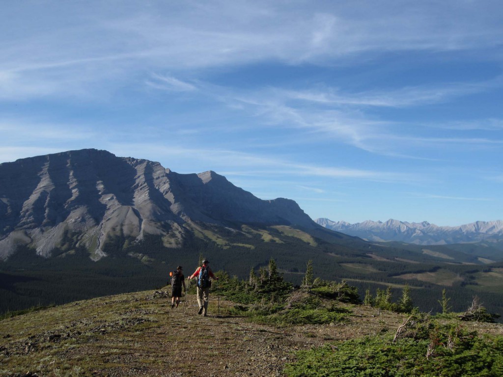
2022 marked the grand opening of the High Rock Trail and the new official route of the GDT. You can learn more about the High Rock Trail on our dedicated web page. Many will stay at the beautiful Window Mountain Lake for the first night as bear lockers have been recently installed. This section mainly sticks to the Livingstone Public Land Use Zone which allows a wide variety of users. You’ll gain and lose elevation as you move from one drainage to another, first North Racehorse Creek then Dutch Creek. At the headwaters you’ll encounter the old route from the BC side as you climb up to Tornado Pass, through Tornado Saddle and steeply down the other side.
Campgrounds in this area:
- Window Mountain Lake – Random camping (Alberta Public Lands Camping Pass required)
- North Racehorse Creek – Random camping (Alberta Public Lands Camping Pass required)
- Dutch Creek – HRT – Random camping (Alberta Public Lands Camping Pass required)
- Dutch Creek – Tornado Pass – Random camping (Alberta Public Lands Camping Pass required)
- South Hidden Creek – Random camping (Alberta Public Lands Camping Pass required)
Entry / Exit Points
- South – Atlas Forestry Road
- North – Alberta Highway 940 (Via Oldman River Road and Hidden Creek Trail)
Resupply
- None
Birthplace of the Great Divide Trail
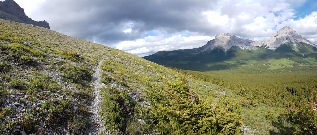
At North Fork Pass, you’ll join the original GDT and a junction with Dutch Creek Road. This road serves as the first of many access/exit point to Highway 940 on the Alberta side. While this road can be busy in on weekends, it can be fairly quiet on weekdays, so if you have to bail it could be quite a while before you get a hitch. Following the orange blazes, the trail closely parallels the divide with additional access points at Hidden Creek, Cache Creek, Soda Creek, Oldman River, Lost Creek, Cataract Creek, Etherington Creek, and Baril Creek. While you don’t see as many of the epic mountain spires as Section C, the scenery is still spectacular, particularly in and around the Beehive Natural Area. You’ll experience a lot of ups and down in this part with some nice ridge walks. Rustic camping areas are located near many of the creek junctions. While the idea of camping on the top of a ridge can be appealing, a sleepless night as your fly flutters in the wind isn’t nearly as much fun as you might think.
At Baril Creek the trail heads to the west and climbs up to Fording River Pass, crossing the Great Divide for the first time since La Coulotte Peak over 130 km to the south.
Campgrounds in this area:
- Hidden Creek – Random camping (Alberta Public Lands Camping Pass required)
- Cache Creek – Random camping (no permit required)
- Soda Creek – Random camping (no permit required)
- Lyall Creek – Random camping (no permit required)
- Memory Lake – Random camping (no permit required)
- High Rock – Random camping (no permit required)
- Lost Creek – Random camping (no permit required)
- Cataract Creek – Random camping (no permit required)
- Etherington Creek – Random camping (no permit required)
- James Lake– Random camping (no permit required)
- Upper Baril Creek– Random camping (no permit required)
- Fording River Pass – Random camping (no permit required)
Entry / Exit Points
- South – Alberta Highway 940 (Via Oldman River Road and Hidden Creek Trail)
- North – Elk River Road
Resupply
- Highwood House (13 km off trail at Baril Creek, limited options)
Elk Valley to Peter Lougheed Provincial Park
Coming down Aldridge Creek you’ll meet up with the Kananaskis Power Line Road which connects to Elk Lakes Road in about 8 km. This is the longest road walk on the GDT, but it is a lightly trafficked, well-maintained gravel/dirt road, and quite scenic. There is a washout on the Aldridge Creek trail and the easiest way past it is to get your feet wet. Elevation gains on this section are minimal, so if you’re looking for a high mileage day, this is it. There are a few user maintained forestry campgrounds along the Elk River Road that offer outhouses and picnic tables.
If you’re a confident route-finder, you can avoid some of this road walk by taking the Coral Pass Alternate. There is an initial ford of the Elk River, which can be challenging in high water conditions. The pass is incredible and earns its name with plentiful fossilized coral, however, descending the north side involves some exposure, slippery rocks, and can be extremely overgrown. If weather is poor, the recommendation is to stick to the road.
Either way, you’ll soon come to Elk Lakes Provincial Park. From here on in, apart from a small part of Section D, you’ll be on protected lands, leaving OHVs behind for the rest of the trail.
Near the Elk Lakes trailhead, there is a cabin currently operated by the Alpine Club of Canada and a nearby campground. From here there are a few options. First is the Hydroline Trail (popular with mountain bikers), which is a straight shot up to Elk Pass along a set of power lines. There is also Elkan Creek, which takes you through forest to West Elk Pass; it is shorter, but obscures most of the views. Lastly, there is the official Upper Elk Lake Trail, which offers nice views of the Elk Valley. At Elk Pass you will cross back into Alberta and follow Fox Creek to the trailhead at the end of Section B. The GDTA manages resupply lockers at the Elk Pass trailhead to allow resupply boxes to be deposited and stored for hikers.

Coming into Peter Lougheed Provincial Park, random camping is no longer permitted, but there are plenty of options. A full-service campground including showers, store, and ice cream are available a few minutes away at Boulton Creek, there is a tent-only campground at Mt. Sarrail, and a third nearby campground at Interlakes. Boulton is popular with thru-hikers as you can book sites with electricity to charge all your devices. It is often booked solid on weekends, but weekdays usually have availability.
The end of Section B is a good place to build a zero day into your itinerary. With Section C very dependent on permits and keeping to your schedule, this will give you the flexibility to catch up if you’re running behind, or some time to enjoy the area otherwise.
Campgrounds in this area:
- Aldridge Creek – BC Forestry (first come first served)
- Weary Creek – BC Forestry (first come first served)
- Riverside – BC Forestry (first come first served)
- Tobermory Creek – BC Forestry (first come first served)
- Lower Elk Lake – Elk Lakes Provincial Park (permit required)
- Elk Lakes ACC Hut – Elk Lakes Provincial Park (book through Alpine Club of Canada)
- Boulton Creek – Peter Lougheed Provincial Park (reservation recommended and permit required)
- Mt. Sarrail – Peter Lougheed Provincial Park (permit required)
- Interlakes – Peter Lougheed Provincial Park (permit required)
Entry / Exit Points
- South – Elk River Road
- North – Alberta Highway 40 – Kananaskis Lake Road
Resupply
- Elk Pass Trailhead Resupply Lockers
- Boulton Creek Trading Post (small store with limited supplies)


