Wildflowers are blooming! Above average snowpack and a cooler than average spring have resulted in lingering snowpack at elevations above 2100 metres. Valley bottom trails at lower elevations vary from dry and bare to wet and muddy due to rapid snow melt in the warm weather. Many trails at higher elevation are still snowbound or wet with snow patches.
TRAIL CLOSURES AND NOTICES:
COVID-19: We encourage everyone who spends time on the GDT this year to do so safely and continue to do your part to limit the spread of COVID-19. The GDTA continues to support single-day hikes or horseback rides on the GDT and longer (weekend or multi-day) trips where trails and trailheads are open. Be aware that some facilities and services along the GDT may be closed or limited. Hikers with plans on the GDT should pay close attention to provincial and local health restrictions as they evolve and be prepared to make changes to your plans in order to comply with these restrictions.
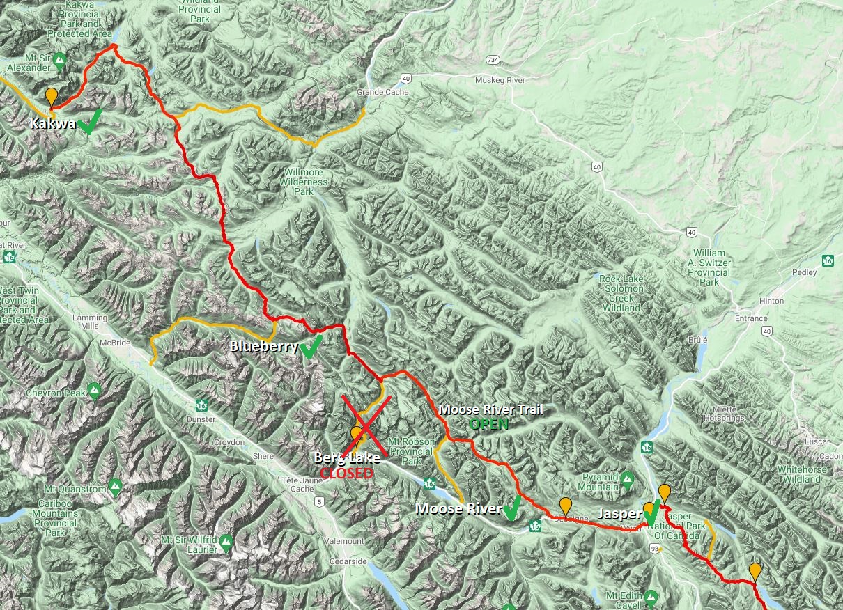
CLOSURE – Mount Robson Provincial Park: Due to ongoing assessment and construction following the significant damage from last year’s flooding, the entire Berg Lake Trail, including the parking lot, will be closed throughout 2022 for all activities and for both day and overnight users. Mount Robson Visitor Centre has temporarily suspended its resupply package service. The Moose River Trail is open, giving GDT Hikers 4 options to use as the GDT northern terminus other than the Berg Lake Trail: 1. Jasper 2. Moose River 3. Blueberry 4. Kakwa
CLOSURE UPDATE – Jasper National Park: 6-Passes Alternate Route is closed to all overnight random camping but is open to random day use activity.
CLOSURE – Forks campground in Peter Lougheed Provincial Park is closed all summer due to construction.
CLOSURE – Egypt Lake and Bryant Creek shelters are closed until further notice due to construction.
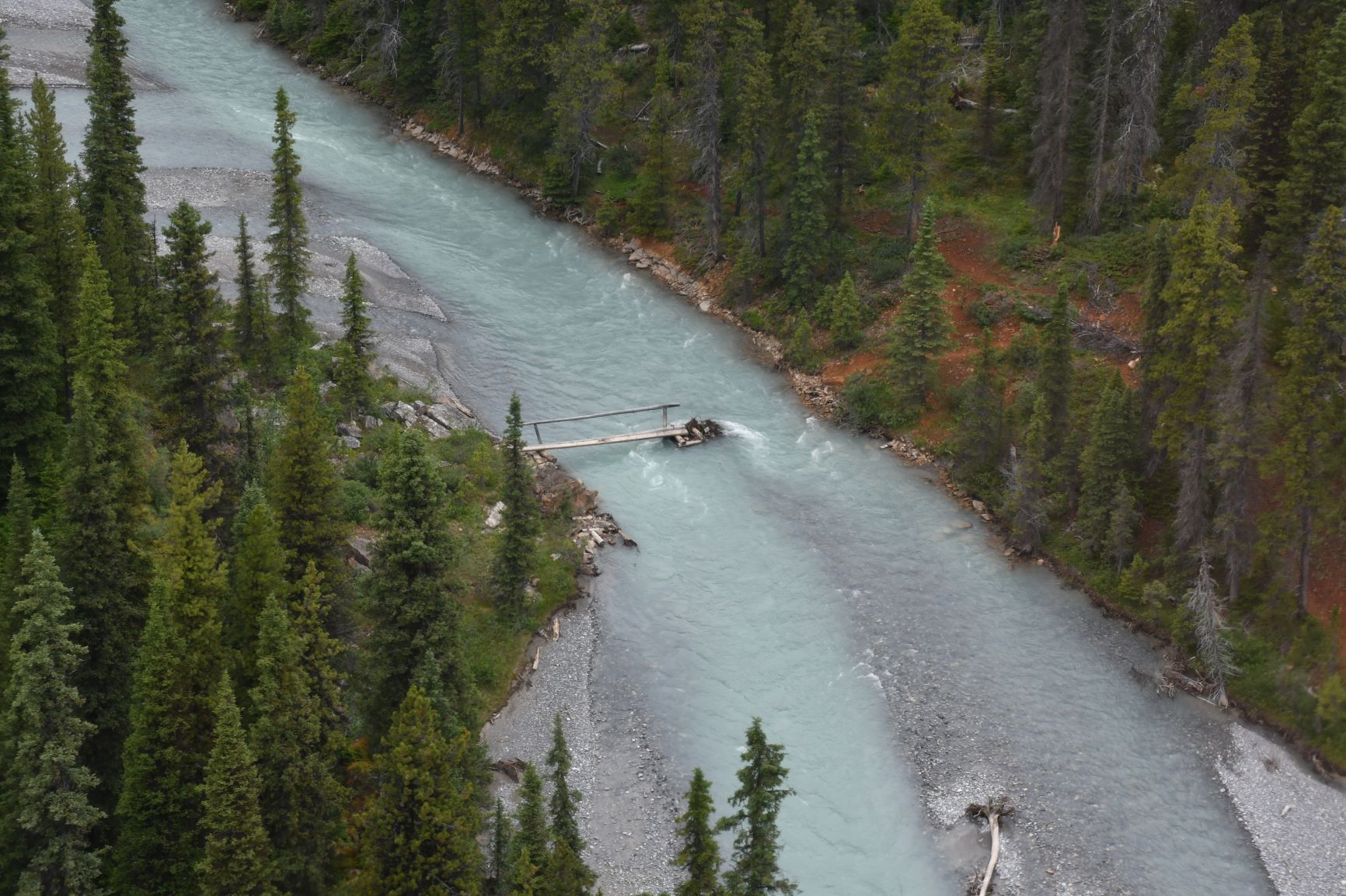
DAMAGEDBRIDGE – Chown Creek bridge (g2) was damaged by extreme flooding last year and only a portion of the bridge remains. If the bridge is impassable, NOBO hikers can bushwhack in the forest on the south bank of Chown Creek and reconnect to the GDT about 3 km upstream. SOBO hikers should not ford Chown Creek.
OPEN – The new High Rock Trail is open while trail crews continue working on it this summer, so be mindful and say hello!
SNOW MELT: Snowpack melt is up to four weeks behind normal spring melt levels meaning the GDT will likely not be snow-free until late July with some high passes having lingering snow all summer. Spring avalanche conditions continue to exist so prepare accordingly. For up to date snow level data in BC, check out the Snow Survey Stations Interactive Map. In Alberta, check out the Alberta River Basins map (turn on the snow pillow layer).
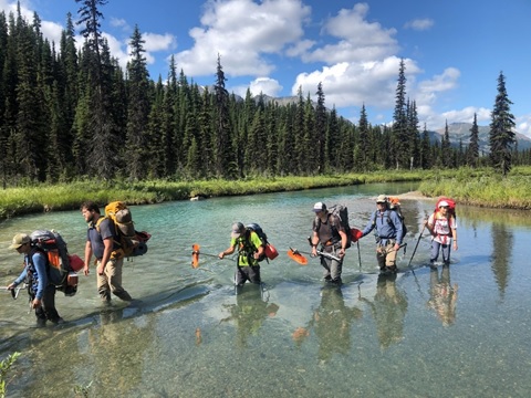
CREEKS: Rapid snow melt during this time of year results in high water levels and potentially dangerous creek crossings, particularly later in the day. Attempt to ford larger creeks early in the day when water levels are lowest.
BEARS: Bears are out and about. Be bear aware on the trails this summer: be alert, make noise and carry bear spray.
WARNING – Waterton Lakes National Park: Special caution is recommended while travelling on the Akamina Parkway and Cameron Lake Day Use Area due to a bear in the area. The bear has not been aggressive, but has approached people and attempted to obtain food.
ACCESS:
A Kananaskis Conservation Pass will be required for all vehicles visiting Kananaskis Country and provincial sites in the Bow Valley Corridor. The pass is not required for people arriving without a vehicle on foot, horseback or bicycle.
Highway 1 road construction 4 km east of Golden – No daytime stoppages from June 1 to September 15, 2022. Prepare for weekday nighttime closures (10pm-7am), delays and single lane traffic. If necessary, detour via Highway 93S and Highway 95
Walker Creek FSR is closed at km 37 due to unsafe road conditions, so be prepared for a lengthy road walk from the Bastille Creek trailhead. Where the road is open, a 4WD vehicle with high clearance is recommended.
Spring is transition time on the GDT. Above average snowpack and a cooler than average spring have resulted in lingering winter conditions on much of the GDT at elevations above 2000 metres. Valley bottom trails at lower elevations vary from bare and muddy to slushy and icy, while trails at higher elevation remain mostly snowbound. With warmer weather, trail conditions can change quickly from icy in the morning to slushy and slippery in the afternoon so plan for varying conditions.
TRAIL CLOSURES AND NOTICES:
COVID-19: We encourage everyone who spends time on the GDT this year to do so safely and continue to do your part to limit the spread of COVID-19. The GDTA continues to support single-day hikes or horseback rides on the GDT and longer (weekend or multi-day) trips where trails and trailheads are open. Be aware that some facilities and services along the GDT may be closed or limited. Hikers with plans on the GDT should pay close attention to provincial and local health restrictions as they evolve and be prepared to make changes to your plans in order to comply with these restrictions.
CLOSURE – Mount Robson Provincial Park: Due to ongoing assessment and construction following the significant damage from last year’s flooding, the entire Berg Lake Trail, including the parking lot, will be closed throughout 2022 for all activities and for both day and overnight users. Mount Robson Visitor Centre has temporarily suspended its resupply package service. The Moose River Trail is open, giving GDT Hikers 4 options to use as the GDT northern terminus other than the Berg Lake Trail: 1. Jasper Townsite 2. Moose River 3. Blueberry 4. Kakwa
CLOSURE – Kananaskis Country: Significant lingering snowpack at higher elevations throughout Kananaskis Country is impacting public safety and the functionality of several backcountry campgrounds including Turbine Canyon in Peter Lougheed Provincial Park, closed until July 5.
CLOSURE – Jasper National Park: 6-Passes Alternate Route is closed to all traffic and travel to limit visitor access in a sensitive area of the park.
CLOSURE – Forks campground in Peter Lougheed Provincial Park is closed all summer due to construction.
CLOSURE – Egypt Lake and Bryant Creek shelters are closed until further notice due to construction.
OPEN – The new High Rock Trail is open while trail crews continue working on it this June and July, so be mindful and say hello!
SNOW MELT: New snow has fallen in June and snowpack melt is up to four weeks behind normal spring melt levels meaning the GDT will likely not be snow-free until mid July with some high passes having lingering snow all summer. Spring avalanche conditions continue to exist so prepare accordingly. For up to date snow level data in BC, check out the Snow Survey Stations Interactive Map. In Alberta, check out the Alberta River Basins map (turn on the snow pillow layer).
CREEKS: Rapid snow melt during this time of year results in high water levels and potentially dangerous creek crossings, particularly later in the day. Attempt to ford larger creeks early in the day when water levels are lowest.
HIGH WATER ADVISORY in Waterton Lakes National Park due to rising water levels caused by recent rainfall and melting of a higher than average snowpack. Contact the Waterton Visitor Centre for the latest conditions before setting out.
ELK CALVING SEASON: mid May to June 30. Protective mother elk will aggressively protect their newborns by kicking and charging at people. Stay at least 30 metres away from all elk during this time of year. Pay attention to trail closures in known elk calving areas.
TICKS: It’s tick season. Long pants tucked into your socks are recommended. Be extra careful when in areas with a lot of underbrush and check yourself and your clothing after your hike.
BEARS: With spring’s arrival, bears are leaving their dens in search of food. Be bear aware on the trails this spring, make noise and carry bear spray.
ACCESS:
A Kananaskis Conservation Pass will be required for all vehicles visiting Kananaskis Country and provincial sites in the Bow Valley Corridor. The pass is not required for people arriving without a vehicle on foot, horseback or bicycle.
Seasonal Road Closure on Highway-6 in both directions from Township Road 21B to Alberta-Montana border.
Highway 1 road construction 4 km east of Golden – No daytime stoppages from June 1 to September 15, 2022. Prepare for weekday nighttime closures (10pm-7am), delays and single lane traffic. If necessary, detour via Highway 93S and Highway 95
Highway 40 from junction Highway 742 to junction Highway 541 (Highwood House) is closed until June 14, 2022.
Walker Creek FSR is closed at km 37 due to unsafe road conditions, so be prepared for a lengthy road walk from the Bastille Creek trailhead. Where the road is open, a 4WD vehicle with high clearance is recommended.
Spring is in the air and this is transition time on the GDT. Valley bottom trails at lower elevations vary from bare and muddy to slushy and icy, while trails at higher elevation remain snowbound. With warmer weather, trail conditions can change quickly from icy in the morning to slushy and slippery in the afternoon. Plan for varying conditions – warm layers, boots, snowshoes, cleats and/or poles are recommended.
TRAIL CLOSURES AND NOTICES:
COVID-19: We encourage everyone who spends time on the GDT this year to do so safely and continue to do your part to limit the spread of COVID-19. The GDTA continues to support single-day hikes or horseback rides on the GDT and longer (weekend or multi-day) trips where trails and trailheads are open. Be aware that some facilities and services along the GDT may be closed or limited. Hikers with plans on the GDT should pay close attention to provincial and local health restrictions as they evolve and be prepared to make changes to your plans in order to comply with these restrictions.
CLOSURE – Mount Robson Provincial Park: Due to ongoing assessment and construction following the significant damage from last year’s flooding, the entire Berg Lake Trail, including the parking lot, will be closed throughout 2022 for all activities and for both day and overnight users. Mount Robson Visitor Centre has temporarily suspended its resupply package service. The Moose River Trail is open, giving GDT Hikers 4 options to use as the GDT northern terminus other than the Berg Lake Trail: 1. Jasper Townsite 2. Moose River 3. Blueberry 4. Kakwa
CLOSURE – Jasper National Park: 6-Passes Alternate Route is closed to all traffic and travel to limit visitor access in a sensitive area of the park.
TICKS: Tick season has started. Be extra careful when in areas with a lot of underbrush and check yourself and your clothing after your hike.
BEARS: With spring’s arrival, bears are leaving their dens in search of food. Be bear aware on the trails this spring, make noise and carry bear spray.
SNOW MELT: Snow levels in the southern and central Rockies are higher than average for this time of year. Spring avalanche conditions continue to exist so prepare accordingly. For up to date snow level data in BC, check out the Snow Survey Stations Interactive Map. In Alberta, check out the Alberta River Basins map (turn on the snow pillow layer).
ACCESS:
A Kananaskis Conservation Pass will be required for all vehicles visiting Kananaskis Country and provincial sites in the Bow Valley Corridor. The pass is not required for people arriving without a vehicle on foot, horseback or bicycle.
Highway 1 is closed for road construction 4 km east of Golden, until May 20, 2022. Detour via Highway 93S and Highway 95.
Highway 40 from junction Highway 742 to junction Highway 541 (Highwood House) is closed until June 14, 2022.
Winter conditions are here. Snow is falling on the GDT and accumulating at high elevations so expect wet, icy and slippery trail conditions. Boots, hiking poles, snow cleats or snowshoes are recommended. Temperatures are below freezing, so be prepared for winter conditions and short days when travelling into the backcountry this winter.
Remember that the GDT is not designed for snow travel and is not maintained in the winter. When the trail is covered in snow, finding it may be impossible so excellent navigation skills are required. Hiking or skiing on the GDT when it’s snow covered means exposing yourself to potential avalanche risk. In many places, it’s unwise to travel the trail during these conditions. While planning your hike, research snow conditions and check out the Canadian Avalanche Centre for the latest avalanche bulletins.
TRAIL CLOSURES AND NOTICES:
CLOSURE – Mount Robson Provincial Park: The Kinney Lake Road, parking lot and Berg Lake Trail remain closed and reservations for the Berg Lake Trail in 2022 have been postponed until further notice. Stay tuned for updates regarding access in 2022.
SEASONAL CLOSURE – Jasper National Park: The GDT is closed from Four Point Campground (e15) to Trapper Creek (e24) and from Moose Pass (f15) to Bess Pass (g3) from November 1, 2021 to May 15, 2022, to prevent winter trails from facilitating an unnatural level of predator access to threatened woodland caribou.
COVID-19: We encourage everyone who spends time on the GDT this year to do so safely and continue to do your part to limit the spread of COVID-19. At this time, the GDTA supports single-day hikes or horseback rides on the GDT and longer (weekend or multi-day) trips where trails and trailheads are open. Some facilities and services along the GDT may be closed or limited due to the pandemic. Hikers with plans on the GDT should pay close attention to provincial and local health restrictions as they evolve and be prepared to make changes to your plans in order to comply with these restrictions.
Turbine Canyon and Forks backcountry campgrounds in Peter Lougheed Provincial Park are closed due to construction.
Egypt Lake and Bryant Creek shelters are closed until further notice.
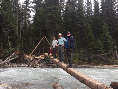
A new bridge was installed over Cairnes Creek on September 12, 2021.
Chown Creek bridge (g2) has been damaged by extreme flooding and only a portion of the bridge remains.
ACCESS:
Winter conditions exist on many mountain highways and roads. Roads can be snowy and icy so check for the latest conditions before you travel and carry chains and/or winter tires. For more information, check out Alberta 511 and Drive BC.
Highway 40 is seasonally closed from Peter Lougheed Provincial Park to Highwood House beginning December 1.
Forestry Trunk Road 940 is seasonally closed south of Cataract Creek and northwest of Plateau Mountain Road beginning December 1.
Sunshine Village has re-opened, including the road and gondola.
Highway 1 road construction 4 km east of Golden: December 1-23, single lane alternating traffic in effect 9am to 3pm and 6pm to 10pm daily. Expect delays up to 30 min. Hwy will be closed from 10pm to 7am nightly. Detour via Highway 93S and Highway 95.
Repairs to the Walker Creek FSR will continue next spring. When the road is open, a 4WD vehicle with high clearance is strong recommended.
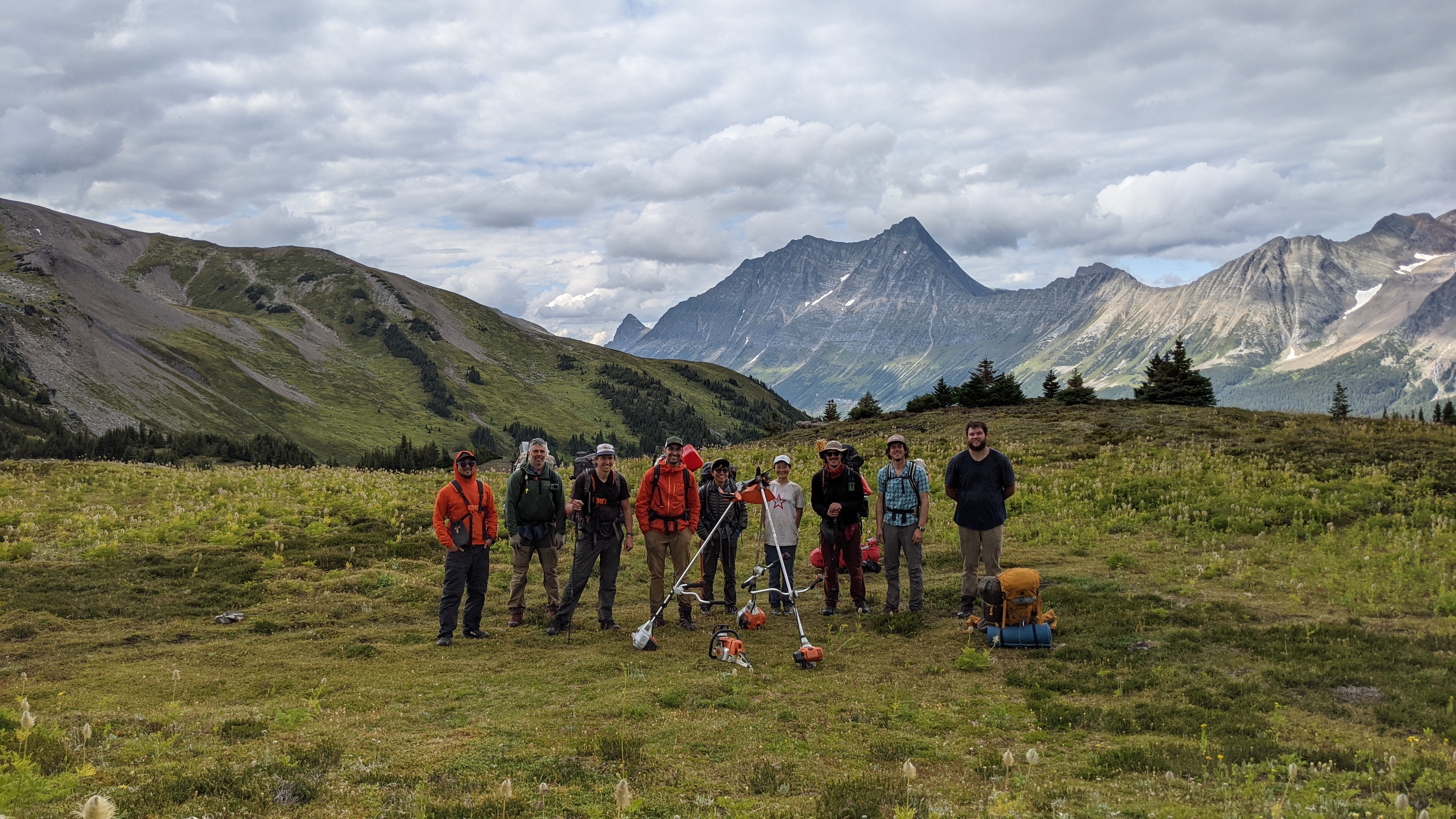
For this year’s Trail Building & Maintenance article we decided to let the volunteers tell in their own words about the trail crew trips. Over and above these reports there was one major “Scouting Trip” early in the spring, which besides setting the stage for all the High Rock trips, resulted in some major switchback building north from Window Mountain Lake. Also there were our first “Adopt a Trail” trips to test a new way to monitor and perform needed light maintenance on sections of the GDT. There is a separate article explaining them. In the meantime enjoy these volunteer trip reports and their stories.
Trips 1, 11, and 12
by Paul Jollymore
Three years ago my wife and I were enjoying a motorhome tour of Europe, when I thought to myself, that hiking in the mountains with a backpack held little appeal. Way too much effort. Upon our return home I realized that chocolate croissants were not on the recommended guidelines for daily breakfasts, and a demand for a fitness routine prompted me to the GDT. I’d completed Waterton to Sunshine in 2020, then the Rockwall to Saskatchewan River Crossing in 2021, and Jasper is planned for 2022. Joining the GDTA in 2020 was a great way to contribute to a trail I intended to use. Plans were in a flux in 2020 due to Covid but significant work was made along the High Rock Trail.
In 2021, the call for volunteers was disrupted over the winter but June approached and the preliminary bridge building project at Cairnes Creek – Trip 1, got the green light just in time. Enroute to the site, a road washout prevented progress so plan B prompted Dave, Doug, Rob, and I to head to the Atlas staging area north of Blairmore to do a little work on an alternate trail bypassing a section of road walk.
A second attempt at the Cairnes Creek bridge project – Trip 11, later in June brought Dave, Robert, Rob, David, Linnie, Doug, Tommy, and I out in an attempt to drag a generous size log across the creek as a suitable crossing. Our chainsaw winch and rigging wasn’t quite up to the task so a temporary crossing was left in place to accommodate foot traffic for the season. Our crew also headed to Lambe Creek crossing, clearing some trail along the way, and completed a repair job on the handrail at the bridge.
The third attempt – Trip 12, was made early in September when Dave, Rob, Robert, and I returned to Cairnes Creek with more rigging hardware. Robert provided us with a setup that managed to wrestle a 2.5 tonne log 40 feet across the creek without it even touching the water. Kudos to a well executed plan!
Each of these work parties required members to bring their own camping equipment and food. A common shelter area and cooking facilities were provided. Members had to come prepared to daypack to a worksite, pack a lunch, and bring suitable clothing for the day. While each of these work parties had a clear objective, the leads remained flexible when facing obstacles and reasonable alternatives were adopted as we went along. The work was strenuous but never overwhelming and the participants all expressed positive feedback on the experience.
I completed my GDT hike through the Cairnes Creek section in July and stopped for a break and encountered two other GDT hikers NOBO, and one hiker SOBO, as well as a family of four out for a dayhike in the 20 minutes I sat there. Andrew was the SOBO thru-hiker who completed the entire GDT in 20 days, aiming for 60 km per day and setting a record for the GDT’s Fastest Known Time in the process. The trail is only going to become more popular and it’s rewarding to know that our efforts contribute to the success and enjoyment of others.
Trip 2
by Melanie Sampson
The cool mountain air is crisp and the larch trees have turned, adding a splash of vibrant gold across the landscape along the Great Divide Trail. After an unusually hot and dry summer, the change in temperature is welcomed. During this transition of the seasons, I find myself reflecting on some of those long summer days; this year, I look back upon my incredible volunteer trail building and maintenance trip with the Great Divide Trail Association, and do so with much gratitude.
My name is Melanie and I have lived in the Calgary area for over a decade and have made our nearby Rocky Mountains a huge part of my life. I love to hike, trail run, crosscountry ski, bike, and am usually even keen for a swim in frigid glacier waters. I have built a career in aviation that allows me to travel all over the world, but when my feet are back on Canadian soil, I am typically mountain bound. With the slowdown of travel throughout the Covid-19 pandemic, I have been able to spend more time exploring our nearby trails, and found myself gravitating towards taking part in one of the GDTA’s trail building and maintenance trips. I was fortunate enough to sign up for Trip 2 along the High Rock Trail in the Crowsnest area. I had no prior experience with trail maintenance and was relying on the instruction and guidance of Trip 2’s crew leads, the positivity and encouragement of my crew mates, and my own eagerness to contribute to this ongoing project that is, quite frankly, remarkable.
Upon our crew coming together and meeting each other for the first time, we quickly bonded over our shared love of the trail, exploring wild places, and this magnificent thing called the Great Divide Trail. Together we shared stories from the trail; our favourite backcountry snacks and meals, how to make said meals from scratch and as close to gourmet as possible, swapped gear recommendations, and of course, shared tales of everyone’s previous wildlife encounters. While we all came from different walks of life, with varying degrees of experience building and maintaining trails, we came together naturally to dedicate a week of our time for the betterment of the trail so that others, like ourselves, could enjoy the beauty that lies within the Crowsnest area.
The days were extremely hot – topping out at 37°C! – but our team worked tirelessly, as we were all keen to make our trip leaders, Dave Hockey, Doug Borthwick, and Peter LaBastide proud. What our group was able to accomplish was incredible; the Scout Clearing team was able to flag and chainsaw nearly 2 km of new corridor south of camp, while the Tread team cleared blowdown and improved 3 km of trail north of camp, built new tread for 200m in the First Creek Valley, and 160m of new trail towards Racehorse Shoulder. Trip 2’s crew led the way and set the standard for the next six trail crews to follow, and the first 160m of trail built was used as an example for the next 5 km of trail up and over Racehorse Shoulder that saw more than 200 grateful hikers this summer. What an accomplishment!
I feel very honoured and grateful to have been able to spend a week with such fine individuals, who were all so inspiring and dedicated to maintaining, protecting and promoting the Great Divide Trail. I’d recommend taking part in a trail building trip to anyone, especially if our Rocky Mountains held a special place in their hearts; what a fulfilling experience! Thank you, Great Divide Trail Association for your incredible work; I’m already looking forward to next year!
Trip 3
by Emily Mayes
My name is Emily and I am an undergraduate student at McGill. I stumbled upon the GDTA website and signed up for this trail maintenance trip without knowing much about the Great Divide Trail or any idea of what to expect. I am so glad I did! I could not have asked for a better opportunity to learn about the trail building process and to spend some time in the mountains.
The trip was a resounding success. Most of us were first time volunteers with the Great Divide Trail and had little previous trail maintenance experience. We learned a lot from Doug, Dave, Peter, and the returning volunteers. I really can’t thank the trip leaders enough for sharing their knowledge and for their constant support and kindness. What our team might’ve lacked in trail building experience, we made up for with enthusiasm. It was energizing and motivating to be working alongside people with such passion for the mountains and the Great Divide Trail.
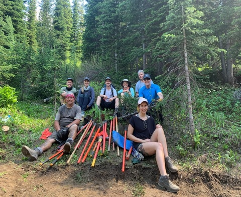
Trip 3 was a hot one. It had been +35C degrees for a week across most of Alberta and BC when we arrived at camp. It was slightly cooler in the mountains, but we were very much still in the midst of a heat wave every day of trail building. It didn’t slow us down too much though! Everyday we’d hike a very convenient 5 minutes from base camp to the start of our trail. From there we’d split into a few groups – scouters/chainsawers, trimmers, pulaskiers and then a finishing crew. Doug was great at noticing people’s predispositions for specific jobs and the work went very smoothly. We plugged along, breezing through sections of nice soft earth and taking our time on various other terrains permeated by stumps, roots and rocks and on intense side slopes. All said and done, we managed to complete about 1.3 km of beautiful 15 degree grade trail, nearly completely free of tripping hazards. (I will never be able to walk a trail and take it for granted again.) After four days of intense sunshine, the weather cooled down and we woke up to foggy skies instead of mountains on the final day. It rained on our way back down to the Atlas Staging Area and the rain was such a wonderful (and refreshing) conclusion to such an incredible week.
Trip 4
by Doug Borthwick
This trip saw the second of three youth groups help with building new trail. The Outdoor Council of Canada (OCC) on this outing, Crowsnest Bible Camp on the previous, and the Junior Forest Rangers on Trip 7, were major drivers to get this year’s work done up and over Racehorse Shoulder. Their youthful vigor and enthusiasm inspired other veteran trail builders immensely.
Trip 4 was the only one other than the Jackpine (Trip 10), which saw any significant rainfall during a very dry and hot summer. There were two nights of heavy rain and hail and the new tents and wood stove were very much appreciated.
This trip was the final one for the forward crew of trail blazers and chainsawers to finish their work, and at the end we said goodbye to Dave, Peter, Julien, and Jim. The tread crew built another hard earned 1.2 km of new trail.
The OCC having now become veterans, recruited an amazing cook to add to their camp. There were usually lots of leftovers, and Allistair was front and center showing the rest of the camp how to properly yogi an extra meal. I really don’t think we worked this crew hard enough as every morning at 5am, we had one ambitious volunteer who had to complete a 5 km trail run before breakfast. The last day the heat and dry weather returned and this crew was glad to dry out before heading home.
Trip 5
by Cody Hemmerling
I am Cody Hemmerling, a fourth year university student that took part in High Rock Trail (HRT) Trip 5. I signed up for the trip because I thought it was a great way to get involved with the GDT, and it provided an excellent opportunity to spend a longer amount of time in the bush. My experience was so much more than that. We had a small crew of seven, and while these people were complete strangers to me before the trip, by the end of the trip it was sad to leave them all, even the girl who wouldn’t shut up about Denny’s ?. It is really true that the outdoors brings people together.
I remember the first day Doug mentioned that the average volunteer makes about 20 metres of new trail in a day and thinking to myself “that seems like nothing, I bet I will do so much more than that”. Turns out Doug knew what he was talking about, trail building is hard work. We ended up finishing the switchbacks on the north side of Racehorse Shoulder before blazing a trail across Racehorse Shoulder, and beginning to build the trail coming down the south side towards Racehorse Road. We were fortunate enough to meet around 20 thru-hikers throughout our trip, all from different backgrounds, with a surprisingly high number of hikers hailing from Quebec.
Highlights of the trip included working atop the stunning Racehorse Shoulder, seeing mountain goats, and above all else the time spent in camp storytelling and hanging out with such an amazing group of people.
Trip 6
by Jeremy Bateson
In mid-July 2021, the GDTA ran Trip 6 to Cataract Creek on the Original GDT. Dave Higgins led a group of six people to install a new bridge over the creek and a smaller bridge across a nearby gulley. A helicopter and personnel from Alberta Parks dropped the 30 foot bridge logs across the creek as well as all the tools. The work crew hiked in 4 km from a nearby logging road access and set up tents around an old snowmobiling shack. Dave tried out a small motor bike and trailer to bring in extra load, but the trail proved to be too boggy. The bridge construction went well. As it turned out, six people was a very good group size for this work.
To start the creek work, the remains of the old bridge were cut away and cleared. After the sills were prepared, the logs’ ends were shifted into position. Dave brought a small chain fall with tripod to help shift the log ends. Once the work was done the tripod legs were used as additional materials. The group made an improvised winch with two 2×4’s to drag the logs to final position. The bulk of the bridge was complete and braced by the end of the second day. The bridge deck was finished with planks and an edge runner.
On day 3 the main group headed up the slope to bridge a large gulley. The gulley bridge was made with locally felled trees and was mainly complete by the end of that day.
On the final day the group walked back to the ridge north of Lost Creek, doing general trail maintenance as they went. They cleared some minor blowdown and trimmed back overgrowth.
The overall trip was a success and accomplished a lot of work with a small team. The use of a helicopter for select work was definitely a benefit.
It was a pleasure to see many hikers during the four work days. At least 10 people passed the crew and shared their insights with the crew.
Trip 7
by Kathleen Gallagher
Trip 7 began at a very civilized 11:30am at the Atlas Staging Area near Coleman in Crowsnest Pass. There I met my friends for the week: Jud, Christine, and Tom, a small but mighty crew. After a quick backtrack into town to pick up some washers to repair the hose, we were ready to drive up the gravel road to the snowmobile staging area where we would hit the trail. As we neared the parking area, out popped Doug on an ATV from the trees, smiling, waving and ready to embark on another successful week of trail building.
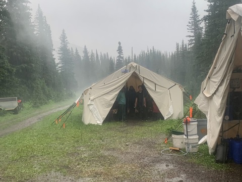
Unbeknownst to me, Doug would be towing our gear on the ATV, to the base camp for the week. Truly a missed opportunity since I had packed “backpacking” style. Next time I’m bringing a cot! A quick jaunt up the road and we arrived at our luxurious accommodations: two large common area tents, one for the food preparation/cooking and another for lounging, complete with a library of Great Divide books and a woodstove! We set up our individual tents and Doug gave us a tour of the camp, instructing each of us on our duties. The brave campers touched the live wire for the bear fence to ensure it was working, Christine and I did not. The bugs were crazy bad that first day but got better as the week went on (not sure if that is related to my tolerance or actual conditions)!
The first day as we walked to our worksite, Doug gave us tips and tricks, pointing out challenges and opportunities experienced by the previous groups. His teaching speaks for itself as we were spoiled by the beautiful trail that had been created by the volunteers before us, providing us with smooth sailing and a seamless hike to our starting point. On our commute to work we were fortunate enough to travel over a beautiful ridge, treated to magnificent views of Crowsnest Mountain, Seven Sisters Mountain, Mount Ward and the valley below. I had been a bit nervous about using the heavy and sharp tools required for trail building in the wild, but after a few minutes watching my skilled colleagues Jud and Tom, I felt up to the challenge! I’m glad I tried it out since trail creation is so rewarding! It felt awesome to demolish giant roots and also to look back at what we had achieved each day and think about how we were contributing to a little piece of history.
Day two and three were our main working days and our supervisor Doug was not too tyrannical. Some breaks were allowed and we even had lunch off! I would escape off to the beautiful ridge at lunch to catch some wind to cool off in the heat. An added bonus would be if the gusts blew the bugs away. All in all we had spectacular weather, not a drop of rain and I couldn’t have asked for anything better. Day four was a more lenient day, as it was the last and everyone was rather tired. Still, we built about 330 metres of trail through varied terrain, which we were happy with as only a four person group. 330 metres doesn’t sound like much on a 12,000 metre trail, but a journey of a thousand miles starts with a single step and that is 330 metres that wasn’t there before! I know that the folks that were going in straight lines up and down ridges with no gentle switchbacks to smooth the elevation appreciated it – they even brought us beer!
On our last night to close out the trip, Bartender Jud was generous with his supplies, and Tom and Doug shared countless stories from their past years of trail activities. Christine finally revealed her age to us and went from very impressive to legendary. Thank you to my wonderful companions of various backgrounds for coming together and sharing such a great week with me. I still smile every time I remember the sense of accomplishment and I can’t wait to get back out there next summer!
Trip 8
by Sebastian Kanally
The backcountry, an important refuge. The pristine mountain air fills you with life, the human noise was left behind hours and days ago, the backcountry is a palate cleanser, the backcountry is always there to remind us who we really are.
I am Sebastian Kanally, I live in Amherstburg, Ontario, and the mountains have called my name ever since I first laid eyes on them in 2018. I flew out to hike in the mountains this year- 2021, and I saw the email that the GDTA was looking for volunteers to help build sections of the Great Divide Trail, and I could not pass up the chance. I am a philosopher that is humbled by our natural world. This was an awesome opportunity for me to give some of my labour to the GDTA and meet a diverse group of people interested in volunteering and the backcountry.
Volunteering with the Great Divide Trail Association is a truly enriching experience. I had never done it before, and the experience exceeded my expectations as it was lots of fun. I enjoyed learning how trail is built and why trails are built the way they are. It is a great experience to look back at a day’s work, to see a trail there that was not there the day before. The hard work you put in that day to help build a trail so that others can see these beautiful places. My small amount of work comes together with hundreds of other volunteers to help hikers and equestrians of all abilities to experience the sublime nature of this landscape, in this small corner of the largest intact land biome left on earth.
To volunteer one’s time to go live in the backcountry, no cell service, just living a truly minimalist and essential life, limiting one’s footprint and working collectively to achieve a goal, is brilliant. The walk to work is stunning. The greatest part of the trail building experience for me was learning and developing a more intimate knowledge about this beautiful landscape. The intricate and symbiotic relationships between all the plants and animals, such as the White Bark Pine, the Larch and Spruce trees, the Clark’s Nutcracker, the Grizzlies, and how this is all being impacted by climate change and human activity. The ecological wholeness of this pristine environment demands our respect and work to protect. You can learn about it, but until you spend time and actually experience the landscape it is hard to appreciate how complex of an ecosystem this is.
If you are looking for a fun way to get out into the backcountry with a group of people, I would highly recommend trail building with the GDTA. In an era of climate changing our ecosystems, to meaningfully contribute and do so with an organization that values keeping the ecosystem intact, is priceless. Different people bound by their passion and appreciation of the Rocky Mountains made this a very fun and enjoyable experience. These are amazing people and friends I never would have met without volunteering. All these different demographics coming together truly speaks to the value of building trail and volunteering with the GDTA.
Trip 9
by Doug Borthwick
This trip almost never got off the ground and was very close to being cancelled. What had started as a promising crew size of nine had seen multiple last minute cancellations to come down to a final crew size of three with an added trip camp manager. A last second appeal brought out two fresh young recruits – Mark and Shawn, who worked back to back trips with no breaks. Combined with the Junior Forest Rangers working the changeover day, Jud leading, Stuart staying an extra changeover day, and three camp managers on Trips 7 and 8 wanting to help with the trail work, the three Canmorians who drove through the night to help for two critical days, and the dedicated work of all the original crew members, we were able to complete the remaining 1.5 km of trail south of Racehorse Shoulder. There cannot be enough thanks to this amazing group who were critical in finishing the final connection to Racehorse road.
The volunteers who worked Trip 9 were treated to a meeting with two of this year’s GDT legends. First was Andrew Cottrell who came flying at the group from the north during his record Fastest Known Time (FKT) 20 day hike of the GDT. This guy had time to stop and kibitz for a long time with the trail crew and in fact had to be encouraged to leave so they could get on with building more switchbacks. The second was Peter Whitehead, the 77 year-old who’s thru-hiking story inspired so many. Peter did not have any switchbacks to work with as he climbed determinedly from Racehorse road but he still had a laugh and a joke as he passed the trail crew trying desperately to get just a couple of extra meters done to help him on his way.
This crew amazingly finished their goal of attaining the road one full day early.
Trip 10
by Samuel Yamamoto (Prepper)
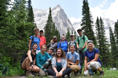
I’m someone relatively new to backpacking and thru-hiking, and I’m working my way up the GDT in sections over many summers. Last year I had the pleasure of doing Section A from Waterton to Crowsnest Pass and I was hooked! This summer I was going to embark on my own solo excursion on Sections B and C of the GDT until I saw the call for volunteers to help with trail maintenance in the Jackpine Valley. The dates lined up perfectly for me and being flown out by helicopter sealed the deal. I emailed Dan Durston right away to let him know I’m interested and available, and thankfully I was chosen to go. The journey started with about an 8.5 hour drive to McBride, BC from Lethbridge, followed by about another 45 minutes on a dirt road to where the helicopter would pick us up the next morning. Our crew consisted of nine of us from Alberta and BC.
During the first night, it gradually started raining and did not let up. The helicopter came in the rain after a search and rescue delay. We were dropped off just short of the peak of Big Shale hill where the peak was too socked in to be dropped off safely on it. It took the helicopter three trips to get all nine of us, our gear, and trail maintenance gear up. The trail maintenance gear included three brush saws, three hand saws, three large cutters, one chainsaw, and a ton of fuel in jerry cans to match. In addition we had several trail cameras to monitor trail traffic and wildlife that needed to be set up, and some cans of orange spray paint to “blaze” the trail. We started right away at the treeline on clearing the trail. At first we had three crews of two, a brush saw operator and another to follow, clearing the trail of cut debris. Chainsaw operator and spotter were together throughout the week as they were the only ones that had been trained and certified, and then a swamper in the back. We worked through the rain on day one with little glimmers of sun giving us a small reprieve from the rain.
We set up camp at the end of day one and I discovered most of my gear got wet through and through. My sleeping bag was about 50% wet and I was worried I was going to have major issues through the night. When I started warming up, even in my wet bag, I realized it was going to be okay. We also coincidentally had 7 X-Mid tents by Dan Durston on the trip! In the beginning of day two we had to ford our first of many river fords. By this time, the rain clouds had subsided and we welcomed the warm sunlight.
Day two was working mostly uphill toward another ridge where our pace quickened as we went back up the treeline and the foliage of the trail lightened up. We averaged about a kilometer an hour with our pace. We also changed to a lead team of three brush saws, sweep, followed by the chainsaw and spotter, then three in the rear sawing and cutting brush and trees as well as clearing debris. By this time we had found a groove that was working for all of us.
On the evening of day three, we shared our site and spent time with Fidget and Neon on their trans-American journey through South and North America. They were quite delightful and brought a fun energy to our camp.
There was a burn zone that we crossed through that was heavy work for the two-person chainsaw crew. They were well behind the pack clearing away fallen burned trees. We continued along the Jackpine River for the most part, clearing mostly thick willows. Our pace improved as each day went, and overall we were able to clear about 18 km of the trail.
The difference from the before and after our maintenance was enormous. Before, you couldn’t walk without getting whipped by willows or having to navigate through a thicket of trees or brush. After, you could hike comfortably without any foliage getting in your way.
As the end of the week came, we changed our focus to route finding through the marsh of the upper Jackpine Valley. Anyone who has traveled through this section knows what a nightmare this area is. We blazed trees through this section as an actual trail through the marsh is near impossible to establish. The established trail heading up to Blueberry Lake past the marsh was much more pleasant and the abundance of berries along the trails were a fantastic treat.
The views at the top of the pass were incredible and the weather treated us well. We descended to Blueberry Lake after six days. Most of our crew went ahead and finished to our cars while three stayed back and camped the night at Blueberry Lake.
The entire week was an amazing effort from nine different people who came together to make our GDT just a little better. It was tough, grueling work at times as the outdoors often are, but the rewards of not only spending a week in remote wilderness but making a tangible difference on the trail for years to come were worth every bit of the tough grueling work.
Thank you to all
Many thanks to all of this year’s volunteers! Thanks also go out to our supporterswhose generosity has greatly enhanced our trail building and maintenance capabilities, including Alberta Equestrian Federation, Alberta Environment and Park, Alberta Culture and Status of Women, Alberta Forest & Garden, Stihl, and Columbia Basin Trust.
Fall colours are here, and so is the snow! Winter is coming and snow has fallen at higher elevation on most of the GDT so expect wet, slippery and muddy trail conditions. Nighttime and early morning temperatures are below freezing, so be prepared for cold temperatures and shorter days when travelling into the backcountry this fall.
TRAIL CLOSURES AND NOTICES:
CLOSURE – Mount Robson Provincial Park: The Kinney Lake Road, parking lot and Berg Lake Trail are closed for construction. Reservations for the Berg Lake Trail in 2022 have been postponed until further notice. Mount Robson Visitor Centre has temporarily suspended its resupply package service. The Moose River Trail is open, giving GDT Hikers 4 options to use as the GDT northern terminus other than the Berg Lake Trail:
1. Jasper Townsite
2. Moose River
3. Blueberry
4. Kakwa
COVID-19: We encourage everyone who spends time on the GDT this year to do so safely and continue to do your part to limit the spread of COVID-19. At this time, the GDTA supports single-day hikes or horseback rides on the GDT and longer (weekend or multi-day) trips where trails and trailheads are open. Some facilities and services along the GDT may be closed or limited due to the pandemic. Hikers with plans on the GDT should pay close attention to provincial and local health restrictions as they evolve and be prepared to make changes to your plans in order to comply with these restrictions.
ELK RUTTING SEASON: It is elk rutting season until mid-October. Warning signs that read “ATTENTION – Elk Mating” have been posted at areas where elk herds often gather. Be aware that bull elk become extremely aggressive during rutting season so keep at least 30 metres away from all elk and never get between a male and female elk.
BEARS: It’s pre-hibernation feeding season for black and grizzly bears which increases the chances of running into a bear on the trail. It is easy to surprise a bear that is focussed on feeding so make noise while hiking in bear territory. Be alert, make noise, carry bear spray and if you see a bear, back away slowly and leave the area.
Turbine Canyon and Forks backcountry campgrounds in Peter Lougheed Provincial Park are closed due to construction.
Egypt Lake and Bryant Creek shelters are closed until further notice.
A new bridge was installed over Cairnes Creek on September 12, 2021.
Trail 7 near Jasper is closed to hikers due to grizzly and black bears frequenting the area so the GDT has been permanently re-routed here. At Soggy Dog Lake (e33), the new route follows Trail 4g to Edith Lake where it connects with Trail 18. Follow Trail 18 to Trefoil Lakes where you briefly follow Trail 4b past Mildred Lake to reconnect with Trail 7 next to the Athabasca River, which leads to Old Fort Point trailhead (e34).
Chown Creek bridge (g2) has been damaged by extreme flooding and only a portion of the bridge remains. Recent reports indicate that the creek is fordable 50 metres upstream of the bridge, allowing access to the campground on the north side of the creek. If the creek is impassable, NOBO hikers can bushwhack in the forest on the south bank of Chown Creek and reconnect to the GDT about 3 km upstream. SOBO hikers should not ford Chown Creek.
ACCESS:
Kananaskis Conservation Pass is required for all vehicles visiting Kananaskis Country and provincial sites in the Bow Valley Corridor starting June 1, 2021. The pass is not required for people arriving without a vehicle on foot, horseback or bicycle.
Sunshine Road is open but Sunshine Village will be closed for the entire 2021 season, including the shuttle and gondola.
Highway 1 road construction 4 km east of Golden, resulting in extended 24 hour closure in effect from September 20 to December 1, 2021. Detour via Highway 93S and Highway 95.
CLOSURE: Walker Creek FSR is closed at km 37 due to unsafe road conditions, so be prepared for a lengthy road walk from the Bastille Creek trailhead. Where the road is open, a 4WD vehicle with high clearance is strong recommended.
Be prepared for colder temperatures and shorter days when travelling on the trail this month. Due to recent precipitation, some sections of trails may be wet or muddy with snow at higher elevations.
TRAIL CLOSURES AND NOTICES:
CLOSURE – Mount Robson Provincial Park: The Berg Lake Trail is closed from Kinney Lake to Robson Pass for the remainder of the 2021 season due to continuing flood conditions causing washed out bridges, flooded campgrounds and unsafe trails. All campground reservations will be cancelled and fully refunded automatically. Mount Robson Visitor Centre has temporarily suspended its resupply package service and it is not expected to resume this summer. The Moose River Trail reopened August 1, giving GDT Hikers 4 options to use as the GDT northern terminus other than the Berg Lake Trail:
1. Jasper Townsite
2. Moose River (recently cleared)
3. Blueberry
4. Kakwa
COVID-19: We encourage everyone who spends time on the GDT this year to do so safely and continue to do your part to limit the spread of COVID-19. At this time, the GDTA supports single-day hikes or horseback rides on the GDT and longer (weekend or multi-day) trips where trails and trailheads are open. Some facilities and services along the GDT may be closed or limited due to the pandemic. Hikers with plans on the GDT should pay close attention to provincial and local health restrictions as they evolve and be prepared to make changes to your plans in order to comply with these restrictions.
ELK RUTTING SEASON: It is elk rutting season until mid-October. Warning signs that read “ATTENTION – Elk Mating” have been posted at areas where elk herds often gather. Be aware that bull elk become extremely aggressive during rutting season so keep at least 30 metres away from all elk and never get between a male and female elk.
FIRES: Cooler temperatures and rain/snowfall have reduced fire danger levels in the Rockies and campfire bans have been lifted. If you must have a campfire in the backcountry, ensure you follow the rules.
BEARS: It’s pre-hibernation feeding season for black and grizzly bears which increases the chances of running into a bear on the trail. It is easy to surprise a bear that is focussed on feeding so make noise while hiking in bear territory. Be alert, make noise, carry bear spray and if you see a bear, back away slowly and leave the area.
Turbine Canyon campground in Peter Lougheed Provincial Park is closed all summer for construction.
Egypt Lake and Bryant Creek shelters are closed until further notice.
A new bridge was installed over Cairnes Creek on September 12, 2021.
Trail 7 near Jasper is closed to hikers due to grizzly and black bears frequenting the area so the GDT has been permanently re-routed here. At Soggy Dog Lake (e33), the new route follows Trail 4g to Edith Lake where it connects with Trail 18. Follow Trail 18 to Trefoil Lakes where you briefly follow Trail 4b past Mildred Lake to reconnect with Trail 7 next to the Athabasca River, which leads to Old Fort Point trailhead (e34).
Chown Creek bridge (g2) has been damaged by extreme flooding and only a portion of the bridge remains. Recent reports indicate that the creek is fordable 50 metres upstream of the bridge, allowing access to the campground on the north side of the creek. If the creek is impassable, NOBO hikers can bushwhack in the forest on the south bank of Chown Creek and reconnect to the GDT about 3 km upstream. SOBO hikers should not ford Chown Creek.
ACCESS:
Kananaskis Conservation Pass is required for all vehicles visiting Kananaskis Country and provincial sites in the Bow Valley Corridor starting June 1, 2021. The pass is not required for people arriving without a vehicle on foot, horseback or bicycle.
Sunshine Road is open but Sunshine Village will be closed for the entire 2021 season, including the shuttle and gondola.
Highway 1 road construction 4 km east of Golden, resulting in extended 24 hour closure in effect from September 20 to December 1, 2021. Detour via Highway 93S and Highway 95.
CLOSURE: Walker Creek FSR is closed at km 37 due to unsafe road conditions, so be prepared for a lengthy road walk from the Bastille Creek trailhead. Where the road is open, a 4WD vehicle with high clearance is strong recommended.
Most of the recent early season snow on the GDT has melted but cooler temperatures and shorter days are signs that summer in the mountains is coming to an end. Elsewhere trails are generally in good condition but expect some wet and muddy sections following recent periods of rain or snow.
TRAIL CLOSURES AND NOTICES:
CLOSURE – Mount Robson Provincial Park: The Berg Lake Trail is closed from Kinney Lake to Robson Pass for the remainder of the 2021 season due to continuing flood conditions causing washed out bridges, flooded campgrounds and unsafe trails. All campground reservations will be cancelled and fully refunded automatically. Mount Robson Visitor Centre has temporarily suspended its resupply package service and it is not expected to resume this summer. The Moose River Trail reopened August 1, giving GDT Hikers 4 options to use as the GDT northern terminus other than the Berg Lake Trail:
1. Jasper Townsite
2. Moose River (recently cleared)
3. Blueberry
4. Kakwa
COVID-19: We encourage everyone who spends time on the GDT this year to do so safely and continue to do your part to limit the spread of COVID-19. At this time, the GDTA supports single-day hikes or horseback rides on the GDT and longer (weekend or multi-day) trips where trails and trailheads are open. Some facilities and services along the GDT may be closed or limited due to the pandemic. Hikers with plans on the GDT this summer should pay close attention to provincial and local health restrictions as they evolve and be prepared to make changes to your plans in order to comply with these restrictions.
FIRES: Cooler temperatures and rain/snowfall have reduced fire danger levels in the Rockies and campfire bans have been lifted. If you must have a campfire in the backcountry, ensure you follow the rules.
BEARS: It’s berry season! Berry bushes border trails, roads and campgrounds on the GDT, and black bears and grizzly bears are feeding on berries right now. It is easy to surprise a bear that is focused on feeding, so be extra bear aware on the trails: stay alert, make noise and carry bear spray.
CLOSURE – Waterton Lakes National Park: Twin Lakes and Snowshoe campgrounds are closed due to a black bear frequenting the area. The bear has not been aggressive, but has approached people and attempted to obtain food.
Turbine Canyon campground in Peter Lougheed Provincial Park is closed all summer for construction.
Egypt Lake and Bryant Creek shelters are closed until further notice.
Cairnes Creek (d9): A new temporary bridge has been installed 150 metres upstream of the old bridge. The access route is flagged on both sides of the creek.
Trail 7 near Jasper is closed to hikers due to grizzly and black bears frequenting the area so the GDT has been permanently re-routed here. At Soggy Dog Lake (e33), the new route follows Trail 4g to Edith Lake where it connects with Trail 18. Follow Trail 18 to Trefoil Lakes where you briefly follow Trail 4b past Mildred Lake to reconnect with Trail 7 next to the Athabasca River, which leads to Old Fort Point trailhead (e34).
Chown Creek bridge (g2) has been damaged by extreme flooding and only a portion of the bridge remains. Recent reports indicate that the creek is fordable 50 metres upstream of the bridge, allowing access to the campground on the north side of the creek. If the creek is impassable, NOBO hikers can bushwhack in the forest on the south bank of Chown Creek and reconnect to the GDT about 3 km upstream. SOBO hikers should not ford Chown Creek.
ACCESS:
Highway 6 is closed at the Belly River crossing 17 km past the turnoff to Waterton Lakes National Park, to the Alberta-Montana border due to the closed International Border.
Kananaskis Conservation Pass is required for all vehicles visiting Kananaskis Country and provincial sites in the Bow Valley Corridor starting June 1, 2021. The pass is not required for people arriving without a vehicle on foot, horseback or bicycle.
Sunshine Road is open but Sunshine Village will be closed for the entire 2021 season, including the shuttle and gondola.
Highway 1 road construction 4 km east of Golden, resulting in weekday nighttime closures (10pm-7am) and single lane traffic until September 2, 2021. If necessary, detour via Highway 93S and Highway 95.
Walker Creek FSR is open to Bastille Creek trailhead. It is a very rough and muddy dirt road so a 4WD vehicle with high clearance is strongly recommended.
Wildflowers are blooming! While pandemic recovery continues and the world slowly reopens, staying active in the outdoors is an excellent way to keep your body and mind healthy. We encourage everyone who spends time on the GDT this year to do so safely and continue to do your part to limit the spread of COVID-19.
TRAIL CLOSURES AND NOTICES:
COVID-19: At this time, the GDTA supports single-day hikes or horseback rides on the GDT and longer (weekend or multi-day) trips where trails and trailheads are open. Some facilities and services along the GDT may be closed or limited due to the pandemic. Hikers with plans on the GDT this summer should pay close attention to provincial and local health restrictions as they evolve and be prepared to make changes to your plans in order to comply with these restrictions.
The new High Rock Trail is open while volunteer trail crews continue working on it this month, so be mindful and say hello!
Turbine Canyon campground in Peter Lougheed Provincial Park is closed all summer for construction.
Cairnes Creek (d9): A new temporary bridge has been installed 150 metres upstream of the old bridge. The access route is flagged on both sides of the creek.
Trail 7 near Jasper is closed to hikers due to grizzly and black bears frequenting the area so the GDT has been permanently re-routed here. At Soggy Dog Lake (e33), the new route follows Trail 4g to Edith Lake where it connects with Trail 18. Follow Trail 18 to Trefoil Lakes where you briefly follow Trail 4b past Mildred Lake to reconnect with Trail 7 next to the Athabasca River, which leads to Old Fort Point trailhead (e34).
Mount Robson Provincial Park: Portions of the Berg Lake Trail and the Moose River Trail are closed until at least August 5 due to damage from extreme flooding. No detour is available. Upcoming trail passes and campground reservations will be cancelled and any fees will be fully refunded (no action is required by visitors). Additional details will be posted here as they become available.
Chown Creek bridge (g2) has been damaged by extreme flooding and only a portion of the bridge remains. If the bridge is impassable, NOBO hikers can bushwhack in the forest on the south bank of Chown Creek and reconnect to the GDT about 3 km upstream. SOBO hikers should not ford Chown Creek.
Kakwa Lake cabin is closed for maintenance July 14-20.
FIRES: While wildfires aren’t burning close to the GDT, smoke from wildfires burning in BC is present on much of the trail, causing poor air quality and limited visibility. Fire danger is high or extreme throughout the Rockies and fire restrictions or advisories are in effect along all of the GDT. Campfires are banned on all sections of the GDT in BC and most of Alberta including Waterton, Banff and Jasper national parks. If you must have a campfire in the backcountry, ensure you follow the rules.
SNOW MELT: Trails are mostly snow-free with some wet and muddy sections. Warm temperatures have resulted in rapid snow melt, slightly ahead of average for this time of year in most of the Rockies. For up to date snow level data in BC, check out the Snow Survey Stations Interactive Map. In Alberta, check out the Alberta River Basins map (turn on the snow pillow layer).
CREEKS: Warm temperatures and rapid snow melt have resulted in high water levels and potentially dangerous creek crossings, particularly later in the day. Attempt to ford larger creeks early in the day when water levels are lowest.
BEARS: Bears are out and about. Be bear aware on the trails this summer: be alert, make noise and carry bear spray.
WARNING: A food-conditioned bear has been frequenting Akamina Creek campground. Park officials have been made aware and are investigating.
ACCESS:
Highway 6 is closed at the Belly River crossing 17 km past the turnoff to Waterton Lakes National Park, to the Alberta-Montana border due to the closed International Border.
Kananaskis Conservation Pass is required for all vehicles visiting Kananaskis Country and provincial sites in the Bow Valley Corridor starting June 1, 2021. The pass is not required for people arriving without a vehicle on foot, horseback or bicycle.
Sunshine Road is open but Sunshine Village will be closed for the entire 2021 season, including the shuttle and gondola.
Highway 1 road construction 4 km east of Golden, resulting in weekday nighttime closures (10pm-7am) and single lane traffic until August 27, 2021. If necessary, detour via Highway 93S and Highway 95.
While pandemic recovery continues and the world slowly reopens, staying active in the outdoors is an excellent way to keep your body and mind healthy. We encourage everyone who spends time on the GDT this year to do so safely and continue to do your part to limit the spread of COVID-19.
At this time, the GDTA supports single-day hikes or horseback rides on the GDT and longer (weekend or multi-day) trips where trails and trailheads are open. Check with public health agencies for information near your starting point, along your route, and at your planned destination. Any GDT travel must comply with provincial and federal guidelines and laws.
TRAIL CLOSURES AND NOTICES:
Due to the ongoing COVID-19 pandemic, hikers with plans on the GDT this summer should pay close attention to provincial and local health restrictions as they evolve and be prepared to make changes to your plans in order to comply with these restrictions.
Effective June 15, recreational travel is again allowed in British Columbia.
Access to some Parks Canada visitor facilities and services may be limited.
BC Parks is providing BC residents with priority access to camping reservations until July 8, when non-BC residents will also be permitted to make camping reservations. Some BC Park facilities and services may be limited.
Alberta Parks campground reservations are open with reduced services and additional health guidelines and restrictions.
The new High Rock Trail is open while trail crews continue working on it this June and July, so be mindful and say hello.
Turbine Canyon campground in Peter Lougheed Provincial Park is closed all summer for construction.
Cairnes Creek (d9): The temporary bridge installed last year was destroyed over the winter. A new bridge will be installed in July. Cairnes Creek is glacial fed and a difficult ford so until a bridge is installed, it is recommended to ford the creek early in the morning when glacial melt is lowest.
Trail 7 near Jasper is closed to hikers due to grizzly and black bears frequenting the area so the GDT has been permanently re-routed here. At Soggy Dog Lake (e33), the new route follows Trail 4g to Edith Lake where it connects with Trail 18. Follow Trail 18 to Trefoil Lakes where you briefly follow Trail 4b past Mildred Lake to reconnect with Trail 7 next to the Athabasca River, which leads to Old Fort Point trailhead (e34).
SNOW MELT: Lower elevation trails are mostly snow-free with some wet and muddy sections, while snow patches remain on trails above 2000m. Recent high temperatures have resulted in rapid snow melt, slightly ahead of average for this time of year in most of the Rockies. Spring avalanche conditions may continue to exist so prepare accordingly. For up to date snow level data in BC, check out the Snow Survey Stations Interactive Map. In Alberta, check out the Alberta River Basins map (turn on the snow pillow layer).
CREEKS: Rapid snow melt during this time of year results in high water levels and potentially dangerous creek crossings, particularly later in the day. Attempt to ford larger creeks early in the day when water levels are lowest.
ELK CALVING SEASON: mid May to June 30. Protective mother elk will aggressively protect their newborns by kicking and charging at people. Stay at least 30 metres away from all elk during this time of year. Pay attention to trail closures in known elk calving areas.
TICKS: It’s tick season. Long pants tucked into your socks are recommended. Be extra careful when in areas with a lot of underbrush and check yourself and your clothing after your hike.
BEARS: With spring’s arrival, bears are leaving their dens in search of food. Be bear aware on the trails this spring, make noise and carry bear spray.
ACCESS:
Highway 6 is closed at the Belly River crossing 17 km past the turnoff to Waterton Lakes National Park, to the Alberta-Montana border due to the closed International Border.
Kananaskis Conservation Pass is required for all vehicles visiting Kananaskis Country and provincial sites in the Bow Valley Corridor starting June 1, 2021. The pass is not required for people arriving without a vehicle on foot, horseback or bicycle.
Highway 1 road construction 4 km east of Golden, resulting in weekday nighttime closures (10pm-7am) and single lane traffic until August 27, 2021. If necessary, detour via Highway 93S and Highway 95.
Highway 40 from junction Highway 742 to junction Highway 541 (Highwood House) is closed until June 14, 2021.
The Walker Creek FSR is impassable to vehicles at km 40 due to a washout, 35 km from the Bastille Creek trailhead.


