By Brad Vaillancourt & Doug Borthwick
Don’t have time to hike the entire GDT and looking for the best day, weekend or week on the Great Divide that isn’t completely booked up (like the Rockwall and Skyline trails)? Check out these outstanding trails that showcase the Best of the GDT! (Note these are all one-way trails that begin and end at different trailheads so two vehicles or a shuttle will be required.)
DAY HIKE: Peaks, Lakes and Waterfalls – The Carthew-Alderson Trail in Waterton Lakes National Park
With breathtaking vistas, crystal clear lakes, cascading waterfalls and wildlife viewing opportunities, on the reward-for-effort scale it doesn’t get much better than this. Beginning on the shores of stunning Cameron Lake, the Carthew-Alderson trail quickly starts gaining elevation on long, sweeping switchbacks. Catch your breath at Summit Lake at kilometre 4, before continuing the climb into the alpine to the trail’s high point at Carthew Summit (2310 m) at kilometre 7.5. Take an extended break to enjoy the spectacular views in every direction including the towering peaks of Glacier National Park to the south in Montana.
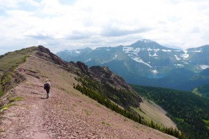
From Carthew Summit the trail descends to the east, where in the far distance you can see the Rocky Mountains suddenly end and the flat plains of the prairies begin. As you descend towards Carthew Lakes on the red rock slopes of Mount Alderson you might feel more like you are walking on Mars. Continue around upper Carthew Lake where snow patches can linger late into the summer, and keep your eyes open for Rocky Mountain Bighorn Sheep and Grizzly Bear as you are walking through their backyard.
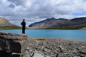
Descend the steep trail from lower Carthew Lake past the cascading outflow from the lake, down a couple switchbacks to Alderson Lake. A short side trail takes you to the shores of this emerald lake set in a huge natural amphitheatre surrounded by mountain peaks on all sides. This is the site of the inviting Alderson Lake campground. 6.5 kilometres from Alderson Lake, the trail ends at Cameron Falls on the western edge of Waterton townsite (1280 m).
Trip-planning:
- Trailhead directions: Take the hiker’s shuttle (free in 2016) from Waterton townsite to Cameron Lake and begin the hike at the Carthew-Alderson trailhead (1660 m).
- Permits: Not required for a day hike.
- Distance: 20 km
- Difficulty: Moderate. The trail is excellent but the elevation gain is significant.
- Elevation gain: 650 m
WEEKEND HIKE: The Summit of the Great Divide – David Thompson Highway to Pinto Lake
Begin at the Owen Creek trailhead just east of the Banff National Park gate on the David Thompson Highway (Highway 11). After a short climb you will come to an incredible slot canyon. Owen Creek has carved a deep ravine that you can straddle and view cascading 30 metres below your feet. A short walk farther will take you back to the banks of the now more placid creek where you can picnic and get great views of the Wilson Icefield.
Continue on up the creek bed, scrambling over boulders and small waterfalls, to the first of three high passes. Cross-country travel across a scree slope brings you to Michele Lakes. Before you head down to the lake, climb the 30 metre berm to the cliffs above the lakes to marvel at Michele Lakes deep aquamarine beauty from high above. Bring a fishing pole to try your luck for the elusive California Golden Trout for which these lakes are renowned.
After a break lakeside, climb to the highest point on the GDT at 2590 metres, where there is a rumour of a bottle of fine Canadian rye whiskey hidden somewhere in the cairn at the top of the lofty pass. Sign the summit trail register and then head down the steep scree to Waterfalls Creek where there is a good campsite before attempting to find the hidden route up the next high pass (look for orange blazes).
From the third pass, it’s an easy trek on good trail down to Pinto Lake. The main campground on Pinto Lake is on the north shore but the best campground is on the south-east shore, where in the morning you can enjoy your coffee watching the sun melt the mist off this almost always serene shoreline. If you are lucky you may find the geo cache from the Calgary Olympics. This was cached over 20 years ago and contains some really neat stuff. It’s near the shoreline at the base of a giant spruce which is broken and burnt from a lightning strike a couple of years ago. Finish the weekend by heading over Sunset Pass back into Banff National Park to the Sunset Pass trailhead on the Icefields Parkway (Highway 93).
Trip-planning:
- Trailhead directions: The Owen Creek trailhead is 6 kilometres east of Saskatchewan River Crossing on the David Thompson Highway, 80 kilometres north of Lake Louise. The Sunset Pass trailhead is 16 km north of Saskatchewan River Crossing on the Icefields Parkway.
- Permits: A National Park Wilderness Pass is required if you plan to camp in Banff National Park (on the Owen Creek trail or the Sunset Pass trail)
- Distance: 40 km
- Difficulty: Difficult. Portions of this route involve cross-country travel (i.e. no trail) so good route-finding skills, and a map and a compass are required.
- Elevation gain: This route climbs 4 high passes with elevation gains of 1065 m, 240 m, 310 m, and 415 m.
BONUS: This trip can be extended by continuing down the Cline River from Pinto Lake to Cataract Creek in the Whitegoat Wilderness. Follow the primitive Cataract Creek trail to its headwaters, passing some ancient pictographs along the way. A steep, cross-country climb will bring you to the top of Cataract Pass where you will cross into Jasper National Park and be treated to amazing 360 degree views of a massive col surrounded by glaciers and waterfalls. Descend from the pass and follow the Brazeau River to Nigel Pass, where a trail junction leads to the trailhead parking lot on the Icefields Parkway. Additional distance: 40 km and one additional pass with an elevation gain of 740 m.
WEEK-LONG HIKE: Meadows and the Matterhorn (of the Canadian Rockies) – Mount Shark trailhead to Sunshine Village via Mount Assiniboine
This trail crosses the continental divide four times and is a wilderness highlight reel of crystal clear alpine lakes, wildflower meadows, and endless views, with the iconic beacon of Mount Assiniboine towering above.
Start from the Mount Shark trailhead (1700 m) and hike 6 kilometres on the Watridge Lake trail to reach the GDT, just inside the Banff National Park eastern boundary in the shadow of towering Cone Mountain. The trail follows Bryant Creek upstream, beginning mostly in the forest but the views improve farther up the valley as the trail breaks into open meadows. 7 kilometres from the Watridge Lake trail junction, turn left (west) onto the Marvel Lake/ Wonder Pass trail. Views just keep getting better as the trail climbs the open slopes above impressive Marvel Lake up to Wonder Pass (2280 m) on the BC-AB border and Banff-Assiniboine park boundary.
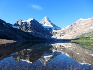
As you descend into Mount Assiniboine Provincial Park from Wonder Pass, the larch trees begin appearing in greater numbers. This area is spectacular in the fall when the larch needles turn gold. Pass by the Naiset Huts (a good place to stay if the weather turns nasty) and stop for afternoon tea at Assiniboine Lodge, soaking up the stunning views of Lake Magog and Mount Assiniboine. Magog campground is about 1 kilometre from the lodge and is a good place to set up basecamp for a couple days to allow yourself time to explore the many side trails in the area, such as Nub Peak or Sunburst and Cerulean Lakes.
After prying yourself away from the jaw-dropping beauty of the core area of Assiniboine, continue your hike through vast alpine meadows to Og Lake with its lakeside campground (a good option if the Magog campground is full). Fill up your water bottles here as it is a long (yet scenic) walk through the Valley of the Rocks and up and over Citadel Pass (2365 m) to the next reliable water source at Howard Douglas Lake. Next to Howard Douglas Lake is the last campground on the trail before reaching Sunshine Village. From the lake you’ll walk through Sunshine Meadows, famously filled with wildflowers in early summer, 6 kilometres to the trailhead at Sunshine Village (2200 m).
Trip-planning:
- Trailhead directions: To get to the Mount Shark trailhead, drive about 40 km south of Canmore on Highway 742 (the Smith-Dorrien Spray Trail) and turn right (west) at the sign for Mount Shark. 5 km down this road is the trailhead parking lot. To get to the Sunshine Village trailhead, take the Sunshine Ski Area exit 9 km west of Banff on Highway 1 and follow Sunshine Road for 9 km to the parking lot. White Mountain Adventures operates a shuttle bus to Sunshine Village from the parking lot or from Banff.
- Permits: A National Park Wilderness Pass is required if you plan to camp in Banff National Park. Campgrounds in Mount Assiniboine Provincial Park are available on a first-come first-served basis. Reservations are recommended if you plan to stay in the Naiset Cabins near Assiniboine Lodge.
- Distance: 50 km
- Difficulty: Moderate. Excellent trail with two high passes.
- Elevation gain: This route climbs 2 high passes with elevation gains of 580 m and 430 m.
