
Effective immediately, the GDTA is announcing a couple changes to the main route of the GDT as well as an Alternate Southern Terminus due to the trail closures in Waterton Lakes National Park. These new routes are reflected in the GDTA map and GDT App.
Alternate Southern Terminus (Section A)
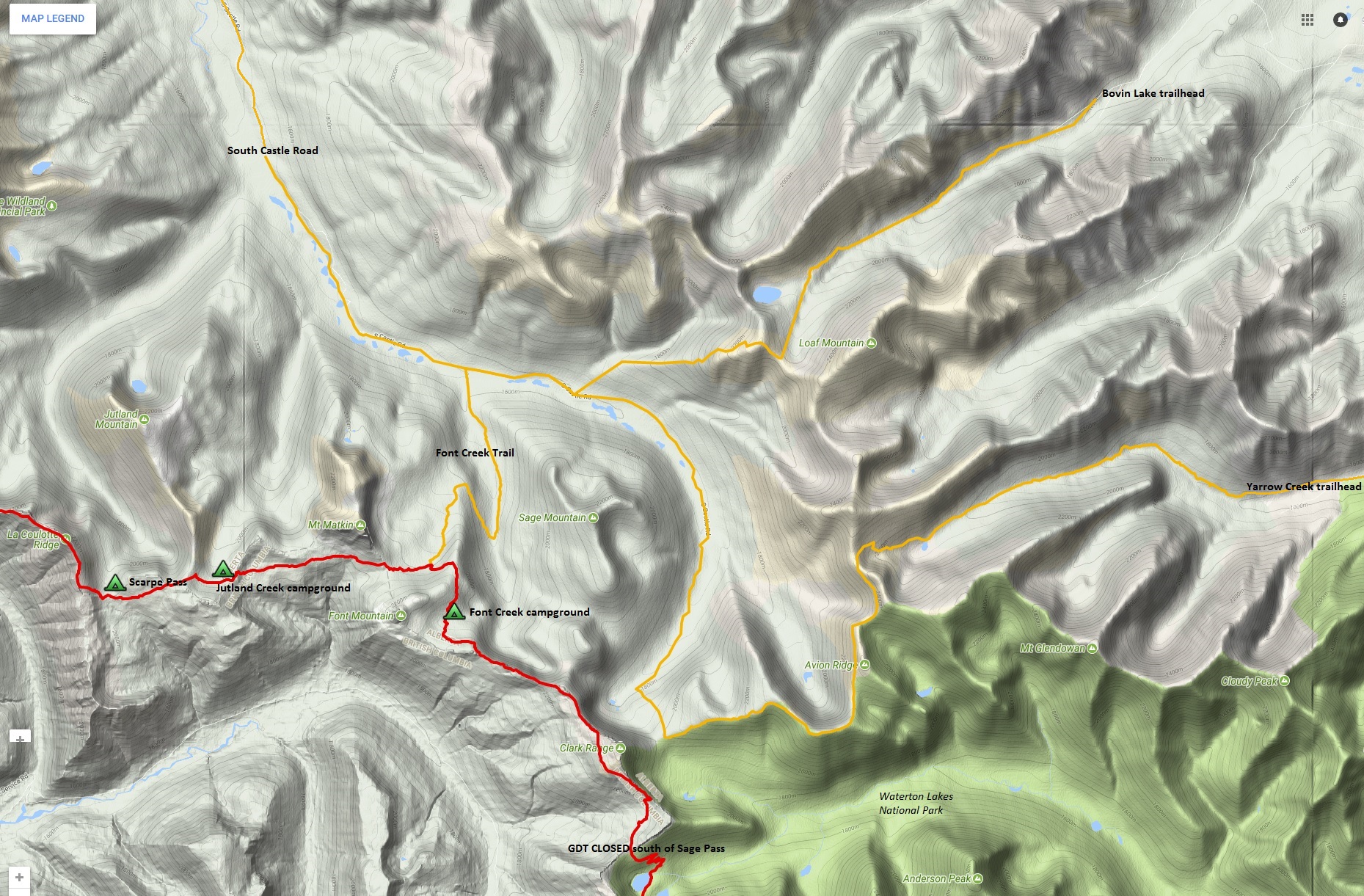 Sadly it looks like the GDT in Waterton Lakes National Park will not re-open in 2018 due to the extensive damage from last year’s Kenow wildfire so this means that Font Creek Trail will be the Alternate Southern Terminus of the GDT this year. We continue to monitor the situation closely and will provide updates as information becomes available.
From the South Castle Road, Font Creek Trail immediately fords the South Castle River and ascends 400 metres over 5.9 km to connect with the GDT about 1.6 km north of Font Creek campground (a19). There are 3 different approaches to reach Font Creek Trail giving hikers a few options to explore. All trailhead/staging areas are 2WD accessible:
- Bovin Lake (aka Blue Lake) Trail – RECOMMENDED OPTION – 13.5 km on good multi-use trail. Bovin Lake trailhead is accessed via Township Road 43A, Range Road 303 & 302B, 38 km south of Pincher Creek. 6 km down the trail, about 1 km before Bovin Lake you will hit a trail junction heading south up the ridge above the lake. Take this trail up and over the ridge and descend to South Castle Road about 2 km east of Font Creek Trail.
- South Castle Road – 23 km walk on the old road to Font Creek Trail. The “trailhead” / staging area is 37 km southwest of Pincher Creek near Beaver Mine Lake via Highway 507 & Road 774. Beyond this point, South Castle Road is closed to regular vehicles and will likely be closed to OHVs later this year.
- Yarrow Creek-Avion Ridge Trail – 30 km mostly on good trail with some spectacular ridge-walking. Accessed via Township Road 44 & Range Road 303, 41 km south of Pincher Creek. The trailhead is located at the end of a deadend spur off of Range Road 303 past a junction with a gated private road. Follow the trail around the ridge and cross Yarrow Creek to connect with the road. Follow the road for about 2.5 km to the last Shell Compressor station where you will find the Yarrow Creek Trail on the far/west end of the clearing. Follow this trail for 6.4 km to reach a small lake at the head of Yarrow Creek. From the lake look for a trail leading west up through the trees and grass near the outflow of the lake. The first part of the trail has been washed away creating a large ditch. Keep hiking up and you will hit good trail which makes a couple switchbacks in shale before reaching the Spionkop-Newman col at the top of the ridge also known as Big Horn Pass. From here follow the trail that traverses below Newman Peak to reach Avion Ridge. Follow the Avion Ridge Trail to South Castle Pass where you will connect with a trail that descends to the South Castle Road about 9 km south of Font Creek Trail.
Moose River Re-Route (Section F)
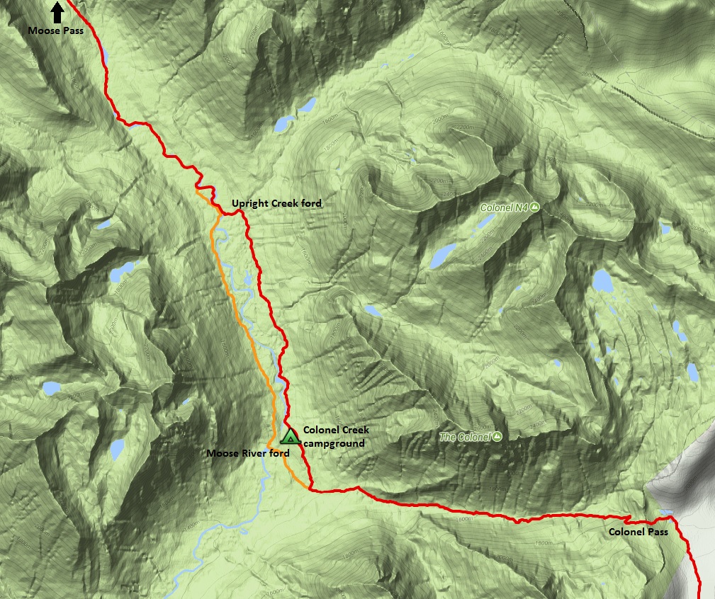 Following trail work in 2016 & 2017, the GDT once again travels on the east side of the Moose River from Colonel Creek trail junction (f11) to just past the ford of Upright Creek. Colonel Creek campground has also been cleared and re-opened. The route on the west side of the Moose River can still be used as an alternate, recommended more for equestrian use due to the challenging Moose River ford.
Jackpine Alpine Re-route (Section G)
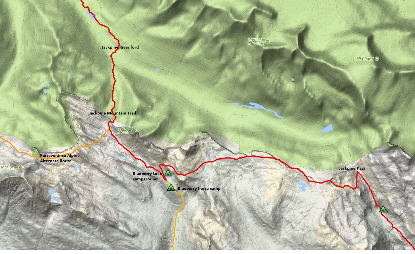 From Jackpine Pass (g5), the GDT now follows the high alpine route until it reaches a junction with the Jackpine Mountain Trail (g7), which it then descends down to a well-marked ford of the Jackpine River (g8) where it reconnects with the Jackpine River valley route. Almost half of the 17.8 km Jackpine Alpine Re-route is cross-country marked only with the occasional cairn but the route finding is straight forward and the views are spectacular. 10.5 kilometres west of Jackpine Pass you will reach a junction with the Blueberry Trail (g6) and the nearby Blueberry Lake campground. The Blueberry horse camp is reached 400m down the Blueberry Trail and the Holmes River Road is reached in 7 km at a point that is about 45 km from Highway 16. From the Blueberry junction, the GDT follows fairly good trail marked with cairns and orange blazes to an unmarked junction with the Perseverance Alpine Alternate Route and the Jackpine Mountain Trail (g7). From this point, hikers have the option of continuing cross-country on the alpine route or descending 4 km on the trail to the valley bottom, noting that the alpine route is longer and gets considerably more challenging west of this junction.