

International Boundary to Coleman
| Suggested start/finish | Waterton Townsite and Coleman |
| Recommended number of days for section | 8 (relaxed), 7 (average), 4 (fast) |
| Distance | 145 km |
| Elevation Gain/Loss | 11943m / -11919m |
| Traditional territory of the | Blackfoot Confederacy, Tsuut’ina, Stoney Nakoda, and Ktunaxa |
| National Parks | Waterton Lakes National Park |
| Permits required | Parks Canada Discovery Pass and backcountry camping permits in Waterton Lakes National Park |
| Alternates | Mt Rowe-Sage Pass Barnaby Ridge |

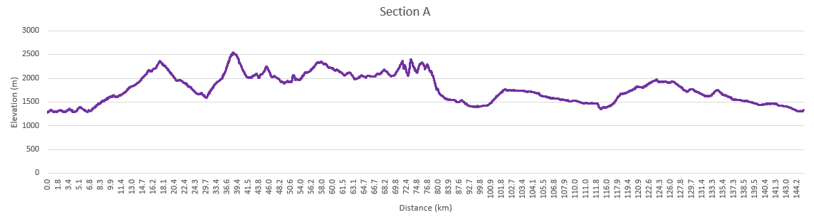
Section A starts on the US-Canadian border and runs north to Highway 3 and the hamlet of Coleman. Section A is one of wild extremes, in that it starts with maintained and popular trails in a national park but also includes what many consider the single hardest day on the GDT – La Coulotte Ridge.
Starting at Boundary Bay on the US-Canadian border where the GDT connects with the Continental Divide Trail in the USA, the GDT heads north through Waterton Lakes National Park in Alberta. In 2017, the Kenow wildfire burned much of the park (thankfully sparing most campgrounds and facilities), but a lot of work has gone into repairing damage and improving things. This does mean you will encounter large burnt sections where there is little shade, and summer days can get hot.
To get to the international border monument marking the start of the trail, most folks will hike from Waterton townsite (and back). It’s only 6 km to the border and can easily be done in a single day. There is also a boat that takes you to Goat Haunt on the US side where you can hike to the start of the trail. This involves an international border crossing and you will require a passport or suitable ID to cross and will need to check-in with both US and Canadian customs. If you are an international traveller, ensure you can enter the US if you choose this option.
The GDT Through Waterton Lakes National Park
Within Waterton Lakes National Park, trails are well maintained and easy to follow. Some portions can be very popular in the summer with day hikers, equestrians, and folks doing a quick overnight. From Boundary Bay, the trail heads north to the Waterton townsite over a few easy mountain spurs. You’re never far from Upper Waterton Lake and water is plentiful. Backcountry campgrounds are available at Bertha Bay and Boundary Bay. The townsite also has full services for lodging, frontcountry camping and resupply.
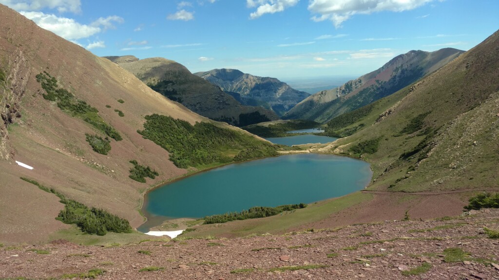
From there it’s up the valley to Carthew Creek, Alderson Lake, and the beautiful Carthew Lakes. The route over Carthew Summit is well marked with wayfinders above treeline. Once over the top, you’ll peer into remote reaches of Glacier National Park in the US and make your way back down to Cameron Lake. Cameron Lake is a busy tourist destination with a small store for refreshments and canoe rentals (last vault privy toilets for a while). Once you reach Cameron Lake, you’ll have two options. The main route remains in Waterton Lakes NP and follows the popular Tamarack Trail, while the Mount Rowe Alternate follows an unmaintained cross-country route on the British Columbia side of the divide. Normally this alternate route is used by folks who are unable to secure permits for campgrounds along the Tamarack Trail or who prefer the option of random camping. Regardless, many will take the option of camping at Akamina Creek on the BC side of the divide as it’s the only place you can camp in this area.
For those following the main route, there is a short section of road walk to the Rowe Lakes trailhead. Through the forest, you’ll make your way up to Rowe Meadows (grab water here) and then climb to the second highest point on the GDT, Lineham Ridge. More wayfinders mark the route. Several saddles through the burned Blakiston valley take you past campgrounds at Lone and Twin Lakes and up to Sage Pass where you leave Waterton Lakes National Park.
The Mount Rowe alternate takes you steeply up to the divide on an unmaintained route for 18 km. While shorter, the alternative isn’t a time saver and you’ll be walking a thin line of open terrain between steep cliffs and thick brush. Scenery is spectacular, but not an alternate for bad weather days, or if you’re still earning your trail legs. Load up with water before taking the Mount Rowe Alternate as there are no reliable water sources available en route.
Campgrounds in this area:
- Boundary Bay – Waterton Lakes National Park (reservation and permit required)
- Bertha Bay – Waterton Lakes National Park (reservation and permit required)
- Waterton Townsite (Frontcountry) – Waterton Lakes National Park (reservation and permit required)
- Alderson Lake – Waterton Lakes National Park (reservation and permit required)
- Akamina Creek – Akamina-Kishinena Provincial Park (first come first served)
- Lone Lake – Waterton Lakes National Park (reservation and permit required)
- Twin Lakes – Waterton Lakes National Park (reservation and permit required)
Entry / Exit Points
- South – Waterton Townsite
- North – Red Rock Parkway via Twin Lakes / Snowshoe Trail
Resupply
- Waterton Townsite
Toward Castle Mountain and the Infamous La Coulotte Ridge
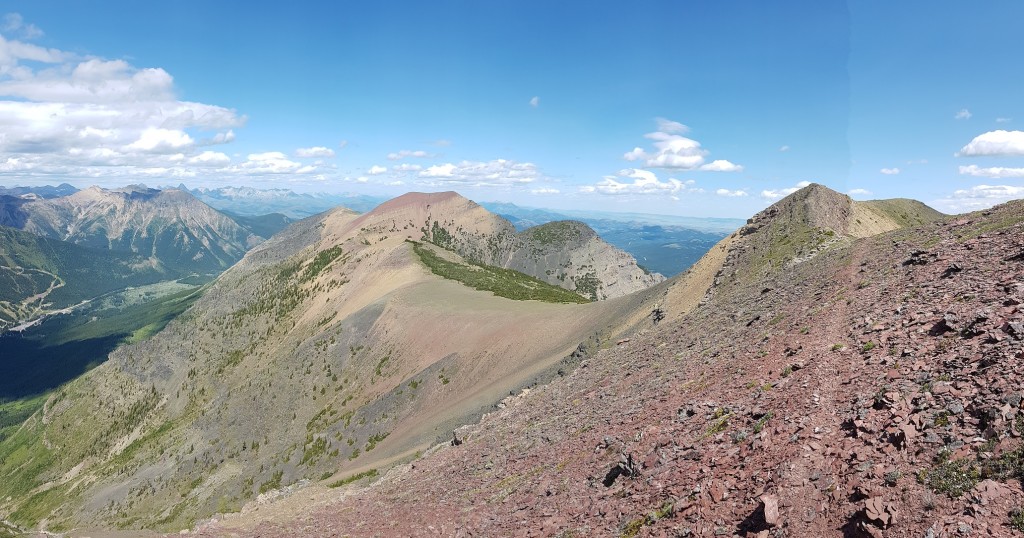
At Sage Pass, the Mount Rowe alternate and main route converge, leaving Waterton behind and straddling the divide between Castle Wildland Provincial Park in Alberta and forestry land in BC. Random camping is allowed throughout, but there are several rustic campgrounds you can use. The trail here is primitive and spectacular, covering several peaks and ridge walks. Quality ranges from “easy to follow” to “route finding”. You’ll encounter what many consider the most difficult day on the entire GDT on La Coulotte Ridge. You’ll want to load up on water at Scarpe Pass (particularly if you’re taking the Barnaby Ridge Alternate) and wait out any inclement weather. Do not underestimate this day.
At La Coulotte Peak, the trail splits between the main route and the Barnaby Ridge Alternate. After one more steep climb, the main route drops down into the West Castle River valley along some ATV trails and Highway 774. Barnaby Ridge remains up high and has spectacular scenery, however there is some scrambling and exposure, and water is limited. It should not be attempted in poor weather. Work has been done to route the trail around the hairiest terrain and flagging and chains have been added. Many will climb down to Grizzly Lake for water and to stay the night. This alternate does bypass the Castle Mountain Ski Resort which can be reached along the main route. Some use the ski resort as a place to mail resupply boxes (call ahead to ensure they are accepting them). There is a restaurant (check hours), but no store to buy supplies.
Campgrounds in this area:
- Sage Pass – BC Forestry (random camping)
- Font Creek – Castle Wildland Provincial Park (random camping)
- Jutland Creek – Castle Wildland Provincial Park (random camping)
- Scarpe Pass – Castle Wildland Provincial Park (random camping)
- Grizzly Lake (Barnaby Ridge Alternate) – Castle Wildland Provincial Park (random camping)
- Barnaby Lake (Barnaby Ridge Alternate) – Castle Wildland Provincial Park (random camping)
- West Castle Road – Castle Wildland Provincial Park (random camping)
- Castle Mountain – Castle Mountain Ski Resort – campground and hostel (reservation required)
Entry / Exit Points
- South – Red Rock Parkway via Twin Lakes / Snowshoe Trail
- North – Alberta Highway 774
Resupply
- Castle Mountain Ski Resort (limited)
On to Coleman

After some initial road walking, the trail moves through an area crisscrossed with old forestry roads, OHV tracks, and seismic lines. The trail can be confusing in parts, and it’s generally not well signed. The terrain itself is not particularly challenging, but you’ll want your maps and GPS to help navigate. At kilometre 129.7, the trail branches with the main route heading to the small hamlet of Coleman on Highway 3. Coleman was a mining boomtown in the first half of the 20th century but doesn’t have a lot of services today. There is a post office to send resupply boxes, and a few restaurants, B&Bs and motels.
An alternate route takes you down a road to the larger town of Blairmore. Here you can find a grocery store, outdoor store, campground, motels and other services for resupply. From Blairmore it’s a 4 km walk to Coleman and the start of Section B.
Campgrounds in this area:
- Lynx Creek – Castle Provincial Park (permit required)
- Willoughby Ridge – Castle Provincial Park (random camping)
Entry / Exit Points
- South – Alberta Highway 774
- North – Alberta Highway 3
Resupply
- Coleman
- Blairmore (off trail)
Notes for Section Hikers
Section A is a challenging introduction to the GDT. Waterton to Coleman makes the most sense as a section hike, although hikers with access to multiple vehicles to set up shuttles may prefer to hike Waterton to Castle Mountain, or Castle Mountain to Coleman. This allows for a more relaxed schedule. For a current list of businesses providing shuttles and transport, see the Access page.
Waterton Lakes National Park can be busy, and while reservations are less challenging than on the Rockwall or Skyline trail, hikers will still need to plan to book on the day permits open to ensure a spot. Most thru-hikers will start at Waterton around July 1st. If you are section hiking, consider a start date that is not early July. This will reduce impact on the trail, and will make it easier for you to book campsites. There is more information on Waterton Lakes National Park Permits here.
Outside of Waterton Lakes National Park, Section A is quiet, and hikers are unlikely to have to worry about competition for campsites.
Cameron Lake and Akamina Campground have had problem bears several years in a row. While travelling through or camping in this area, please make sure you practise good bear safety. The comments in FarOut and the GDT Facebook group are useful for staying up to date with current trail conditions, including animal encounters.
There are no difficult river crossings in Section A under normal conditions.
La Coulotte Ridge is one of the most challenging sections of the GDT. Hikers should be prepared for a long day of very slow travel with no available water sources. The route does not improve after La Coulotte Peak until hikers reach a disused logging road. Hikers should be extremely cautious during bad weather – there is no shelter on the ridge. In warm weather, hikers should carry plenty of water – there is no water on the ridge and snow patches to melt may not be available depending on time of year.

Suggested Itinerary
This itinerary is based on the relaxed schedule on the GDTA itinerary page.
| Night | Campground | Notes | Daily Walking Distance (km) | GDT Total Distance (km) |
| 1 | Alderson Lake (Waterton Lakes NP) | Walk to border and back, then to camp | 19.1 | 12.9 |
| 2 | Akamina Creek (Akamina PP) | 2.4 km off route | 14.8 | 25.3 |
| 3 | Lone Lake (Waterton Lakes NP) | 22.8 | 45.7 | |
| 4 | Jutland Creek (Castle Wildland PP) | 20.4 | 66.1 | |
| 5 | West Castle Road (Castle Wildland PP) | Very difficult travel on La Coulotte Ridge | 14.4 | 80.5 |
| 6 | Random Camp along OHV road around km 105 (Castle PP) | Easy travel | 24.5 | 105 |
| 7 | Haven’s Bridge | Easy travel | 29.1 | 134.1 |
| 8 | End in Coleman | Short day into town | 10.7 | 144.8 |
Photographs
Photographs courtesy Mike Hopkins, Brad Vaillancourt, Joan Pendleton, Steve Harvey and Eloise Robbins


