

North Saskatchewan River Crossing to Jasper
| Suggested start/finish | The Crossing Resort to Jasper |
| Recommended number of days for section | 11 (relaxed), 8 (average), 5 (fast) |
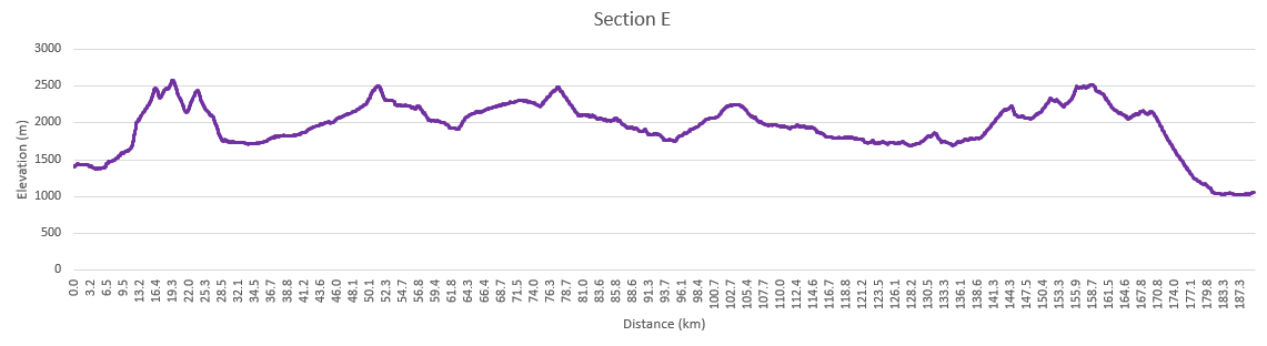
| Distance | 190 km |
| Elevation Gain/Loss | 12375m / -12720m |
| Traditional Territory of the | Tsuut’ina, Stoney Nakoda, Cree, Ktunaxa, Secwépemc, and Métis |
| National Parks | Banff and Jasper National Parks |
| Permits required | Parks Canada Discovery Pass and backcountry camping permits in Jasper National Park, Alberta Public Lands Camping Pass |

“It was the best of times, it was the worst of times”. Section E on the Great Divide Trail is a study in contrasts. The stretch between Saskatchewan Crossing and the town of Jasper passes through remote areas of White Goat Wilderness Area and the overgrown trails of the Maligne Valley. At the same time it also traverses the highest point on the GDT and the extremely popular Skyline Trail and Jonas Shoulder sections of Jasper National Park. If you love hiking above the treeline, Section E is for you!
Owen Creek
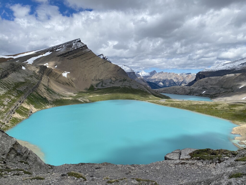
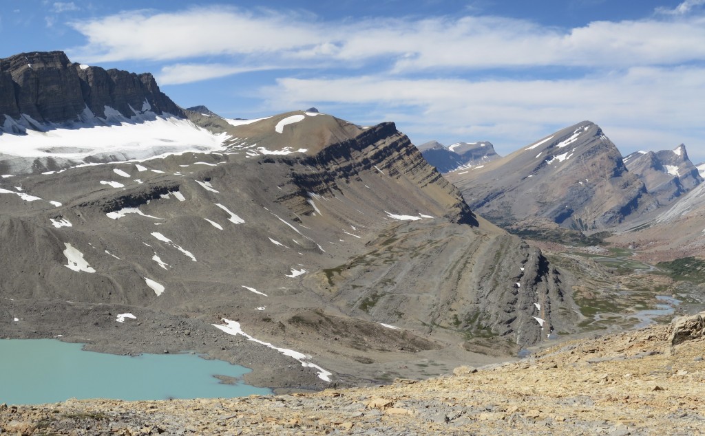
Leaving the resort at Saskatchewan Crossing, there is a short section of road walking along the David Thompson Highway. From the Owen Creek trailhead you’ll start your climb. The trail here is unmaintained and can be hard to follow. The creek quickly turns into a canyon as you struggle your way up to Owen Pass and treeline. For the next 18 km you’ll parallel a stunning rock wall through the alpine and pass by Michele Lakes, the prettiest lakes on the GDT, to reach the highest point on the GDT at 2585m.
Campgrounds in this area:
- Michele Lakes – Random camping (Alberta Public Lands Camping Pass required)
- Waterfalls Creek – Random camping (Alberta Public Lands Camping Pass required)
- Pinto Creek – Random camping (Alberta Public Lands Camping Pass required)
- Pinto Lake East – Random camping (Alberta Public Lands Camping Pass required)
- Pinto Lake North – Random camping (Alberta Public Lands Camping Pass required)
- Cataract Creek – White Goat Wilderness Area random camping (no permit required)
- Cataract Pass – White Goat Wilderness Area random camping (no permit required)
Entry / Exit Points
- South – Highway 11
- North – Highway 11 via Waterfalls trail
Resupply
- None
Height of the Canadian Rockies
One thing that surprises a lot of people who have seen the towering peaks of the Canadian Rockies, is their height when compared to the Colorado Rockies or Sierra Nevada mountains. There are no 14ers (4267m) in Alberta or eastern BC, with the highest mountain in the range being Mount Robson at 3954m (12,972 ft). What makes the Canadian Rockies different is during the last ice age, glaciers carved out the valleys making the mountains much more prominent. The northern latitude and shorter glowing season also pushes down the treeline, making it 450-750m lower than Colorado. Combined, these makes it seem like the mountains are much higher. On the plus side, this reduces the risk of altitude acclimatization as you’ll never be over 2590m (8,500 ft).
Up to Cataract Pass
After heading over 3 high mountain passes, the trail drops back into the trees around Pinto Lake. You can exit the trail here by way of Sunset Pass which takes you to the Icefields Parkway. The thru route takes you into the White Goat Wilderness Area where trail maintenance is not allowed (hence the many fallen trees across the trail). The route travels up the long Cataract Creek valley to lofty Cataract Pass on the border of Jasper National Park. Along the way you’ll have a chance to see ancient pictographs. Over Nigel Pass the GDT joins the well maintained (and more crowded) trails of the Brazeau Loop. Back into the alpine, Jonas Shoulder offers spectacular views of the valley, however as the trail heads north, it becomes less travelled and once you pass the Poboktan Creek junction (another exit to the highway), the trail is infrequently maintained.
Campgrounds in this area:
- Boulder Creek – Jasper National Park (permit and reservation required)
- Four Point – Jasper National Park (permit and reservation required)
- Cline (off route) – Jasper National Park (permit and reservation required)
- Jonas Cutoff – Jasper National Park (permit and reservation required)
- McCready Horse Camp – Jasper National Park (permit and reservation required)
- Waterfalls – Jasper National Park (permit and reservation required)
- Poboktan – Jasper National Park (permit and reservation required)
Entry / Exit Points
- South – Highway 11 via Waterfalls trail
- Mid – Highway 93N via Sunset Pass trail
- Mid – Highway 93N via Nigel Pass trail
- North – Highway 93N via Poboktan Trail
Resupply
- None
Maligne Valley
Reaching the vast Maligne Pass, the GDT heads down the valley into forest and several un-bridged creek crossings. Folks have reported that this section of trail has started to deteriorate with GDT hikers being the only ones to really use it, but recent efforts by the GDTA and the Friends of Jasper trail crews have improved the trail somewhat. As the Maligne Pass Trail passes through sensitive caribou and grizzly bear habitat, Parks Canada limits access to the campgrounds in the Maligne Valley. It’s important to adhere to these restrictions and have the appropriate permits to ensure this section of trail remains open to hikers. Note the popular Six-Passes Alternate Route is closed to overnight use due to similar concerns of overuse in sensitive habitat areas.

Campgrounds in this area:
- Mary Vaux – Jasper National Park (permit and reservation required)
- Mary Schaffer – Jasper National Park (permit and reservation required)
- Trapper Creek – Jasper National Park (permit and reservation required)
Entry / Exit Points
- South – Highway 93N via Poboktan Trail
- North – Maligne Lake
Resupply
- None
Enter the Skyline
The path brings you to the popular tourist area of Maligne Lake. Shuttles are available here to Jasper. There is a small gift shop, a lake tour and café. Maligne Lake is also the start of the extremely popular Skyline Trail. Spending most of its time in the alpine, people from around the world come to Jasper just to hike Skyline. Permits can be hard to get, so some GDTers will hike the 40+km in a single day, or divert to Watchtower campground which is a bit off trail. A few popular tourist trails lead you from the end of Skyline and into the town of Jasper and the end of Section E.
Campgrounds in this area:
- Evelyn Creek – Jasper National Park (permit and reservation required)
- Little Shovel – Jasper National Park (permit and reservation required)
- Snowbowl – Jasper National Park (permit and reservation required)
- Watchtower (Off Trail) – Jasper National Park (permit and reservation required)
- Shovel Pass Lodge – Shovel Pass Lodge (reservation required)
- Curator – Jasper National Park (permit and reservation required)
- Tekarra – Jasper National Park (permit and reservation required)
- Signal Mountain – Jasper National Park (permit and reservation required)
Entry / Exit Points
- South – Maligne Lake
- North – Jasper
Resupply
- Jasper


