The Collector’s Edition of Tales from the Great Divide, the compilation of stories about the history of Canada’s Great Divide Trail and the Great Divide Trail Association was launched at the GDTA’s AGM in Calgary in September 2019. By mid-November, all thirty copies had been sold. Jenny Feick, the book’s compiler and editor, supported by Jeff Gruttz, Dave Higgins, Mary Jane Kreisel and Lani Smith and desktop publisher Louise Beinhauer have been busy preparing a Second Edition that will be published this spring. The Second Edition will correct errors found in the first edition and add new material.It will be available in both print and pdf form. Anyone who purchased the Collector’s Edition will receive a pdf of the Second Edition.
If you are interested in purchasing a copy of the Second Edition of Tales from the Great Divide, Vignettes on the Origins and Early History of Canada’s Great Divide Trail and the Great Divide Trail Association, please contact Jenny Feick at jenny.feick@gmail.com.
If you would like to view a copy of the Collector’s Edition, check the GDTA archives at the University of Calgary in the new Glenbow Western Research Centre, which is on the second floor of the Taylor Family Digital Library within the Archives and Special Collections. The reading room is open weekdays between 10:00 am and 4:30 pm and the curator is Annie Murray.
At every AGM, we thank departing Board members for their contributions, re-elect members that desire to serve another 3 year term and welcome new Board members.
This year, we say thank you to four Board members who are not returning to the Board. Each of these four individuals made significant contributions to the GDTA over their three year terms and for that we say thank you! The retiring Board members are: Barb Lauer (Outreach and Engagement), Darrell Aunger (Organizational Design), Dave Hockey (President) and Jean-Francois Cianci (Grants and Marketing).
Two existing Board members were re-elected:
Brad Vaillancourt, President
Brad Vaillancourt thru-hiked the entire Great Divide Trail in 2006, and hasn’t stopped being involved with the trail ever since. When the GDTA was re-activated in 2013, Brad served as the organization’s president until 2016. From 2016 until present, Brad continues to serve on the GDTA Board of Directors, resuming the role of President in 2019. Brad’s various responsibilities with the GDTA have included being the lead for the GDT in BC, planning and implementation of the GDT Management Plan, design and maintenance of the GDTA website, development of GDT hiker resources, managing GDTA membership, chairing the Trail Building & Maintenance Committee, and leading at least one annual trail maintenance trip per year. Brad is very proud how much the organization has accomplished and grown in the past 6 years and is excited for the future of the Great Divide Trail.
Jeff Gruttz, Chair
Jeff was a founding member of the GDTA in 1975 and served with the Board until 1983. From 1978 to 1980, he participated in field planning & crew coordination involving trail construction between North Fork and Fording River Passes. Jeff earned a MSc from the University of Calgary with thesis on hikers’ impact on day use trails in Yoho National Park. He retired from 22½ years with City of Calgary Parks as an Outdoor Coordinator and Liaison and has volunteered on the Alberta TrailNet Board for 12 years. Jeff received the 2003 Alberta TrailNet “Trailblazer” award and his passion is ‘doorstep accessibility’ to walking and bicycling opportunities everywhere. Jeff participated in most of the ‘Friends of GDTA’ multi-day volunteer work parties held in the 2000’s, and he continues to participate in trail building and maintenance trips as often as he can. Jeff has been a GDTA Board member since the GDTA re-incorporated in 2013.
Two new members were elected to the Board:
Chase Holthe, new Director
Growing up on a farm in Taber, Alberta, Chase has enjoyed a lifetime of hiking, camping, horseback riding, and similar outdoor activities. The Great Divide Trail cuts through an area in the Crowsnest Pass with which he is very familiar and have many fond memories. Chase has practiced as a corporate disputes lawyer since being called to the Alberta Bar in 2012.Working at Norton Rose Fulbright Canada LLP, one of the world’s largest firms, has given him significant experience with corporate governance and problems faced by Boards of Directors.
Robert MacLaine, new Director
Robert has recently graduated from Mount Royal University with a bachelor of Health and Physical Education, a major in Ecotourism & Outdoor Leadership, and a minor in Marketing. He is currently employed as a backcountry guide leading horseback trips in Kananaskis country. The skill set Robert brings to the organization is enthusiasm and passion for outdoor leadership as well as advocacy for conservation and trail development to ensure. His skills developed at MRU with a minor in marketing is an understanding of social media applications, best practices and campaign development. Through the major of Ecotourism/Outdoor leadership he has developed relationships with the ETOL community a group of people with a passion for the outdoors and conservation as well, sustainable development of parks, public lands and tourism attractions. Robert’s work as an outfitter provides him with an understanding of the lands the GDTA works on, through and some of the bureaucratic bodies the association works alongside. His position within the Equine industry also provides a perspective often under represented in outdoor organizations.
2019 was a very busy year for the GDTA, with more scouting, trail building and maintenance trips than ever before. A huge amount was accomplished thanks to the large number of hard-working and dedicated volunteers. Key accomplishments in 2019:
The wettest and coolest summer in the Rockies in decades, but no wildfires!
135 volunteers participated in 12 trail building and/or maintenance trips and 2 scouting trips – the most volunteers and total trips ever in one season!
50 return volunteers from previous trips
54 first-time volunteers, including:
2 instructors and 10 students from the Wild Rockies Field Institute in Montana
2 troop leaders and 8 Junior Forest Rangers from Calgary
4 km of new trail cleared and/or built on the High Rock Trail
13 km of the historic David Thompson Heritage Trail restored + 1 bridge completed
6 km of the Maligne Pass Trail cleared in Jasper National Park
1 km re-built on the Original GDT
June Scouting
The season started with the usual spring scouting trip which we like to hold a week or two before the first work trip, which meant this year’s scouting trip was earlier than usual. Thankfully on our drive in, the scouting team only encountered snow on one short section of the Atlas Road. But this still took most of the day to dig and push our way though. The snow increased higher up and we could not drive all the way up to the intended camp spot so we improvised and set up camp at “Winch Creek” just before dark. The next day scouting higher up was not possible due to 1 metre of snow, so we concentrated lower down and spent a good amount of time scouting future work camp locations. The time spent on fine tuning the route was well worth it.
Late Spring in the Canadian Rockies
Trips #1-3 – High Rock Trail, June 13 to 27
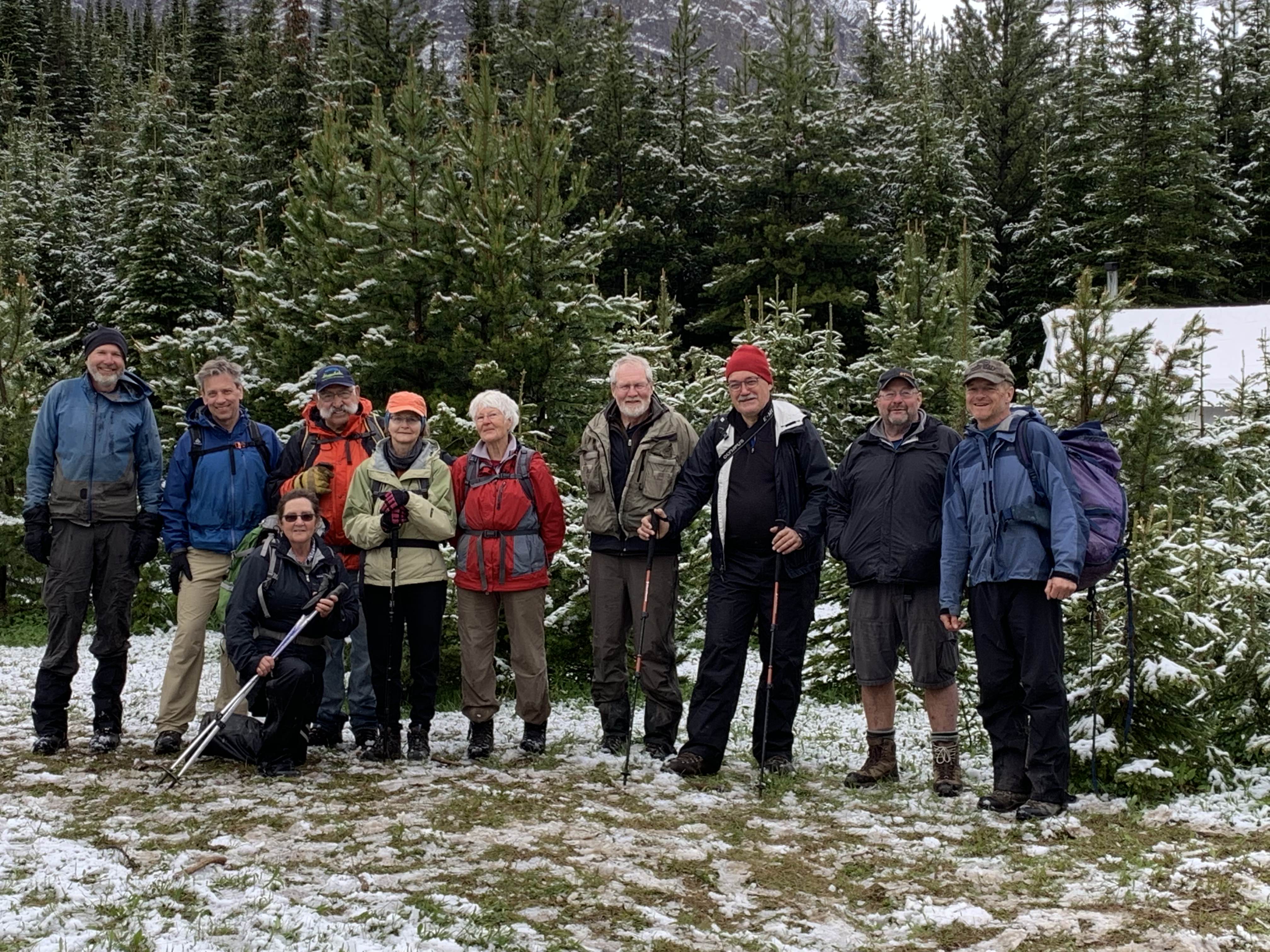
By June 13, snow was no longer an issue, amazing what two weeks does. Day 1 was warm and sunny. Equipment and supplies for our base camp for Trips 1-3 was shuttled in to First Creek Road via ATV while the crews walked in on foot. The weather started great but we had some unusually cold and rainy days, one day of snow and one day with some intense lightning. Overall things still worked out, but we shortened some work days as the cold and rain drained people’s energy and made the terrain very slippery. Even though the weather didn’t always cooperate, we had a lot of experienced volunteers on the first three trips which allowed us to make good progress.
GDTA Volunteers (in the snow)
These first three trips involved building trail tread up a steep slope as well as brushing and chainsaw work. Over the 2 weeks, we completed 1.4 km of new tread, completing all brushing and chainsaw work in the area. This year each trip had volunteers responsible for leading duties like latrine, firewood, food storage, etc. and it worked out better than we could ever have imagined. Volunteers really took ownership of their responsibilities and it reduced the demand on the trip leader, resulting in a very well run and enjoyable camp for all.
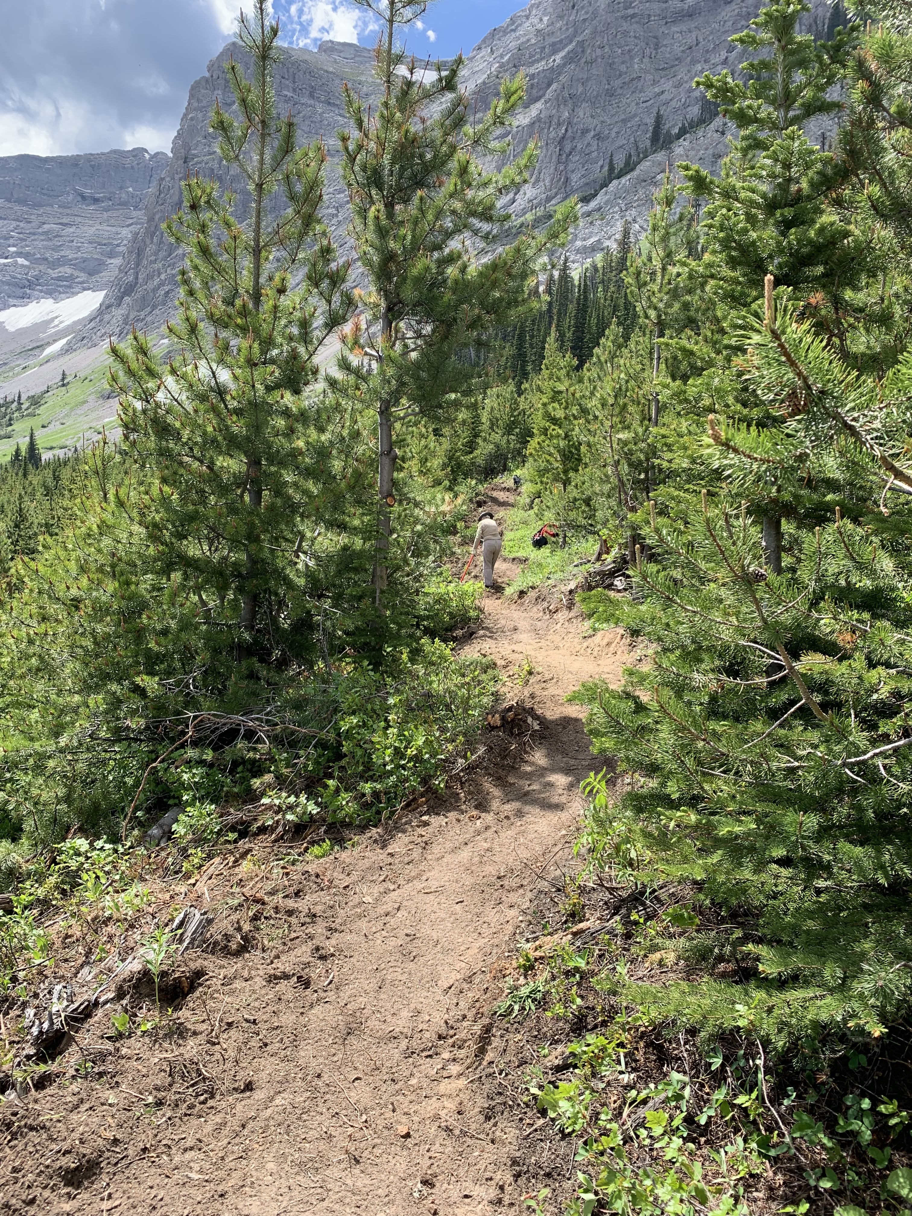
Tread building (on steep slope)
Trips #4-7 – High Rock Trail, June 27 to July 19
These trips had a slightly different makeup with most of the crews being first time GDTA volunteers. Enthusiasm was high as trip leaders taught new volunteers safety procedures and trail construction techniques as tread building was the focus of these trips. As always, there was a significant focus on safety including our new and improved tailgate meetings to begin each day. Things worked out very well even though more rain and cold weather continued throughout. As tread building progressed on Section G, the slope got steeper and thus more attention to detail was needed to make the proper tread width safely on the difficult terrain. Volunteers worked hard in some nasty weather as high winds also become a factor both at the work site and in camp.
Tread building (through the forest)
A group from Montana’s Wild Rockies Field Institute joined us for a few days and they came in with youthful energy and amazing work ethic. With their help, we finished the tread to the top of Section G, achieving one of our objectives for these trips.
Wild Rockies Field Institute Trail Crew
On July 9, our base camp was moved to a new location on the Atlas Road near the access to Window Mountain Lake. This was a learning experience as it was our first time moving camp between trips, involving a lot of work by only a few volunteers. The new base camp featured some serious ingenuity, where we built a solar-powered water pump to get water from the nearby creek which was down a steep ravine. The new camp was used for the next 4 trips including the Signature Trip.
Tread building (through an old clearcut)
Weather continued to be a challenge with more rain and unseasonably cold temperatures. But our volunteers persevered and built tread on Sections Q and S which thankfully featured much gentler slopes than Section G making trail construction easier and faster. During these 3 weeks, we completed an additional 1.4 km of new tread, connecting several sections of the High Rock Trail.
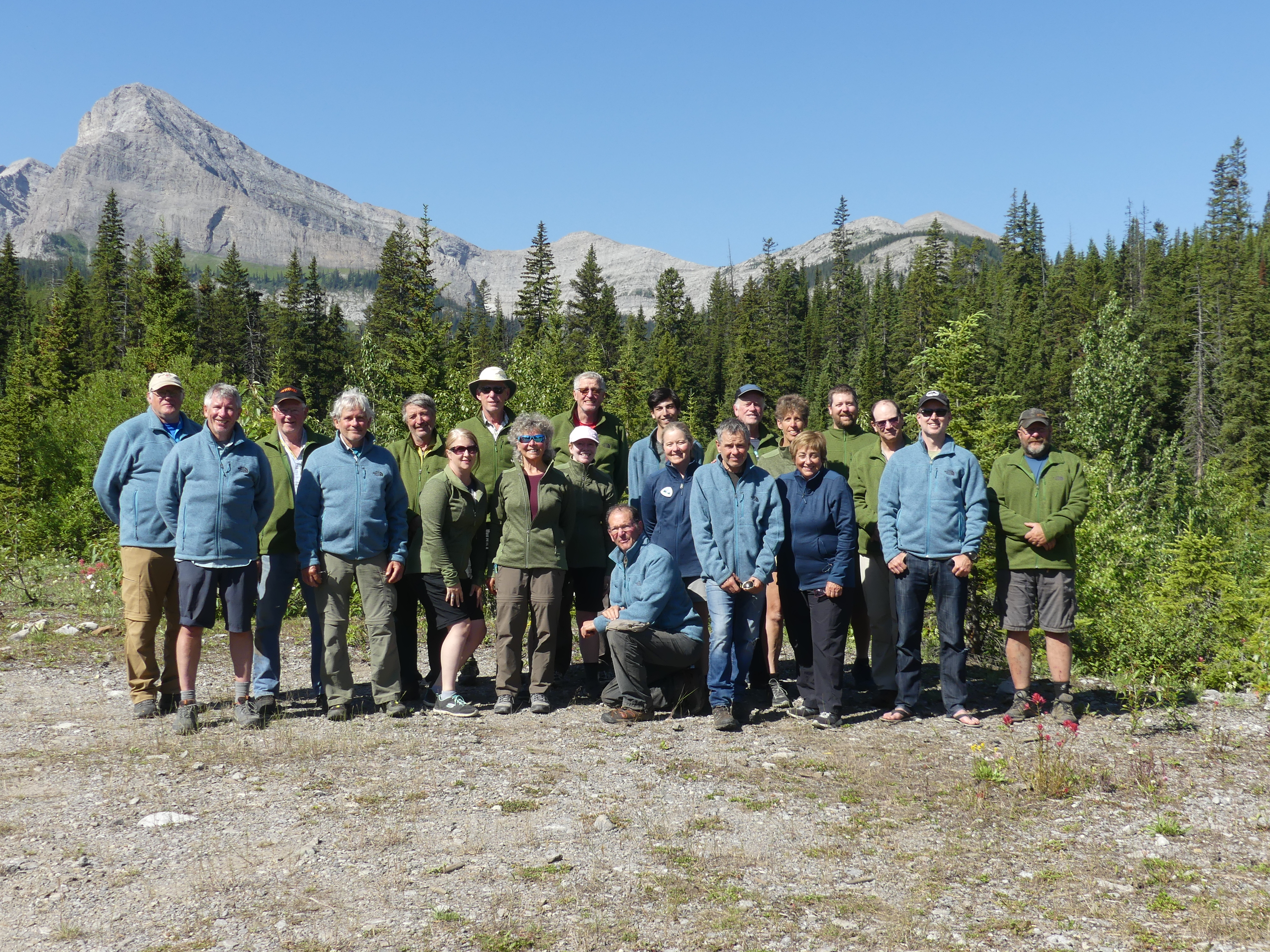
Trip #8 – High Rock Trail Signature Trip, July 19-23
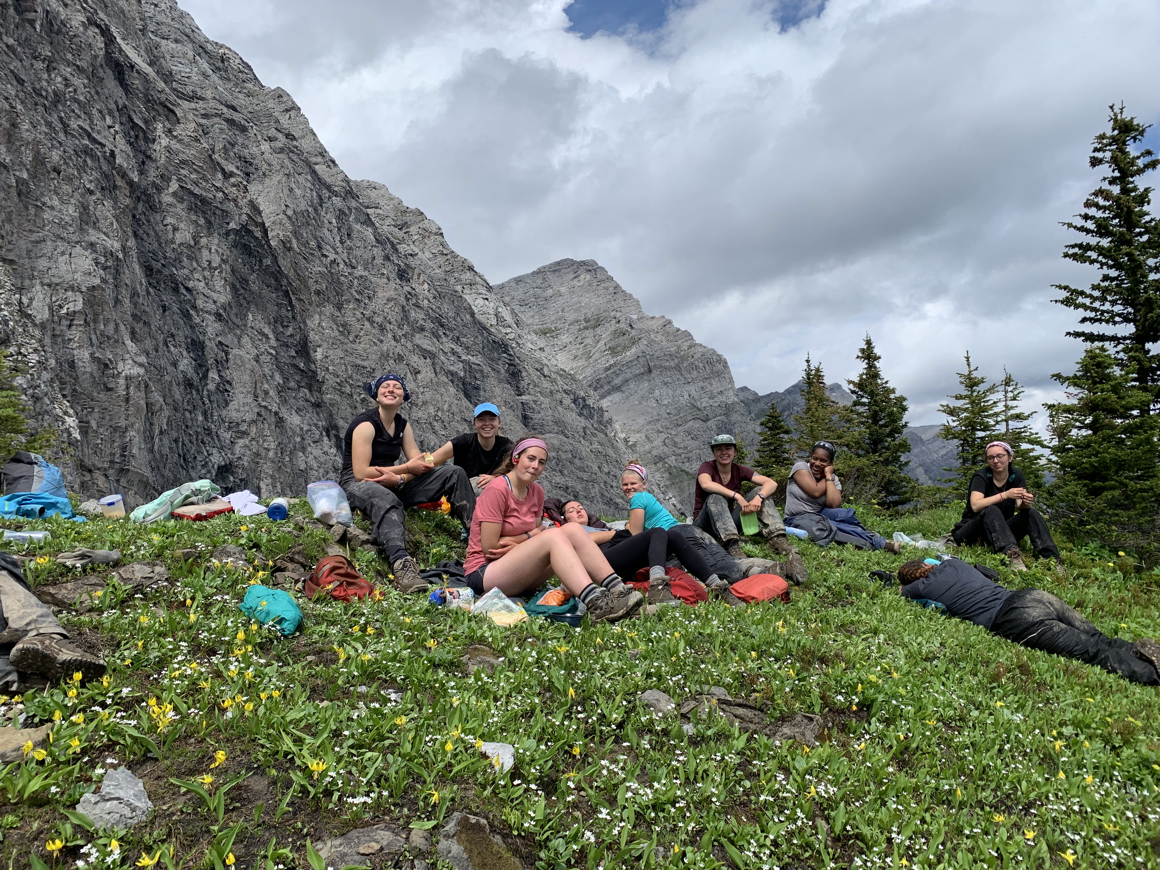
This trip had maybe the most experienced crew ever with all but one of the 20 volunteers having had participated on at least one previous trail building or maintenance trip, including 5 of the Original GDT scouting crew from 1974.
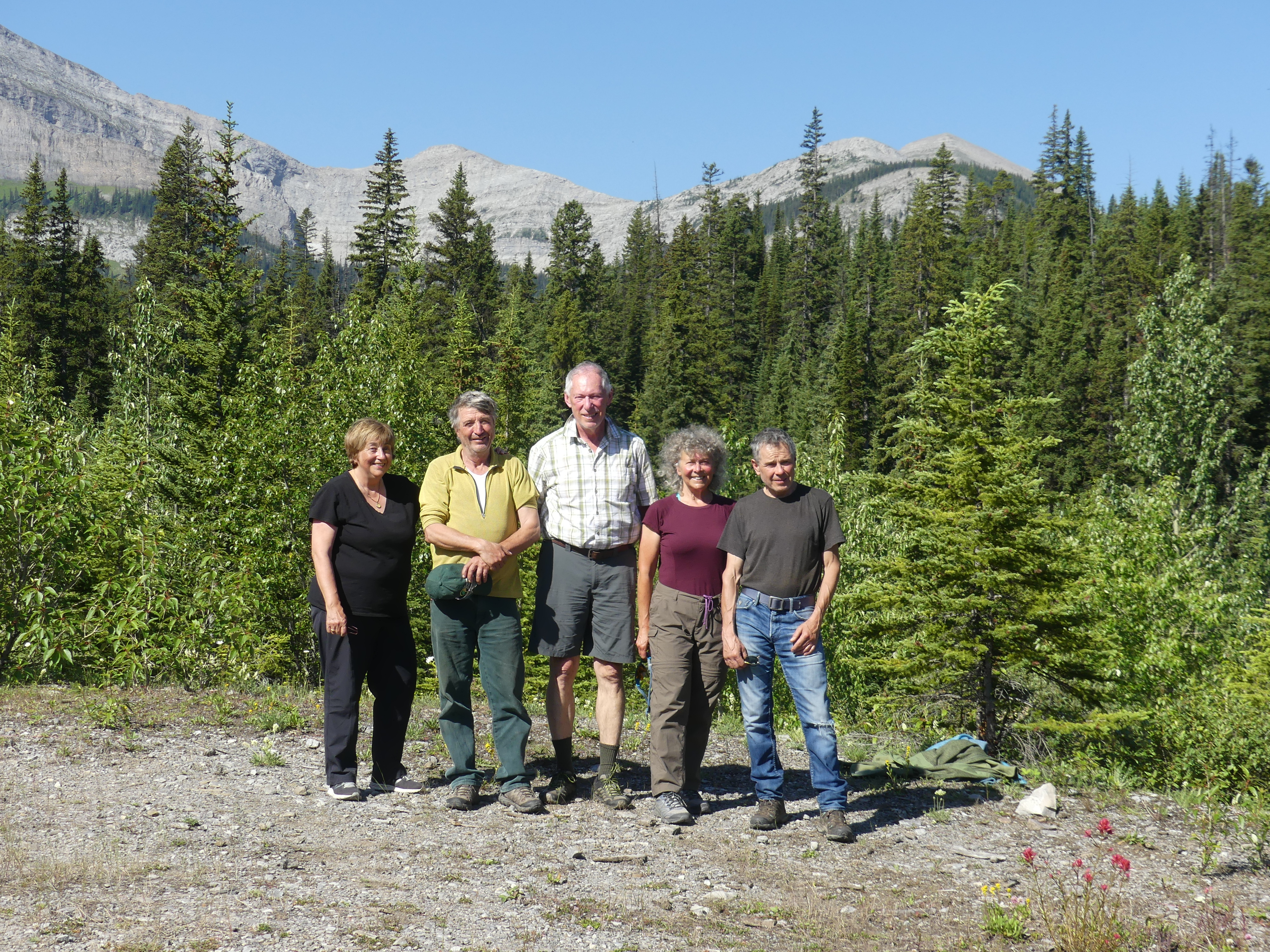
Original GDT’ers (left to right): Mary Jane Kreisel, Cliff White, Dave Higgins, Jenny Feick, Dave Zevick
Many stories of the early days of the GDT were shared each night around the campfire, including a song or two.
Songs around the campfire
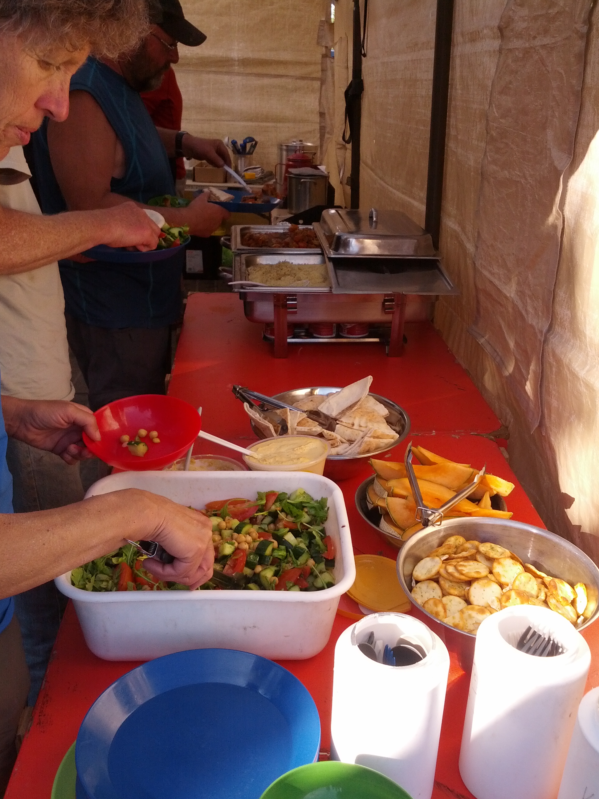
As always on Signature Trips, all food is provided and meals were prepared by Marty, our experienced head chef extraordinaire and his assistant Mary Jane.
Signature Trip food
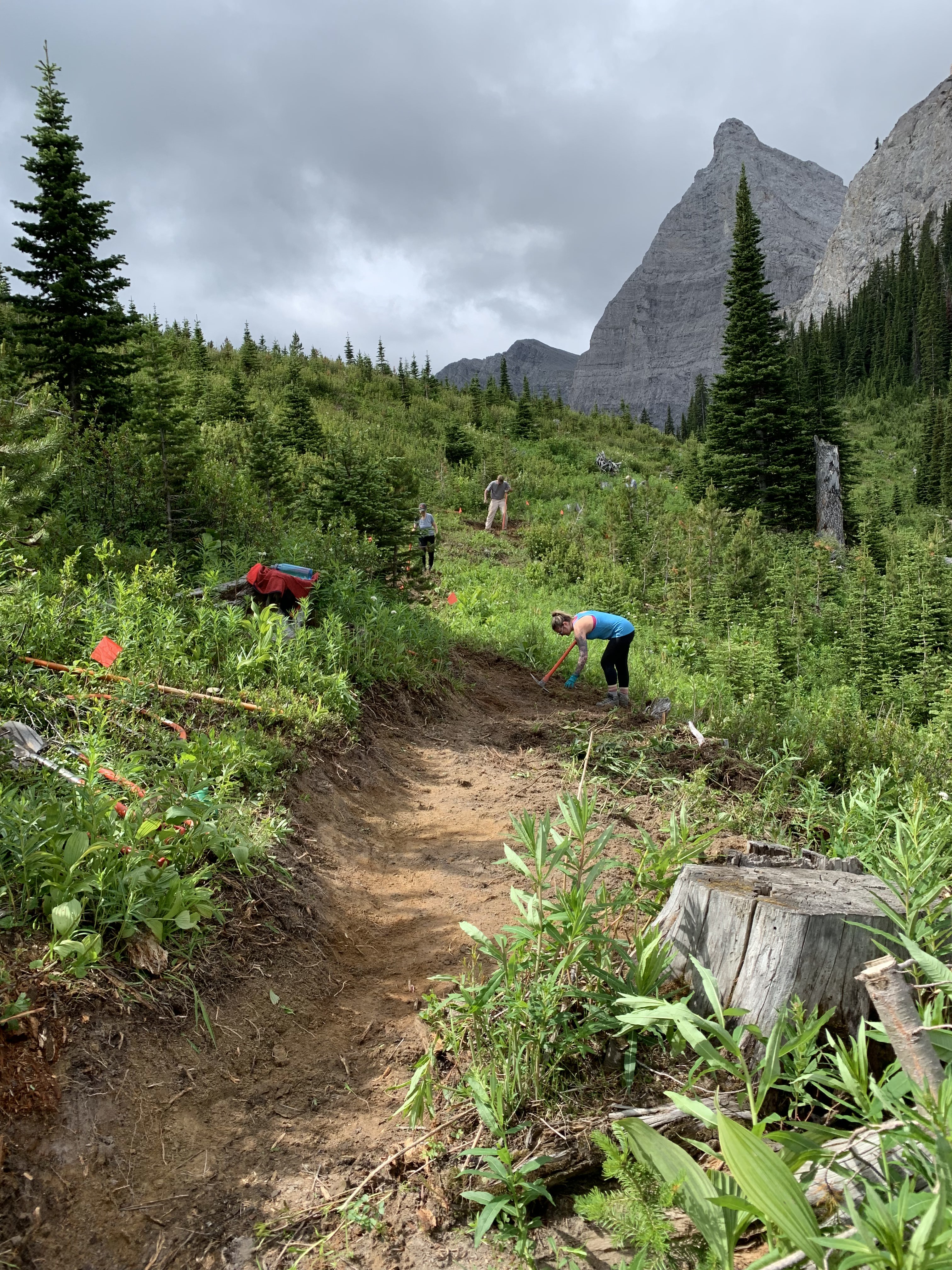
Other than one day of rain, the weather finally improved allowing the crew to work under blue skies for most of the trip. Again, a renewed attention to safety was paramount and extra time was taken to review safety procedures and practices at the start of each work day. The goal of the Signature Trip was to start building trail in Section U, south of Window Mountain Lake. The section featured some fun but still challenging terrain to build trail – wet valley bottom down low and rocky steep slopes up high. In total 1.2 km of new tread was built on Section U.
Building switchbacks up the hillside
The lower section of trail was very wet and necessitated some creative trail building to divert water from the trail and mitigate some very muddy conditions. On the last day of the trip, some volunteers hiked up to the ridge above Section U with spectacular views of Crowsnest Peak and Pass, while a few others hiked to Window Mountain Lake for a quick swim before returning to camp with a deep sense of satisfaction of time well spent on the Great Divide.
Window Mountain Lake
Special thanks to the North Face for outfitting all of our Signature Trip volunteers with cozy fleece sweaters!
GDTA Signature Trip Crew in their North Face gear
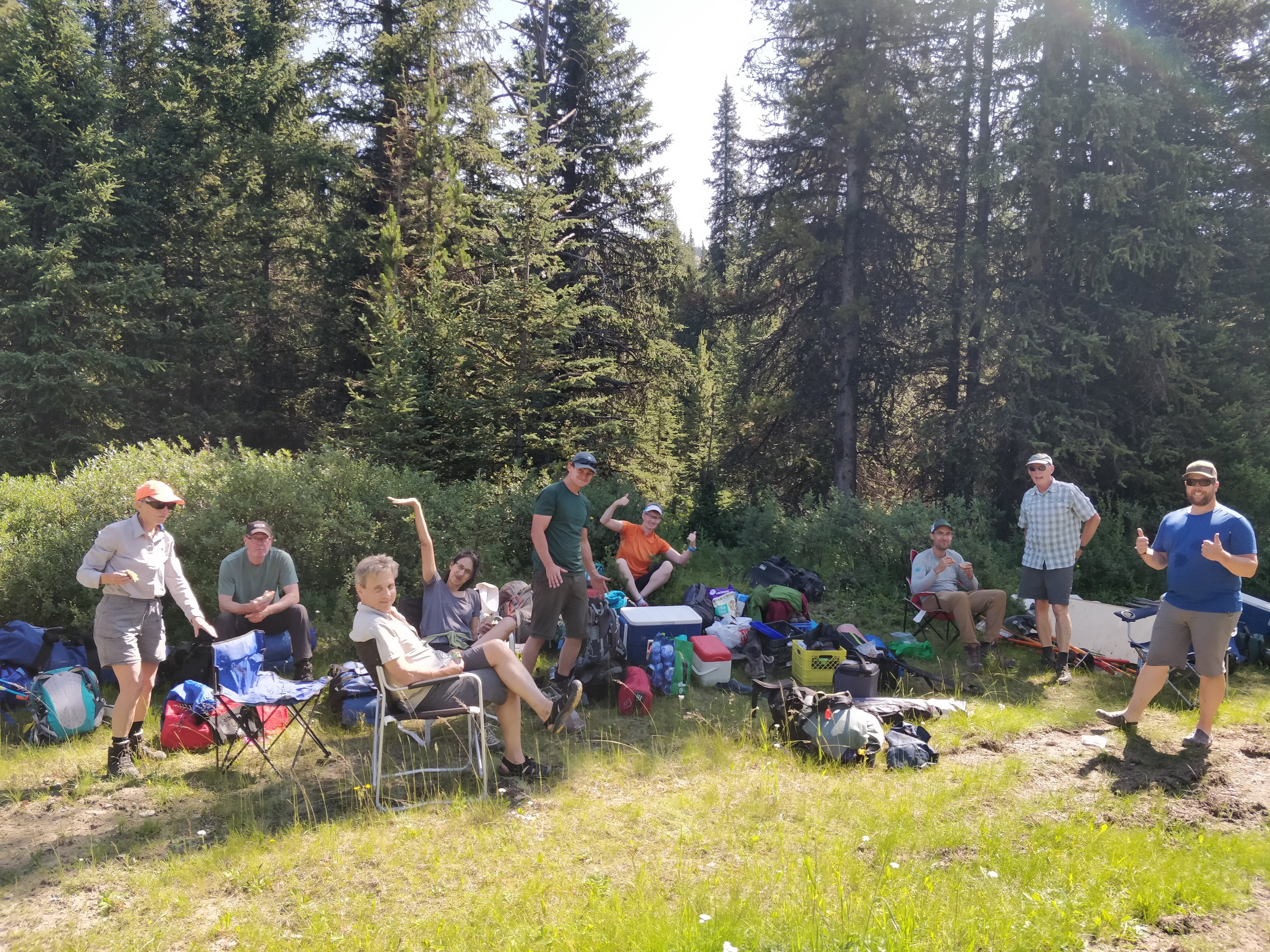
Trip #9 – “Original GDT” Lost Creek, August 2 to 6
The purpose of this trip was to relocate a section of the “Original GDT” near Lost Creek that had been destroyed in the floods of 2013. A crew of 10 volunteers set out to re-locate the trail to a good dry route through the forest.
GDTA Volunteers (in the sunshine)
The crew scouted the area thoroughly in order to flag the optimal route avoiding the wet, brushy meadows. The crew also performed maintenance on the trail toward Cataract Plateau, including much needed chainsaw work. Afterwards everyone enjoyed the spectacular views from the plateau.
Cataract Plateau
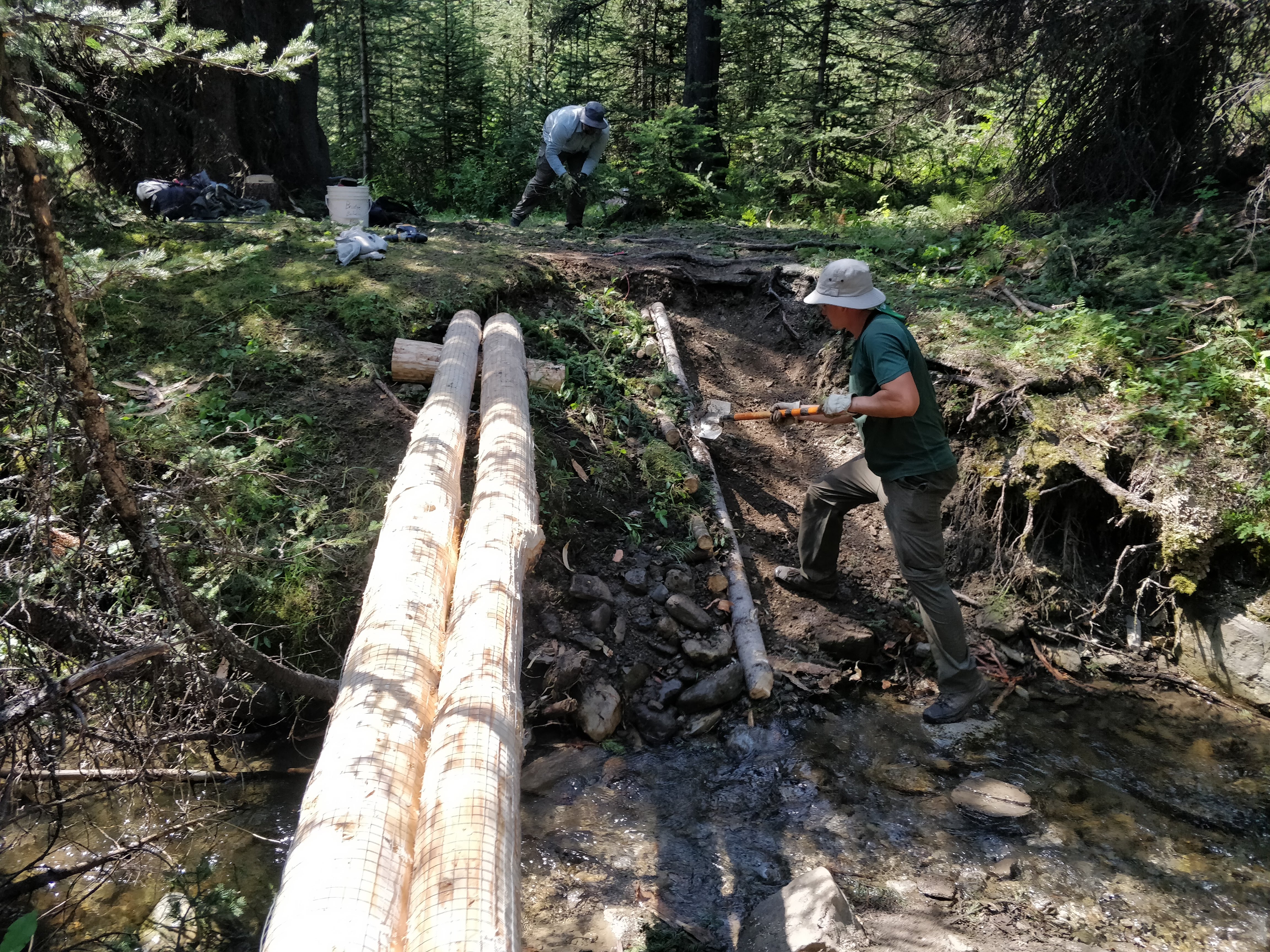
The next three days were spent building two bridges, clearing deadfall, and brushing the old trail. Hot sunny weather (unusual for this summer!) was a challenge but volunteers decided it was much better than cold and rain. A few hundred metres of new tread was completed through the meadow. The last day was spent scouting trail up from the bridge site and assessing trees for a future bridge, preparing for completion of the necessary work to re-route the trail in 2020. It was a great few days of work including a bonus of two thru-hikers arriving in camp one evening – always a highlight.
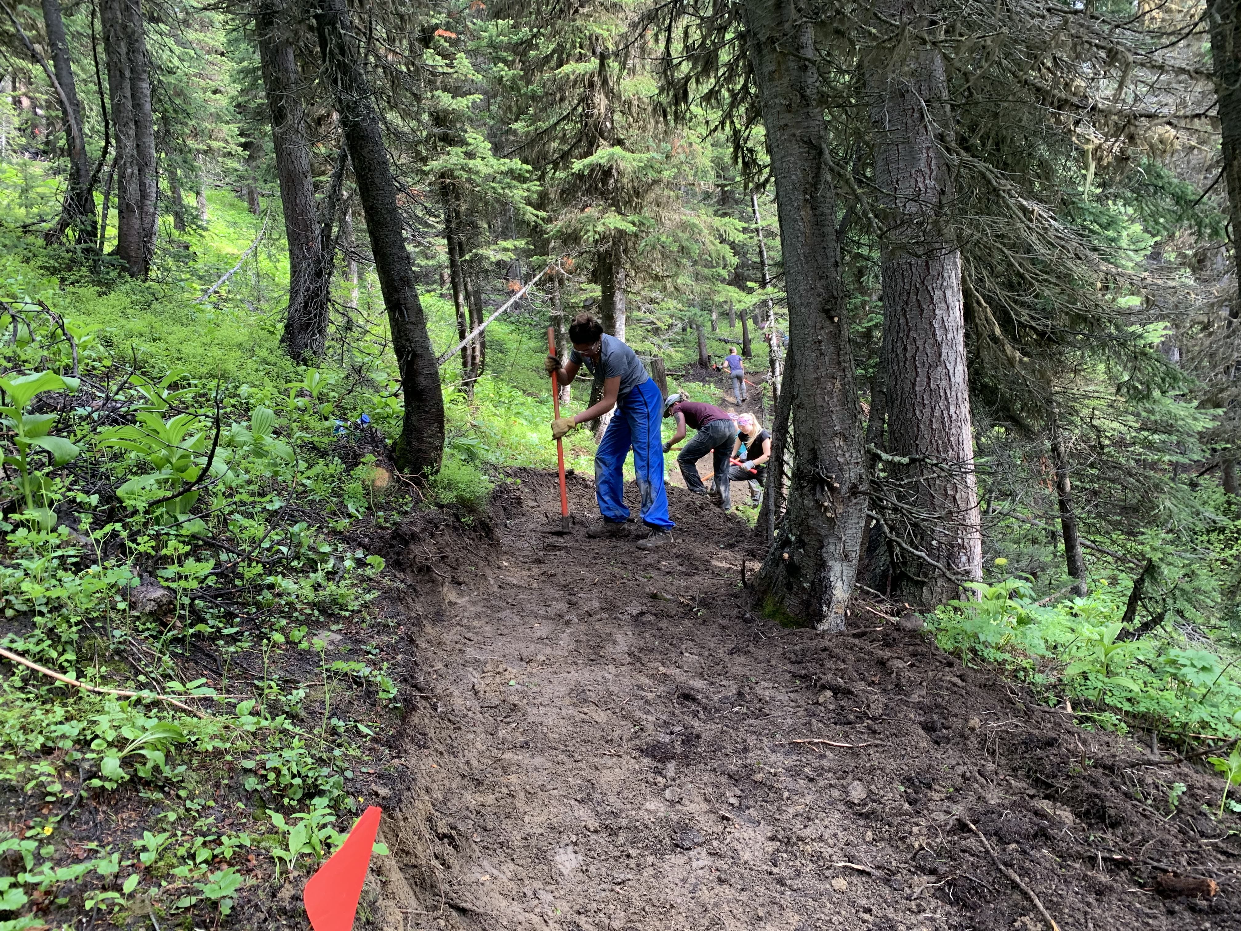
Bridge building
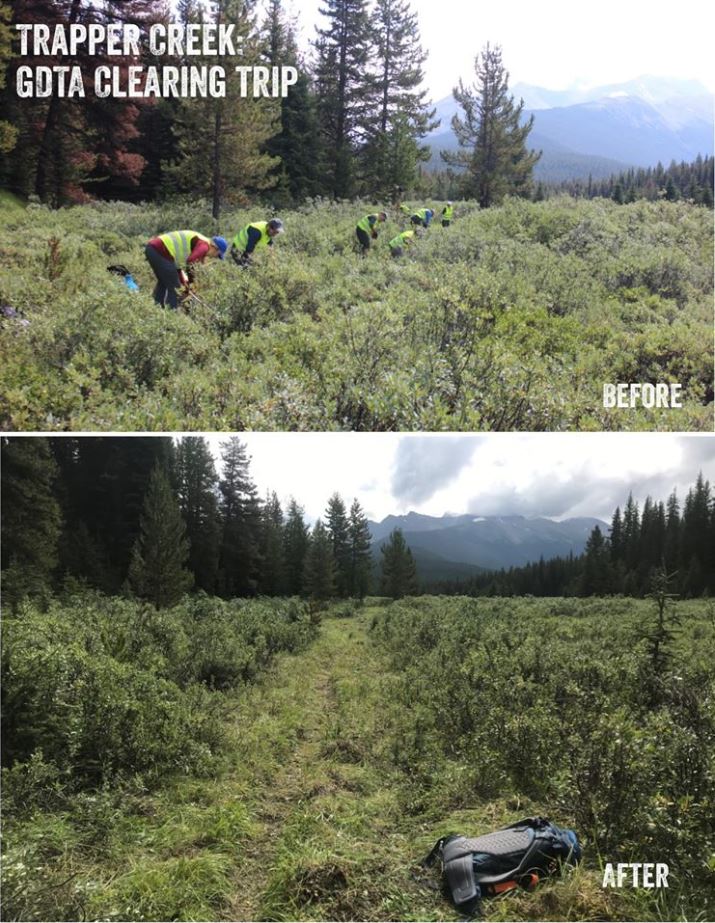
Trip #10 – Maligne Pass Trail, August 10 & 11
Our second annual work trip on Maligne Pass/Trapper Creek Trail in partnership with the Jasper Trails Alliance was a huge success. A cumulative 126 hours from 21 volunteers created a corridor through a field of impenetrable willows, sightlines cleared a densely vegetated area between the willow field and Trapper Creek Campground and all small deadfall on the incoming trail was removed.
Trip #11 concurrent with Trip #12 – David Thompson Heritage Trail, August 29 to September 2
The 2019 work was essentially a continuation of work that began in 2018 with clearing and rehabilitation of the first 8 km of the David Thompson Heritage Trail from its trailhead at Cairnes Creek (end of the Blaeberry FSR) to Lambe Creek. In 2019 our objectives were:
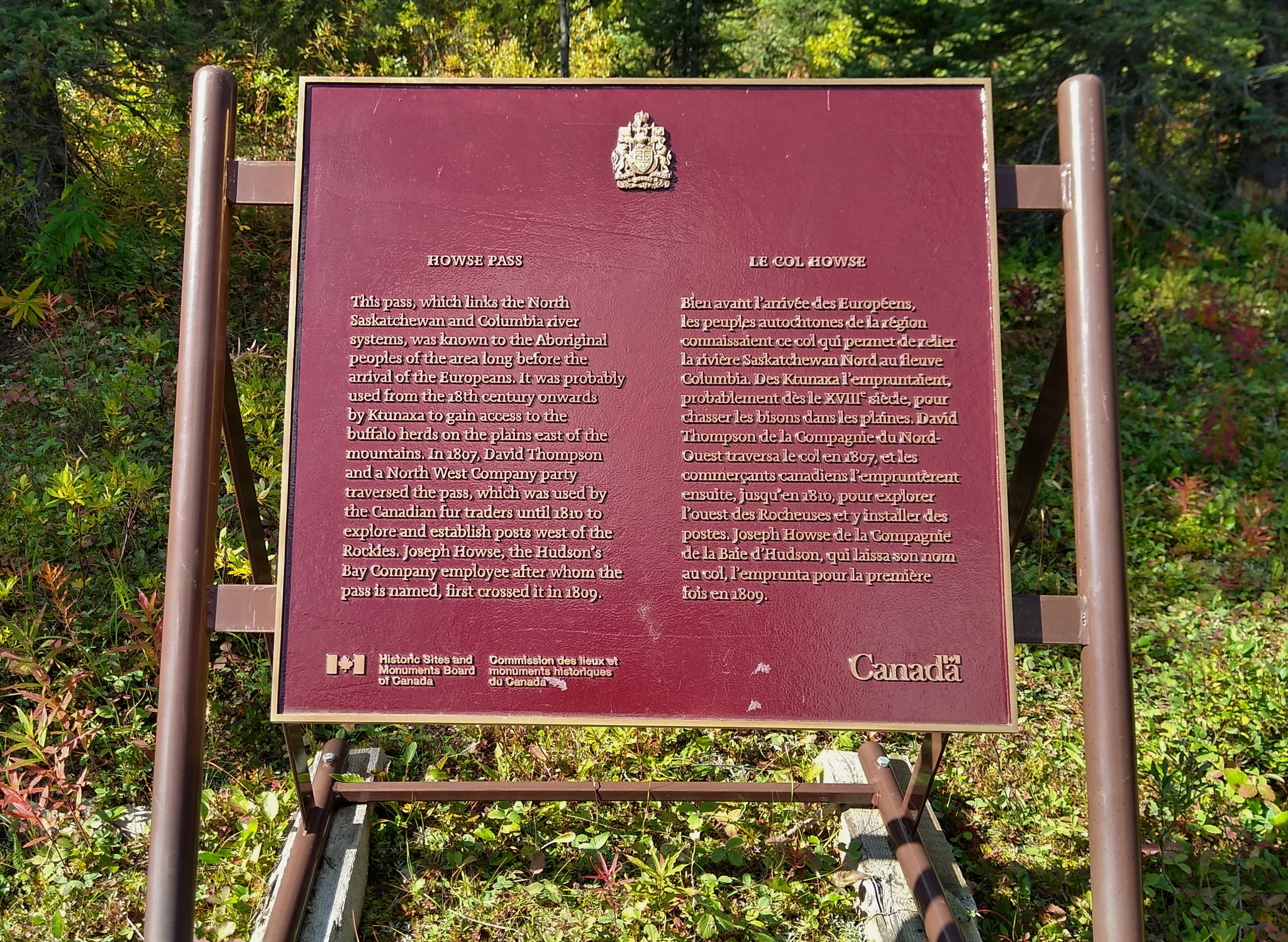
1) Finish this work to the Banff National Park boundary at Howse Pass, a further distance of 5km.
Howse Pass
2) Stabilize and improve (by installation of a handrail, stiffeners and wire mesh) the 2-log bridge over Lambe Creek that had been built in late 2018.
Lambe Creek bridge
3) Make other improvements and enhancements to the first 8 km section, rebuilding, restoring, and reinforcing the trail tread.
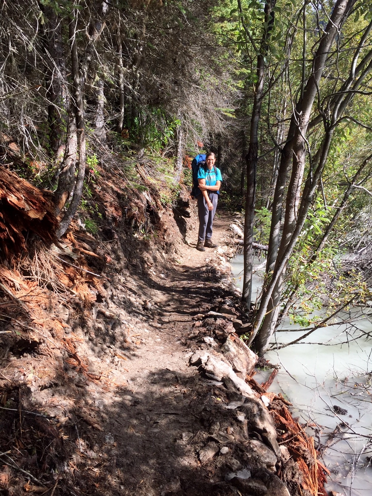
Restored trail next to the Blaeberry River
All of the above objectives were met successfully. The entire 13-km length of the David Thompson Heritage Trail is now completely restored and suitable for foot travel.
Thank you! – Special thanks go out to all of our hard-working volunteers who built, maintained or mapped the trail this year, and everyone who spent countless hours over the winter months getting official authorizations, planning and making sure these trips went smoothly. Well done!
And thanks to our sponsors and partners whose generous donations and support were a huge part of our successful trail work in 2019: MEC, Teck, The North Face, Alberta Equestrian Federation, Columbia Basin Trust, Stihl, Alberta Environment and Parks, Recreation Sites and Trails BC, and the Jasper Trails Alliance.
Winter conditions are here. Snow has fallen on all of the GDT and is accumulating so expect wet, icy and slippery trail conditions. Boots, hiking poles, snow cleats or snowshoes are recommended. Temperatures are below freezing, so be prepared for winter conditions and short days when travelling into the backcountry this winter.
Remember that the GDT is not designed for snow travel and is not maintained in the winter. When the trail is covered in snow, finding it may be impossible so excellent navigation skills are required. Hiking on the GDT when it’s snow covered means exposing yourself to potential avalanche risk. In many places, it’s unwise to travel the trail during these conditions. While planning your hike, research snow conditions and check out the Canadian Avalanche Centre for the latest avalanche bulletins.
TRAIL CLOSURES:
Most trails in Waterton Lakes National Park have now re-opened following the 2017 Kenow wildfire however the Akamina Parkway is now closed to all traffic including pedestrians meaning that hikers cannot access Rowe Lakes trailhead (a9) from Cameron Lake (a8). The GDTA is working with Waterton Lakes National Park staff to come up with a hiking detour prior to next summer. Stay tuned.
Numa Creek Trail (Rockwall access trail) remains closed due to wash out of the bridge over the Vermilion River. The pedestrian bridge is being replaced and access to the Rockwall from this location will be restored next year.
Jasper National Park seasonal closures – The GDT is closed from Four Point Campground (e15) to Signal Mountain Trailhead (e32) and from Moose Pass (f15) to Bess Pass (g3) from November 1, 2019 to February 28, 2020, to prevent trails from facilitating an unnatural level of predator access to threatened woodland caribou.
TRAIL NOTICES:
In 2017, approximately 35 km of the GDT was burned by the Kenow Wildfire between Bertha Bay campground and Font Creek (a19). Some trails that have been damaged by wildfire may require environmental analysis or heavier engineering, and closures could be in place for many months as trails and roads are repaired. The GDTA will continue to monitor and assess the condition of these damaged trails and provide updates as they become available.
From Scarpe Pass (a24), the trail disappears so hikers must route-find up to La Coulotte Ridge, where the hiking becomes significantly more difficult until you reach the ATV track (a27) heading down to the West Castle Road.
The GDT is blocked by avalanche debris south of Tornado Pass (b16). Hikers can get around by traversing up slope.
Leroy Creek has washed out approximately 100m of the trail obscuring the location of the creek ford at 50.677892, -115.317131. Look for cairns on either side of the creek marking the crossing.
The first half of the Amiskwi Trail was cleared in August 2018, but the rest of the trail is in poor shape much of the way to Amiskwi Pass. Expect brushy, overgrown conditions, and several fords of the Amiskwi River.
The David Thompson Heritage Trail was cleared to Howse Pass in September 2019. A new log bridge is in place across Lambe Creek (d10). Cairnes Creek (d9) is a potentially dangerous ford, however currently there are two large trees down across the creek allowing hikers to cross. If these trees wash away, it is recommended to ford the creek early in the morning when glacial melt is lowest.
Descending the north side of Howse Pass (d11), the main route of the GDT now follows Conway Creek and Howse River floodplains wherever possible, without crossing the main channel of the Howse River. The floodplain is wide and scenic. There are several shallow fords of smaller channels on the floodplain so hikers must be prepared to have wet feet while enjoying a significantly better hiking experience than the old overgrown trail strewn with hundreds of fallen trees. In June and early July, the Howse River may be in flood making some sections of the floodplain difficult or impassable in which case hikers should consider using the old trail (now marked as an alternate route). Conversely, in late August and September when the river is low, hikers may be able to ford the main river channel and completely avoid any bushwhacking along the river’s edge. See here for a more detailed route description.
The first 6 km of the Owen Creek Trail are in fair condition. Beyond that point, the trail is in poor shape with several washed out sections. Expect challenging hiking for 3 km including skirting along steep creek-side cliffs and rock-hopping in the creek itself. At km 6, do not take the trail heading up away from the creek (it is a deadend). Look for orange blazes marking the correct route staying near the creek.
The Maligne Pass trail from Pobokton Creek (e20) to just south of Trapper Creek (e24) is no longer being maintained by Parks Canada so expect deteriorating and overgrown trail conditions; long pants are recommended. The Maligne River bridge has been removed. The river can usually be forded in normal summer conditions but can be a deep and challenging ford after periods of heavy rain. Most other bridges are still in place. The Six Passes Route is a cross-country alternative to the overgrown trail for hikers with route-finding experience – Read more here.
The Yates Torrent Bridge is out at the crossing of the Coleman Glacier outflow (near f16). Do not attempt to cross at the old bridge location. There are two options: (1) ford the Smoky River in the floodplain; or (2) ford Yates Torrent approximately 500m upstream (location was flagged in 2017). At both locations attempt to cross early in the morning when glacial melt is the lowest or be prepared for a fast and potentially dangerous creek ford.
The bridges across Gendarme and Carcajou Creeks are out on the Jasper North Boundary Trail. These two creeks are smaller than the Smoky River, but can still be treacherous. Cross Gendarme at the horse crossing just below the old bridge (marked), and Carcajou about 100m below the trail.
Hikers have reported that Wolverine campground and the surrounding trail are flooded. Detour around by following higher ground through the forest west of the trail and campground.
The bridge across Buchanan Creek on the trail to Kakwa Lake, has been removed. The crossing here can be hazardous early in the year or after heavy rains.
ACCESS ROADS:
Winter conditions exist on many mountain highways and roads. Roads can be snowy and icy so check for the latest conditions before you travel and carry chains and/or winter tires. For more information, check out Alberta 511 and Drive BC.
Akamina Parkway and Red Rock Parkway in Waterton Lakes National Park are closed due to ongoing construction but Red Rock Parkway is open to pedestrians.
Highway 40 is seasonally closed from Peter Lougheed Provincial Park to Highwood House beginning December 1.
Forestry Trunk Road 940 is seasonally closed south of Cataract Creek and northwest of Plateau Mountain Road beginning December 1.
Fall colours are here, and so is the snow! Snow has fallen on much of the GDT and is starting to accumulate at higher elevations. Expect wet, slippery and muddy trail conditions. Heavy boots or cleats and poles are recommended. Nighttime and early morning temperatures are below freezing, so be prepared for cold temperatures and shorter days when travelling into the backcountry this fall.
ELK RUTTING SEASON WARNING: It is elk rutting season until mid-October. Warning signs that read “ATTENTION – Elk Mating” have been posted at areas where elk herds often gather. Be aware that bull elk become extremely aggressive during rutting season so keep at least 30 metres away from all elk and never get between a male and female elk.
BEARS: It’s pre-hibernation feeding season for both black and grizzly bears which increases the chances of running into a bear on the trail. It is easy to surprise a bear that is focussed on feeding so make noise while hiking in bear territory. Be alert, make noise, carry bear spray and if you see a bear, back away slowly and leave the area.
TRAIL CLOSURES:
Most trails in Waterton Lakes National Park have now re-opened following the 2017 Kenow wildfire however the Akamina Parkway is now closed to all traffic including pedestrians meaning that hikers cannot access Rowe Lakes trailhead (a9) from Cameron Lake (a8). The GDTA is working with Waterton Lakes National Park staff to come up with a hiking detour prior to next summer. Stay tuned.
Numa Creek Trail (Rockwall access trail) remains closed due to wash out of the bridge over the Vermilion River. The pedestrian bridge is being replaced and access to the Rockwall from this location will be restored next year.
TRAIL NOTICES:
In 2017, approximately 35 km of the GDT was burned by the Kenow Wildfire between Bertha Bay campground and Font Creek (a19). Some trails that have been damaged by wildfire may require environmental analysis or heavier engineering, and closures could be in place for many months as trails and roads are repaired. The GDTA will continue to monitor and assess the condition of these damaged trails and provide updates as they become available.
From Scarpe Pass (a24), the trail disappears so hikers must route-find up to La Coulotte Ridge, where the hiking becomes significantly more difficult until you reach the ATV track (a27) heading down to the West Castle Road.
The GDT is blocked by avalanche debris south of Tornado Pass (b16). Hikers can get around by traversing up slope.
Leroy Creek has washed out approximately 100m of the trail obscuring the location of the creek ford at 50.677892, -115.317131. Look for cairns on either side of the creek marking the crossing.
The first half of the Amiskwi Trail was cleared in August 2018, but the rest of the trail is in poor shape much of the way to Amiskwi Pass. Expect brushy, overgrown conditions, and several fords of the Amiskwi River.
The David Thompson Heritage Trail was cleared to Howse Pass in September 2019. A new log bridge is in place across Lambe Creek (d10). Cairnes Creek (d9) is a potentially dangerous ford, however currently there are two large trees down across the creek allowing hikers to cross. If these trees wash away, it is recommended to ford the creek early in the morning when glacial melt is lowest.
Descending the north side of Howse Pass (d11), the main route of the GDT now follows Conway Creek and Howse River floodplains wherever possible, without crossing the main channel of the Howse River. The floodplain is wide and scenic. There are several shallow fords of smaller channels on the floodplain so hikers must be prepared to have wet feet while enjoying a significantly better hiking experience than the old overgrown trail strewn with hundreds of fallen trees. In June and early July, the Howse River may be in flood making some sections of the floodplain difficult or impassable in which case hikers should consider using the old trail (now marked as an alternate route). Conversely, in late August and September when the river is low, hikers may be able to ford the main river channel and completely avoid any bushwhacking along the river’s edge. See here for a more detailed route description.
The first 6 km of the Owen Creek Trail are in fair condition. Beyond that point, the trail is in poor shape with several washed out sections. Expect challenging hiking for 3 km including skirting along steep creek-side cliffs and rock-hopping in the creek itself. At km 6, do not take the trail heading up away from the creek (it is a deadend). Look for orange blazes marking the correct route staying near the creek.
The Maligne Pass trail from Pobokton Creek (e20) to just south of Trapper Creek (e24) is no longer being maintained by Parks Canada so expect deteriorating and overgrown trail conditions; long pants are recommended. The Maligne River bridge has been removed. The river can usually be forded in normal summer conditions but can be a deep and challenging ford after periods of heavy rain. Most other bridges are still in place. The Six Passes Route is a cross-country alternative to the overgrown trail for hikers with route-finding experience – Read more here.
The Yates Torrent Bridge is out at the crossing of the Coleman Glacier outflow (near f16). Do not attempt to cross at the old bridge location. There are two options: (1) ford the Smoky River in the floodplain; or (2) ford Yates Torrent approximately 500m upstream (location was flagged in 2017). At both locations attempt to cross early in the morning when glacial melt is the lowest or be prepared for a fast and potentially dangerous creek ford.
The bridges across Gendarme and Carcajou Creeks are out on the Jasper North Boundary Trail. These two creeks are smaller than the Smoky River, but can still be treacherous. Cross Gendarme at the horse crossing just below the old bridge (marked), and Carcajou about 100m below the trail.
Hikers have reported that Wolverine campground and the surrounding trail are flooded. Detour around by following higher ground through the forest west of the trail and campground.
The bridge across Buchanan Creek on the trail to Kakwa Lake, has been removed. The crossing here can be hazardous early in the year or after heavy rains.
ACCESS ROADS:
Akamina Parkway and Red Rock Parkway in Waterton Lakes National Park are closed due to ongoing construction but Red Rock Parkway is open to pedestrians.
Fall weather has arrived in the Rockies and that means autumn colours! Trail conditions are generally good but expect some wet and muddy sections during periods of rain. Be prepared for colder temperatures and shorter days when travelling on the trail this month.
ELK RUTTING SEASON WARNING: It is elk rutting season until mid-October. Warning signs that read “ATTENTION – Elk Mating” have been posted at areas where elk herds often gather. Be aware that bull elk become extremely aggressive during rutting season so keep at least 30 metres away from all elk and never get between a male and female elk.
BEARS: It’s pre-hibernation feeding season for both black and grizzly bears which increases the chances of running into a bear on the trail. It is easy to surprise a bear that is focussed on feeding so make noise while hiking in bear territory. Be alert, make noise, carry bear spray and if you see a bear, back away slowly and leave the area.
TRAIL CLOSURES:
WATERTON: The Tamarack Trail reopened on July 31. Most trails in Waterton Lakes National Park have now re-opened following the 2017 Kenow wildfire with the exception of the Alderson Lake Trail and campground which remain closed. The Mount Rowe-Sage Pass Alternate Route in Akamina-Kishinena Provincial Park is also closed. DETOUR: From Waterton Townsite, GDT hikers can follow the Akamina Parkway for 11 km to re-join the GDT at the Rowe Lakes trailhead (a9).
Numa Creek Trail (Rockwall access trail) remains closed due to wash out of the bridge over the Vermilion River. The pedestrian bridge is being replaced and access to the Rockwall from this location will be restored next year.
Trail 7 near Jasper is closed to hikers south of the junction with Trail 7e and north of the junction with Trail 7a due to grizzly and black bears frequenting the area. Detour by taking Trail 7e to Mildred Lake from where you can take several different trails to reach Old Fort Point trailhead. Equestrians can still use Trail 7 but are not to dismount.
Parks Canada has resumed work to replace the Meadow Creek Bridge, approximately 12 kilometres west of the Jasper townsite on Highway 16. Elysium Pass, Virl, Dorothy and Christine Lakes trailhead will be closed until construction is complete, expected in November 2019.
TRAIL NOTICES:
In 2017, approximately 35 km of the GDT was burned by the Kenow Wildfire between Bertha Bay campground and Font Creek (a19). Some trails that have been damaged by wildfire may require environmental analysis or heavier engineering, and closures could be in place for many months, for the health of the trail and the surrounding landscapes as well as the safety of hikers, park staff and volunteers. The GDTA will continue to monitor and assess the condition of these damaged trails and provide updates as they become available.
The 5 km of trail north of Sage Pass that was burned by the 2017 Kenow wildfire has not been cleared since the fire and is considered potentially hazardous due to dead-standing burnt trees.
From Scarpe Pass (a24), the trail disappears so hikers must route-find up to La Coulotte Ridge, where the hiking becomes significantly more difficult until you reach the ATV track (a27) heading down to the West Castle Road.
The GDT is blocked by avalanche debris south of Tornado Pass (b16). Hikers can get around by traversing up slope.
Leroy Creek has washed out approximately 100m of the trail obscuring the location of the creek ford at 50.677892, -115.317131. Look for cairns on either side of the creek marking the crossing.
The first half of the Amiskwi Trail was cleared in August 2018, but the rest of the trail is in poor shape much of the way to Amiskwi Pass. Expect brushy, overgrown conditions, and several fords of the Amiskwi River.
The David Thompson Heritage Trail was cleared to Howse Pass in September 2019. A new log bridge is in place across Lambe Creek (d10). Cairnes Creek (d9) is a potentially dangerous ford, however currently there are two large trees down across the creek allowing hikers to cross. If these trees wash away, it is recommended to ford the creek early in the morning when glacial melt is lowest.
Descending the north side of Howse Pass (d11), the main route of the GDT now follows Conway Creek and Howse River floodplains wherever possible, without crossing the main channel of the Howse River. The floodplain is wide and scenic. There are several shallow fords of smaller channels on the floodplain so hikers must be prepared to have wet feet while enjoying a significantly better hiking experience than the old overgrown trail strewn with hundreds of fallen trees. In June and early July, the Howse River may be in flood making some sections of the floodplain difficult or impassable in which case hikers should consider using the old trail (now marked as an alternate route). Conversely, in late August and September when the river is low, hikers may be able to ford the main river channel and completely avoid any bushwhacking along the river’s edge. See here for a more detailed route description.
The Owen Creek Trail was cleared in July 2015 up to km 6 but there has been some new deadfall since then. Beyond that point, the trail is in poor shape with several washed out sections. Expect challenging hiking for 3 km including skirting along steep creek-side cliffs and rock-hopping in the creek itself. At km 6, do not take the trail heading up away from the creek (it is a deadend). Look for orange blazes marking the correct route staying near the creek.
The bridge between Poboktan and Waterfalls campground (e19) has been replaced.
The Maligne Pass trail from Pobokton Creek (e20) to Trapper Creek (e24) is no longer being maintained by Parks Canada so expect deteriorating and overgrown trail conditions; long pants are recommended. The Maligne River bridge has been removed but the river can be easily forded in normal summer conditions (less than knee deep in mid-summer). Most other bridges are still in place. The Six Passes Route is a cross-country alternative to the overgrown trail for hikers with route-finding experience – Read more here.
The Yates Torrent Bridge is out at the crossing of the Coleman Glacier outflow (near f16). Do not attempt to cross at the old bridge location. There are two options: (1) ford the Smoky River in the floodplain; or (2) ford Yates Torrent approximately 500m upstream (location was flagged in 2017). At both locations attempt to cross early in the morning when glacial melt is the lowest or be prepared for a fast and potentially dangerous creek ford.
The bridges across Gendarme and Carcajou Creeks are out on the Jasper North Boundary Trail. These two creeks are smaller than the Smoky River, but can still be treacherous. Cross Gendarme at the horse crossing just below the old bridge (marked), and Carcajou about 100m below the trail.
Hikers have reported that Wolverine campground and the surrounding trail are flooded. Detour around by following higher ground through the forest west of the trail and campground.
The bridge across Buchanan Creek on the trail to Kakwa Lake, has been removed. The crossing here can be hazardous early in the year or after heavy rains.
ACCESS ROADS:
Akamina Parkway and Red Rock Parkway in Waterton Lakes National Park are closed to vehicles but open to pedestrians.
Trail conditions are generally good but expect some wet and muddy sections during periods of rain. Warm weather means rapid melt during the day resulting in high water levels and potentially dangerous creek crossings, so attempt to ford larger creeks early in the day when water levels are lowest.
GDTA Trail crews are out maintaining the GDT in August so make your presence known when hiking through a work area and say thanks for all their hard work!
BEARS: It’s berry season! Berry bushes border trails, roads and campgrounds on the GDT, and black and grizzly bears are feeding on berries right now. Be bear aware on the trails this summer: be alert, make noise and carry bear spray.
Bear warning in Waterton Lakes National Park: A black bear is frequenting the Lakeshore Trail from the townsite to Boundary Bay.
FIRES: Fire advisories are in effect in Banff, Jasper and Waterton Lakes National Parks. If you must have a campfire in the backcountry, ensure you follow the rules.
TRAIL CLOSURES:
WATERTON UPDATE: The Tamarack Trail reopened on July 31. Most trails in Waterton Lakes National Park have now re-opened following the 2017 Kenow wildfire with the exception of the Alderson Lake Trail and campground which remain closed. The Mount Rowe-Sage Pass Alternate Route in Akamina-Kishinena Provincial Park is also closed. DETOUR: From Waterton Townsite, GDT hikers can follow the Akamina Parkway for 11 km to re-join the GDT at the Rowe Lakes trailhead (a9).
Numa Creek Trail (Rockwall access trail) remains closed due to wash out of the bridge over the Vermilion River. The pedestrian bridge is being replaced and access to the Rockwall from this location will be restored next year.
Trail 7 near Jasper is closed to hikers south of the junction with Trail 7e and north of the junction with Trail 7a due to grizzly and black bears frequenting the area. Detour by taking Trail 7e to Mildred Lake from where you can take several different trails to reach Old Fort Point trailhead. Equestrians can still use Trail 7 but are not to dismount.
Parks Canada has resumed work to replace the Meadow Creek Bridge, approximately 12 kilometres west of the Jasper townsite on Highway 16. Elysium Pass, Virl, Dorothy and Christine Lakes trailhead will be closed until construction is complete, expected in November 2019.
TRAIL NOTICES:
In 2017, approximately 35 km of the GDT was burned by the Kenow Wildfire between Bertha Bay campground and Font Creek (a19). Some trails that have been damaged by wildfire may require environmental analysis or heavier engineering, and closures could be in place for many months, for the health of the trail and the surrounding landscapes as well as the safety of hikers, park staff and volunteers. The GDTA will continue to monitor and assess the condition of these damaged trails and provide updates as they become available.
The 5 km of trail north of Sage Pass that was burned by the 2017 Kenow wildfire has not been cleared since the fire and is considered potentially hazardous due to dead-standing burnt trees.
From Scarpe Pass (a24), the trail disappears so hikers must route-find up to La Coulotte Ridge, where the hiking becomes significantly more difficult until you reach the ATV track (a27) heading down to the West Castle Road.
The GDT is blocked by avalanche debris south of Tornado Pass (b16). Hikers can get around by traversing up slope.
Leroy Creek has washed out approximately 100m of the trail obscuring the location of the creek ford at 50.677892, -115.317131. Look for cairns on either side of the creek marking the crossing.
The first half of the Amiskwi Trail was cleared in August 2018, but the rest of the trail is in poor shape much of the way to Amiskwi Pass. Expect brushy, overgrown conditions, and several fords of the Amiskwi River.
Cairnes Creek (d9): The bridge is washed out making this a potentially dangerous ford. There are two large trees down across the creek allowing hikers to cross. If these trees wash away, it is recommended to ford the creek early in the morning when glacial melt is lowest.
The David Thompson Heritage Trail was cleared from Cairnes Creek to Lambe Creek (d10) in September 2018. A new log bridge is in place across Lambe Creek.
Descending the north side of Howse Pass (d11), the main route of the GDT now follows Conway Creek and Howse River floodplains wherever possible, without crossing the main channel of the Howse River. The floodplain is wide and scenic. There are several shallow fords of smaller channels on the floodplain so hikers must be prepared to have wet feet while enjoying a significantly better hiking experience than the old overgrown trail strewn with hundreds of fallen trees. In June and early July, the Howse River may be in flood making some sections of the floodplain difficult or impassable in which case hikers should consider using the old trail (now marked as an alternate route). Conversely, in late August and September when the river is low, hikers may be able to ford the main river channel and completely avoid any bushwhacking along the river’s edge. See here for a more detailed route description.
The Owen Creek Trail was cleared in July 2015 up to km 6 but there has been some new deadfall since then. Beyond that point, the trail is in poor shape with several washed out sections. Expect challenging hiking for 3 km including skirting along steep creek-side cliffs and rock-hopping in the creek itself. At km 6, do not take the trail heading up away from the creek (it is a deadend). Look for orange blazes marking the correct route staying near the creek.
The bridge between Poboktan and Waterfalls campground (e19) has been replaced.
The Maligne Pass trail from Pobokton Creek (e20) to Trapper Creek (e24) is no longer being maintained by Parks Canada so expect deteriorating and overgrown trail conditions; long pants are recommended. The Maligne River bridge has been removed but the river can be easily forded in normal summer conditions (less than knee deep in mid-summer). Most other bridges are still in place. The Six Passes Route is a cross-country alternative to the overgrown trail for hikers with route-finding experience – Read more here.
The Yates Torrent Bridge is out at the crossing of the Coleman Glacier outflow (near f16). Do not attempt to cross at the old bridge location. There are two options: (1) ford the Smoky River in the floodplain; or (2) ford Yates Torrent approximately 500m upstream (location was flagged in 2017). At both locations attempt to cross early in the morning when glacial melt is the lowest or be prepared for a fast and potentially dangerous creek ford.
The bridges across Gendarme and Carcajou Creeks are out on the Jasper North Boundary Trail. These two creeks are smaller than the Smoky River, but can still be treacherous. Cross Gendarme at the horse crossing just below the old bridge (marked), and Carcajou about 100m below the trail.
Hikers have reported that Wolverine campground and the surrounding trail are flooded. Detour around by following higher ground through the forest west of the trail and campground.
The bridge across Buchanan Creek on the trail to Kakwa Lake, has been removed. The crossing here can be hazardous early in the year or after heavy rains.
ACCESS ROADS:
Akamina Parkway and Red Rock Parkway in Waterton Lakes National Park are closed to vehicles but open to pedestrians.
Alpine wildflowers are blooming! Trail conditions are improving quickly but expect some wet and muddy sections and snow patches lingering at higher elevations. Warm weather means rapid snow melt during the day resulting in high water levels and potentially dangerous creek crossings, so attempt to ford larger creeks early in the day when water levels are lowest.
GDTA Trail crews are out maintaining the GDT in July so make your presence known when hiking through a work area and say thanks for all their hard work!
BEARS: Bears are out and about. Be bear aware on the trails this summer: be alert, make noise and carry bear spray.
FIRES: Fire advisories are in effect in Banff and Jasper National Parks. If you must have a campfire in the backcountry, ensure you follow the rules.
TRAIL CLOSURES:
WATERTON UPDATE: Red Rock Parkway reopened on Friday, July 5. Most trails in Waterton Lakes National Park have re-opened following the 2017 Kenow wildfire but some trails and backcountry campgrounds remain closed. The GDT is closed from the Carthew-Alderson trailhead (a3) to the Summit Lake-Boundary Creek trail junction (a7), and from Lineham Ridge summit (a11) to Lone Lake (a14). The Mount Rowe-Sage Pass Alternate Route in Akamina-Kishinena Provincial Park is also closed. Waterton Lakeshore Trail is open allowing access to the GDT Southern Terminus at the International Boundary (a1). From Waterton Townsite, a detour can be followed to reconnect with the GDT near Sage Pass (a17) via the Red Rock Parkway and Blakiston Valley or Snowshoe Trails.
Partial closure of Three Isle Lake Trail in Peter Lougheed Provincial Park due to rockfall hazard. Detour around the closure using the Upper Lake Trail.
Numa Creek Trail (Rockwall access trail) remains closed due to wash out of the bridge over the Vermilion River. The pedestrian bridge is being replaced and access to the Rockwall from this location will be restored next year.
Trail 7 near Jasper is closed to hikers south of the junction with Trail 7e and north of the junction with Trail 7a due to grizzly and black bears frequenting the area. Detour by taking Trail 7e to Mildred Lake from where you can take several different trails to reach Old Fort Point trailhead. Equestrians can still use Trail 7 but are not to dismount.
Parks Canada has resumed work to replace the Meadow Creek Bridge, approximately 12 kilometres west of the Jasper townsite on Highway 16. Elysium Pass, Virl, Dorothy and Christine Lakes trailhead will be closed until construction is complete, expected in November 2019.
TRAIL NOTICES:
In 2017, approximately 35 km of the GDT was burned by the Kenow Wildfire between Bertha Bay campground and Font Creek (a19). Some trails that have been damaged by wildfire may require environmental analysis or heavier engineering, and closures could be in place for many months, for the health of the trail and the surrounding landscapes as well as the safety of hikers, park staff and volunteers. The GDTA will continue to monitor and assess the condition of these damaged trails and provide updates as they become available.
The 5 km of trail north of Sage Pass that was burned by the 2017 Kenow wildfire has not been cleared since the fire and is considered potentially hazardous due to dead-standing burnt trees.
From Scarpe Pass (a24), the trail disappears so hikers must route-find up to La Coulotte Ridge, where the hiking becomes significantly more difficult until you reach the ATV track (a27) heading down to the West Castle Road.
The GDT is blocked by avalanche debris south of Tornado Pass (b16). Hikers can get around by traversing up slope.
Leroy Creek has washed out approximately 100m of the trail obscuring the location of the creek ford at 50.677892, -115.317131. Look for cairns on either side of the creek marking the crossing.
The first half of the Amiskwi Trail was cleared in August 2018, but the rest of the trail is in poor shape much of the way to Amiskwi Pass. Expect brushy, overgrown conditions, and several fords of the Amiskwi River.
Cairnes Creek (d9): The bridge is washed out making this a potentially dangerous ford. There are two large trees down across the creek allowing hikers to cross. If these trees wash away, it is recommended to ford the creek early in the morning when glacial melt is lowest.
The David Thompson Heritage Trail was cleared from Cairnes Creek to Lambe Creek (d10) in September 2018. A new log bridge is in place across Lambe Creek.
Descending the north side of Howse Pass (d11), the main route of the GDT now follows Conway Creek and Howse River floodplains wherever possible, without crossing the main channel of the Howse River. The floodplain is wide and scenic. There are several shallow fords of smaller channels on the floodplain so hikers must be prepared to have wet feet while enjoying a significantly better hiking experience than the old overgrown trail strewn with hundreds of fallen trees. In June and early July, the Howse River may be in flood making some sections of the floodplain difficult or impassable in which case hikers should consider using the old trail (now marked as an alternate route). Conversely, in late August and September when the river is low, hikers may be able to ford the main river channel and completely avoid any bushwhacking along the river’s edge. See here for a more detailed route description.
The Owen Creek Trail was cleared in July 2015 up to km 6 but there has been some new deadfall since then. Beyond that point, the trail is in poor shape with several washed out sections. Expect challenging hiking for 3 km including skirting along steep creek-side cliffs and rock-hopping in the creek itself. At km 6, do not take the trail heading up away from the creek (it is a deadend). Look for orange blazes marking the correct route staying near the creek.
The bridge between Poboktan and Waterfalls campground (e19) has been replaced.
The Maligne Pass trail from Pobokton Creek (e20) to Trapper Creek (e24) is no longer being maintained by Parks Canada so expect deteriorating and overgrown trail conditions; long pants are recommended. The Maligne River bridge has been removed but the river can be easily forded in normal summer conditions (less than knee deep in mid-summer). Most other bridges are still in place. The Six Passes Route is a cross-country alternative to the overgrown trail for hikers with route-finding experience – Read more here.
The Yates Torrent Bridge is out at the crossing of the Coleman Glacier outflow (near f16). Do not attempt to cross at the old bridge location. There are two options: (1) ford the Smoky River in the floodplain; or (2) ford Yates Torrent approximately 500m upstream (location was flagged in 2017). At both locations attempt to cross early in the morning when glacial melt is the lowest or be prepared for a fast and potentially dangerous creek ford.
The bridges across Gendarme and Carcajou Creeks are out on the Jasper North Boundary Trail. These two creeks are smaller than the Smoky River, but can still be treacherous. Cross Gendarme at the horse crossing just below the old bridge (marked), and Carcajou about 100m below the trail.
Hikers have reported that Wolverine campground and the surrounding trail are flooded. Detour around by following higher ground through the forest west of the trail and campground.
The bridge across Buchanan Creek on the trail to Kakwa Lake, has been removed. The crossing here can be hazardous early in the year or after heavy rains.
ACCESS ROADS:
Akamina Parkway and Red Rock Parkway in Waterton Lakes National Park are closed to vehicles but open to pedestrians.
It’s transition time on the GDT. Valley bottom trails at lower elevations vary from bare and dry to wet and muddy, while most trails at higher elevation are still snow covered. With warmer weather, trail conditions can change quickly so plan for varying conditions – boots, cleats and/or poles are recommended.
CREEKS: Rapid snow melt during this time of year results in high water levels and potentially dangerous creek crossings, particularly later in the day. Attempt to ford larger creeks early in the day when water levels are lowest.
ELK CALVING SEASON: May 15 to June 30. Protective mother elk will aggressively protect their newborns by kicking and charging at people. Stay at least 30 metres away from all elk during this time of year. Pay attention to trail closures in known elk calving areas.
TICKS: It’s tick season. Long pants tucked into your socks are recommended. Be extra careful when in areas with a lot of underbrush and check yourself and your clothing after your hike.
BEARS: With spring’s arrival, bears are leaving their dens in search of food. Be bear aware on the trails this spring, make noise and carry bear spray.
FIRES: Fire advisories are in effect in Banff and Jasper National Parks. If you must have a campfire in the backcountry, ensure you follow the rules.
TRAIL CLOSURES:
UPDATED: Due to the 2017 Kenow wildfire some trails and backcountry campgrounds in Waterton Lakes National Park and Akamina Kishinena Provincial Park remain closed. The GDT is closed from the Carthew-Alderson trailhead (a3) to the Summit Lake-Boundary Creek trail junction (a7), and from Lineham Ridge summit (a11) to Lone Lake (a14). Waterton Lakeshore Trail is open allowing access to the GDT Southern Terminus at the International Boundary (a1). From Waterton Townsite, a detour can be followed to reconnect with the GDT near Sage Pass (a17) via Blakiston Valley or Snowshoe Trails.
Numa Creek Trail (Rockwall access trail) remains closed due to wash out of the bridge over the Vermilion River. The pedestrian bridge is being replaced and access to the Rockwall from this location will be restored next year.
Trail 7 near Jasper is closed to hikers south of the junction with Trail 7e and north of the junction with Trail 7a due to grizzly and black bears frequenting the area. Detour by taking Trail 7e to Mildred Lake from where you can take several different trails to reach Old Fort Point trailhead. Equestrians can still use Trail 7 but are not to dismount.
Parks Canada has resumed work to replace the Meadow Creek Bridge, approximately 12 kilometres west of the Jasper townsite on Highway 16. Elysium Pass, Virl, Dorothy and Christine Lakes trailhead will be closed until construction is complete, expected in November 2019.
TRAIL NOTICES:
In 2017, approximately 35 km of the GDT was burned by the Kenow Wildfire between Bertha Bay campground and Font Creek (a19). Some trails that have been damaged by wildfire may require environmental analysis or heavier engineering, and closures could be in place for many months, for the health of the trail and the surrounding landscapes as well as the safety of hikers, park staff and volunteers. The GDTA will continue to monitor and assess the condition of these damaged trails and provide updates as they become available.
From Scarpe Pass (a24), the trail disappears so hikers must route-find up to La Coulotte Ridge, where the hiking becomes significantly more difficult until you reach the ATV track (a27) heading down to the West Castle Road.
The GDT is blocked by avalanche debris south of Tornado Pass (b16). Hikers can get around by traversing down slope.
Leroy Creek has washed out approximately 100m of the trail obscuring the location of the creek ford at 50.677892, -115.317131. Look for cairns on either side of the creek marking the crossing.
The first few kilometres of the Amiskwi Trail were cleared in August 2018, but the rest of the Amiskwi Trail is in poor shape much of the way to Amiskwi Pass. Expect brushy, overgrown conditions, poor or non-existent trail requiring some route-finding, and several fords of the Amiskwi River.
Cairnes Creek (d9): The bridge is washed out making this a potentially dangerous ford. There are two large trees down across the creek allowing hikers to cross. If these trees wash away, it is recommended to ford the creek early in the morning when glacial melt is lowest.
The David Thompson Heritage Trail was cleared from Cairnes Creek to Lambe Creek (d10) in September 2018. A new log bridge is in place across Lambe Creek.
Descending the north side of Howse Pass (d11), the main route of the GDT now follows Conway Creek and Howse River floodplains wherever possible, without crossing the main channel of the Howse River. The floodplain is wide and scenic. There are several shallow fords of smaller channels on the floodplain so hikers must be prepared to have wet feet while enjoying a significantly better hiking experience than the old overgrown trail strewn with hundreds of fallen trees. In June and early July, the Howse River may be in flood making some sections of the floodplain difficult or impassable in which case hikers should consider using the old trail (now marked as an alternate route). Conversely, in late August and September when the river is low, hikers may be able to ford the main river channel and completely avoid any bushwhacking along the river’s edge. See here for a more detailed route description.
The Owen Creek Trail was cleared in July 2015 up to km 6 but there has been some new deadfall since then. Beyond that point, the trail is in poor shape with several washed out sections. Expect challenging hiking for 3 km including skirting along steep creek-side cliffs and rock-hopping in the creek itself. At km 6, do not take the trail heading up away from the creek (it is a deadend). Look for orange blazes marking the correct route staying near the creek.
A bridge is out between Poboktan campground and Waterfalls campground (e19) and the creek is impassable during periods of high water. No detour is available.
The Maligne Pass trail from Pobokton Creek (e20) to Trapper Creek (e24) is no longer being maintained by Parks Canada so expect deteriorating and overgrown trail conditions; long pants are recommended. The Maligne River bridge has been removed but the river can be easily forded in normal summer conditions (less than knee deep in mid-summer). Most other bridges are still in place. The Six Passes Route is a cross-country alternative to the overgrown trail for hikers with route-finding experience – Read more here.
The Yates Torrent Bridge is out at the crossing of the Coleman Glacier outflow (near f16). Do not attempt to cross at the old bridge location. There are two options: (1) ford the Smoky River in the floodplain; or (2) ford Yates Torrent approximately 500m upstream (location was flagged in 2017). At both locations attempt to cross early in the morning when glacial melt is the lowest or be prepared for a fast and potentially dangerous creek ford.
The bridges across Gendarme and Carcajou Creeks are out on the Jasper North Boundary Trail. These two creeks are smaller than the Smoky River, but can still be treacherous. Cross Gendarme at the horse crossing just below the old bridge (marked), and Carcajou about 100m below the trail.
Hikers have reported that Wolverine campground and the surrounding trail are flooded. Detour around by following higher ground through the forest west of the trail and campground.
The bridge across Buchanan Creek on the trail to Kakwa Lake, has been removed. The crossing here can be hazardous early in the year or after heavy rains.
ACCESS ROADS:
Akamina Parkway and Red Rock Parkway in Waterton Lakes National Park are closed to vehicles but open to pedestrians.
Last April 7–13, organizations across the country celebrated National Volunteer Week. The thematic premise for recognizing Canada’s 12.7 million volunteers was simple: collectively, they lift communities.
We are no stranger to this phenomenon. Did you know that the GDTA is an organization run almost entirely by volunteers? It’s the joint work of 100+ individuals who give whatever time they have to help build, maintain, promote, and protect the trail and wilderness corridor we all cherish.
Happy volunteers on Tornado Saddle during our 2018 walking maintenance trip
Our work is driven by a shared belief in the social, economic, environmental, and health benefits of sustainable outdoor recreation. We don’t just build and maintain trail, we partner with other organizations, businesses, and municipal governments to enrich local communities and foster environmental stewardship.
We’d like to thank again all our supporters, partners, and volunteers. There are no words strong enough to express how appreciated and critical your support and commitment have been to the growth of the GDTA.
Let’s build on this momentum together in 2019. Here are some ways in which you can help:
If you are hiking the GDT, consider sharing with us your photographs, videos, writing, and/or other forms of art that put the trail and its experience in the spotlight. We’ll feature them on our website, social media, and/or official documents with proper credits.
Submit trail reports (accompanied by photographs of trail conditions) to us by email.
Become a trail crew leader, camp manager, safety officer, cook, and more on a trip.
Help our equipment manager in Calgary to repair and maintain our tools and trailers.
Join a committee to help organize outreach events and fundraisers, advocate for the trail and its protection, plan for trail building trips, apply for grants, recruit corporate partners, revise safety procedures, update hiking logistics information, and more.
Become a board member.
Share your legal, marketing, or accounting skills.
Help us develop a youth stewardship program.
Help produce and manage content for our website and social media.
Become a corporate business partner and/or encourage your employer to support our work.