Brianna Sharpe’s Globe & Mail article in April 2022 entitled “Hikers push for Alberta’s Great Divide Trail to be given official recognition” brought to mind one of the many opinion pieces expressed during the story telling sessions that formed the backbone of the book Tales from the Great Divide, Vignettes on the Origins and Early History of Canada’s Great Divide Trail and the Great Divide Trail Association. Perhaps given the immense and growing popularity of trails during the pandemic will make federal and provincial politicians more receptive to the notion of legislation to protect national long-distance trails than they have been since the 1970s. In these sections of dialogue taken from the book, DAVE refers to Dave Higgins, JENNY to Jenny Feick (rhymes with hike), and CLIFF to Cliff White. Letters in bold indicate that the person speaking emphasized those words.
For anyone interested in reading more stories from the folks who initiated the idea of Canada’s Great Divide Trail and Great Divide Trail Association, you can still purchase a copy of the Second Edition of the book in three ways:
Order a print-on-demand version from Amazon for Cdn $85.00 (rate in US$ varies with the exchange rate) plus shipping (free for Amazon Prime members).
Arrange to purchase a printed copy directly in person from Jenny Feick, the editor, in the Invermere area for Cdn $65.00 (shipping anywhere in Canada would cost $20.00) by emailing jenny.feick@gmail.com.
From Chapter Four, Pages 110-111 of Tales from the Great Divide, 2nd edition
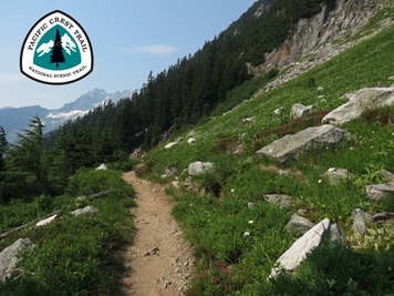
DAVE: “…the problem in Canada is that we have no overarching legislation that relates to hiking trails. In the U.S., good old President Nixon, in 1968, 50 years ago, signed a piece of legislation called the National Scenic Trails Act[1], which allowed for immediate recognition and government support and protection of long-distance trails that were already on the ground there, of which there were several, like the Appalachian Trail, Continental Divide Trail[2], Pacific Crest Trail[3], amongst others.”
“So, the problem here [in Canada] is that these people [civil servants and politicians], with their attitudes and biases, can hold sway. In the U.S., that can’t happen now because the legislation is the main determining factor. Now Donald Trump could potentially…”
JENNY: “Annihilate it.”
DAVE: “But that’s probably well below his radar.”
CLIFF: “The Appalachian Trail. In the west, obviously most of those [long-distance trails] are on federal lands, so it’s a no-brainer, but how does it work for the Appalachian Trail where you must…”
DAVE: “In reality, the Appalachian Trail is probably 99 percent on public land.”
CLIFF: “So, state or federal?”
DAVE: “Both. The National Scenic Trails Act allowed for gradual purchase of private lands over time with the goal of it being 100 percent on public land eventually. Then we have the Bruce Trail in Ontario that’s been on the ground in various forms for over 50 years, and it has none of that. So, it’s probably 80 or 90 percent on private land for its 700 kilometres.”
JENNY: “It’s much harder.”
DAVE: “Its route [the Bruce Trail] is changing every year, because a land changes hands and the new owner says, ‘Screw that! I want them off my property.’ So, now it’s on the road, or it’s looking for some other way around it [the private land parcel where the trail used to be]…”
CLIFF: “It’s like a game of Chinese checkers for this [Great Divide] Trail, because you’ve got Alberta and BC Parks never agreeing on anything all at the same time.”
DAVE: “But it is virtually all on public land. So, you don’t have the danger of the [Great Divide] Trail being punted off of its location at a whim [of a private landowner], right?”
“But in the States, they have that with the Appalachian Trail. A lot of it was on private land, but the National Scenic Trails Act allowed it to be gradually converted. As lands came up for sale, the [federal or state] government purchased these lands. So, they’re miles ahead of us in terms of how they look at this kind of thing.”
Background
Contrary to the headline of the Globe & Mail article, the GDT is not Alberta’s trail. The GDTA is incorporated federally since the GDT is an interprovincial trail following the nationally significant watershed divide that forms the border between Alberta and British Columbia. The GDTA is a federal charitable organization. Ideally, all three governments should be recognizing the GDT and setting aside a protected corridor along the GDT route. Unlike the U.S.A., Canada lacks much-needed legislation to designate and protect national scenic long distance trails.
The Appalachian Trail was one of the first long-distance trails to benefit from the U.S.A’s National Trail Systems Act of 1968.
When the National Trails Systems Act in the U.S.A. was enacted, it also designated the Pacific Crest Trail as a National Scenic Trail.
In the mid-1970s, the American Continental Divide Trail, like Canada’s Great Divide Trail, was proposed but was not an official trail.
By 1978, the Continental Divide Trail became a reality thanks to the National Trails Systems Act in the U.S.A. whereas Canada’s Great Divide Trail still struggles for official recognition despite the past and present efforts of the Great Divide Trail Association.
[1] Editor’s Note: Actually called the National Trails Systems Act, this legislation mandated the establishment, protection and management of National Scenic Trails and other types of trails. The first two National Scenic Trails were the Appalachian Trail (AT) (see Chapter 2, Footnote #9 on page 10, for a description of the AT), and the Pacific Crest Trail (PCT) (see Footnote #133 below).
[2] The Continental Divide Trail was still just an idea in 1974 and was not designated a National Scenic Trail until 1978. Read more about this in Chapter Three (see Footnote #20 on page 21).
[3] The PCT travels 2,653 mi. (4,270 km), beginning at the Mexican border and heading north along the Sierra Nevada and the Cascade Mountains, passing through California, Oregon and Washington states in the U.S.A. into Manning Provincial Park in B.C., Canada.
I recalled the old GDTA Trail Users Code while listening to the Her Odyssey duo when Lani Smith, my husband Ian Hatter and I met them for lunch at Truffle Pigs in Field on a clear sunny September day in 2021. Bethany Hughes and Lauren Reed entertained us with the tales of their adventures going SOBO on the GDT from Kakwa to Field. We agreed to meet them again at Interlakes Campground in Peter Lougheed Provincial Park. From there, they would backpack on to Waterton Lakes National Park. They expressed astonishment about how ill-prepared some thru-hikers seemed and concerned about how much garbage and still-burning campfires were being left behind by some of the hikers on the GDT. They said they were trying to educate people on the no-trace camping concept through some of their blogs on the Her Odyssey website. They suggested that the GDTA set more accurate expectations about the condition of the trail and how to prepare for the challenges and instill backcountry ethics in their clientele. When they gave their talk at the GDTA’s AGM later that month, they made similar points.
So, last fall, I thought I should dig out the old trail user’s code that the first iteration of the GDTA (from the mid-1970s to late 1980s) developed. It was near and dear to my heart. The promotion of the Great Divide Trail User’s Code was something that Dave Higgins and I fostered, having been Bruce Trail Association members in Ontario before we moved to Alberta in 1973/74, and thus familiar with the BTA’s Trail User’s Code.
At first, I thought the Code might be in Tales from the Great Divide. Interestingly enough, no one interviewed for that book specifically mentioned it, although they did talk at length about the GDTA’s policy paper where the code was first published in 1975.
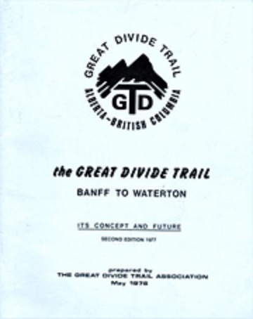
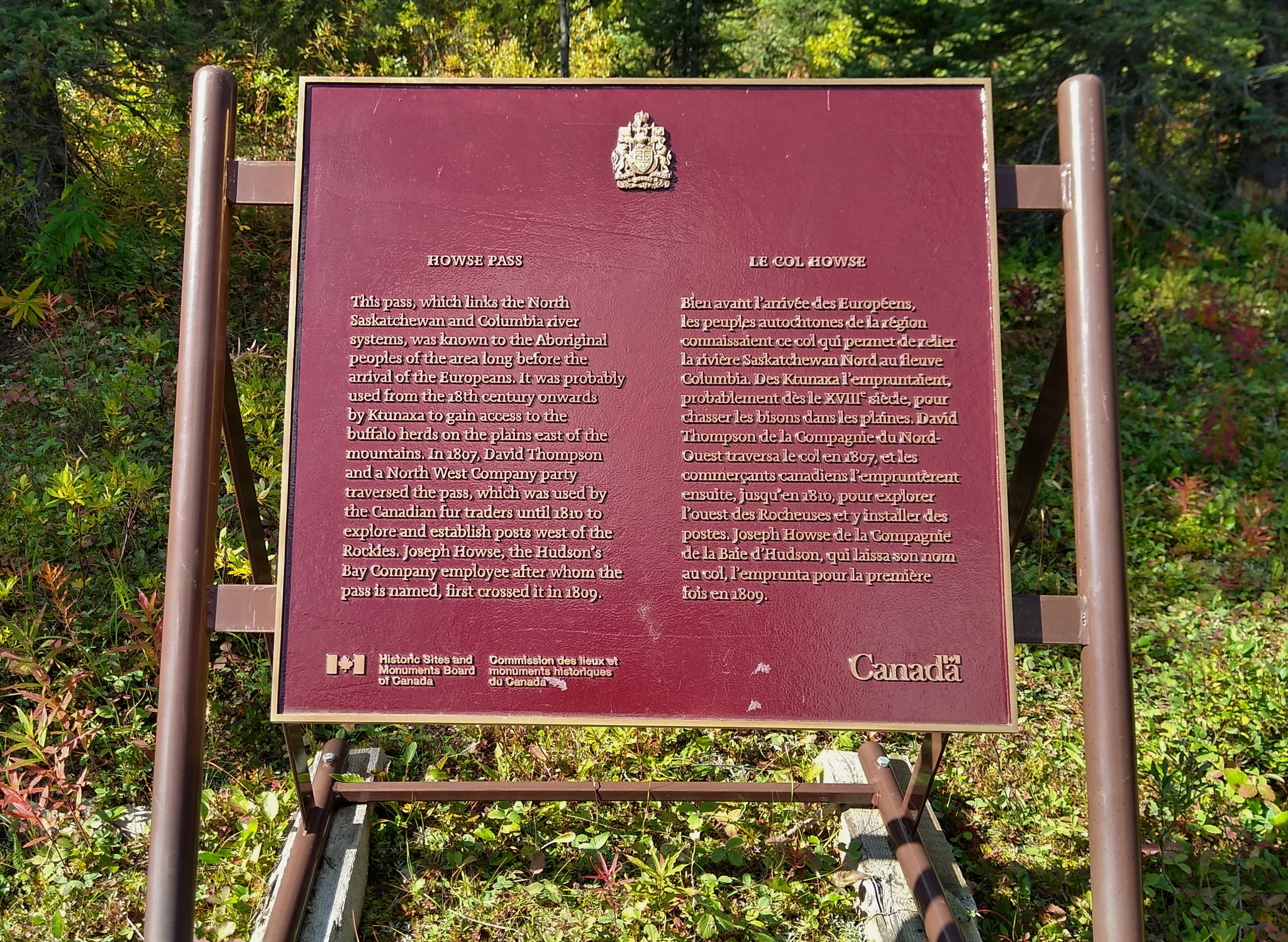
The first GDT’s Trail User’s Code appeared in this document used by the early GDTA members to promote the concept of the GDT.
In that report, entitled the Great Divide Trail: Banff to Waterton, Its Concept and Future, on pages 9-10, it stated that the fifth aim of the GDTA was “to encourage proper wilderness etiquette through the Trail User’s Codes, newsletters and other publications.” It then presented the Great Divide Trail User’s Code.
The Great Divide Trail User’s Code
Travel only along marked routes.
Carry out all garbage (if you can carry it in full, you can carry it out empty!)
Do not disturb wildlife. Even approaching with a camera can constitute harassment.
Do not damage vegetation. Be especially careful with the fragile plants of the alpine and sub-alpine zone, and never cut green trees or boughs.
Do not graze horses in alpine areas. Avoid camping above treeline.
Light cooking fires at official campsites only and in designated sites. Drench fires after use (better still, carry a light-weight hikers’ stove).
Leave campsites tidier than the way you found them.
Clear the trail of obstructions (windfall) when possible and desirable.
Travel in small groups: large parties cause excessive disturbance, and travelling alone can be hazardous.
Travel for pleasure —not to establish records.
Leave only your thanks and take nothing but photographs.
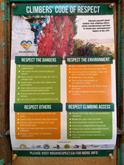
Poster depicting the Climbers Code of Respect on a bulletin board in Canmore, AB in May 2022.
Over the winter, I corresponded with Doug Borthwick, Brad Vaillancourt, Joan Pendleton, and Deb Yanchula. They agreed there would be merit in resurrecting the old GDTA Trail User’s Code, still mostly applicable at 47-years old, and updating it to suit the GDT experience in the 2020s. Over the past 50 years, changes in technology, visitation, park agency regulations, and required permits need to be reflected and some formalizing of “Leave No Trace” principles would be useful to incorporate as well. Trail Angel etiquette may also be worth including.
So, I agreed to coordinate putting a draft revised GDTA’s Trail User’s Code together for consideration by the GDTA. I am thus interested in suggestions from individuals reading this issue of The Pathfinder, especially those who have been on the trail in the past decade, either travelling or working, on the updates you think need to be made to contemporize the old GDTA’s Trail User’s Code. Please send your ideas and any recommended wording to me at jenny.feick@gmail.com with the subject line “Suggestions for a New GDTA Trail User’s Code”. Keep in mind that we are striving for a clear, concise, simple and effective code of conduct. Thank you!
The GDTA is pleased to announce several new corporate supporters that were engaged this year. These are industrious, small businesses whose products and services are all about hikers – gear, lodging, food, resupply, information sources, and memorabilia. Like us, they are outdoors enthusiasts and believe in taking care of and preserving our precious mountains and nature.
These new supporters believe in the GDTA and its mission to maintain and preserve the wild Canadian Rocky Mountains for future generations. To show their support, they very generously provide discounts to GDTA members.
The GDTA extends a big
Thank You
to our new corporate supporters and wishes them all the best in their businesses.
To all our GDTA readership, please enjoy exploring and shopping at these businesses. We think you will find their products and services useful and relevant for your hiking adventures.
New GDTA Corporate Supporters and Member Discounts**
**Please note that proof of GDTA membership is required to access these discounts. All members, please keep a photo of your membership payment confirmation email with your name and the date clearly showing.
GearTrade
GearTrade was founded in 2012 in Okotoks, Alberta by an outdoor enthusiast and entrepreneur who saw a need for an outdoor gear marketplace.
Over the years, this local business has flourished with online sales throughout North America.
“However, it is still the little touches, customer service, and professional advice that matter most to us. We strive to take the time needed to make sure our customers walk away with the right product for their next adventure.” — GearTrade
Find GearTrade on Facebook or Instagram @geartrade.ca
Durston Gear
Durston Gear is operated by two former GDT thru hikers (Dan and T Durston) and based in the Canadian Rockies near the GDT. They design ultralight tents and backpacks for tough conditions like the Canadian Rockies. For GDTA members, they are offering a 10% discount on any purchase on DurstonGear.com (discount does not apply at other retailers for Durston Gear).
Wild Mountain Eats
Light | Nutritious | Fuel for Adventure – A dehydrated ready-to-go meals small business.
“Our vision is to make quality dehydrated meals for those of us who are seeking efficiency, sufficiency, and community through their backcountry adventures and meals.” — Wild Mountain Eats
Find Wild Mountain Eats on Facebook or Instagram @wildmountaineats
Country Encounters – Coleman, Alberta
Country Encounter’s property is made up of 2 buildings. The 1904 building on one side of the street with 4 guest rooms, and the events room. The new building on the other side houses 5 guest suites and Encounters Wine Bar& Small Plate Kitchen. There are lots of decks and patios to enjoy the mountain scenery as well as a number of common areas to relax in.
Country Encounters will also store resupply boxes for FREE to members who stay with them!
Jasper Downtown Hostel
As the name implies, the Jasper Downtown Hostel is right downtown! They have private rooms with ensuite bathrooms for up to 5 people and dorm rooms with shared facilities for budget conscious travelers.
Resupply packages are FREE to members who stay with them!
Resupply Package Address:
400 Patricia Street Jasper, Alberta, Canada T0E 1E0 1-780-852-2000
Peter Lougheed Resupply
Small business owner, Nicole Sharpe has generously offered to deliver resupply boxes to the Elk Pass Trailhead in Peter Lougheed Provincial Park to members for a fee of $25 and to non-members for $40.
Nicole will only be delivering on evenings and weekends.
If hikers have gear failure or want Nicole to deliver fuel canisters (they can be shipped via outfitters), she is happy to bring those too.
Contact Nicole through Facebook or at email to book your delivery service and receive mailing instructions. Once you’ve paid the fee, Nicole will give you her Zoleo satellite communicator number in case on-trail communication is needed.
Friends of Jasper National Park Gift Shop
The gift shop is located in the Jasper National Park Information Centre, offers a unique selection of books, maps, gifts, and souvenirs including local and Canadian-made products.
“We are also proud to carry official Parks Canada merchandise, as well as Great Divide Trail stickers!” — Friends of Jasper National Park
Proceeds from the sales support the organization’s goals and 100% of donations are used for programs and projects in Jasper National Park.
Wild Mountain – Jasper
Wild Mountain has a great selection of outdoor clothing, footwear and equipment from brands like The North Face, Smartwool, RAB, Fjall Raven and more! The friendly staff are passionate about living and playing in the mountains and truly love to share their knowledge to help every visitor get the most from their time spent outdoors.
Smartwool – Banff Store
“Go far. Feel Good. Our Merino wool socks and apparel are designed to help bring more comfort and natural performance to your adventures in Banff and future pursuits. Because we want you to do more. See more. Live more. Feel more. And enjoy more. So, stop by and let us help you get equipped with gear designed to explore it all.” — Smartwool, Banff
Mount Engadine Lodge
Located in the heart of Spray Valley Provincial Park, a short distance from the town of Canmore, Mount Engadine Lodge is one of Alberta’s hidden gems.
Their property features a variety of accommodation options including cabins, glamping tents and the beautiful mountain views of their main lodge. For your convenience, all meals are included with your stay. Guests receive breakfast, lunch and dinner along with their popular afternoon tea service.
Flat Out Feasts
Eliminating the “fluff” of cheap carbohydrates, Flat Out Feasts freeze-dried meals are made with just the good stuff to help you go flat-out on your next adventure. Uniquely low-carb, Feasts are packed with meat, cheese, vegetables, and delicious flavour. Even if you’re not following a low carb or keto lifestyle, Flat Out Feasts will power you through every step of the way.
Stoked Oats
“At Stoked Oats, a few things are really important to us: living the stoke, protecting the planet where we love to have fun, and creating the most nutrient dense, high protein, and low sugar oat based-superfoods that our customers can trust. To us it is pretty simple: if we are including an ingredient and selling it in one of our products, then it tastes great, it is good for you, and the planet. In addition to being good, our oats are made for real adventures, big and small.” — Stoked Oats
Teadore
Teadore is an all natural loose leaf tea company based out of Canmore, Alberta.
In support of the GDTA, Teadore has created a naturally sweet berry tea made entirely from ingredients that grow along the Canadian Great Divide Trail. 20% of sales from this GDT tea is generously donated back to the GDTA.
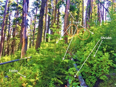
If you have ever attended one of the GDTA’s trail work trips you have likely helped to clear shrubby vegetation from the Great Divide Trail and its immediate vicinity. Shrubs are the woody perennial plants that are smaller than a tree with multiple permanent stems branching from or near the ground.
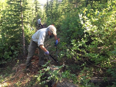
A stretch of GDT route about to be cleared (orange circles highlight flagging tape) identifying the trees (including saplings) to be cut, the shrubs to be pruned, and the forbs (herbaceous flowering plants)
At times, on a hot day amid the flies, you may have heard some volunteers cursing the so-called alders. You may have also heard a few choice words from thru-hikers battling their way through a dense thicket of what they are calling willows in as yet unmaintained sections of the GDT. But have you ever wondered if those shrubs they were blaspheming were really what they thought they were? While on the GDT, have you ever thought about what the presence or absence of certain shrubs can tell us about the environment through which the trail passes? Or have you considered what clues they provide that could aid the GDTA in route-finding and trail maintenance? If so, read on. The shrubs you see are not all alders or willows! Learning about them can reveal useful information affecting one’s safety on and enjoyment of the GDT, as well as the route’s viability and longevity.
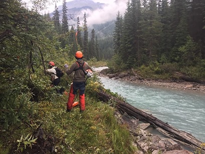
GDTA volunteers clearing shrubby vegetation from the GDT in the Blaeberry Valley, B.C.
Like all plants species, different types of shrubs have evolved to exploit different environmental conditions. Some like it wet; others prefer dry areas. One finds certain shrub species only in open areas; others thrive in shady areas. Some shrubs can tolerate windswept rocky alpine ridges. Others are only found in the deeper soils of valley bottoms. There are shrubs that help other plants to grow by improving the fertility of the soil. Other species exude toxins into the soil to repel their floral competitors. Certain shrubs produce delicious edible berries that attract bears and other wildlife; others generate leaves with medicinal qualities, and yet others wield spines that can cause serious allergic reactions in some people. It’s good to know what you’re dealing with and not to make assumptions when it comes to the more than 35 species of shrubs that can be found along the GDT (see Table 1).
However, identifying shrubs can be challenging. It’s helpful to get a good field guide like Alpine Plants of the Rocky Mountains by Kershaw, Mackinnon and Pojar (2017). There’s also the old classic, Trees, Shrubs and Flowers to Know in Washington and British Columbia (1996)by C.P. Lyons and Bill Merilees. However, you might not want to carry these while on the GDT. In areas where you can access the internet you can look up information on E-Flora BC[1] or Project Plant Identification Alberta[2]. You may also want to consider joining iNaturalist, one of the greatest citizen science initiatives ever launched[3]. While you learn about what you are seeing, you contribute useful information on what species can be seen along the GDT to a data base that scientists use to identify species, including rare and undocumented ones, and to develop species range maps.
Considering Shrubs in Route-Planning
In general, when route-planning, it’s best to find areas where the soil is relatively dry, coarse, and fairly well drained, like south or west facing side slopes, ridgetops, or alluvial fans. Shrubs that tend to grow on those slopes can include bearberry (kinnikinnick), shrubby cinquefoil, prickly rose, Western snowberry, chokecherry, Canada buffaloberry (soopolallie or soapberry), saskatoon (serviceberry), wax currant, black gooseberry, thimbleberry, all three species of the coniferous juniper (Rocky Mountain, common and creeping), Rocky Mountain maple[4], and rock willow. You want to avoid the wet soil areas in valleys characterized by most willow species, water birch, and red osier dogwood as well as cool, moist north or east facing mountain slopes thickly carpeted with green or Sitka alder, white-flowered rhododendron, false azalea, huckleberry and blueberry bushes.
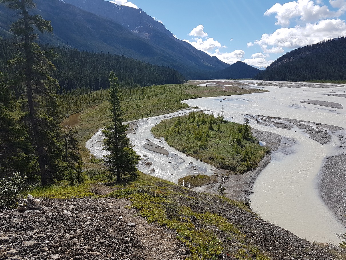
Where NOT to build a hiking trail – in the bottom of a wet valley covered in willows, Tonquin Valley, Jasper National Park, Alberta
While the presence of certain berry bushes may indicate a preferred soil type for trail construction and maintenance, trail planners need to determine if bears habitually frequent the area during the hiking season because of their need to access this important food source (e.g. huckleberry, Canada buffaloberry), and if so, consider routing the GDT away from that area.
When the berries are ripe, Canada buffaloberry attracts bears. Grizzly bears can eat up to 100,000 buffalo berries a day! Avoid building trail beside dense patches of this shrub
Considering Shrubs in Trail Maintenance
The shrub species that prove most challenging for GDTA volunteers to clear, primarily because of their dense prolific growth (especially after pruning), include the following:
many of the willow species found in wet areas, including smooth willow, which can carpet floodplains and other recently disturbed sites and Barratt’s willow, which forms dense fragrant thickets of balsamic resin-coated hairy-leafed bushes, and hybrids[5];
the two species of alder found in the Rockies, the green or Sitka alder[6], which forms dense thickets, especially in recently lightly burned areas with moist soils and some tree cover, and speckled alder (gray alder), which colonizes open boggy areas;
the red osier dogwood grows rapidly in a loose branching formation, with upright stems, horizontal branches, and densely growing underground stems in organically-rich soils along streams and other wet areas.
the white-flowering rhododendron, a deciduous, acutely branching shrub in the Ericacea (Crowberry/Heath/Heather Family) with erect-ascending stems to 150 cm tall, that grows densely along the margins of cool, moist coniferous woods and frequently along shady stream sides, bearing dainty clusters of mildly citrus-scented white flowers and attractive bright green leaves; and
the false azalea, another heath, with its loosely grouped, spreading branches, sticky stems, and small rusty bell-like flowers thrives in moist, shady areas like the steep slopes of mountains. The leaves and/or flowers emit an unpleasant skunky odour if crushed.
Nature Quiz #1: If your eyes were closed, how could you identify these two species?
GDTA volunteers pruning white-flowered rhododendron along the High Rock Section of the GDT
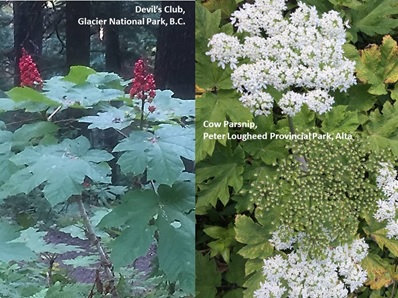
In addition, spiny shrub species (the junipers, especially common juniper, prickly rose, raspberry, wax currant, black gooseberry, creeping Oregon-grape) can pose problems if a significant amount of clearing proves necessary. Volunteers need thick canvas or leather gloves and protective clothing. While very rare along the GDT and only occasionally encountered in low, moist valleys on the B.C. side of the divide, one needs to be wary of the devil’s club. WorkSafe BC issued a toxic plant warning that details a severe eye injury one forestry worker received from this shrub. The spikes on this shrub’s stems and leaves prompt serious allergic reactions in some individuals. Besides the protective clothing and gloves, WorkSafe BC advises donning safety goggles and carrying tweezers and anti-inflammatory cream in case thorns get imbedded in one’s skin. One has to be careful not to mow down innocent plants with a similar-shaped leaf (minus the prickly bits) like the cow-parsnip, a valuable food plant for wildlife.
Nature Quiz #2: Which is the forb? Which is the shrub? How should you prune each of them?
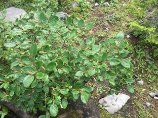
In the high elevations through which the GDT passes, many shrub species grow slowly (the junipers, shrubby cinquefoil, Rocky Mountain willow) and others never get tall (mountain heather[7], bearberry, grouseberry, crowberry, creeping Oregon-grape, bog birch, dwarf birch, rock willow), and thus do not require a lot of pruning.
The rock willow does not grow very quickly or very tall, so it needs little to no pruning.
Considering Shrubs as You Hike the GDT – There’s More than Meets the Eye
Wildlife need their Veggies, Too
Ironically, some of the shrubs GDTA volunteers grumble most about are essential food sources for the hoofed mammals (ungulates) and other wildlife that we enjoy watching from the trail. Mule deer (Odocoileus hemionus), elk (Cervus canadensis) and moose (Alces alces) like to browse on willows and red osier dogwood. Smooth willow provides wintering ungulates with a rich source of calcium and phosphorous. This species of willow constitutes a large part of the diet for snowshoe hares (Lepus americanus) in the Rocky Mountains, and is vital for beavers (Castor canadensis). White-tailed ptarmigan (Lagopus leucura) eat the buds and catkins of dwarf birch and songbirds eat insects attracted to the catkins.
Evidence of winter browsing on red osier dogwood
Alder is extremely valuable for wildlife in the vicinity of the GDT. Elk munch on the tender young shoots, while white-tailed deer (Odocoileus virginianus) and mule deer feed on the leaves and twigs. Muskrats (Ondatra zibethicus), snowshoe hares, and red squirrels (Sciurus vulgaris) also eat alder twigs and leaves, while beavers eat the bark. The seeds, buds, and catkins provide an important source of food in winter for numerous song birds, including redpolls, pine siskins (Spinus pinus), crossbills, finches, grosbeaks and sparrows, as well as some game birds. Mountain alder is an important component of white-tailed ptarmigan winter forage. In some areas, moose and caribou (Rangifer tarandus) browse alder in the winter. The caterpillars of several species of butterflies feed on Sitka alder. Its catkins offer a source of pollen for honeybees, native bees, and other insects during the spring.
Hoary comma caterpillars feed on the leaves of alder and willow and adults rest on alder leaves
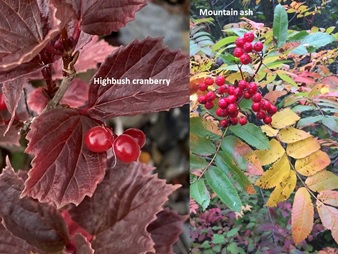
Canada buffaloberry foliage provides a moderate quality browse for mule deer, white-tailed deer, bison (Bison bison), elk, and snowshoe hares (Lepus americanus) especially when the plants are dormant in winter and fall. Elk, deer, moose, caribou, beaver, and snowshoe hare feed on the foliage of highbush cranberry and Sitka mountain ash, both evident in moist valleys on the west slope of the Great Divide such as the Blaeberry in Section D of the GDT.
Both highbush cranberry and mountain ash are important for wildlife
Primarily grazers of grass, Rocky Mountain bighorn sheep (Ovis canadensis) eat the fresh leaves and buds of willows, saskatoon, and Rocky Mountain maple. Mule deer and elk also dine on the leaves and twigs of saskatoon. Other shrubs preferred by mule deer include Western snowberry, thimbleberry, and chokecherry. They even eat prickly rose and Oregon grape. Amazingly, elk nibble on common juniper despite its coarse spiky needles.
Sometimes, a species’ route to its salad bowl is not that obvious. Wildlife biologists recognized that although mountain alder was a principal component in mountain goat (Oreamnosamericanus) foraging areas, goats did not appear to browse on it. They eventually learned that alder shrubs provide ground cover that lessens snow accumulation, making desirable species like lady fern (Athyrium filix-femina) more accessible to mountain goats.
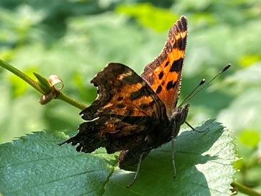
Just Desserts
Floral nectar and even the sap from shrubs provide vital quick energy fuel for a variety of species. Bees frequent wild roses and wolf willows. Butterflies, including the tiny spring azure (Celastrina ladon), consume the nectar in the inner flowers of the high bush cranberry, as do ants. The hoary comma butterfly (Polygonia gracilis) prefers the flowers of wild gooseberry and currant bushes. Mourning cloak butterflies seek their sustenance from willow catkins. Western snowberry flower nectar attracts bees, flies, ants, butterflies, moths, and hummingbirds.
Native bumblebee seeking nectar from a prickly rose flower pollinating the flower in return
Porcupines (Erethizon dorsatum), red squirrels, snowshoe hares, mice, and voles nibble at thin-barked shrubs to access the sweet sap. Hummingbirds and red-naped sapsuckers (Sphyrapicus nuchalis) have been observed feeding on water birch sap and the insects attracted to the sap.
Berry Nice
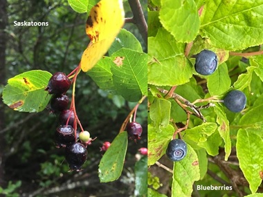
The many shrubs with edible fruits (berries, rose hips, etc.) provide a staple food source for bears and other wildlife as well as occasional sustenance for hungry hikers[8]. The berries of Canada buffaloberry are well-known as a highly favored food of grizzly bears (Ursus arctos) and black bears (Ursus americanus), but also sustain ruffed grouse (Bonasa umbellus). Highbush cranberries get eaten by bears, small mammals, and birds. Thimbleberries sustain grouse, grosbeaks, jays, robins, thrushes, towhees, waxwings, and sparrows. Thimbleberries are also popular with bears, marmots, squirrels, chipmunks and other rodents. Wolves (Canis lupus), coyotes (Canis latrans) and red foxes (Vulpes vulpes) consume blueberries, huckleberries, and saskatoons to supplement their meat-based diet.
However, berries can offer more than calories. In late fall, bears seek out bearberry. Eating its berries and leaves creates a unique blockage in their digestive system that prevents the bears from defecating during their extended sleep during the winter. Don’t try this at home!
The fleshy cones of junipers also serve as the primary source of food in the winter for the Townsend’s solitaire (Myadestes townsendi). These gray birds defend their winter territories in the mountain valleys by belting out a beautiful song (now if only humans would do that). Interestingly, the essential ingredient in gin is the addition of these erroneously named juniper “berries”. Gin originated in the Netherlands in the Middle Ages and the name gin came from the Dutch word for juniper, which is ‘genever.’ However, before you grab a handful of these light purple berry-like cones from female junipers (that’s right, there are female and male junipers) in hopes of getting a gin buzz as you walk the GDT, you should know that the “berries” can be toxic to humans if ingested.
Nature Quiz #3: Which one of these shrubs bears cones and which one bears fruit?
Shrub Security
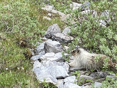
Beavers use the stems of willows and alders to build their lodges and dams. Willow, alder and red osier dogwood thickets provide thermal and hiding cover for big game and other wildlife, as well as nesting habitat for many small birds.
Hoary marmot using willow as cover, Harvey Pass, Banff National Park
Dense water birch thickets provide excellent thermal and hiding cover for various wildlife species. As it often overhangs streams, water birch provides important shade benefiting native fish that have evolved in cold water. Linear water birch stands provide protective travel corridors for wildlife. Water birch stands are considered fair cover for elk and good cover for white-tailed deer, mule deer, small mammals, and birds. Water birch provides important habitat for chickadees, vireos, and other songbirds.
Thick patches of Western snowberry and chokecherry provide cover for small mammals and nesting sites for birds. Common and Rocky Mountain juniper also provide secure hiding places for wildlife. Even highbush cranberry provides cover for small mammals and birds.
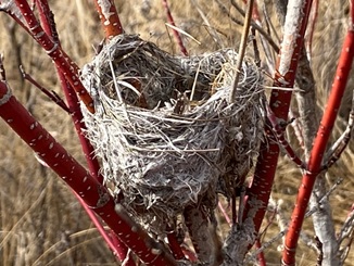
Bird nest in red osier dogwood
Shrub Services
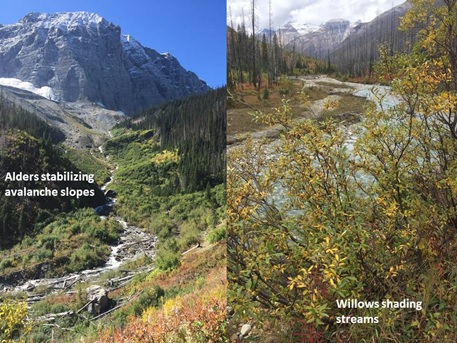
Besides benefiting wildlife by providing food and cover, shrubs provide a wide variety of ecosystem services that foster life support systems like the water cycle, carbon cycle, etc. Willows provide shade to streams, keeping the water temperatures suitable for a large number of aquatic species. The shade benefits terrestrial riparian plants and animals, too. Willows slow water flow and allow the ground to absorb water and nutrients. They stabilize stream banks. They provide construction material for beavers and their dams, which in turn sustain the water table and benefit other ecosystem processes.
Examples along the Great Divide of the ecosystem services shrubs provide (Left: below Floe Lake, Right: along Tokumn Creek, both in Kootenay National Park, B.C.
Likewise, Sitka alder stabilizes slopes and stream banks and controls erosion on disturbed, nutrient poor sites. As a result, this easy to establish, deciduous shrub has proven useful in land rehabilitation efforts where it has been successfully planted for acid, coal, placer, and copper mine spoil reclamation and soil enrichment. The species can also be used strategically as a conservation buffer by planting it in hedgerows or the shrub row of field windbreaks.
As host to symbiotic nitrogen-fixing bacteria in its roots, Sitka alder is particularly important for improving forest site productivity and has been used as a companion or nurse shrub in some conifer plantations. A US Forest Service study showed that alder added 55 lbs of nitrogen per acre per year to the soil.Canada buffaloberry also has nitrogen-fixing bacteria in their root nodules that allow them to grow in marginal soils. Studies show that this shrub may also concentrate mercury from soil. Wolf willow, not a willow at all but a relative of Canada buffalo-berry, has a similar partnership with nitrogen-fixing bacteria in its root nodules and therefore enriches the soil.
The soil-enriching wolf willow bears fragrant flowers but primarily reproduces vegetatively through suckering
Although they can spread vegetatively by sending up suckers, wolf willows do not form a closed canopy and thus compete little with surrounding vegetation. Other shrubs like the junipers, bearberry, Western snowberry, and white-flowered rhododendron actually repel competitors by exuding chemicals into the soil that discourage the growth of other plants. This keeps plants spaced apart so that moisture and soil nutrient resources do not get used up too quickly.
Indigenous Traditional Ecological Knowledge Values Shrubs
The Indigenous peoples whose traditional territories include the current route of the GDT[9] recognized and valued the different types of shrubs of the Rocky Mountains. Indigenous belief systems accord respect for all aspects of Nature, including shrubs. They see other lifeforms as their kin and their role as one of caretaking, sustaining, and not taking for granted species that provide sustenance for human beings. Traditional harvesting of botanical resources along with ritual and ceremonial practices reflect these respectful interconnected human-plant relationships. With greater legal recognition of the Rights of Indigenous Peoples, many First Nations communities in the vicinity of the GDT are restoring their traditional cultural practices and languages, renewing their ties to the land and water, and relearning and applying their extensive ethno-ecological knowledge and wisdom, including how they utilized various shrubs[10].
Indigenous people used parts of willows, including the species found near the Great Divide, for medicinal purposes, basket weaving, to make bows and arrows, and for building animal traps. They also had many practical uses for alders. They derived a red or brown dye from the bark that they used to color wool and tanned animal skins. They used Sitka alder, which is known for being sticky and sweet smelling, as a perfume. They burned alder as firewood and preferred it for smoking fish. They used the hard wood to make snowshoes, bows, and spoons. Traditional medicinal uses included using the inner bark or ointments made from it to treat skin problems such as wounds, skin ulcers, and swellings. They also applied fresh scraped bark juice to the skin to relieve itching from rashes. They used alder to treat digestive issues (both constipation and diarrhea). Leaf decoctions helped treat burns and swollen wounds. Alder roots contain a lot of tannins, so they were boiled and drunk as an astringent. Cold remedies included drinking a decoction of stems, chewing dried stems, and placing dried stems in the nose. They ate the bitter alder catkins and young buds raw or cooked. Although the inner bark was edible, they dried and aged alder bark before consuming it to avoid adverse reactions (i.e., vomiting).
Many First Nations sustainably managed their land by periodically burning areas to foster the growth of berry plants. They often picked berries by breaking off branches and beating the stems with a stick to knock off the fruit. This “speming” method also pruned the shrubs, thus encouraging new growth and more berries in subsequent years. Berries remain an important staple traditional food for Indigenous people. They harvest more than 20 species of berry bushes, including thimbleberries, blueberries, soapberries, huckleberries, and cranberries. The key species for the Ktunaxa, Secwepemc, and Blackfoot nations continues to be the saskatoon.
Wild berries from the Rocky Mountains provide a traditional staple food for Indigenous people
Canada buffaloberries were also traditionally harvested by several First Nations by using a stick to beat the bush over a piece of canvas or a hide. Dried berries were mixed with dried buffalo meat to make pemmican or added to stews and puddings. These bitter berries were also used medicinally to treat flu, indigestion, and constipation. A juice made from the berries was considered an effective treatment for acne, boils, and gallstones. The berries were also crushed and boiled for use as liquid soap and shampoo. A decoction of the bark was used to relieve eye soreness. The berries were highly valued and traded for with many tribes in areas that lacked Canada buffaloberries.
Indigenous people still cook fresh Canada buffaloberries to make syrup, sauce, or jelly. Nowadays, they may be whisked into a foamy froth and then combined with copious amounts of sugar to make a highly sought-after treat that is still popular today. Traditionally, the berries were whisked with the inner bark of Rocky Mountain maple or with thimbleberry leaves, and thimbleberries were added as a sweetener.
Rich in vitamin C and iron, the bitter berries of the Canada buffaloberry taste somewhat sweeter after several freezes or when dried. The bitter taste of the berries is due to the prevalence of saponins, foam-producing compounds, which can irritate the stomach causing diarrhea and cramps if eaten in large quantities.
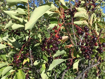
Most Indigenous peoples ate chokecherry fruit. They collected the cherries in the fall and dried them, often with the stones left in. They made handles from chokecherry wood. They shredded the bark and used it for decorating basket rims. They made a tonic from the bark for regaining strength after childbirth. Many still use chokecherries for making wine, juice, syrup, and jelly.
Indigenous peoples harvested ripe chokecherries, dried them, and used them to make pemmican
Wolf willow fruit is mealy and dry, but some First Nations still utilized them. The Blackfoot peeled and ate the berries or mixed them with grease and stored them in a cool place. This was eaten as a confection or added to soups and broths. The berries were sometimes mixed with blood or sugar and cooked for food. A strong solution made from the bark was used to treat children suffering from frostbite.
The bark of wolf willow was used to make strong fibre baskets useful for collecting berries. Bark was also used to make cords or ropes. Native people discovered that wolf willow had a bad smell when burned. Those who used it for firewood were chided for being lazy. Nevertheless, an essential oil made from wolf willow is currently in demand for aromatherapy.
Wolf willow berries were used by Blackfoot Natives to make seed necklaces. They boiled the berries to remove the fleshy part revealing pointy dark brown seeds with yellow stripes. The seeds were strung onto necklaces or used to decorate the fringes on clothing. When the first European settlers arrived, the new arrivals learned the art from the Indigenous women. Wolf willow seed necklaces became a popular gift to send home.
For indigenous people, harvesting wild shrubs and other plants involves much more than simply taking. A complex protocol, established over thousands of years, governs the process. Two key tenants guide the practice: respect for nature, and respect and caring for each other. Traditionally, many First Nations sang special songs as they got ready for harvests. Often they made an offering of kinnikinnick or scattered some of the first harvest nearby. Another custom involved sharing the first harvest with others in the community.
Shrub Aesthetics
Prickly rose bush near Johnson Lake, Banff National Park, Alberta
If we take the time to look and appreciate, flowering shrubs like the mountain heathers, prickly rose, shrubby cinquefoil, white-flowered rhododendron, bracted honeysuckle, and saskatoon, as well as species with interesting foliage like the rock willow, wolf willow, red-osier dogwood, Rocky Mountain maple and Rocky Mountain juniper, inspire us with their beauty and enhance our enjoyment of the GDT. As summer wanes and autumn begins, the leaves on the deciduous shrubs along the GDT beguile our eyes with their intense scarlet, orange and gold hues.
Hiking past a colourful Rocky Mountain maple shrub below Ball Pass on the GDT in Kootenay NP, B.C.
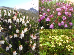
In 1841, Sir George Simpson, Governor in Chief of the Hudson Bay Company, crossed the Great Divide in the course of his journey around the world. On reaching the Pass that now bears his name, the adventurous Scot was surprised and delighted to discover mountain heather and wrote about their beauty in his book, Narration of a Journey Around the World. Sometimes, when we are hard at work clearing trail, or on a mission to hike through an area as quickly as possible, we lose sight of that simple pleasure of appreciating the beauty around us. More often than not, we might notice an amazing gnarly old tree or a patch of colourful wildflowers. I encourage you to also see the shrubs along the GDT, and take the time to appreciate their value to wildlife, ecosystems, and Indigenous peoples, as well as their aesthetic contributions.
The three species of mountain heathers found along the GDT are iconic alpine flora
Is it an Alder or a Willow?
So, back to the start of this article, although the shrubs you see along the GDT are not ALL alders and willows, there are indeed a lot of alders and willows that need to be cut when maintaining the GDT and other trails. Before that work gets done, hikers and equestrians may experience some frustrating bushwhacking experiences, and GDTA volunteers may find the shrub clearing in certain areas very challenging. In both situations, the odd cuss word might turn the air blue. But wouldn’t it still be interesting to know if the source of annoyance is a thicket of alders or willows? Read on, for quick field clues to tell them apart.
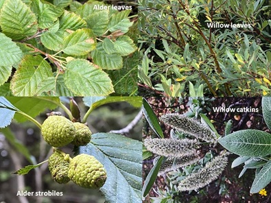
Alder shrubs belong to the Birch Family of plants and their leaves look birch-like, i.e., they are alternate, deciduous, smooth, finely-toothed, oval with pointed tips, 4-10 cm long, with distinct veins. Unlike birch tree species, the leaves of alders retain their chlorophyll as long as possible. They thus remain green until they drop from the tree, at which time they turn brown and decompose. The alder has to remake new chlorophyll for its leaves each spring. Alder stems are less flexible than most willow stems and are covered with white dots. Alders bear distinctive male and female catkins on the same bush. The female catkins are on stalks and look like cones. There are several in a cluster. They start off green, and as they mature, turn into brown, woody fruits called strobiles, which bear seeds. The strobiles stay on the bush after the seeds have been released and throughout the winter, making for easy identification.
Willows shrubs belong to the Willow Family of plants. Their leaf shape varies, but none of the willow species found near the Great Divide have birch-like leaves. Willow leaves are alternate, simple, usually long and narrow, and pointed at both ends. Willows reabsorb their chlorophyll and store it in their roots, leaving the remaining yellow, orange and/or red leaf pigments in their leaves, creating lovely fall foliage. Willow stems are smooth, greenish, long, thin and very flexible, especially in new growth. Willows produce catkins that are soft, silky, and silvery before leaves appear in the spring. Catkins remain on the bush after the leaves emerge. As the flowers develop and the anthers form, they appear yellow or pink. Willow species vary greatly in appearance. Some species hybridize, making identification to the species level challenging.
Alders can be distinguished from willows by looking at their leaves, stems, and catkins
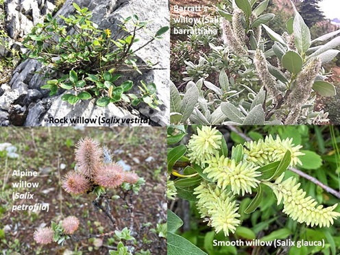
Four common willow species found near the GDT include the alpine, smooth, Barratt’s and rock willows
Answers to Skill-Testing Questions for Shrub Connoisseurs
Nature Quiz #1:Blind Test – If your eyes were closed you could tell which species is which by your sense of smell. If you gently crush the leaves or flowers, the one that has a citrus scent is the white-flowered rhododendron and the skunky-smelly one is the false azalea.
Nature Quiz #2:Forb or Shrub? – While the leaves look similar, Devil’s Club is a shrub and has sharp spines. It needs to be carefully pruned well away from the trail. Cow Parsnip is a forb (herbaceous flowering plant) that dies back each year. It has no spines and just needs to be cleared from the tread and immediate corridor.
Nature Quiz #3: Cones or Fruit? – The juniper, being a conifer, has its seeds inside fleshy cones (misnamed juniper “berries”), while alder, being a deciduous shrub, bears fruit called strobiles (misnamed an alder “cone”). Are you confused yet? Nature fascinates and confounds us all.
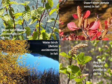
Three species of birch shrubs can be found in wet areas near the Great Divide
Table 1. List of the most common shrubs found along the GDT.
Common Name
Scientific Name
Alpine willow/Rocky Mountain willow
Salix petrophila
Barratt’s willow
Salix barrattiana
Bearberry/Kinnikinnick
Arctostaphylos uva-ursi
Black crowberry
Empetrum nigrum
Black elderberry
Sambucus cerulea
Black gooseberry
Ribes lacustre
Black huckleberry
Vaccinium membranaceum
Blueberry (oval-leafed)
Vaccinium ovalifolium
Bog birch
Betula glandulosa
Boulder raspberry
Rubus sp.
Bracted honeysuckle
Lonicera sp.
Canada buffaloberry/Soopolallie
Shepherdia canadensis
Chokecherry
Prunus virginiana
Common juniper
Juniperus communis
Creeping juniper
Juniperus horizontalis
Creeping Oregon-grape
Mahonia aquifolium
Devil’s club
Oplopanax horridus
Dwarf birch
Betula nana
Dwarf red raspberry
Rubus pubescens
False azalea
Menziesia ferruginea
Grouseberry
Vaccinium scoparium
Highbush cranberry
Viburnum trilobum
Pink mountain heather
Phyllodoce empetriformis
Prickly rose/Wild rose
Rosa acicularis
Red osier dogwood
Cornus stolonifera/ Cornus sericea
Red raspberry
Rubus idaeus
Rock willow
Salix vestita
Rocky Mountain juniper
Juniperus scopulorum
Rocky Mountain maple/Douglas maple
Acer glabrum
Saskatoon/Serviceberry
Amelanchier alnifolia
Shrubby cinquefoil
Dasiphora fruticosa
Sitka/Green/Slide/Mountain alder
Alnus alnobetula/Alnus crispa/Alnus viridis
Sitka mountain ash
Sorbus sitchensis
Smooth willow
Salix glauca
Speckled alder/Gray alder
Alnus incana
Thimbleberry
Rubus parviflorus
Water birch/Rocky Mountain birch
Betula occidentalis
Wax currant
Ribes cereum
Western snowberry
Symphoricarpos occidentalis
White-flowered rhododendron
Rhododendron albiflorum
White mountain heather
Cassiope mertensiana
Wolf willow
Elaeagnus commutata
Yellow mountain heather
Phyllodoce glanduliflora
Jenny by a common juniper on Steamboat Mountain above the Upper Columbia Valley north of her home in Invermere, B.C. (Photo by Ian Hatter)
[1] E-Flora BC is an online biogeographic atlas of the flora (vascular plants, bryophytes, lichens, and algae), fungi and slime molds of British Columbia. See https://ibis.geog.ubc.ca/biodiversity/eflora/
[3] One of the world’s most popular nature apps, iNaturalist helps you identify the plants and animals around you. Get connected with a community of over a million scientists and naturalists who can help you learn more about nature! iNaturalist is an easy-to-use database that records worldwide biodiversity. iNaturalist users worldwide upload photos of wild living things to the site that can be used as scientific data. See https://inaturalist.ca/home
[4] A variety of Rocky Mountain maple (Acer glabrum) found on the west side of the Great Divide to the Pacific Coast is called Douglas maple (Acer glabrum, var Douglasii).
[5] Many willow species hybridize, making identification challenging.
[6]Alnus alnobetula is the correct scientific name even though in some texts, this species is called Alnus viridis or Alnus crispa, which are illegitimate botanical names. On the B.C. side of the great divide, it is usually called Sitka or slide alder whereas In Alberta, it is usually called green alder or mountain alder. It can be confusing as Alnus incana usually known as speckled alder is also sometimes called mountain alder.
[7] The term “mountain heather” describes a group of low growing plants from the Heath family of plants (the Ericaceae). Other common names include moss-heather, moss-bush, Cassiope, bell flowers, or heath. Among the most representative shrubs of high mountain habitats, mountain heathers form low trailing sub-shrubs or mats as an adaptation to the harsh environments of the upper elevations. Besides hugging the ground, other qualities that allow these plants to exist under harsh alpine conditions include having glandular hairs on their herbage for warmth; scale-like evergreen leaves for moisture retention, and wind-resistant flowers that are short and stiff or leathery and bell shaped.
[8] A future article will help identify the edible as well as toxic berries along the GDT.
[9] Indigenous People have called the Rocky Mountains home since time immemorial and used the passes along the Great Divide as trading and hunting routes. Today, the GDT passes through the traditional territories of the Blackfoot Confederacy, Tsuut’ina, Ĩyãħé Nakoda, Cree, Lheidli T’enneh, Ktunaxa, Secwepemc, Sinixt, and Métis.
[10] A useful resource is the book Edible and Medicinal Plants of Canada by MacKinnon, Kershaw and Arnason (2016).
The Great Divide Trail Association has set several ambitious goals for 2022. This year we will be holding 7 trail building trips on the High Rock Trail (HRT) as we prepare for the official opening ceremony of the HRT on July 22! We are excited to announce the return of the GDTA Signature Trip as one of the HRT trips this summer, offering volunteers a more “luxurious” camp experience with all meals provided and prepared by our onsite chef. We will also be holding one bridge building trip on the Original GDT, one trip to begin restoring the historic Collie Creek Trail, and returning to the Jackpine to finish what we started last year!
We continue to build important relationships with other stewards and decision makers of the lands that the GDT travels through. We held several exciting virtual events already this year, and our first in-person event in the past two years. And we continue working hard behind the scenes to secure robust, diverse revenue streams to support and expand our capacity for operations.
The GDTA is a membership organization built by the support of people like you. Members are the foundation of our organization, so it will come as no surprise that increasing GDTA membership is one of our highest priorities in 2022. A diverse and large membership creates the opportunity for the GDTA to accomplish all of our goals and to show land stewards and decision makers that the GDT is important to many people. Please join us by becoming a member of the GDTA.
Life’s Many Purposes, Situations, and Stages
GDTA members range from teens to those in their 70’s and beyond. Thus, as might be expected, there are a variety of reasons that they have joined the GDTA. Some are volunteers, some are thru-hikers, some are day-trippers, some are equestrians, some hiked the trail many years ago, while some dream about hiking the trail in the future. They come from all walks of life. Undoubtedly, their life goals, purposes, and situations cover a broad spectrum. All stages of life are represented from those just beginning their adulthood to those that are retired. Yet they have all found a reason to join the GDTA.
The GDT embodies a connection to each other and to nature through the passion of hikers, equestrians, volunteers, supporters, and government organizations. Common purpose unites us and creates a community, all pursuing the vision of the GDTA. On the Great Divide, we are all connected by the Trail.
Reasons to Become a GDTA Member
Given the GDTA’s diverse membership, there are a variety of reasons that people choose to join the GDTA. Here are some of the common reasons for becoming a member:
Canada’s Rocky Mountain wilderness is important to preserve
Discounts given to members by GDTA corporate supporters
Gratitude for trail maintenance
Join trail crews
Meaningful volunteer work
Voting status at meetings of members of the GDTA and Eligibility to serve on the GDTA Board of Directors
To “Pay it Forward”
Canada’s Rocky Mountain Wilderness is Important to Preserve
Canada’s Rocky Mountain wilderness is one of the most beautiful, pristine, and wild places on earth. As time marches on there are fewer and fewer places like this. Thus, preserving it – its animals, plants, rivers, glaciers, ecosystems, and all the rest of its unspoiled wonder, is important beyond words. The GDTA’s mission is about promoting and encouraging the use of the GDT in a manner consistent with the conservation and preservation of the scenic and wilderness value of the Rocky Mountains of Canada. The GDT creates the opportunity for people to experience the beauty and wonder of the Canadian Rockies wilderness without imposing on its natural capital. It inspires them to care about it and work to protect it for generations to come.
Views from Surprise Pass
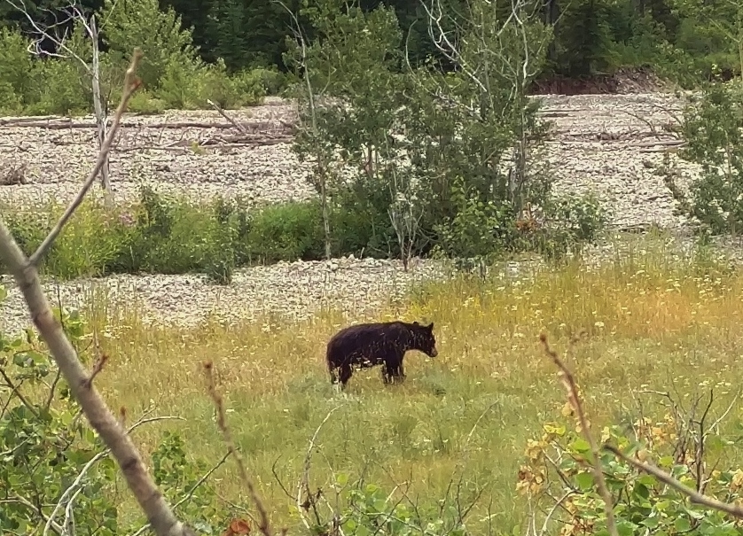
Black Bear, One of Many Species Large and Small, in the Mountains
The vehicle to accomplish the GDTA’s mission is advocating for preservation of the GDT, and with it preservation of the wildlands that it runs through. This advocating is done through relationships with the stewards and decision makers of these lands – Parks Canada, Alberta Parks, BC Ministry of Forests, Willmore Wilderness Foundation, and others. Realistically, demand, and therefore membership numbers, is a factor in decisions that get made. For example, look at all the frontcountry infrastructure investments being made by Parks Canada (vs backcountry funding). Many, many more people use the frontcountry infrastructure and so that is where more investments are made. The point of all this is that for the GDTA to be most effective in their wildlands preservation efforts, the more GDTA members we have, the more the decision makers see that demand for wildlands preservation is real, and is there, and is important.
Our members believe in the GDTA’s mission to preserve our mountain wilderness. In fact, we have members that have joined the GDTA solely for this reason. One doesn’t need to be a hiker, past hiker, or equestrian to believe in this mission – anyone can. By joining the GDTA, one’s presence in the GDTA’s growing organized and visible community, translates into public demand for wilderness preservation that is recognized by decision makers through the GDTA’s advocacy efforts. In other words there is strength in numbers. Your GDTA membership adds to this strength and so helps preserve the precious Canadian Rocky Mountain wilderness.
In addition to this overriding very important reason to join the GDTA, there are many other very good reasons to become a member. Please read on for a discussion of these other reasons that have attracted our members.
Discounts
The GDTA has several corporate supporters that are industrious, small businesses whose products and services are all about hikers – gear, lodging, food, resupply, information sources, and memorabilia. Like us, they are outdoors enthusiasts and believe in taking care of and preserving our precious mountains and nature. These supporters believe in the GDTA and its mission to maintain and preserve the wild Canadian Rocky Mountains for future generations. To show their support, they very generously provide discounts to GDTA members.
These discounts are particularly interesting to hikers and are quite often a reason that they join the GDTA.
GDTA Members also get discounted fees for GDTA events, allowing members to connect more easily to the growing Great Divide community.
Gratitude for Trail Maintenance
The GDT can be a rough trail to hike – challenging weather, wildlife, river crossings, long distances between resupplies, infrequently or unmaintained trail, bushwhacking, route finding, and so forth. Well maintained trail can make a huge difference. Each year, dedicated Great Divide Trail Association volunteers head into the woods with picks, shovels, saws and spirit to rebuild washed-out bridges, cut away fallen trees, and restore eroded portions of the trail. We recruit young and old to give time and energy to fix what needs to be fixed from Waterton to Kakwa. GDTA volunteer trail crews devote hundreds of hours to keeping the trail open. It is only with the support of members and volunteers that the Great Divide Trail experience is possible. Many a GDT hiker fondly remembers coming upon cleared trail and sometimes trail crews at work. Here’s an example in the notorious Jackpine River valley.
Out of gratitude for the GDTA’s trail maintenance work, and a desire to support its costs, many GDT hikers become GDTA members to show their thanks.
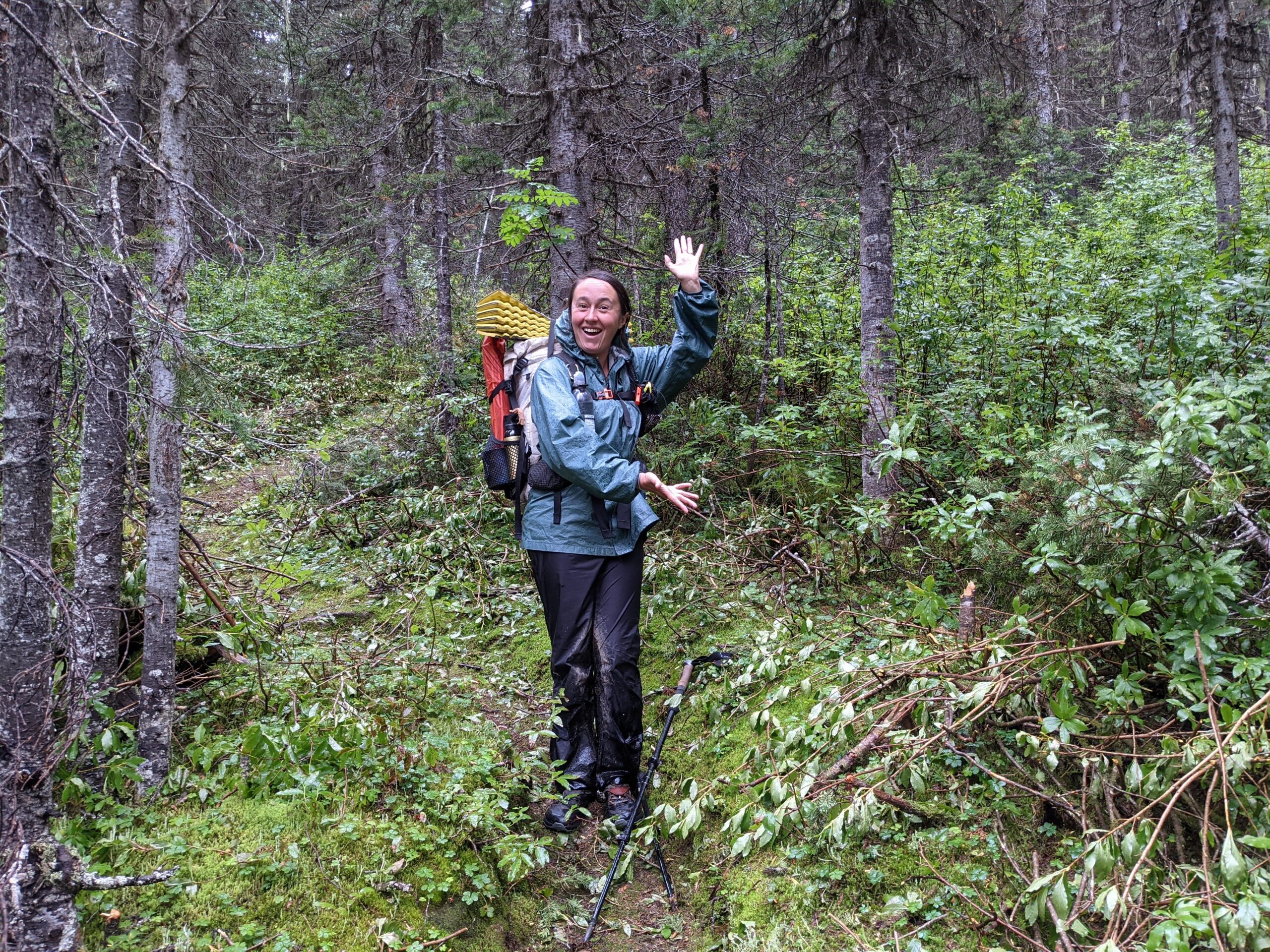
Happy hiker on newly cleared trail, after way too much cold, wet, drizzle, and bushwhacking.
Join Trail Crews
Additionally, some hikers take their gratitude to the next level by not only joining the GDTA, but also becoming a volunteer trail crew member themselves. However, usually this is not only about gratitude. Camaraderie is another big reason for joining a trail crew. Satisfaction in seeing ones efforts make a difference to the GDT is also meaningful to many. Projects can include building, maintaining and improving trail tread, removing fallen trees, repairing and building trail structures, brushing and clearing vegetation, as well as blazing and signing the trail. Living outdoors and sleeping under the stars in the camps is an attraction. To some extent trail crew trips are “summer camp for adults”.
Looking for a meaningful and fun outdoor experience with others leads many hikers, past hikers, and even some non-hikers to join the GDTA so that they can participate on trail crew trips.
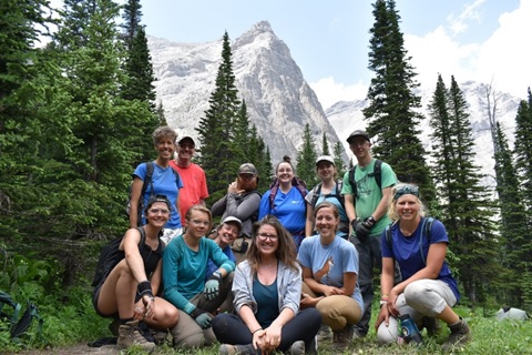
Quick break for happy trail crew photo in this gorgeous place.
Meaningful Volunteer Work
The GDTA is volunteer organization. Over 100 volunteers each year not only man the trail building & maintenance crews, but also perform the many other organizational duties. These include advocating for official recognition and protection of the GDT, ensuring financial capacity of the organization, public outreach, engagement and education, events, our website and social media, newsletter articles, the Board and its committees. Thus, all sorts of skills in our GDTA members are appreciated. The GDTA has a lot going on and is an exciting, congenial place to volunteer.
As time in a person’s life frees up, for example in (but not limited to) retirement, many people look for meaningful volunteer work and know of the GDTA. This is a reason to be a GDTA member for several of our members.
Meaningful GDTA volunteer work for all abilities and interests.
Pay it Forward
As one’s life moves forward, if one is fortunate, along the way valuable assistance gives one a boost occasionally. It can be that trail angel that gave you a lift, it can be that relative that gives you a rent free place to live when you are starting out, or someone who loans you something you are in need of, and so on. Later on, if good fortune allows one, you may have an urge to assist someone else in need, and do it. “Pay it forward” as they say.
This urge to repay one’s previous good fortune, to a worthy recipient is another reason some join the GDTA. In the GDTA they see a volunteer group with a mission to preserve, maintain, and advocate for the GDT, so that its mountain wilderness is there for future generations to enjoy and appreciate. And so they become a GDTA member, volunteering and supporting the GDTA, to repay their good fortune of enjoying this mountain wilderness, to the next and future generations.
Views from Amiskwi Ridge
Patron of the Canadian Rocky Mountain Wilderness Experience
As a GDTA member – hiker, past hiker, equestrian, or none of the above, regardless of your reason(s) for joining the GDTA, you are contributing to the preservation of the Great Divide Trail and its wilderness experience in the Canadian Rocky Mountains (as highlighted above in the first reason to become a member). With your:
modest membership dues and
addition to our growing membership community
you are not only a GDTA member but part of something bigger – you are a
Patron of the Canadian Rocky Mountain Wilderness Experience
in the glorious, beautiful, pristine, wild Canadian Rockies. As a patron you are part of a community making a difference to ensure this treasure is there for future generations to come.
Howse Floodplain
We need you! Please consider becoming a member of the Great Divide Trail Association today.
How do you become a member?
We offer three types of membership. Click on one of the links below:
With much gratitude, the Great Divide Trail Association wishes to thank all those who donated to our 2021 Trail Supporter Campaign, and all our donors who have contributed in other ways.
The 2021 Trail Supporter Campaign was the GDTA’s 2nd annual Trail Supporter Campaign. It was kicked off on Giving Tuesday, November 30, 2021, with a donation goal of $5,000. Surprisingly, this goal was reached in only one week! Thus GDTA planners, especially those involved with trail building and maintenance needs, put their heads together to identify needed projects that may have been out of reach due to budget constraints. They identified the severely overgrown and remote Jackpine Valley as a possible project in 2022 with the addition of more funds, and tallied up how much this project would cost. With some debate and hesitancy about aiming too high, in early December the Trail Supporter Campaign goal was modified to $12,500 to cover the Jackpine Valley project.
To spread the word, a social media campaign greatly helped the effort throughout December. Periodic posts were made to the GDTA Facebook page and Twitter account. Status reports were emailed to GDTA Subscribers. This was a great effort by the GDTA digital media team, and campaign leader, Meaghan Underhill.
With this in mind though, the true stars of this campaign were all the Donors. Large and small, donations amazingly added up to more than $21,000! Far above any amount imagined when the Trail Supporter Campaign started. Who would have thought?! And to top it off we received several comments on our donation forms that were very inspirational:
“Keep up the stewardship of this amazing trail!”
“Thanks for all the great work you do!!!!!”
“GDT class of 2021! Loved the trail and happy to support its maintenance”
“Thanks for all the hard work you do!!!!”
“Thank you for all the tremendous work you do … You’re all amazing!”
“Thanks for the great work on trail building.”
“Thank you for all the behind the scenes work you are doing to create a trail that is changing lives…”
“Hey, I hope this small donation helps with all of these amazing projects. I love the GDT so much!”
“We hiked Waterton to Banff summer 2021. The trail is an amazing legacy for Canada. Thanks for protecting it.”
“I had an incredible time thru-hiking the trail in 2020! Thank you for all your fantastic work!”
The Great Divide Trail Association, all its volunteers, trail builders, bridge builders, trail maintenance crews, hikers, and equestrians say:
THANK YOU DONORS ONE AND ALL!!!
You have enabled many worthy projects to continue building and maintaining the Great Divide Trail. A very ambitious trail building and maintenance season is being planned for this coming summer. It will involve multiple projects in Alberta and BC. Our trail projects are becoming increasingly complex and multidimensional – for example, helicopter transport into the extremely remote Jackpine Valley. Additionally, these funds support our emerging youth program. Similar to last year, we will continue with safety protocols as necessary to protect our volunteers as the COVID-19 pandemic wears on.
High Rock Trail, AB – We still have some work to finish and officially open the new HRT in 2022!
David Thompson Heritage Trail, BC – Continue rehabilitating the 13 km of floodplain susceptible trail, and maintaining 2 bridges.
Collie Creek Trail, BC – Restoring and preserving this historic connection between Howse Pass and Amiskwi Pass.
Original GDT, AB – Maintaining the original 100 km of the GDT, including replacing up to four old and damaged bridges.
Youth Trail Trip Initiative – We are excited to continue providing support for youth and young adults to volunteer on our trail trips, including camp tents, tools, and training.
Colonel Creek Trail, BC – Much needed maintenance of the fire damaged trail in Mount Robson Provincial Park.
Jackpine River, AB – Continue trail clearing in the remote Jackpine River Valley in Willmore Wilderness Park.
Future needed campground maintenance and enhancements.
Additionally, this donor generosity ensures we have:
Tools needed – chainsaws, brush cutters, pole saws, loppers, hand saws, gasoline, etc.
Trail crew commons shelter, equipment, and supplies.
Transport to very remote places for heavy supplies and equipment, and crews.
Tools, Commons Shelter, Transport
We are truly amazed at how the community came together with so much generosity. It’s encouraging and heartwarming to see how much the trail means to so many and that they stepped forward to tangibly support the organization. A heartfelt “Thank you!” goes out to all who contributed this year. This also includes our volunteers who work on the trail as well as behind the scenes to keep the organization running. The vision of a world class long-distance trail straddling the Great Divide of the Canadian Rockies – full of scenery, challenge, and adventure – is made possible by people like you.
The Great Divide Trail (GDT) is very much a “choose your own adventure” kind of trail. While there is only a single route to follow in many areas, there are also a multitude of alternatives to choose from along the way. Some take you to entry and exit points, others to resupply points off trail, yet others offer more challenging options, scenery, or less exposed places when weather is bad. It’s important to understand the route and the pros and cons of the various options as you plan your itinerary. Due to complexity of the permitting process, remoteness and lack of resupply options, planning is an important part of the character of the GDT. Unlike the Pacific Crest Trail or Appalachian Trail it’s much harder to “wing” it or “learn as you go” on GDT.
In this article, we’ll detail the trail itself and the various routes and alternates as it winds its way from Waterton to Kakwa. The first thing you’ll need to know is that trail is divided into seven sections, labelled A to G running from south to north. We’ll start with section A and work our way up the trail. For more details on any of these sections, check out Dustin Lynx’s guidebook Hiking Canada’s Great Divide Trail.
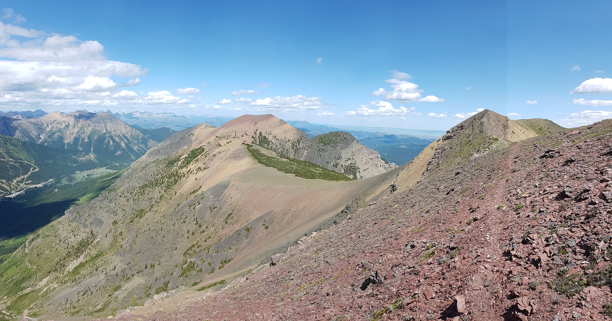
Section A starts on the US-Canadian border and runs north to Highway 3 and the hamlet of Coleman. While Section E is often referred to as part of the trail with wild extremes, Section A is similar in that it starts with maintained and popular trails in a national park but also included what many consider the single hardest day on the GDT.
SECTION A: WATERTON TO CROWSNEST PASS – STARTING THE GREAT DIVIDE TRAIL
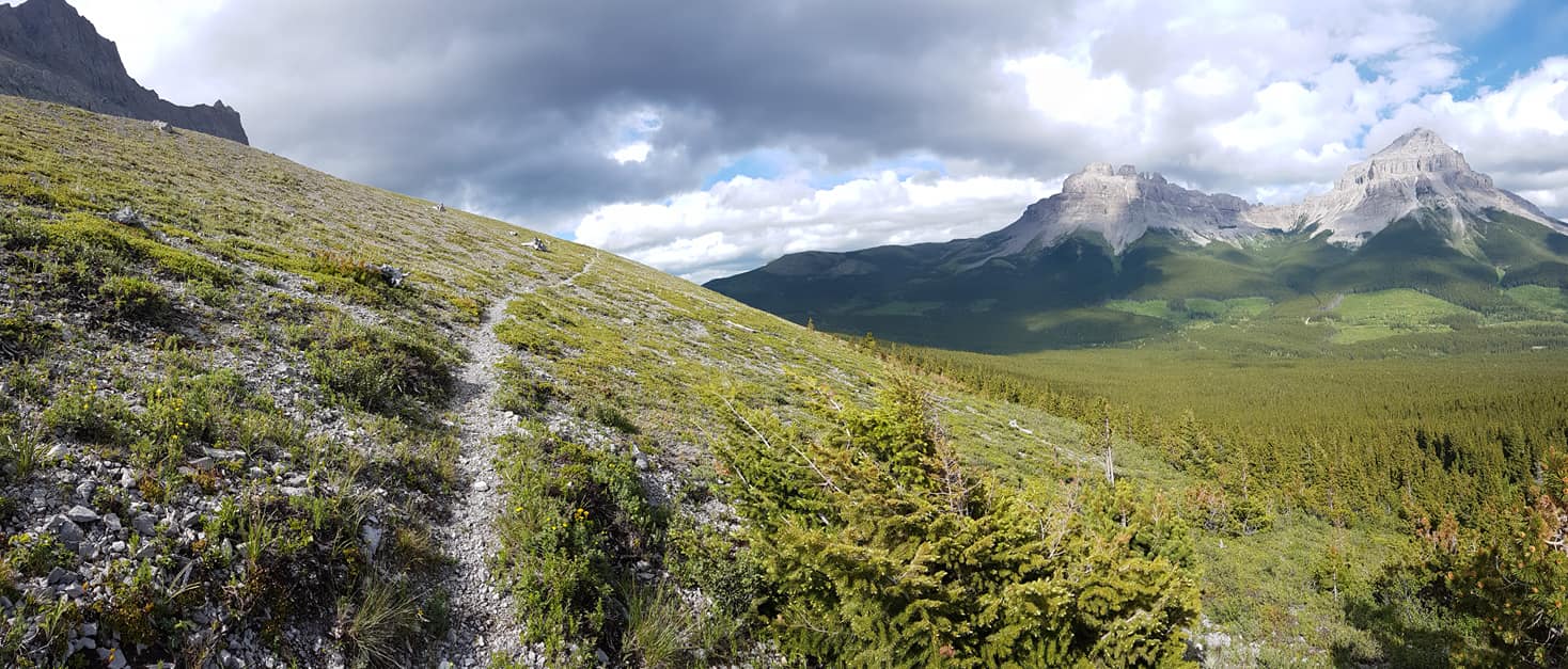
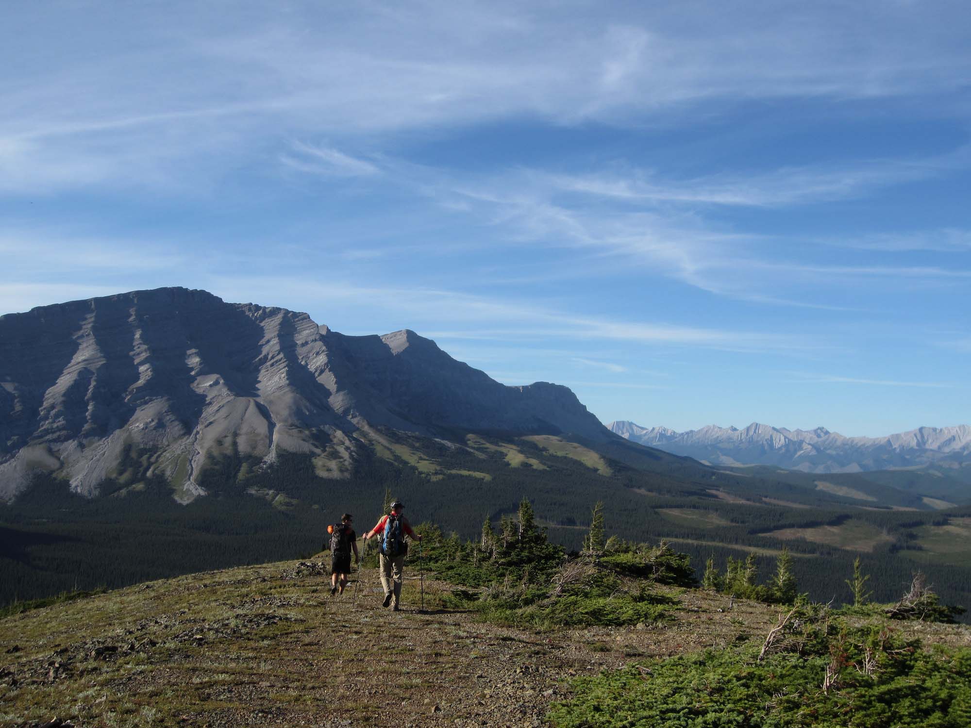
Starting at Boundary Bay on the US-Canadian border where the GDT connects with the Continental Divide Trail in the USA, the GDT heads north through Waterton Lakes National Park in Alberta. In 2017, the Kenow wildfire burned much of the park (thankfully sparing most campgrounds and facilities), but a lot of work has gone into repairing damage and improving things. This does mean you will encounter large burnt sections where there is little shade, and summer days can get hot.
To get to the international border monument marking the start of the trail, most folks will hike from Waterton townsite (and back). It’s only 6 km to the border and can easily be done in a single day. Historically, there has been a boat that takes you to Goat Haunt on the US side where you can hike to the start of the trail. This is an international border crossing and it has been closed for the past few years due to COVID. If/when it re-opens, you will require a passport or suitable ID to cross and will need to check-in with both US and Canadian customs. If you are an international traveller, ensure you can enter the US if you choose this option.
Carthew Lakes in Waterton (photo by Joan Pendleton)
THE GDT THROUGH WATERTON LAKES NATIONAL PARK
Within Waterton Lakes National Park, trails are well maintained and easy to follow. Some portions can be very popular in the summer with day hikers, equestrians, and folks doing a quick overnight. From Boundary Bay, the trail heads north to the Waterton townsite over a few easy mountain spurs. You’re never far from Upper Waterton Lake and water is plentiful. Backcountry campgrounds are available at Bertha Bay and Boundary Bay. The townsite also has full services for lodging, frontcountry camping and resupply.
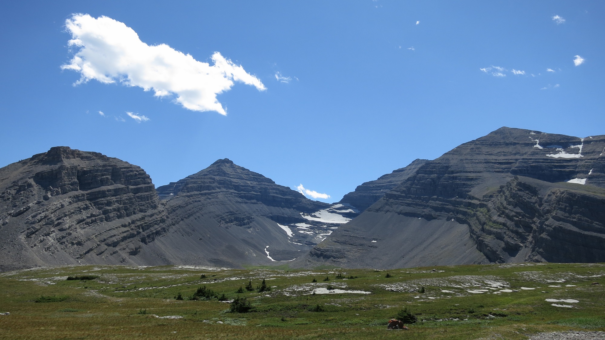
From there it’s up the valley to Carthew Creek, Alderson Lake, and the beautiful Carthew Lakes. The route over Carthew Summit is well marked with wayfinders above treeline. Once over the top, you’ll peer into remote reaches of Glacier National Park in the US and make your way back down to Cameron Lake. Cameron Lake is a busy tourist destination with a small store for refreshments and canoe rentals (last flush toilets for a while). Once you reach Cameron Lake, you’ll have two options. The main route remains in Waterton Lakes NP and follows the popular Tamarack Trail, while the Mount Rowe alternate follows an unmaintained cross-country route on the British Columbia side of the divide. Normally this alternate route is used by folks who are unable to secure permits for the Tamarack Trail or who prefer the option of random camping. Regardless, many will take the option of camping at Akamina Creek on the BC side of the divide as it’s the only place you can camp in this area.
For those following the main route, there is a short section of road walk to the Rowe Lakes trailhead. Through forest, you’ll make your way up to Rowe Meadows (grab water here) and the climb to the second highest point on the GDT, Lineham Ridge. More wayfinders mark the route. Several saddles through the burned Blakiston valley take you past campgrounds at Lone and Twin Lakes and up to Sage Pass where you leave Waterton Lakes National Park.
The Mount Rowe alternate takes you steeply up to the divide on an unmaintained route for 18 km. While shorter, the alternative isn’t a time saver and you’ll be walking a thin line of open terrain between steep cliffs and thick brush. Scenery is spectacular, but not an alternate for bad weather days, or if you’re still earning your trail legs. Load up with water before taking the Mount Rowe alternate as the only water available on route is from melted snow.
Campgrounds in this area:
Boundary Bay – Waterton Lakes National Park (reservation and permit required)
Bertha Bay – Waterton Lakes National Park (reservation and permit required)
Waterton Townsite (Front country) – Waterton Lakes National Park (reservation and permit required)
Alderson Lake – Waterton Lakes National Park (reservation and permit required)
Akamina Creek – Akamina-Kishinena Provincial Park (first come first served)
Lone Lake – Waterton Lakes National Park (reservation and permit required)
Twin Lakes – Waterton Lakes National Park (reservation and permit required)
Entry / Exit Points
South – Waterton Townsite
North – Red Rock Parkway via Twin Lakes / Snowshoe Trail
Resupply
Waterton Townsite
TOWARD THE CASTLE MOUNTAIN SKI RESORT
At Sage Pass, the Mount Rowe alternate and main route converge, leaving Waterton behind and straddling the divide between Castle Wildland Provincial Park in Alberta and forestry land in BC. Random camping is allowed throughout, but there are several rustic campgrounds you can use. The trail here is here is primitive and spectacular, covering several peaks and ridge walks. Quality ranges from “easy to follow” to “route finding”. You’ll encounter what many consider the most difficult day on the entire GDT on La Coulotte Ridge. You’ll want to load up on water at Scarpe Pass (particularly if you’re taking the Barnaby Ridge Alternate) and wait out any inclement weather. Do not underestimate this day.
Barnaby Ridge Alternate (photo by Brad Vaillancourt)
At La Coulotte Peak, the trail splits between the main route and the Barnaby Ridge Alternate. After one more steep climb, the main route drops down into the West Castle River valley along some ATV trails and Highway 774. Barnaby Ridge remains up high and has spectacular scenery, however there is some exposure, and water is limited. It should not be attempted in poor weather. Work has been done to route the trail around the hairiest terrain and flagging has been added. Many will climb down to Grizzly Lake for water and to stay the night. This alternate does bypass the Castle Mountain Ski Resort which can be reached along the main route. Some use the ski resort as a place to mail resupply boxes (call ahead to ensure they are accepting them) and there is a restaurant (check hours), but no store to buy supplies.
Campgrounds in this area:
Sage Pass – BC Forestry (random camping)
Font Creek – Castle Wildland Provincial Park (random camping)
Jutland Creek – Castle Wildland Provincial Park (random camping)
Scarpe Pass – Castle Wildland Provincial Park (random camping)
Grizzly Lake (Barnaby Ridge Alternate) – Castle Wildland Provincial Park (random camping)
Barnaby Lake (Barnaby Ridge Alternate) – Castle Wildland Provincial Park (random camping)
West Castle Road – Castle Wildland Provincial Park (random camping)
South – Red Rock Parkway via Twin Lakes / Snowshoe Trail
North – Alberta Highway 774
Resupply
Castle Mountain Ski Resort (limited)
ON TO COLEMAN
After some initial road walking, the trail moves through an area crisscrossed with old forestry roads, OHV tracks, and seismic lines. The trail can be confusing in parts, and it’s generally not well signed. The terrain itself is not particularly challenging, but you’ll want your maps and GPS to help navigate. At kilometer 129.7, the trail branches with the main route heading to the small hamlet of Coleman on Highway 3. Coleman was a mining boomtown in the first half of the 20th century but doesn’t have a lot of services today. There is a post office to send resupply boxes, motels and Safe Haven BnB is a popular spot for GDT hikers.
The alternate route takes you down a road to the larger town of Blairmore. Here you can find a grocery store, outdoor store, campground, motels and other services for resupply. From Blairmore it’s a 4 km walk to Coleman and the start of Section B.
Campgrounds in this area:
Lynx Creek – Castle Provincial Park (permit required)
Willoughby Ridge – Castle Provincial Park (random camping)
Entry / Exit Points
South – Alberta Highway 774
North – Alberta Highway 3
Resupply
Coleman
Blairmore (off trail)
SECTION B: COLEMAN TO KANANASKIS
Section B of the GDT runs North from the town of Coleman on Crowsnest Highway 3 to Peter Lougheed Provincial Park in Kananaskis, Alberta. This part of the trail runs almost entirely through public land and has little in the way of developed campgrounds or facilities. Except for a small portion in the north, random camping is allowed throughout this section. You may encounter OHV users and, in some cases, active forestry operations along the trail. If you do encounter active logging, keep an eye out and respect any signage.
In some ways, Section B is the birthplace of the GDT. In the 1970s the first portions of dedicated trail were constructed here and work continues to this day with the new High Rock Trail completed in 2021.
ROADS AND OFF HIGHWAY VEHICLE TRAILS
The first part of the trail is largely made up of gravel roads and OHV trails. During the summer (particularly on weekends) you’ll encounter folks camping in their RVs along the Allison Creek and Atlas roads. Parts of this trail can be confusing as there are many junctions connecting a nest of old forestry roads.
Crowsnest Mountain figures prominently to the east as you may your way up the valley. Until recently the trail continued over Deadman Pass into BC, but with parts of the trail crossing private land, the High Rock Trail was built to avoid conflict with industrial users and the Fording River Mine.
Campgrounds in this area:
McGillivray Creek – ATV staging area (Alberta Public Lands Camping Pass required)
Chinook Lake – Alberta Parks (Reservation recommended and permit required)
Atlas Staging Area – ATV staging area (Alberta Public Lands Camping Pass required)
Entry / Exit Points
South – Highway 3
North – Atlas Forestry Road
Resupply
Coleman
Blairmore (off trail)
HIGH ROCK TRAIL
2022 marks the grand opening of the High Rock Trail and the new official route of the GDT. Many will stay at the beautiful Window Mountain Lake for the first night as bear lockers have been recently installed. This section mainly sticks to the Livingstone Public Land Use Zone which allows a wide variety of users. You’ll gain and lose elevation as you move from one drainage to another, first North Racehorse Creek then Dutch Creek. At the headwaters you’ll encounter the old route from the BC side as you climb up to Tornado Pass, through Tornado Saddle and steeply down the other side.
High Rock Trail (photo by Brad Vaillancourt)
Campgrounds in this area:
Window Mountain Lake – Random cCamping (Alberta Public Lands Camping Pass required)
North Racehorse Creek – Random camping (Alberta Public Lands Camping Pass required)
Dutch Creek (HRT) – Random camping (Alberta Public Lands Camping Pass required)
Dutch Creek – Random camping (Alberta Public Lands Camping Pass required)
South Hidden Creek – Random camping (Alberta Public Lands Camping Pass required)
Entry / Exit Points
South – Atlas Forestry Road
North – Alberta Highway 940 (Via Oldman River Road and Hidden Creek Trail)
Resupply
None
BIRTHPLACE OF THE GREAT DIVIDE TRAIL
At North Fork Pass, you’ll join the original GDT and a junction with Dutch Creek Road. This road serves as the first of many access/exit point to Highway 940 on the Alberta side. While this road can be busy in on weekends, it can be fairly quiet on weekdays, so if you have to bail it could be quite a while before you get a hitch. Following the orange blazes, the trail closely parallels the divide with additional access points at Hidden Creek, Cache Creek, Soda Creek, Oldman River, Lost Creek, Cataract Creek, Etherington Creek, and Baril Creek. While you don’t see as many of the epic mountain spires as Section C, the scenery is still spectacular, particularly in and around the Beehive Natural Area. You’ll experience a lot of ups and down in this part with some nice ridge walks. Rustic camping areas are located near many of the creek junctions just mentioned. While the idea of camping on the top of a ridge can be appealing, a sleepless night as your fly flutters in the wind isn’t nearly as much fun as you might think.
Cataract Plateau on the Original GDT (photo by Jocelyn Wood)
At Baril Creek the trail heads to the west and climbs up to Fording River Pass, crossing the Great Divide for the first time since La Coulotte Peak over 130 km to the south.
Campgrounds in this area:
Hidden Creek – Random camping (Alberta Public Lands Camping Pass required)
Cache Creek – Random camping (no permit required)
Soda Creek – Random camping (no permit required)
Lyall Creek – Random camping (no permit required)
Memory Lake – Random camping (no permit required)
High Rock – Random camping (no permit required)
Lost Creek – Random camping (no permit required)
Cataract Creek – Random camping (no permit required)
Etherington Creek – Random camping (no permit required)
James Lake– Random camping (no permit required)
Upper Baril Creek– Random camping (no permit required)
Fording River Pass – Random camping (no permit required)
Entry / Exit Points
South – Alberta Highway 940 (Via Oldman River Road and Hidden Creek Trail)
North – Elk River Road
Resupply
Highwood House (13 km off trail at Baril Creek, limited options)
ELK VALLEY TO PETER LOUGHEED PROVINCIAL PARK
Coming down Aldridge Creek you’ll meet up with the Kananaskis Power Line Road which connects to Elk Lakes Road in about 8 km. This is the longest road walk on the GDT, but it is a lightly trafficked and well-maintained gravel/dirt road. There is a washout on the Aldridge Creek trail and the easiest way past it is to get your feet wet. Elevation gains on this section are minimal, so if you’re looking for a high mileage day, this is it. There are a few user maintained forestry campgrounds along the Elk River Road that offer outhouses and picnic tables.
Fording River Pass (photo by Li Brannfors)
If you’re a confident route-finder, you can avoid some of this road walk by taking the Coral Pass alternate. There is an initial fording of the Elk River, which can be challenging in high water conditions. The pass is incredible and earns its name with plentiful fossilized coral, however, descending the north side involves some exposure, slippery rocks, and can be extremely overgrown. If weather is poor, the recommendation is to stick to the road.
Either way, you’ll soon come to Elk Lakes Provincial Park. From here on in, apart from a small part of Section D, you’ll be on protected lands, leaving OHVs behind for the rest of the trail.
Near the Elk Lakes trailhead, there is a cabin currently operated by the Alpine Club of Canada and a nearby campground. From here there are a few options. First is the Hydroline Trail (popular with mountain bikers), which is a straight shot up to Elk Pass along a set of power lines. There is also Elkan Creek, which takes you through forest to West Elk Pass; it’s shorter, but obscures most of the views. Lastly, there is the official Upper Elk Lake Trail, which offers nice views of the Elk Valley. At Elk Pass you will cross back into Alberta and follow Fox Creek to the trailhead at the end of Section B. There has been talk of installing lockers at the Elk Pass trailhead to allow resupply boxes to be deposited and stored – stay tuned!
Elk Lake Cabin
Coming into Peter Lougheed Provincial Park, random camping is no longer permitted, but there are plenty of options. A full-service campground including showers, store, and ice cream(!!!) are available a few minutes away at Boulton Creek, there is a tent-only campground at Mt. Sarrail, and a third nearby campground at Interlakes. Boulton is popular with thru-hikers as you can book sites with electricity to charge all your devices. It is often booked solid on weekends, but weekdays usually have availability.
The end of Section B is a good place to build a zero day or two into your itinerary. With Section C very dependent on permits and keeping to your schedule, this will give you the flexibility to catch up if you’re running behind, or some time to enjoy the area otherwise.
Campgrounds in this area:
Aldridge Creek – BC Forestry (first come first served)
Weary Creek – BC Forestry (first come first served)
Riverside – BC Forestry (first come first served)
Tobermory Creek – BC Forestry (first come first served)
Lower Elk Lake – Elk Lakes Provincial Park (permit required)
Elk Lakes ACC Hut – Elk Lakes Provincial Park (book through Alpine Club of Canada)
Boulton Creek – Peter Lougheed Provincial Park (reservation recommended and permit required)
Mt. Sarrail – Peter Lougheed Provincial Park (permit required)
Interlakes – Peter Lougheed Provincial Park (permit required)
Entry / Exit Points
South – Elk River Road
North – Alberta Highway 40 – Kananaskis Lake Road
Resupply
Boulton Creek Trading Post (small store with limited supplies)
SECTION C: KANANASKIS TO FIELD
Section C offers some of the most scenic parts of the GDT. Starting at Peter Lougheed Provincial Park in Kananaskis it passes through several national and provincial parks, including the iconic Banff National Park, on its way to the town of Field. Most of this section is well-maintained and signed along official trails. At the same time, you will leave behind some of the seclusion you experienced on earlier sections as you hit several popular backpacking trails.
With the exception of a small portion of trail in Height of the Rockies Provincial Park, camping is only allowed in designated campgrounds and permits are required. As of this posting, national park permits (Banff, Kootenay, Yoho, and Jasper) are available for the 2022 season. If you are considering the GDT for 2022, you’ll want to look into permits as soon as possible as many campgrounds may already be fully booked. For those wanting to section hike the GDT, Section C is a great place to start if you get campground permits.
PETER LOUGHEED AND HEIGHT OF THE ROCKIES
Starting at the Elk Pass trailhead in Peter Lougheed Provincial Park, hike along the shore of Upper Kananaskis Lake to the Upper Lakes trailhead. An alternate route starting from here is Northover Ridge. Rather than hiking counterclockwise toward Interlakes, you’ll hike clockwise along the Upper Lake Trail, splitting off at Hidden Lake and up the headwall to Aster Lake. Here you’ll see the imposing peak of Mount Joffre (also known as The Tooth). This beautiful high alpine valley is well worth it if you have the time. There is a small and popular campground at Aster Lake although random camping is allowed once you cross into BC. Continuing the climb to Northover Ridge, you’ll straddle the divide for 4 km with some mild scrambling and exposure. Off the ridge you’ll descend to Three Isle Lake. There is a popular campground here with lots of peak bagging options. Heading over South Kananaskis Pass, you’ll pass Beatty Lake campground and head steeply down into the Palliser Valley where the route rejoins the main GDT.
Northover Ridge (photo by Barb Lauer)
If you’re sticking to the official GDT route, the trail heads up the upper Kananaskis Valley toward a backcountry campground at Forks. Continuing up the valley you’ll pass Lawson Lake, and a campground at Turbine Canyon, an incredible narrow canyon.
Crossing North Kananaskis Pass, the trail passes back into BC and Height of the Rockies Provincial Park. It descends into the Palliser Valley (random camping is permitted here) where some river fording is required. This part of the trail is infrequently maintained and unsigned. An alternate access point is available by heading south down the Palliser River valley; however, the trailhead is only accessible along a 80 km drive on forestry roads on the BC side.
Campgrounds in this area:
Point (Off trail) – Peter Lougheed Provincial Park (permit and reservation required)
Forks – Peter Lougheed Provincial Park (permit and reservation required)
Turbine Canyon – Peter Lougheed Provincial Park (permit and reservation required)
Aster Lake (Northover Alternate) – Peter Lougheed Provincial Park (permit and reservation required)
Three Isle Lake (Northover and South Kananaskis Pass Alternate) – Peter Lougheed Provincial Park (permit and reservation required)
Beatty Lake (Northover and South Kananaskis Pass Alternate) – Height of the Rockies Provincial Park (first come first served)
Palliser River – Height of the Rockies Provincial Park (no permit required)
Palliser Pass – Height of the Rockies Provincial Park (no permit required)
Entry / Exit Points
South – Alberta Highway 40 – Kananaskis Lake Road
North – Albert River Forestry Road
Resupply
None
ENTER BANFF
On a less-maintained trail, you’ll climb to Palliser Pass and enter the world-famous Banff National Park. This part of Banff is rarely travelled, but there are access/entry points at Burstall Pass and Mount Shark. There are campgrounds in this section at Burstall and Birdwood. Once in Banff NP, random camping is no longer permitted.
After the junction with the Mount Shark Trail, you’ll head up the more popular Bryant Creek Trail. There are backcountry campgrounds at Big Springs, Marvel Lake, and McBride’s Camp. Parks Canada also operates a shelter at Bryant Creek. Its a fairly basic cabin with a stove, common eating area, and shared sleeping platforms. The cabin is currently closed for reconstruction. Permits are required to stay at any of these locations.
Marvel Lake (photo by Li Brannfors)
The main GDT heads down Marvel Lake and over the high Wonder Pass where the scenery is incredible. The Allenby alternate provides a less exposed route into Mount Assiniboine Provincial Park.
Campgrounds in this area:
Burstall – Banff National Park (permit and reservation required)
Birdwood – Banff National Park (permit and reservation required)
Big Springs – Banff National Park (permit and reservation required)
Marvel Lake – Banff National Park (permit and reservation required)
Bryant Creek Cabin (Closed) – Banff National Park (permit and reservation required)
McBrides Camp (Allenby Alternate) – Banff National Park (permit and reservation required)
Allenby Junction (Allenby Alternate) – Banff National Park (permit and reservation required)
Entry / Exit Points
South – Albert River Forestry Road
Mid – Highway 742 – Mt Shark Trailhead via Bryant Creek Trail
North – Allenby Pass Trail
Resupply
None
MOUNT ASSINIBOINE AND SUNSHINE MEADOWS
At Wonder Pass you enter Mount Assiniboine Provincial Park, often called the Matterhorn of North America. Assiniboine has been a popular backcountry destination since the Canadian Pacific Railway was built. Several campgrounds and huts are available, and for those with deep pockets, the Assiniboine Mountain Lodge. Tea is available to the public between 4 and 5 pm (this may be affected by COVID). This portion of the trail can be extremely busy and resupply is available via helicopter. From the campgrounds at Lake Magog and Lake Og the trail heads through the Valley of the Rocks, up to Citadel Pass, and back into Banff National Park. Since it can be hard to reserve spots at Magog and Og, some will stay at the Porcupine campground (700m off trail). It’s a pleasant hike through alpine and subalpine meadows past Howard Douglas lake and Quartz Hill, to the Sunshine Ski Resort. During the summer there is a restaurant and hiker gondola that will take you down to the main parking lot (this may be affected by COVID). Shuttle buses or taxis are available here to the Banff townsite and Lake Louise, both of which are extremely busy in the summer. Some will use this as an opportunity to exit the trail to experience the town of Banff.
Mount Assiniboine and Lake Magog (photo by Li Brannfors)
From Sunshine, the trail passes over Simpson and Healy passes (George Simpson was a colonial governor for the Hudson’s Bay Company who circumnavigated the world by land in 1841). The Healy Creek alternate also provides access to the Sunshine parking lot. Descending into the popular Egypt Lakes area, there are several trails, campgrounds, and shelters operated by Parks Canada. Expect this section of the trail to be busy. Leaving the crowds behind, the GDT passes over the rarely used Ball Pass into British Columbia and Kootenay National Park, down the Hawk Creek Trail to reach Highway 93. This is the single largest descent on the trail at just over 1000m (SOBOs beware)
Campgrounds in this area:
Lake Magog – Mount Assiniboine Provincial Park (permit and reservation required)
Naiset Huts – Mount Assiniboine Provincial Park (reservation required, booked via Assiniboine Lodge)
Assiniboine Lodge – Mount Assiniboine Provincial Park (reservation required)
Og Lake – Mount Assiniboine Provincial Park (permit and reservation required)
Porcupine – Mount Assiniboine Provincial Park (first come first served)
Howard Douglas Lake – Banff National Park (permit and reservation required)
Healy Creek (off trail) – Banff National Park (permit and reservation required)
Egypt Lake – Banff National Park (permit and reservation required)
Egypt Lake Cabin (Closed) – Banff National Park (permit and reservation required)
Ball Pass Junction – Banff National Park (permit and reservation required)
Entry / Exit Points
South – Highway 742 – Mt Shark Trailhead via Bryant Creek Trail
Mid – Sunshine Ski Resort
North – Highway 93S – Hawk Creek Trailhead
Resupply
Assiniboine Lodge (pre-arranged via helicopter)
Sunshine Ski Resort (might not be available in 2022 due to Covid)
THE ROCKWALL
Next up is the popular Rockwall Trail. Climbing up to Floe Lake, you’ll find the single most popular campground on the GDT, getting a spot here is like trying to get tickets to the Rolling Stones. Each year the campground is fully booked within minutes of it opening for reservations. The trail crosses several watersheds at Numa Creek, Tumbling Creek, and Helmet Creek. Each of these has both a campground (permit required) and acts as an entry/exit point. There are several good views of Helmet Falls, the second-highest waterfall in the Canadian Rockies. Leaving behind the Kootenays, the trail heads through Goodsir Pass, into Yoho National Park, and after a short walk along the TransCanada highway, reaches the town of Field.
Floe Lake on the Rockwall Trail (photo by Jenny Feick)
Campgrounds in this area:
Floe Lake – Kootenay National Park (permit and reservation required)
Numa Creek – Kootenay National Park (permit and reservation required)
Wolverine Pass – BC Forestry random camping (no permit required)
Tumbling Creek – Kootenay National Park (permit and reservation required)
Helmet Falls – Kootenay National Park (permit and reservation required)
McArthur Creek – Yoho National Park (permit and reservation required)
While Section D is the shortest, it has been called the most difficult part of the GDT. For the most part you’ll be on unofficial and unmaintained trails where blowdowns, overgrown trail and washouts can be common. Creek crossings are largely unbridged, so be prepared to ford rivers and streams. Some hikers have mentioned not encountering another person while hiking this part of the trail and this wilderness solitude is part of the charm of Section D. Starting at the hamlet of Field in Yoho National Park, Section D finishes up at a major highway junction and resort at Saskatchewan Crossing on the Icefields Parkway (Highway 93).
Near Burgess Pass on the Kiwetinok Alternate (photo by Brad Vaillancourt)
LEAVING FIELD
Field started out as a major switching point for the Canadian Pacific Railway. Prior to the construction of the spiral tunnels in 1909, the descent from Kicking Horse Pass was the location of the “Big Hill”. This extremely steep section of track required large steam locomotives to be added to trains to help them up the grade. Field was the center of these operations, but today, with a population of less than 200, it’s mainly a place for tourists, hikers, and campers. There are several B&B options to stay at within Field as well as two nearby frontcountry campgrounds at Kicking Horse and Monarch.
From Field, the main GDT follows the Amiskwi Valley towards Amiskwi Pass. While the first part of this trail is maintained, if fairly quickly falls into disuse and blowdowns are frequent. You’ll have to ford the Amiskwi River 3 times as you make your way up the valley. Random camping is permitted once you’re 4 km away from the trailhead, however a random camping permit is still required from Parks Canada.
An alternate route takes you steeply up to the Burgess Highline Trail, Yoho Lake campground, and onto the popular Iceline Trail. The views of Takakkaw Falls and Waputik Icefield across the valley are incredible. A campground and Alpine Club of Canada cabin are located in the Little Yoho Valley. From the campground however, you’ll climb steeply up to Kiwetinok Pass where the trail ends and 8 km of cross-country route finding begins.
Campgrounds in this area:
Kicking Horse (Frontcountry off trail) – Yoho National Park (permit and reservation required)
Monarch (Frontcountry off trail) – Yoho National Park (permit and reservation required)
Takakkaw Falls (Frontcountry off trail) – Yoho National Park (First come first served and permit required)
Yoho Lake (Kiwetinok alternate) – Yoho National Park (permit and reservation required)
Little Yoho (Kiwetinok alternate) – Yoho National Park (permit and reservation required)
Stanley Mitchell Hut (Kiwetinok alternate) – Alpine Club of Canada (reservation required)
Amiskwi River – Yoho National Park random camping (permit required)
Entry / Exit Points
South – Trans-Canada Highway 1
North – Blaeberry Forestry Road
Resupply
Field
WALKING THE EXPLORER’S ROUTE
Over Amiskwi Pass you’ll enter the Blaeberry River valley. Leaving behind Yoho National Park, this will be the first time you’ll have been outside of a park since entering Elk Lakes Provincial Park in Section B. Much of the trail on this side of the pass is on forestry roads until you start on the David Thompson Heritage Trail. Named after the consummate explorer, David Thompson hiked or horsebacked over 90,000 km during the early 19th century, mapping over 4.9 million square km of North America. This historical route was used by the Secwépemc people as a travel and trade route, connecting Secwépemc ancestors to the northern Stoney and to the Rocky Mountain House during the fur trade.
Much of the road walking can be bypassed by taking a new shortcut along Collie Creek, it does however require a potentially dangerous ford so be open to adjusting your route. Early morning crossings are recommended. Much work is being done to improve the Collie Creek Trail with the goal of making it the main route. The GDT can also be exited here down the Blaeberry River road to the Trans-Canada Highway near the town of Golden.
Howse Pass
Campgrounds in this area:
Amiskwi Pass – Random camping (no permit required outside of the national park)
Cairnes Creek – Random camping (no permit required)
Lambe Creek – Random camping (no permit required)
Entry / Exit Points
Blaeberry Forestry Road
Resupply
None
HOWSE PASS
Back to the Blaeberry, you’ll climb to the seldom used Howse Pass where the trail crosses the Great Divide below the treeline, back into Banff National Park in Alberta. Today the GDT mainly follows the Howse River floodplain as the former trail is choked with hundreds of blowdowns. Prepare for wet feet on this part of the trail as the route fords the many side channels of the floodplain. After the junction with the Glacier Lake Trail (recommended only for equestrians due to the deep ford of the Howse River), you’ll rejoin good trail and head towards Saskatchewan Crossing by following the trail to the Mistaya Canyon trailhead on the Icefields Parkway (Highway 93).
Howse River floodplain (photo by Brad Vaillancourt)
At Saskatchewan Crossing you’ll find a hotel, restaurant, gas station, and well equipped (if expensive) general store. If you plan to stay here, you’ll want to book ahead.
Campgrounds in this area:
Conway Creek – Banff National Park (random camping permit required)
Howse Floodplain – Banff National Park (random camping permit required)
Howse River – Banff National Park (random camping permit required)
Entry / Exit Points
South – Blaeberry Forestry Road
North – Highway 93N (Icefields Parkway)
Resupply
Saskatchewan Crossing Resort
SECTION E: SASKATCHEWAN CROSSING TO JASPER
“It was the best of times, it was the worst of times”. Section E on the Great Divide Trail is a study in contrasts. The stretch between Saskatchewan Crossing and the town of Jasper passes through remote areas of White Goat Wilderness Area and the decommissioned trails of the Maligne Valley. At the same time it also passes through the extremely popular Skyline Trail and Jonas Shoulder sections of Jasper National Park. However, if you love hiking above the treeline, this is the section for you.
OWEN CREEK
Leaving the resort at Saskatchewan Crossing, there is a short section of road walking along the David Thompson Highway. From the Owen Creek trailhead you’ll start your climb. The trail here is unmaintained and can be hard to follow. The creek quickly turns into a canyon as you struggle your way up to Owen Pass and treeline. For the next 18 km you’ll parallel a stunning rock wall through the alpine and pass by Michele Lakes, the prettiest lakes on the GDT, to reach the highest point on the GDT at 2585m.
Michele Lakes (photo by Charlene Deck)
Campgrounds in this area:
Owen Creek – Banff National Park (random camping permit required)
Michele Lakes – Random camping (Alberta Public Lands Camping Pass required)
Waterfalls Creek – Random camping (Alberta Public Lands Camping Pass required)
Pinto Creek – Random camping (Alberta Public Lands Camping Pass required)
Pinto Lake East – Random camping (Alberta Public Lands Camping Pass required)
Pinto Lake North – Random camping (Alberta Public Lands Camping Pass required)
Cataract Creek – White Goat Wilderness Area random camping (no permit required)
Cataract Pass – White Goat Wilderness Area random camping (no permit required)
Entry / Exit Points
South – Highway 11
North – Highway 11 via Waterfalls trail
Resupply
None
HEIGHT OF THE CANADIAN ROCKIES
One thing that surprises a lot of people who have seen the towering peaks of the Canadian Rockies, is their height when compared to the Colorado Rockies or Sierra Nevada mountains. There are no 14ers (4267m) in Alberta or eastern BC, with the highest mountain in the range being Mount Robson at 3954m (12,972 ft). What makes the Canadian Rockies different is during the last ice age, glaciers carved out the valleys making the mountains much more prominent. The northern latitude and shorter glowing season also pushes down the treeline, making it 450-750m lower than Colorado. Combined, these makes it seem like the mountains are much higher. On the plus side, this reduces the risk of altitude acclimatization as you’ll never be over 2590m (8,500 ft).
UP TO CATARACT PASS
Heading over 3 mountain passes, the trail drops back into the trees around Pinto Lake. You can exit the trail here by way of Sunset Pass which takes you back to the highway. The thru route takes you into the White Goat Wilderness Area where trail maintenance is not allowed (hence the many fallen trees). The route travels up the long Cataract Creek valley to lofty Cataract Pass on the border of Jasper National Park. Along the way you’ll have a chance to see ancient pictographs. Over Nigel Pass the GDT joins the well maintained (and more crowded) trails of the Brazeau Loop. Back into the alpine, the Jonas Shoulder offers spectacular views of the valley, however as the trail heads north, it becomes less travelled and once you pass the Poboktan Creek junction (another exit to the highway), it is no longer maintained.
Cataract Pass (photo by Li Brannfors)
Campgrounds in this area:
Boulder Creek – Jasper National Park (permit and reservation required)
Four Point – Jasper National Park (permit and reservation required)
Cline (off route) – Jasper National Park (permit and reservation required)
Jonas Cutoff – Jasper National Park (permit and reservation required)
McCready Horse Camp – Jasper National Park (permit and reservation required)
Waterfalls – Jasper National Park (permit and reservation required)
Poboktan – Jasper National Park (permit and reservation required)
Entry / Exit Points
South – Highway 11 via Waterfalls trail
Mid – Highway 93N via Sunset Pass trail
Mid – Highway 93N via Nigel Pass trail
North – Highway 93N via Poboktan Trail
Resupply
None
MALIGNE VALLEY
Reaching Maligne Pass, the GDT heads down the valley into forest and several un-bridged creek crossings. Folks have reported that this section of trail has started to deteriorate with GDT hikers being the only ones to really use it. As the Maligne Pass Trail passes through sensitive caribou and grizzly bear habitat, Parks Canada limits access to two parties per day. It’s important to adhere to these restrictions and have the appropriate permits to ensure this section of trail remains open to hikers. Note the popular Six-Passes alternate route is closed in 2022 due to similar concerns of overuse in sensitive habitat areas.
Maligne Pass
Campgrounds in this area:
Mary Vaux – Jasper National Park (permit and reservation required)
Mary Schaffer – Jasper National Park (permit and reservation required)
Trapper Creek (closed in 2022) – Jasper National Park (permit and reservation required)
Entry / Exit Points
South – Highway 93N via Poboktan Trail
North – Maligne Lake
Resupply
None
ENTER THE SKYLINE
The path brings you to the popular tourist area of Maligne Lake. Shuttles are available here to Jasper, there is a small gift shop, a lake tour and café. Maligne Lake is also the start of the extremely popular Skyline Trail. Spending most of its time in the alpine, people from around the world come to Jasper just to hike Skyline. Permits can be hard to get, so some GDTers will hike the 40+km in a single day, or divert to Watchtower campground which is a bit off trail. A few popular tourist trails lead you from the end of Skyline and into the town of Jasper and the end of Section E.
Skyline Trail (photo by Erin Saver)
Campgrounds in this area:
Evelyn Creek – Jasper National Park (permit and reservation required)
Little Shovel – Jasper National Park (permit and reservation required)
Snowbowl – Jasper National Park (permit and reservation required)
Watchtower (Off Trail) – Jasper National Park (permit and reservation required)
Curator – Parks Canada – Jasper National Park (permit and reservation required)
Tekarra – Jasper National Park (permit and reservation required)
Signal Mountain – Jasper National Park (permit and reservation required)
Entry / Exit Points
South – Maligne Lake
North – Jasper
Resupply
Jasper
SECTION F: JASPER TO MOUNT ROBSON
It is here where the GDT really starts to become remote. The route heads north from the more travelled sections of Jasper and deep into the hinterlands. Before attempting this section, ensure you’re comfortable with off trail navigation and being self-sufficient. It’s not uncommon to go several days without seeing anyone. On the flip side, by many accounts, this is among the most sublime sections of the GDT.
Moose River (photo by Erin Saver)
LEAVING JASPER TOWNSITE
Heading west from the town of Jasper, lies the Yellowhead highway. It’s named after Pierre Hastination, a 19th century Iroquois trapper and fur trader known for his blonde hair, earning him the nickname Tete Jaune (or Yellow Head). This is probably the most significant portion of road walking on the trail as the highway can be busy. Some will try to skip this walk and hitch the 20 km to the Miette River trailhead. Alternatively, you can avoid the highway by following a network of trails, old tote roads, and a bit bushwhacking to make it to the same trailhead. Chasing the Miette River up to its source, you’ll climb over Centre, Grant and Colonel Passes before climbing down into the adjacent Moose River valley in Mount Robson Provincial Park. A long alternate here follows the Moose River back down to Highway 16. You’ll ford the river several times as you head up the valley towards Moose Pass at its head.
Campgrounds in this area:
Minnow Lake (Marjorie-Dorothy Lakes alternate) – Parks Canada (Permits and reservations required)
Miette River – Parks Canada random camping (Permits required)
Miette Lake – Parks Canada random camping (Permits required)
Colonel Pass – Parks Canada random camping (Permits required)
Trio (Moose River alternate) – BC Parks random camping (No permit required)
Colonel Creek– BC Parks random camping (No permit required)
Steppe Creek – BC Parks random camping (No permit required)
Slide – BC Parks random camping (No permit required)
Calumet – Parks Canada random camping (Permits required)
Entry / Exit Points
South – Highway 16
Mid – Highway 16 via Moose River alternate
North – Highway 16 via Berg Lake alternate
Resupply
Jasper
MOUNT ROBSON AND BERG LAKE
At Smoky River you’ll encounter a key decision point. This is the junction with the world-famous Berg Lake Trail. The route through Mount Robson Provincial Park was the original terminus of the GDT and many still exit here. It’s much easier to access the trailhead from here compared to the current terminus at Kakwa Lake. Others will use Mt. Robson as a resupply point. It is however, a 30-mile (50km) round trip and permits to camp along the Berg Lake trail can be difficult to obtain. The trail passes by Mt Robson, the tallest mountain in the Canadian Rockies (just shy of 13,000 ft) which drops its ice in the aptly named Berg Lake. Note: Due to flooding in 2021, the Berg Lake trail is currently closed with no details if it will be open in 2022.
Mount Robson (photo by Li Brannfors)
Campgrounds in this area:
Adolphus (off trail) – Parks Canada (Permits and reservations required)
Robson Pass (Berg Lake alternate) – BC Parks (Permits and reservations required)
Rearguard (Berg Lake alternate) – BC Parks (Permits and reservations required)
Berg Lake (Berg Lake alternate) – BC Parks (Permits and reservations required)
Marmot (Berg Lake alternate) – BC Parks (Permits and reservations required)
Emperor Falls (Berg Lake alternate) – BC Parks (Permits and reservations required)
Whitehorn (Berg Lake alternate) – BC Parks (Permits and reservations required)
Kinney Lake (Berg Lake alternate) – BC Parks (Permits and reservations required)
Entry / Exit Points
Highway 16 via Berg Lake Trail
Resupply
Mount Robson
SECTION G: MOUNT ROBSON TO KAKWA
Several sections of the trail vie for the moniker “heart of the GDT”. Section B contains the first dedicated sections of trail (and where a lot of current work is being done). Section C passes through some of the most spectacular scenery in the Rockies, but it is also the most popular and crowded. Parts of Section E spend mile after wondrous mile in the high alpine. However, it is Section G where you truly encounter the rugged, remote wilderness that the GDT is known for. Once you leave highway 16 past the Jasper townsite, you won’t cross another road until you finish the trail. Here trails are rarely maintained, bridge crossings are few, deadfall is plentiful and bail out options are limited, but you will be rewarded by some of the most spectacular hiking on the Great Divide. Be prepared for up to 10-day (or longer) food carries.
THE NORTH BOUNDARY TRAIL
Continuing on the main route of the GDT, we move from section G to section F and the remote (and soggy) Smoky River valley. At Chown Creek and Bess Pass you’ll be following parts of the Jasper North Boundary Trail. This can be hiked as a separate 115 mile (185 km) thru-hike taking you through the remote northern sections of Japer National Park. From this point on, you may encounter horses on the trail so make sure to brush up on your etiquette.
Jackpine River (photo by Erin Saver)
Leaving the North Boundary Trail you’ll cross into the Jackpine Valley and the first of several similar decisions you’ll make from here on in. At many points the trail will splits between a high route and a low route. The high routes typically take you above the treeline, giving you incredible views of remote peaks, glaciers and valleys. On the flip side, these high routes are exposed to lightning, and often involve route finding (no trails). If conditions are good, most folks recommend taking the high routes. If weather is poor, you may have to constrain yourselves to the muddier, brushier valleys.
Campgrounds in this area:
Wolverine North (often flooded into late August) – Parks Canada (Permits and reservations required)
Timothy Slides – Parks Canada random camping (Permits required)
Chown Creek – Parks Canada (Permits and reservations required)
Entry / Exit Points
South – Highway 16 via Berg Lake Trail
North – Highway 16 via Holmes River Road and Blueberry Lake (Jackpine Highroute)
Resupply
Some folks will make arrangements for supplies to be cached at Blueberry Lake
TAKING THE HIGH OR LOW ROAD
For the Jackpine, the main trail takes you across a ridge line with a lower alternate trail in the valley. Work is being done to clear the trail in this area, do remember to thank a volunteer if you come across a crew. You can exit the trail at Holmes River, but this is a 25 mile (43km) unmaintained route back to highway 16. At Jackpine Mountain, you can again choose to stay in the alpine along the Perseverance and Loren Lake High Routes or climb down to the Jackpine River.
Jackpine Pass (photo by Barb Lauer)
The trails rejoin each other at Big Shale Hill and closely parallel the Great Divide for several miles with an optional side trip to the summit of Mount Talbot. Staying up high, the trail heads over Morkill and Fetherstonhaugh Passes.
Back down into Casket Creek valley, you’ll find a junction with the Sheep River trail and an exit to Grande Cache in Alberta. This 45 mile (72 km) unmaintained trail through the Wilmore Wilderness, has a few significant fords, but ends in town and full services.
Passing into BC and Kakwa Provincial Park, the next two alternates are the Surprise Pass and Providence Pass high routes. If conditions allow, again, taking these high routes are preferred as you can enjoy beautiful views of Cecilia Lake. The two trails meet up again at Kakwa Lake and the official end of the trail. A campground and cabin mark the terminus of the GDT.
Kakwa Lake and cabin (photo by Erin Saver)
Campgrounds in this area:
Jackpine River – Random Camping (Alberta crown land camping pass required)
Pauline Creek – Random Camping (Alberta crown land camping pass required)
Shale Pass – Random Camping (no permits required)
Morkill Pass – Random Camping (no permits required)
Casket Pass – Random Camping (Alberta crown land camping pass required)
Copper Kettle – Random Camping (Alberta crown land camping pass required)
Broadview Lake – BC Parks Random camping (no permits required)
Kakwa Lake – BC Parks Random camping (no permits required)
Kakwa Lake Cabin – BC Parks (first come first served)
Entry / Exit Points
South – Highway 16 via Holmes River Road and Blueberry Lake (Jackpine Highroute)
Mid – Grande Cache (Alberta Highway 40) via Sheep River Trail
North – None
Resupply
None
NOT QUITE DONE YET
This isn’t the end though. Several bridge washouts on the Kakwa Lake road currently makes the terminus inaccessible by vehicle. From the lake it’s a 30km walk to the Bastille Creek Trailhead which is the closest you can get by vehicle (and on a rough forestry road at that). Down the road, it’s 74 km (46 miles) to highway 16. While some have managed to grab a hitch along the forestry road, others have had to walk all the way to the main highway. From there you’ll need to get a ride west Prince George (the closest Airport to the terminus) or east towards Valemont and Jasper. There is talk of BC Forestry making repairs to this road, so stay tuned for updates.
Campgrounds in this area:
Buchannan Creek (hike out) – Random camping (no permits required)
Entry / Exit Points
South – None
North – Highway 16
Resupply
You’re still here? It’s over, go home ? either that or turn around and start back south…
This is how this trip was advertised by Dan: “Do you love the GDT, hard work, and short notice trips? Next weekend (August 14/15) a group of GDTA volunteers are flying in to the remote Jackpine Valley in Section G for a week of hard work and suffering. We may have a few extra spots in the heli. The Jackpine Valley is the roughest stretch on the entire GDT, as it hasn’t been maintained for decades. This fly-in trip with brush saws will make a huge difference for future hikers. We’re getting dropped off deep in the woods and then backpacking out 5 0km over the next 7 days. Expect long days of hard work and slow progress.”
Recruitment Poster courtesy of Tara Frey-Durston and Dan Durston
So of COURSE we went on this trip! Just to top it off it rained for a good part of the week too. Please enjoy this video showing a bit of what we did during this amazing week. It was so much work but so much fun and in the most beautiful part of paradise. Top it all off with some crazy hard workers and good times! Best part is… there is still another half of the valley to clear!
Looking for inspiration for your summer on the trails? Check out these amazing videos created by three talented thru-hikers from the GDT class of 2021.
Brigid Scott
Brigid is a teacher and outdoor adventurer from Jasper, AB, with a scrambling and photography problem. Follow along for daily videos of her 2021 thru-hike with her husband, Mark:
Justin is an outdoorsman from Calgary, AB, lucky enough to be in one of the best places to get out and experience the backcountry and outdoors. His YouTube channel is all about taking you on those journeys and providing some tips, tricks, and gear recommendations for your own adventures. Take a look at the video of his solo GDT thru-hike:
After a challenging and rewarding 30 years as a police officer, Bruce retired healthy, happy, and ready for new challenges. He thru-hiked the Bruce Trail in 2019, the Rideau Trail for the second time in 2020, and the GDT in 2021. When he’s not backpacking, Bruce can be found paddling, cycling, or circling the continent in an RV with his wife of 38 years. Below is a link to his GDT trail diaries:
The Cairnes Creek crossing has presented a problem in recent years with washouts due to high levels of glacial runoff and flood waters. Our goal last year was to re-establish a safe means of crossing at the David Thompson Trail junction. Dave Higgins led a team in June that prepped the site and made a valiant effort to move a 15m tree into position but fell short as some of our equipment couldn’t bear the load. Our group of eight was not to be deterred and built a temporary structure that enabled hikers a crossing for the 2021 hiking season. A day trip to the Lambe Creek crossing involved some trail work to bypass some wet sections as well as railing repairs at the Lambe Creek Bridge.
A group of four returned in September with some heavy duty gear and a new plan. The new structure progressed without a hitch and we are left with an elevated crossing that should last for years!
These efforts were captured on video for you to enjoy as you watch the bridge building action.