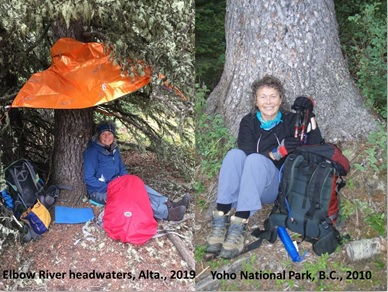
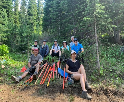
Another summer, another section of the GDT completed. Woohoo! This summer it was Section D, Saskatchewan Crossing to Field (SOBO). Lynnie and I have now completed more than half of the GDT and feeling better and better that we will eventually complete it all!
Section D SOBO with the various alternates might just be my new favourite section… the variety of the terrain (floodplain, ridge walk, historical pass, spectacular pass, moraines, and glaciers – it had it all), the relatively easy start (it’s very flat if you start at Saskatchewan Crossing!), the new trail and bridges that have been built, the co-operating weather when we needed it most and the remoteness (we saw only two other hikers on the main part of section D – excluding the popular Iceline and Mistaya Canyon).
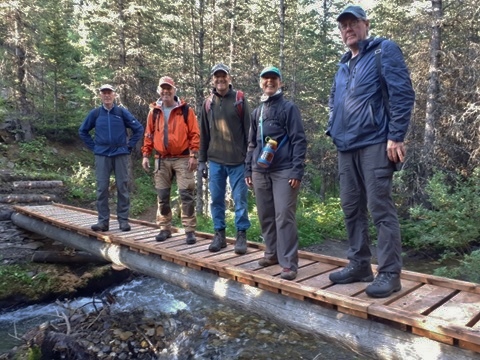
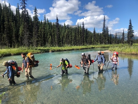
We completed Section D (~115km) in 6 days, 5 nights starting on August 21 and were joined by Dustin Lynx, author of Hiking Canada’s Great Divide Trail and River Taig, an uber experienced thru-hiker having hiked the GDT almost four times! In addition to the wonderful company, it is always nice to have along very strong hikers who can go first on the water crossings! Neither River nor Dustin had hiked the newly created route for Section D with the spectacular alternate routes. And we were all especially excited to celebrate River’s six-month post kidney donation anniversary on the hike! WOW! It was both humbling for us and exciting to celebrate with River!!!
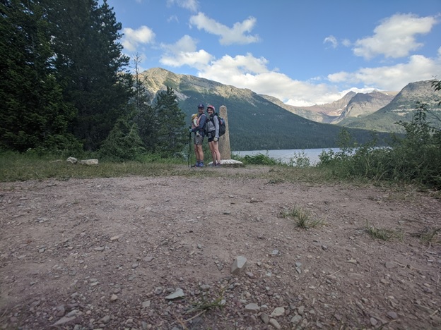
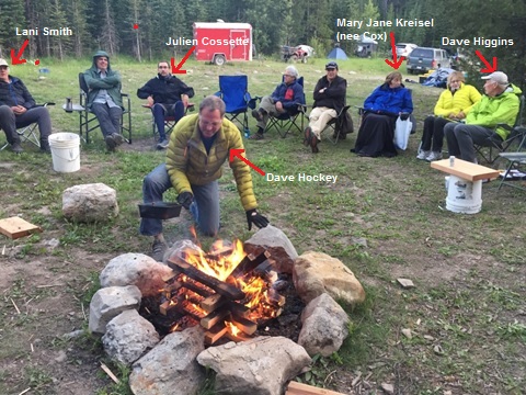
The Team (still smiling at the end; left to right: River, Lynnie, Barb and Dustin)
Based on Dustin and River’s stories of the previous Section D, a HUGE shout out to Dan Durston, and Brad Vallancourt who created the new route including alternates, and to Dave Higgins and Doug Borthwick who have led trail building crews to Section D for the past few summers. Thank you!!
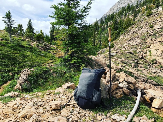
We started out in sunshine from Owen Creek (this is where Section E starts) and walked a lovely trail that was out of sight of the David Thompson highway and had great views of Mount Murchison. At the intersection with Hwy 93 we turned left and walked along this highway for about 5 km to Mistaya Canyon trailhead. It was on this highway that we met one of our thru-hiker icons for the trip, a solo hiker named Annie – a positive, strong looking 20 something year old who looked like she was on a day hike! She came into our minds a few times on the trip “wow, how did she do this on her own?” We met two other thru-hikers… more on them later.
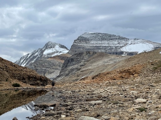
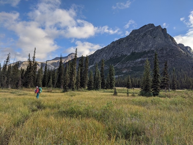
We continued from Mistaya Canyon and joined the Howse Floodplain – they are both spectacular! With the sun still shining, we kept walking and eventually found a place to random camp.
Howse FloodplainMore Howse Floodplain
We were a bit surprised how often the main route along the floodplain did go into the forest. But the tradeoff of not having to continually cross water, appealed to most of us. River was the exception and was itching to get back out to the floodplain where there isn’t always a trail to follow, it can be faster, and the views are much better. Either way, there were also a few very steep, a bit sketchy up and down climbs to avoid dangerous crossings of the Howse River. The route also crosses Conway Creek, which would have been a lot scarier if Dustin and River weren’t there to lead the way. The other thing to watch for along the floodplain is crossing innocuous looking streams, slow moving water clouded with slit so you can’t see the bottom… they can get quite deep without much warning! So I’ve added to my water crossing learnings… pole ahead to test the depth of water!
We met our next iconic happy thru-hiker on the way to Howse Pass. He was walking barefoot and had lovely painted toenails!! Apparently, he started out with sandals but they were hurting his feet and so he reverted to no shoes as much as possible! How he did this with all the rocks, tree roots, pine needles, wood splinters, you get the picture, I have no idea.
Walking through the historic Howse Pass with the plaques and historic signage felt really special.
One of the signs at Howse Pass
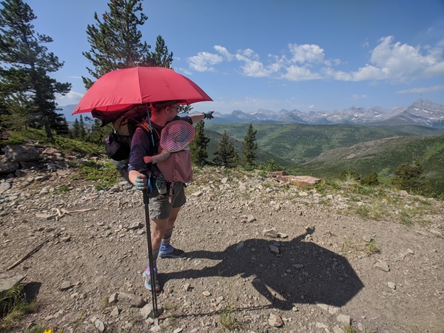
We camped at Lambe Creek after a day of on again off again rain – we were soaked. No rain gear seems to prevent wetting out after hours in the rain…. that is except my bright blue poncho (picture below which nobody else would be caught dead walking in!).
It was at Lambe Creek that we met our third iconic happy hiker – Justin Outdoors. After a day of rain, he walked into camp smiling! I had to ask him if he was dry, i.e. why are you so happy?? As it turns out he was soaked as well. And I can only think that he was relieved to be camping with four wet, tired, mildly grumpy old folks on the trail. Sometimes any company is good company! Word quickly spread through our camp that Justin is a You Tuber with many thousands of followers…. check out his videos of his GDT hike this summer.
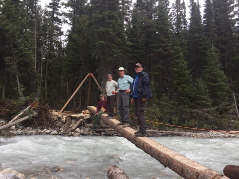
Just by Lambe Creek campsite, there is bridge over Lambe Creek which was repaired this summer by the GDTA. Lynnie volunteered on this maintenance trip … she shared some harrowing stories of folks leaning off the bridge (while properly secured) to reinforce the railing. Much harder work than thru-hiking the trail. Thank you GDTA volunteers!!!
The bridge over Lambe Creek (phew!)Another new bridge, this one over Cairnes Creek
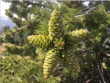
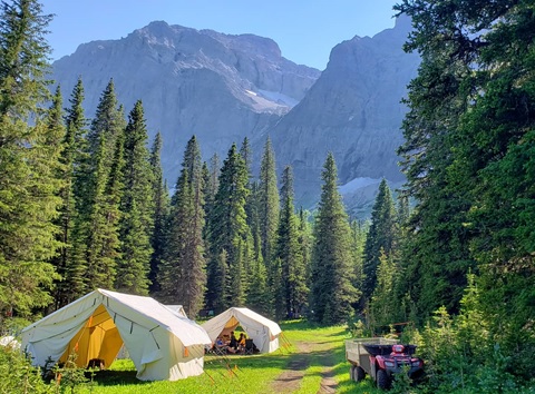
We had a very short day after Lambe Creek (~7 km) and camped at Cairnes Creek, as we chose to wait out the weather. We were aiming for no rain, snow, or heavy cloud cover when we tackled Amiskwi Ridge. A hard core thru-hiker could definitely do Section D in less time than we did.
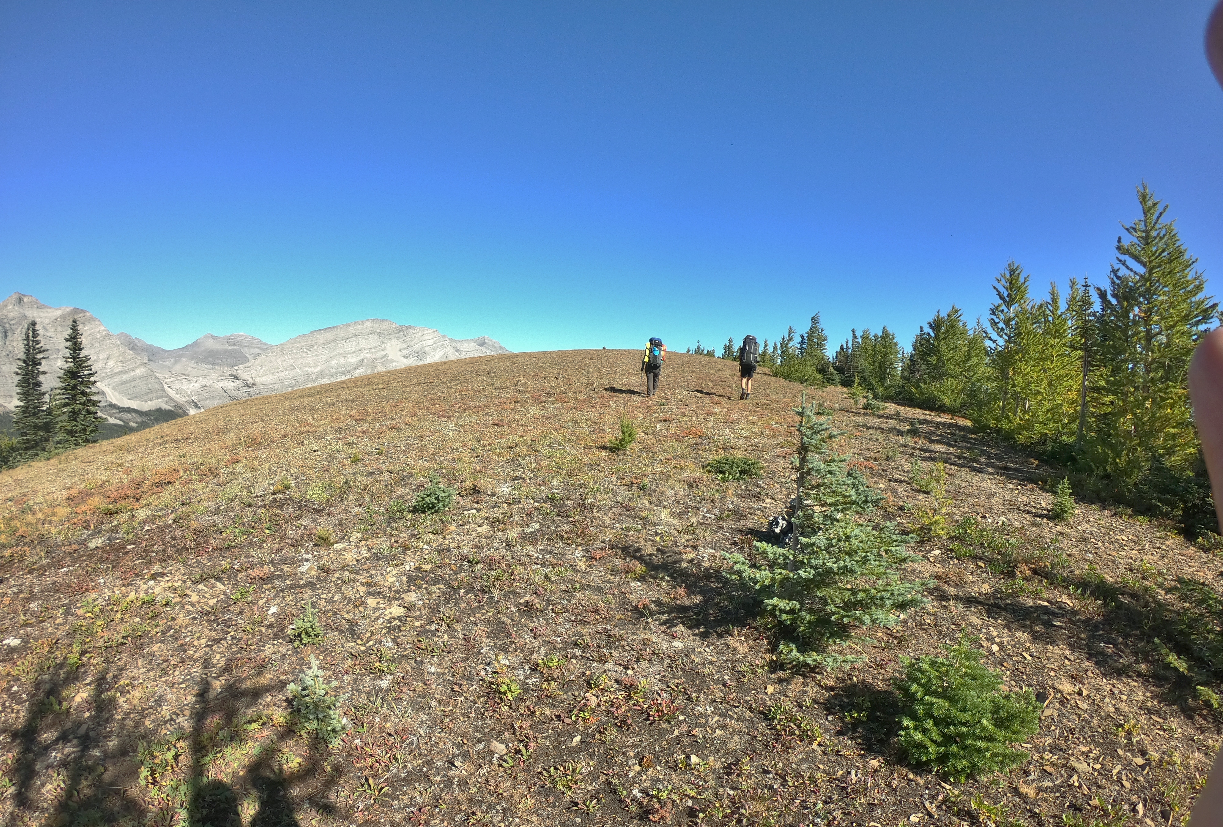
The wait was worth it, the clouds cleared, and we headed up Collie Creek alternate and then onto Amiskwi Ridge alternate. Both alternate routes are fantastic – Collie Creek saves many kilometres of dirt road walking and Amiskwi Ridge has spectacular views if you are lucky enough to have the weather.
The trail out of Cairnes Creek is well flagged and even sign posted for Collie Creek alternate, there has been new trail work done there recently. It is lovely! Collie Creek was probably our toughest water crossing (fast flowing, white water looking) in Section D. But again we had Dustin and River there to lead, and so it was a-okay (definitely easier than the crossings in Section G). There was a very steep up from the creek crossing but the trail was awesome, like going up soft, cushy steps.
Lynnie Crossing Collie Creek
The trail up Amiskwi Ridge (SOBO) was another story… it starts out okay but when you come to the clear cut, it’s very tough going. This might have been because we waited too long to take a break and were hungry or it might have been because the clearcut flagging was pink and not dissimilar to the GDT flagging! It doesn’t matter… we gained the Amiskwi Ridge and it was AMAZING! This section might just be the most geologically diverse stretch of the GDT with various rock formations and fossils; we even stumbled onto a warm spring! Not to mention the spectacular views of the surrounding heavily crevassed glaciers. It is a must do on this section if the weather cooperates.
Views from Amiskwi RidgeMore Views from Amiskwi Ridge
The other alternate route that we did was the Kiwetinok Alternate and I can’t rave enough about this… First the bad news… it’s a tough go with a lot of elevation gain, loss and gain again in a short distance. The toughest part of this alternate for me was the Kiwetinok Gap which really surprised me. It gets very steep near the top of the gap and then over the top there’s a nice walk down a dry river bed until you have to find the very steep, very faint trail (looked like a bear trail to us) through the trees to get down to the meadow. The immediate hike up to Kiwetinok Pass is more demoralizing than difficult! Going SOBO, there is good trail with flagging when you first start the alternate to above the trees on the approach to the Gap and again on the way down from Kiwetinok Pass (thank you Parks Canada!). In between these two areas, you’re a bit on your own (or with GPS). And if you happen to do the alternate northbound, make every attempt to walk backwards up towards Kiwetinok Pass or turnaround often – the views are spectacular!! [NB: Kiwetinok Pass alternate is not safe in early season due to a cornice that forms on the north side of Kiwetinok Gap.]
Hiking up to Kiwetinok GapHiking up to Kiwetinok Pass [notice Kiwetinok Gap top right that we just came down!]Walking Through Kiwetinok PassComing down from Kiwetinok Pass
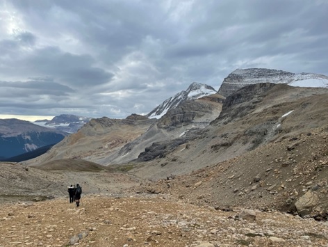
After the walk down from the pass, the trail joins the Iceline Trail and then onto Yoho Lake campground and then Field.
The Iceline
This last part of Section D is fantastic and so worth doing (with the small exception of the last 5 km into Field which had so many horizontal switchbacks that we thought we were going uphill!). We saw the unbelievable glaciers of the Iceline, Canada’s second highest waterfall – Takkakaw Falls, a herd of 30+ mountain goats grazing around the Burgess shale fossils and spectacular views of Emerald Lake and the backside of the President and Vice-President peaks. An outstanding final day! Quick sidebar… Yoho Lake campground is gorgeous, it’s actually on Yoho Lake and comes complete with two red Adirondack chairs to enjoy the view!
I hope you get a chance to do this section with the new alternate routes… it is so worth it!
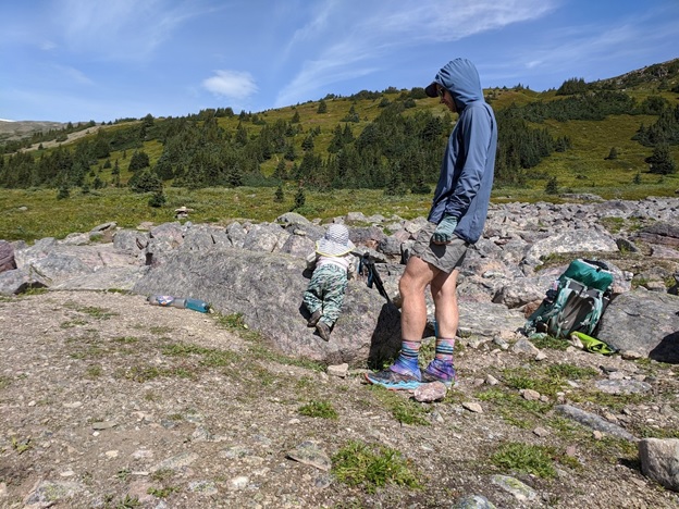
Background:Kyle & Natasha Philibert-Palmer thru-hiked the GDT in 2021 with their 8 month old son “Toothless”. They write about their adventures, including this hike, on their website http://backpacksandbikeracks.com
When we were planning a family, we had one thing in mind: We planned on sharing the outdoors and hiking with our child, and if they would allow us, go on a thru-hike with them.
We never thought at that time we would do another GDT thru-hike with our future infant son. The GDT was, in our minds, something we would do again in 10 years or so when the GDT becomes more popular, better supported and our kid could carry themselves and some of their gear. Maybe we could do part of it along with a Continental Divide Trail thru-hike if we wanted to think big.
When the pandemic hit, we initially thought it would be over after a few months and a Pacific Crest Trail (PCT) thru-hike would be feasible. But after close to a year of travel restrictions, public health measures, and uncertainty with PCT permits we found ourselves thinking, “Is the GDT feasible to hike with a baby?”. After all, we thru-hiked the GDT in 2018 and had a strong understanding of the trail and logistics, and we have been volunteering with the GDTA ever since, and the GDTA has resolved a lot of the challenges we had on our 2018 thru-hike.
After confirming our son (trail name “Toothless”) liked hiking with us (something we’ve now been doing with him since he was 3 weeks old) we started thinking about the GDT in more detail and started planning how we’d thru-hike the GDT with a baby.
Our biggest challenge would be the long food carries. Our biggest fear would be a few of the water crossings.
We helped mitigate the food carries by receiving an incredible amount of support from trail angels who would help us with resupply drops, sending resupply packages to places not on the GDTA list, staying at a lodge one night, and maintaining a good old fashioned calorie deficit at times. This would still leave our packs heavy, but it seemed doable.
For the water crossings, the GDTA built some new bridges, and for the rest we just had to see how it went. We planned a few bail points, planned major crossings to be as early as possible, and accepted the fact we might need to camp out for a day to let the water levels get lower.
We started our thru-hike on July 5th, the same day we started in 2018. This time we planned on taking longer (58 days instead of 49 days) to go less far (to Mt Robson instead of to Kakwa).
We started with uncertainty. There was an unprecedented heat wave – right when we were travelling to the trailhead and thankfully before we started. The longest Toothless had gone backpacking was 6 days (82km on the Sunshine Coast Trail) and we didn’t have a solid daily routine yet. We committed to hike Section A to Coleman, where our car was being stored at A Safe Haven B&B, and decide if we wanted to continue or not while there. If we were not having fun, or if the days are too hard and long, then we would have to call it and change our plans to doing shorter stretches and section hike instead.
The first few days in Section A were hot with more elevation gain and loss than we anticipated, but we pushed ourselves and managed to stick to our itinerary despite late starts and needing to finish early in the evening to feed Toothless dinner and get him in bed. We quickly settled into a routine of alternating between hiking as quickly as possible during Toothless’ naps and extended breaks to let him explore and play in the dirt. This was exactly the confidence boost we needed and by the time we reached Coleman, all three of us were excited to keep going on the trail.
Sections B and C provided us with more great weather and beautiful views. We spent 22 nights in row sleeping outdoors before we reached Field! In addition to enjoying the outdoors with Toothless, we got to see him ham it up and socialize with other hikers on the trail – a welcome surprise as we weren’t sure how our pandemic baby would interact with other people.
Then we hit our first major hiccup of the trip in Section D; I got an overuse injury in my ankle halfway through. So, we bailed off the trail and took 4 days off to rest before skipping ahead about 50km to Section E to stay on schedule and keep our reservations.
Section E is one of our favourites, but unfortunately, this year we had a lot of precipitation. With Toothless we planned doing the section in 11 days. Out of those days we had 7 days of rain and 2 days of snow. This made the section challenging for Toothless since he didn’t get the best of views (hard to see anything when it’s completely white or grey out) or much of a chance to wiggle around. Thankfully the water crossings were straight forward; the Maligne River had the lowest water level we have seen in the past 3 years. While we weren’t worried too much about the Maligne River ford itself, it was a good data point for the remaining water crossings north of here since we have crossed it a handful of times before. But hiking over the Notch in snow was probably the only time on the entire trip I knew we made a bad decision and regretted it. Being up on the Notch with poor visibility, snow, and a phone that turned off due to the cold while we were carrying my child made me very concerned. I was doing everything I could to keep my composure so we could focus on making good decisions as we progressed. Natasha was thankfully cool as a cucumber. A few other groups also got caught up there and we all helped each other out with navigation and ensuring we kept sight of each other.
After our experiences in Section E, we carefully looked at the weather forecast for Section F and opted to finish at the Moose River Trailhead instead of Blueberry Lake (both of which are alternatives to the Berg Lake Trail which was closed this year). Finishing at Moose River allowed us to have a more balanced forecast and cut out a couple days of forecasted heavy precipitation and snow from our itinerary. This worked out for the better and it was overall a much more enjoyable section for Toothless. Knowing how the rest of the GDT is, I was really pleased with the Moose River Trail. The floodplain and trail along the river has the same flavour as several other parts of the GDT north of this, so it felt less like we were bailing and more like we were experiencing the GDT. We also lucked out and finally experienced the trail without wildfire smoke for a sustained period – so we got to enjoy the views throughout the entire section. This was new for us because during our 2018 thru-hike the wildfire smoke was the worst north of Section F.
Hiking the GDT with our son has been the most rewarding experience I have ever had, but it is probably the most challenging thing I have ever done as well. Thinking of these things separately – hiking the GDT in 2018 was the hardest thing I had done at the time. After that, raising our son then became the hardest thing I have ever done. So adding the two together is like hard squared.
Toothless has loved hiking since our first hike with him at 3 weeks old. What he loves is he gets to be carried by his mom or dad, which means being close with us and able to interact with us. During our thru-hike on the GDT he has grown so much. He started babbling, and we make sounds together, have conversations, and sing songs. When singing or in a good mood, he likes to bounce and dance in his carrier. He also started playing peekaboo, which is completely doable in a carrier while hiking. He also still loves just snuggling with us.
He also loves seeing new things and having the opportunity to interact with his environment. Every day on trail, he got to see a new type of tree, flower, or find a new object (like a sign or bear locker) to interact with. Through the GDT he went from noticing objects that are close up to pointing to far away objects and getting our attention. On ridge walks or in a floodplain, he would point to a far away mountain range and say the same thing he says when he sees a tree he wants to touch “da; da; uh”.
He also really loves moving, climbing, and crawling. The wilderness is a great place for him to crawl over and on things. He crawled over “stairs” for the first time on trail and stood unsupported for the first time. I hope to never forget those moments.
It’s easy to be cynical of a trail when you are immersed in it. Maybe you wish there were better climbs or views in a section. Maybe you wish there was actually a trail and not a bushwhack or river route. Maybe the campsites are in poor condition. This is, I think, especially easy to have happen when you have hiked a trail before. But when you hike it with a baby you start to see the wonder through their eyes and look for new or interesting things you maybe haven’t paid much attention to before.
Even though Toothless might not have conscious memories of the trail as he grows older and we encountered several challenges, we would make the same decision again to thru-hike the GDT as a family. I hope he continues to love the outdoors as much as he does now, and that he always reminds us to stop and enjoy the small things on trail too.
Each year we recognize the efforts of our volunteers who have gone above and beyond to help us achieve our objectives. This year we want to recognize the efforts of these 7 individuals whose hard work and dedication were a big part of our success in 2021:
Jim Schieck – In recognition of his important contributions to the 2021 GDTA Trail Building Trips. Jim participated in two trail building crews this past year, serving as a Crew Leader for the first time. Jim’s work as a biologist enabled us to get a bird survey done so that work on Racehorse Shoulder could be completed this summer. Jim and his wife Annette also hiked the entire High Rock Trail to produce a Trail Adopter assessment report.
Dave Higgins – In recognition of his leadership and important contributions to the 2021 GDTA Bridge Building Trips. Dave led bridge building trips this year to Cataract Creek and Cairnes Creek. Just like last year, Dave built not one but two much needed temporary bridges over Cairnes Creek, while dealing with the stressful red tape from difficult government officials. Dave continues to be the main person responsible for the rebuild of the David Thompson Heritage Trail and is leading the charge to get a permanent bridge built over Cairnes Creek.
Tasha Shakotko – In recognition of her important contributions to the GDTA Outreach Committee. Tasha has been a key part of the reinvigoration of the GDTA’s Outreach Committee, working hard to promote the Great Divide Trail and the Association including assisting with the set up the GDTA’s Online Merchandise Store.
Susan Massong – In recognition of her important contributions as TBMC Secretary and Trip Coordinator. Susan became the Trail Building & Maintenance Committee Secretary earlier this year and immediately began improving many of the administrative and record keeping processes of the committee. She took over the role of Trip Coordinator and very successfully managed the communications with dozens of volunteers over several weeks as part of this summer’s trail building program.
Dan Durston – In recognition of his leadership and important contributions to Support the GDT Community and Improve the Great Divide Trail. Dan led a trail maintenance trip to improve the notorious Jackpine Valley Trail this year. He continues to make many other improvements to the GDT, in particular to Section D. Dan always makes himself available to support the GDT community, answering questions and providing planning advice to aspiring thru hikers.
Dave Hockey – In recognition of his leadership and important contributions to Finishing the High Rock Trail and Getting the GDT recognized and protected in Alberta. As usual, Dave was a trip leader for multiple trips on the High Rock Trail, lending his vast amount of trail building experience to a new batch of volunteers this summer. As Equipment Manager, Dave was again responsible for procurement and storage for most of the GDTA’s tools and supplies. In his “spare time”, Dave continues to be the biggest advocate for the recognition and long-term protection of the GDT in Alberta.
Sarah Jones – In recognition of her important contributions to the Trail Protection and Advocacy Committee. Sarah has become an important member of the Trail Protection and Advocacy Committee. Earlier this year Sarah compiled information from several sources to prepare an invaluable briefing document for the board related to the rescinded coal development policy in southern Alberta.
It was Day 2 and we were following Dutch Creek up towards Tornado Pass. There was a bare hill, lots of deadfall to climb over (probably brought down by an avalanche) … and the trail disappeared. It was time to put down our packs, take some GPS coordinates and to take some pictures. We were participating in “Adopt a Trail”, a new program that the GDTA was piloting this past summer. The GDTA’s Adopt a Trail Program is similar to a program currently used by the Pacific Crest Trail and several other long distance trails, used to identify sections of trail that require maintenance. The GDTA can use this information to prioritize the yearly maintenance work and to send out the best resources needed to fix it. Doug Borthwick started this program, part of the Trail Building & Maintenance Committee initiatives.
What do you need to get involved?
A working knowledge of trail building (trail and tread quality, deadfall, protected species). Training and checklist will be available.
Physically fit and able to independently backpack on the GDT.
Ability to collect GPS coordinates and pictures.
Willingness to do simple maintenance as you walk your section of trail.
The GDT has been divided into “adoptable sections” of 15 to 30 km in length. Volunteers have the flexibility to choose:
A section that interests them.
A section that suits their physical capabilities.
Choose the dates to complete their hike.
Coordinate the people that you want to participate in your hike.
We had six days of September blue skies as we hiked the ridges from Dutch Creek to Baril Creek. It was an incredible hike with good friends and a great way to get involved and support maintenance work on the GDT. Look for a roll out of the GDTA’s Adopt a Trail Program in 2022 or contact us now to get involved!
Trail Adopters, Deb and Stuart (photo by Jeremy Bateson)Hiking high ridges on a trail adoption hike, nothing needing maintenance to report up here. (photo by Jeremy Bateson)
Unless noted otherwise, all photographs in this article were taken by the author or Ian Hatter in the Canadian Rocky Mountains.
Is it a pine? Is it a fir? Is it a spruce? And why should I care?
Most people hike through the coniferous forests along the Great Divide Trail without giving much thought to the trees unless they are clambering under or over trunks that have fallen across the trail, or on a Great Divide Trail Association work party removing deadfall and pruning branches. However, it is worthwhile knowing what species you will encounter as you hike and/or work on the GDT and their characteristics, both the pros and the cons.
Big Picture Pros and Cons – To Breathe or not to Breathe
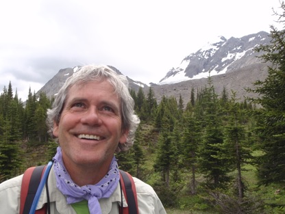
First off, you should know that hiking through natural coniferous forests confers many health benefits and is one of the best things you can do for your physical and mental wellbeing. Conifers exude substances called phytoncides (wood essential oils), which are antimicrobial volatile organic compounds such as α-pinene (pine scent) and limonene (lemon scent). Breathing in these substances helps boost the immune system in human beings and stave off depression and anxiety. Each time I return to the Rockies and inhale its characteristic subalpine fir forest fragrance, it immediately puts me in a good mood. So, appreciate the health benefits you are getting from just breathing in the characteristic fragrances of pine, spruce and fir as you meander through the montane valleys and slog up steep subalpine slopes. Hiking the forested sections of the GDT is the ultimate in forest bathing or “Shinrinyoku” in Japanese.
Hiking through the subalpine forests along the GDT is one of the best things you can do for your health. Ian Hatter at North Kananaskis Pass, August 2011.
Unfortunately, when coniferous forests burn, the resulting wildfire smoke contains very small particles that travel deep into your lungs when you inhale. These particles can cause irritation and inflammation that last until the air quality improves. So, hikers need to be careful not to exert themselves during periods when forest fire smoke blankets the mountains. People with heart and lung disease risk worsening their condition. Even in aerobically fit individuals, wildfire smoke may result in sore throat, irritated eyes, runny nose, mild cough, phlegm production, wheezy breathing, and headaches. It is better to take a rest day. Plus, when it’s smoky, you miss all the great views along the GDT!
What is a Conifer Anyway?
The word “conifer” literally means “cone bearer”. Coniferous trees and shrubs are Gymnosperms since they are woody plants that reproduce by forming a cone to contain seeds rather than reproducing via a flower that becomes fruit. All modern conifers evolved from one now-extinct family of conifers during the Mesozoic Era over 200 million years ago, around the time of the rise of the dinosaurs. The conifers discussed in this article are all members of the Pine Family (Pinus).
While most conifers are evergreen, the term “evergreen tree” is not synonymous with “coniferous tree”. The term evergreen describes a tree’s leaves. Unlike a deciduous tree that drops its leaves in the autumn, an evergreen tree keeps its leaves all year long. In the case of evergreen conifers, their leaves are needles. Each December in North America and Europe, many pines, spruce, and fir “Christmas trees” end up in living rooms with presents under them.
Just to be Different
All conifers produce cones but not all evergreens produce cones. Evergreen trees that are not conifers (broad-leaved flower-producing evergreens) flourish in the tropics. Deciduous conifers exist as well and can even be seen along the GDT. The “larch madness” that afflicts hikers in the Rockies each autumn derives from people’s fascination with the needles of the coniferous subalpine larch turning gold before the tree sheds them. You can read more about this fascinating tree in The Lovely Larch – Coolest Tree on the GDT from the October 30, 2020 issue of The GDTA’s Pathfinder Newsletter.
What are you looking at?
The subalpine larch is fairly easy to tell apart from the other coniferous trees you might see along the GDT, especially in its autumn gold or dormant winter state. So, let’s focus on the most common evergreen conifers that you will see when hiking the GDT. These include the pines (lodgepole and white-bark), the spruces (white and Englemann), the subalpine fir, and the Douglas-fir. There are a few dry places where you may see Rocky Mountain juniper and moister valleys like the Blaeberry in BC where Pacific yew, Western red cedar, Western white pine and Western hemlock grow. However, learning more about these species will have to wait for another article.
Is it a pine? Is it a spruce? Is it a fir?
Discerning Clues from your Location
Sometimes people make the assumption that every cone is a pine cone and thus all the trees they see are pines. Along many parts of the GDT where forest fires prevailed in the past, lodgepole pine still dominates many forests. However, if you look closely, you will see other trees growing in the shade of those pines, including white spruce. In certain drier areas you may also see Douglas-fir rising above the pines. Don’t be fooled; the Douglas-fir is not a true fir. It is a unique type of conifer in its own genus[1]. Along the GDT, you have to ascend to higher elevations (600 to 2,250 metres asl[2]) to see a true fir, the subalpine fir. In snow-dominated forests below the treeline, the spruce you see is the Engelmann spruce. On the high rocky windswept ridges, lodgepole pine gives way to whitebark pine, Canada’s only endangered tree species protected by federal species-at-risk legislation. In western Canada, whitebark pine occurs in a diversity of forested ecosystems, predominantly in the upper montane and subalpine from the Canada-US border to its northern extremity near the continental divide at Kakwa Wildland Interprovincial Park. Usually found around 2400 metres above sea level (asl) in the vicinity of the GDT, the low-elevation extent of the species’ range is around 1700 metres asl.
Searching for Growth Patterns
The overall appearance of a conifer and the way its branches grow provide reasonably good guidance on its identity. Most conifers have strong apical dominance, meaning that the terminal bud (usually, the highest growing tip on the plant) produces indole acetic acid (IAA), a growth substance that inhibits development of apical dominance on any of the lower branches. This is why most conifers have a single erect trunk with a single live top and why it is extremely difficult to use the cuttings from branches of most conifer species to grow trees. However, there is an exception to this trend with significant consequences for GDTA trail work volunteers and GDT hikers.
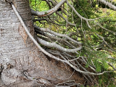
Unlike most conifer species, subalpine fir has weak apical dominance. This species will commonly develop multiple points of apical dominance, usually in one of two situations:
an injury to the growing tip stops IAA production and more than one secondary growing tip independently assumes dominance;
a lower branch grows toward the ground and roots (a process called layering), after which the rooted branch assumes apical dominance independent of its mother tree.
Subalpine fir branches grow toward the ground where they root and form new trees through layering, a form of vegetative reproduction.
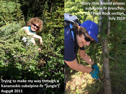
This tendency toward layering allows subalpine fir to reproduce in situations where the growing season is too short for normal cone and seed maturation to occur, most notably in high altitude settings like near the Great Divide. As a result, GDTA work parties can spend many days clearing parts of the GDT lined with subalpine fir whose lower branches have rooted and developed into individual saplings. Removing all of the lower branches and emerging saplings within the clearing zone is a labourious, detail-oriented, and time-consuming task. However, GDT hikers greatly appreciate this pruning and branch removal work since bushwhack backpacking through dense stands of subalpine fir with rooted branches is akin to swimming through molasses.
Hikers who have bushwhacked through dense subalpine fir stands really appreciate the pruning efforts of GDTA trail work volunteers!
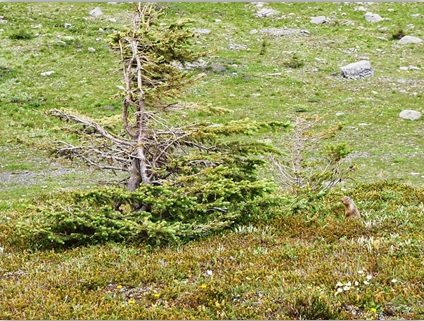
Looking upward, the subalpine fir displays a distinctive tall, narrow conical crown of short stiff branches that help it shed snow in the winter. The crowns can appear somewhat flattened and irregular in older trees. A medium-sized tree usually grows to 20 to 35 metres tall, but occasionally reaches 50 metres in height with a 200 cm d.b.h.[3] Along the GDT, it’s often much smaller due to the harsh environment and occurs as krummholz[4] at high elevations.
Krummholz form of subalpine fir in North Kananaskis Pass (August 2011).
The branches of the straight-trunked conical shaped Engelmann spruce also point down to shed snow, allowing this species to grow at higher elevations than the shorter somewhat stockier white spruce. Engelmann spruce is a medium- to large-sized tree species that grows to 50 metres tall, ten metres shorter than the typical white spruce. Both species can attain one metre d.b.h. Engelmann spruce branches near the ground tend to droop, but fortunately for GDTA volunteer trail builders, do not take root. White spruce have fairly even conical crowns and numerous, densely foliated branches that extend toward or even reach right to the ground. During a sudden rainstorm, taking cover under a mature white spruce along the GDT has helped many a hiker stay dry.
The author hiding out under mature spruce trees during Rocky Mountain rainstorms.
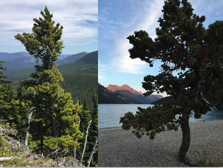
Lodgepole pine typically has a long, slender, pole-like trunk[5] with a short, narrow, cone shaped crown. In the vicinity of the GDT, lodgepole is best known as a tall, slender tree, growing in forests composed exclusively of even-aged, tapering trees of this single species, and whose skinny trunks are free of limbs. Lodgepole reaches a typical height of 70 to 80 feet (21 to 24 m) but usually is less than 15 inches (38 cm) d.b.h. in the southern Rockies.
Less well known is the lodgepole’s ability to assume very different forms from the typical spindly, skinny ‘dog-hair’[6] variety. Single lodgepole pines mixed with other conifers may retain the typical height, developing a thicker trunk reaching a foot or more d.b.h. If conditions are right, it may even keep full foliage right to the ground, although usually lower branches die and remain on the tree. Or it could boast a robust trunk, branching into several equal-sized central stems near the ground, replete with needles from the ground up, and be almost as broad as it is tall. Forms intermediate between the two extremes exist and different forms may be found close by, depending on the available space and light. The short thick form requires full sun for many hours each day, with no other trees crowding it, and above average moisture for the roots. The tall slender form with green branches just near the top is by far the most common one seen along the GDT. However, on ridgetops, from a distance, lodgepole can look as gnarly as a whitebark pine, and you must get closer to verify its identity.
Pine Shape Quiz: Can you tell which tree is the lodgepole pine and which one is the whitebark pine? (Answer at the end)
Speaking of whitebark pine, this subalpine tree also varies in shape. In more favorable conditions, it can develop into a small tree 29 meters (95 ft) in height with a rapidly spreading trunk and broad crown. Or on high alpine ridgetops, it can assume the contorted shape of a krummholtz shrub with a wide-spreading crown and twisted, gnarled branches when exposed to strong winds.
In contrast, the majestic Interior Douglas-fir has a pyramidal shape with an open upright stature. Its lower branches droop and its upper branches point upward. Its lush needles form a beautiful, seemingly downward sweeping canopy. On hot summer days in the vicinity of the Crowsnest Pass, wise hikers seek the shade of these noble giants during their lunch or snack breaks. Mature Douglas-fir (200-300 years old) typically reach an average height of 30 to 37 m (100 to 120 ft) with a d.b.h. between 38 and 102 cm (15 and 40 in). On the best sites, dominant trees may attain a height of 49 m (160 ft) and a d.b.h. of 152 cm (60 in).
Feel your way to your Answer
One of the best ways to tell a spruce from other trees is by using your sense of touch. If you grab a spruce branch, you will likely say, “Ouch!” The individual needles that emerge from spruce tree branches feel stiff and pointy with sharp edges. You can easily roll the narrow needles between your fingertips. Spruce needles are spiny and sharp.
By comparison, if you grab onto the branch of a pine or a subalpine fir, it won’t hurt your hand. While fir tree needles also grow individually on their branches, the needles are soft, flat and fat. They don’t roll between your fingertips. Fir trees are thus much nicer to grab onto when bushwhacking.
So, you can use two mnemonics to differentiate between spruce and fir: “spikey spruce” and “friendly fir”.
It helps to be able to distinguish spruce from fir before you grab a branch!
One caution: the needles on Douglas-firs can be confused with those of true firs because their needles are flexible and thus also soft to touch. However, Douglas-fir needles are spirally arranged on the branch, and due to twisting at the base of each needle they can appear flattened in two rows, a pattern not seen in the needles of the other common conifer species.
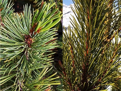
Needle Know-How, Part 1: Looking at these conifer needles, what species are you looking at? (Answers at the end)
Pines are also softer to touch than spruce trees, but their needles tend to be much longer than spruce needles and arranged in distinct clusters instead of individually on a branch like the spruce or the fir. Those clusters hold the key to distinguishing the common lodgepole pine from the endangered whitebark pine. If the needles are in groups of two, you are looking at a lodgepole. If the needles are in groups of five, it’s a whitebark.
Needle Know-How, Part 2: Based on the needles, can you figure out which tree is the endangered whitebark pine and which one is the common lodgepole pine? (Answer at the end)
If you are working on clearing the GDT, differentiating whitebark from lodgepole pine is the most important conifer ID fact you need to know. Every whitebark pine tree, no matter its age or condition, is protected by law, so you cannot cut them or harm them in any way. If you do, not only are you are in violation of the Species at Risk Act and regulations, you risk jeopardizing the positive reputation and future work permits of the GDTA. Remember the mnemonic, “Needles in groups of five, keep it alive. Needles in groups of two, I can cut/prune you.”
GDTA trail work volunteers must check to see if a pine has needles in groups of two or five. If the latter it is an endangered whitebark pine and must be left alone.
Clues in the Cones
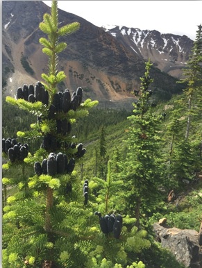
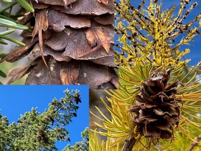
Conifer female or seed cones (as opposed to male pollen cones) vary with the type of conifer (spruce, fir, Douglas-fir, pine) and by individual species. As you wander through the forest, if you can see the seed cones on the conifer tree you are wondering about, they will help you identify it. Spruce and pine cones hang down from the top of the tree. Subalpine fir cones point upwards and display an interesting purplish colour.
Most cones hang down but subalpine fir cones point up. Tonquin Valley, Jasper National Park, Alta. July
Douglas-fir cones are unmistakable. They are the only ones you will find along the GDT (and in fact, in the entire Pacific Northwest) displaying distinct, three-pointed bracts sticking out of the scales. Unlike the true firs, Douglas-fir cones hang down rather than standing up on the branch. Also, unlike the true firs, the Douglas-fir drops its cones to the ground intact. If you see these unique cones on the ground, that’s your clue that you know there is a Douglas-fir nearby. The appearance of these cones led to fascinating Indigenous stories[7] about the origin of this species. Subalpine larch seed cones also have bracts that are much longer than the cone scales but the trees are so different looking and grow in such different habitats in the vicinity of the GDT, that it is highly unlikely that one would have trouble distinguishing them. Subalpine larch seed cones are also considerably smaller than Douglas-fir cones.
Douglas-fir cones (left) and subalpine larch cones (right) both have mouse-tail shaped bracts but larch cones are much smaller
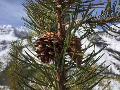
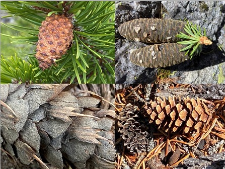
The cones of pine trees vary with the species. The roughly egg-shaped cones of lodgepole pines are light brown, approximately one to three inches (three to seven cm) long and have sharp prickles on their scales. Whitebark pine have similarly sized (three to eight cm) egg-shaped to almost round cones that grow at right angles to the branch with scales growing in roughly five spiral rows.
The unique cones of the whitebark pine grow at right angles to the branch.
To complicate things, lodgepole pines produce two different types of seed cones (closed or serotinous and open or non-serotinous). The serotinous[8] cones often remain tightly sealed and on the tree until exposed to fire when they open. Serotinous cones require temperatures of 113 to 120 degrees Fahrenheit (45-50 degrees C) to melt the resin that binds the scales of the cone, temperatures that generally accompany moderate to severe fire, so they can open and release seed. These cones are well insulated with resin to survive brief periods in flames. Individual pine trees predominantly bear either open or closed cones, and most mature Rocky Mountain lodgepole pine stands contain trees that have both types of cones Though Rocky Mountain lodgepole pine may start bearing cones at less than 10 years of age, serotiny is usually not expressed until trees are 30 to 60 years old.
Hedging its bets, this 15-year old lodgepole pine near the divide in Kootenay National Park produced one of both types of cones, open (left) and closed (right).
In contrast, all whitebark pines cones stay permanently closed and the wingless seeds are released only when the cones fall to the ground and decay or when animals pry open the cones seeking the large (about the size of a pea) seeds. Several wildlife species rely on these high-fat, calorie dense, protein-rich seeds as a vital food source, most notably the Clark’s nutcracker, but also the red squirrel, plus grizzly and black bears. Clark’s nutcrackers use their long, pointed beaks to break apart the large cones and remove the seeds. The birds cache the seeds just under the soil surface at lower elevations and often at above ground locations at higher elevations to ensure a reliable source of food for winter. They use adjacent rock and wood debris to create triangulated memory maps that assist them in relocating the seeds when needed. An individual nutcracker may cache up to 98,000 seeds in a year, as far as 30 km away from the source tree! Roughly half the seeds cached are not retrieved for various reasons and many of these germinate and grow into pine seedlings.
The seeds of Rocky Mountain lodgepole pine are small, winged and thus disperse easily with wind. Rocky Mountain lodgepole pine has two modes of seed dispersal, based on cone serotiny. In Rocky Mountain lodgepole pine stands with predominantly serotinous or closed cones, the most important method of dispersal remains the releasing and scattering of seed on the forest floor after fire opens the cones. This leads to the development of extensive even-aged lodgepole pine stands so prevalent along much of the GDT. The non-serotinous or open cones allow seed release to occur at various times, creating lodgepole pine forests of varied ages and often mixed with other tree species.
Using seed cones to identify spruce species is another matter altogether. White spruce seed cones are light brown to purplish and hang from the upper branches. The seed scales have a smooth, rounded outer edge. Engelmann spruce seed cones are slender, cylindrical, yellow to purplish brown and pendulous, hanging from the upper branches. Their papery-thin, flexible seed scales are tapered at both ends and have a ragged or wavy outer edge. White spruce cones are smaller than Engelmann spruce cones[9]. However, although pure Engelmann spruce cones and pure white spruce seed cones look different, these tree species hybridize and that can affect seed cone size and appearance. If you happen to see the male pollen cones, the white spruce pollen cones are pale red whereas Engelmann spruce pollen cones look yellow to purplish-brown.
Cone-undrum: name the species for each cone (Answers at the end)
Barking up the Wrong Tree?
The bark of the conifer trees along the GDT tends to be less helpful in identifying species except in a few cases. Subalpine fir has characteristic silver grey bark with distinct resin blisters. Older Douglas-fir trees have thick insulating bark, an adaptation to help the tree resist light intensity forest fires. Mature sub-alpine larch trees also possess thick fire-resistant bark.
Real or faux fir? Can you identify the species based on its bark (Answers at the end)
Ironically, the whitebark pine’s bark doesn’t really look white, except when very young and smooth when it is sort of a greyish chalky-white colour. As the tree ages, the bark becomes tan or brown and breaks into narrow scaly plates one or two cm thick.
The bark of a whitebark pine is actually more light grey in colour, becoming darker with age.
In terms of the easiest tree trunks to blaze, GDTA blazing expert Dave Higgins says he prefers the subalpine fir. “Next might be whitebark pine, if it weren’t for its protected status. Both these trees have bark that needs no scraping and one application of paint adheres very well for a long time. [Subalpine] Larch has to be scraped and usually needs two paint applications with drying time in between. The bark of spruce is similar, and both these are less than ideal because the bark continues to grow and flake off over time. Lodgepole pine would be 2nd from last on the list as they’re more likely to have a short remaining life if they’re large enough to blaze in the first place. Dead last would be [non-conifers] aspen or poplar due to their tendency to die seemingly at random.” Dave doesn’t mention Douglas-fir but they would likely be similar to spruce. They are harder to blaze as they age and develop deeply furrowed bark.
The author gazing at a GDT blaze on the trunk of a subalpine fir tree, Oldman headwaters, August 2010).
Common English Names Only Part of the Story
Of course, the names used so far in this article are not what the various Indigenous peoples along the GDT route[10] called them. Indigenous people made use of various conifers and like other aspects of the natural world respected them as relations with whom they were connected physically and spiritually.
Many First Nations had names in their own native language for various types of conifers although a one-to-one match between the Indigenous names and the scientific species names does not always exist. For example, the Secwepemc referred to what we call subalpine fir as melénłp, məlénłp, menenpéłp (all ‘medicine plant’) whereas the Ktunaxa called it nisnap, nisnapułał or t’isłúłał. First Nations utilized the nutritious seeds of the whitebark pine. The Secwepemc called the edible seeds stsek’ and the tree stsek’éłp (cf. estsek’ “squirrel” + -ełp “plant”). The Ktunaxa words were q’anłat’ana and q’anłat’anał. Known as apahtó’kii by the Káínai Nation of the Blackfoot Confederacy, lodgepole pine held significance for the culture of the Blackfoot people in a variety of ways, as it did for other First Nations. The Secwepemc called the tree itself qw liʔt or qw eqw líʔt (plural) and had names for the edible inner bark (stiʔqw ’əl’q) and the outer bark (p’əlen). The Ktunaxa called the tree ʔiłtit’ and the edible inner bark ʔaknaq.
Scientists use a binomial nomenclature system based on Latin for conifer and other organisms so no matter what language they speak they can communicate with one another about a particular species. Scientific names identify the genus and the species. The species name describes some aspect of the species (e.g., Pinus albicaulis means a white-stemmed pine), or commemorate a scientist (e.g., Picea engelmannii is named for George Engelmann (1809-1884), the botanist who first described the species for science). The common English and scientific names for the primary conifer species along the GDT appears in the following table.
Common Name
(English)
Scientific name
(Genus species, subspecies or variety)
lodgepole pine
Pinus contorta, var latifolia
whitebark pine
Pinus albicaulis
subalpine fir
Abies lasiocarpa
Engelmann spruce
Picea engelmannii
white spruce
Picea glauca
subalpine larch
Larix lyallii
Douglas-fir
Pseudotsuga menziesii subsp. glauca
The use of names for things helps communities of people (be they a First Nation, the western scientific community, or GDT hikers) recognize things in a similar way so they can meaningfully communicate with one another.
Tree ID as a Mindfulness Practice
Besides providing practical information of benefit to a hiker or GDTA volunteer trail builder, learning to recognize the various conifer identities can serve as a mindfulness practice. While not as all-encompassing or immersive as “Shinrinyoku” (forest bathing), nevertheless it facilitates slowing down, being present, and using one’s senses, things that improve one’s mental and physical wellbeing, something we should all care about.
Where coniferous forests have not been logged, tree appreciation along the GDT continues for decades.
Answers:
Pine Shape Quiz: That straight-trunked tree on the subalpine ridge is a whitebark pine, and the round spaciously branched tree along the shore of Upper Waterton Lake is the lodgepole pine.
Needle Know-How, Part 1: Clockwise – White spruce, Engelmann spruce, subalpine-fir, Douglas-fir
Needle Know-How, Part 2: The bushy-looking branch on the left with needles in groups of five is on a whitebark pine. The tree on the right has needles in bundles of two and thus is a lodgepole pine even though it is obviously at a high elevation.
Cone-undrum: Clockwise – the closed serotinous cone of a lodgepole pine, the oblong sappy purplish cones of a subalpine fir, the characteristic mouse tail bracts tell you this is a Douglas-fir cone, and the fourth cone is for sure from a spruce, probably an Engelmann spruce, given the ragged or wavy outer edge of the scales.
Real or faux fir? The true fir, the sub-alpine fir, with its characteristic silvery-grey bark with distinct resin blisters is on the left. The deeply furrowed fire-resistant bark of a mature Douglas-fir, which is not a true fir, is on the right.
Footnotes:
[1] A genus is a biological classification ranking between family and species, consisting of related species.
[3] DBH or d.b.h. is a forestry term to standardize tree girth. It stands for diameter-at-breast-height.
[4] In German, this means “crooked wood” and refers to the stunted wind-blown trees (of any species) growing at high altitudes just above the timberline.
[5] The common name “lodgepole pine” comes from the custom of Indigenous peoples using the tall, straight trees to construct lodges (tepees). Interestingly, the scientific name Pinus contorta means “contorted pine,” and originally referred to the contorted shapes of these trees where they were first identified by botanist David Douglas along the shores of the Pacific Ocean. The variety name latifolia refers to the curved cone axis.
[6] An expression referring to very dense thickets of small even –aged slow-growing lodgepole pine trees growing as thick as the hair on a dog’s back and typically arising following a forest fire.
[8] Serotinous – Remaining on a tree after maturity and opening to release seeds only after exposure to certain conditions, especially heat from a fire.
[9] White spruce seed cones are about 1.25 to 2 inches long (3.175 – 5.08 cm) whereas Englemann spruce seed cones are 1.57 to 3.15” (4 – 8 cm long) and .59” (1.5 cm) broad when closed, opening to 1.81“ (3 cm) broad.
[10] The Great Divide Trail passes through the traditional territories of the Blackfoot Confederacy, Tsuut’ina, Ĩyãħé Nakoda, Cree, Lheidli T’enneh, Ktunaxa, Secwepemc, Sinixt and Métis.
For this year’s Trail Building & Maintenance article we decided to let the volunteers tell in their own words about the trail crew trips. Over and above these reports there was one major “Scouting Trip” early in the spring, which besides setting the stage for all the High Rock trips, resulted in some major switchback building north from Window Mountain Lake. Also there were our first “Adopt a Trail” trips to test a new way to monitor and perform needed light maintenance on sections of the GDT. There is a separate article explaining them. In the meantime enjoy these volunteer trip reports and their stories.
Trips 1, 11, and 12
by Paul Jollymore
Three years ago my wife and I were enjoying a motorhome tour of Europe, when I thought to myself, that hiking in the mountains with a backpack held little appeal. Way too much effort. Upon our return home I realized that chocolate croissants were not on the recommended guidelines for daily breakfasts, and a demand for a fitness routine prompted me to the GDT. I’d completed Waterton to Sunshine in 2020, then the Rockwall to Saskatchewan River Crossing in 2021, and Jasper is planned for 2022. Joining the GDTA in 2020 was a great way to contribute to a trail I intended to use. Plans were in a flux in 2020 due to Covid but significant work was made along the High Rock Trail.
In 2021, the call for volunteers was disrupted over the winter but June approached and the preliminary bridge building project at Cairnes Creek – Trip 1, got the green light just in time. Enroute to the site, a road washout prevented progress so plan B prompted Dave, Doug, Rob, and I to head to the Atlas staging area north of Blairmore to do a little work on an alternate trail bypassing a section of road walk.
A second attempt at the Cairnes Creek bridge project – Trip 11, later in June brought Dave, Robert, Rob, David, Linnie, Doug, Tommy, and I out in an attempt to drag a generous size log across the creek as a suitable crossing. Our chainsaw winch and rigging wasn’t quite up to the task so a temporary crossing was left in place to accommodate foot traffic for the season. Our crew also headed to Lambe Creek crossing, clearing some trail along the way, and completed a repair job on the handrail at the bridge.
The third attempt – Trip 12, was made early in September when Dave, Rob, Robert, and I returned to Cairnes Creek with more rigging hardware. Robert provided us with a setup that managed to wrestle a 2.5 tonne log 40 feet across the creek without it even touching the water. Kudos to a well executed plan!
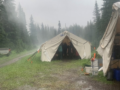
Each of these work parties required members to bring their own camping equipment and food. A common shelter area and cooking facilities were provided. Members had to come prepared to daypack to a worksite, pack a lunch, and bring suitable clothing for the day. While each of these work parties had a clear objective, the leads remained flexible when facing obstacles and reasonable alternatives were adopted as we went along. The work was strenuous but never overwhelming and the participants all expressed positive feedback on the experience.
I completed my GDT hike through the Cairnes Creek section in July and stopped for a break and encountered two other GDT hikers NOBO, and one hiker SOBO, as well as a family of four out for a dayhike in the 20 minutes I sat there. Andrew was the SOBO thru-hiker who completed the entire GDT in 20 days, aiming for 60 km per day and setting a record for the GDT’s Fastest Known Time in the process. The trail is only going to become more popular and it’s rewarding to know that our efforts contribute to the success and enjoyment of others.
Trip 2
by Melanie Sampson
The cool mountain air is crisp and the larch trees have turned, adding a splash of vibrant gold across the landscape along the Great Divide Trail. After an unusually hot and dry summer, the change in temperature is welcomed. During this transition of the seasons, I find myself reflecting on some of those long summer days; this year, I look back upon my incredible volunteer trail building and maintenance trip with the Great Divide Trail Association, and do so with much gratitude.
My name is Melanie and I have lived in the Calgary area for over a decade and have made our nearby Rocky Mountains a huge part of my life. I love to hike, trail run, crosscountry ski, bike, and am usually even keen for a swim in frigid glacier waters. I have built a career in aviation that allows me to travel all over the world, but when my feet are back on Canadian soil, I am typically mountain bound. With the slowdown of travel throughout the Covid-19 pandemic, I have been able to spend more time exploring our nearby trails, and found myself gravitating towards taking part in one of the GDTA’s trail building and maintenance trips. I was fortunate enough to sign up for Trip 2 along the High Rock Trail in the Crowsnest area. I had no prior experience with trail maintenance and was relying on the instruction and guidance of Trip 2’s crew leads, the positivity and encouragement of my crew mates, and my own eagerness to contribute to this ongoing project that is, quite frankly, remarkable.
Upon our crew coming together and meeting each other for the first time, we quickly bonded over our shared love of the trail, exploring wild places, and this magnificent thing called the Great Divide Trail. Together we shared stories from the trail; our favourite backcountry snacks and meals, how to make said meals from scratch and as close to gourmet as possible, swapped gear recommendations, and of course, shared tales of everyone’s previous wildlife encounters. While we all came from different walks of life, with varying degrees of experience building and maintaining trails, we came together naturally to dedicate a week of our time for the betterment of the trail so that others, like ourselves, could enjoy the beauty that lies within the Crowsnest area.
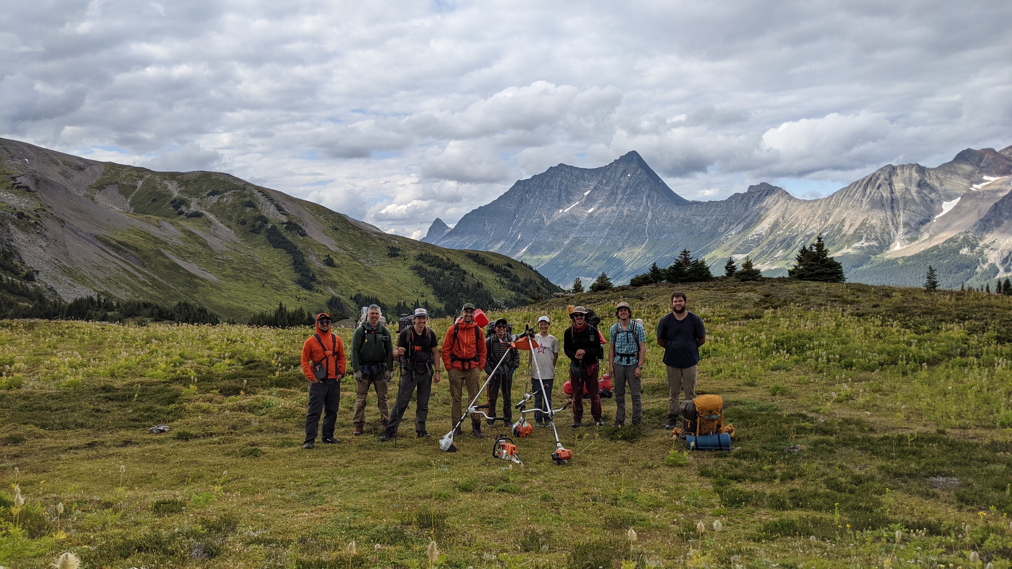
The days were extremely hot – topping out at 37°C! – but our team worked tirelessly, as we were all keen to make our trip leaders, Dave Hockey, Doug Borthwick, and Peter LaBastide proud. What our group was able to accomplish was incredible; the Scout Clearing team was able to flag and chainsaw nearly 2 km of new corridor south of camp, while the Tread team cleared blowdown and improved 3 km of trail north of camp, built new tread for 200m in the First Creek Valley, and 160m of new trail towards Racehorse Shoulder. Trip 2’s crew led the way and set the standard for the next six trail crews to follow, and the first 160m of trail built was used as an example for the next 5 km of trail up and over Racehorse Shoulder that saw more than 200 grateful hikers this summer. What an accomplishment!
I feel very honoured and grateful to have been able to spend a week with such fine individuals, who were all so inspiring and dedicated to maintaining, protecting and promoting the Great Divide Trail. I’d recommend taking part in a trail building trip to anyone, especially if our Rocky Mountains held a special place in their hearts; what a fulfilling experience! Thank you, Great Divide Trail Association for your incredible work; I’m already looking forward to next year!
Trip 3
by Emily Mayes
My name is Emily and I am an undergraduate student at McGill. I stumbled upon the GDTA website and signed up for this trail maintenance trip without knowing much about the Great Divide Trail or any idea of what to expect. I am so glad I did! I could not have asked for a better opportunity to learn about the trail building process and to spend some time in the mountains.
The trip was a resounding success. Most of us were first time volunteers with the Great Divide Trail and had little previous trail maintenance experience. We learned a lot from Doug, Dave, Peter, and the returning volunteers. I really can’t thank the trip leaders enough for sharing their knowledge and for their constant support and kindness. What our team might’ve lacked in trail building experience, we made up for with enthusiasm. It was energizing and motivating to be working alongside people with such passion for the mountains and the Great Divide Trail.
Trip 3 was a hot one. It had been +35C degrees for a week across most of Alberta and BC when we arrived at camp. It was slightly cooler in the mountains, but we were very much still in the midst of a heat wave every day of trail building. It didn’t slow us down too much though! Everyday we’d hike a very convenient 5 minutes from base camp to the start of our trail. From there we’d split into a few groups – scouters/chainsawers, trimmers, pulaskiers and then a finishing crew. Doug was great at noticing people’s predispositions for specific jobs and the work went very smoothly. We plugged along, breezing through sections of nice soft earth and taking our time on various other terrains permeated by stumps, roots and rocks and on intense side slopes. All said and done, we managed to complete about 1.3 km of beautiful 15 degree grade trail, nearly completely free of tripping hazards. (I will never be able to walk a trail and take it for granted again.) After four days of intense sunshine, the weather cooled down and we woke up to foggy skies instead of mountains on the final day. It rained on our way back down to the Atlas Staging Area and the rain was such a wonderful (and refreshing) conclusion to such an incredible week.
Trip 4
by Doug Borthwick
This trip saw the second of three youth groups help with building new trail. The Outdoor Council of Canada (OCC) on this outing, Crowsnest Bible Camp on the previous, and the Junior Forest Rangers on Trip 7, were major drivers to get this year’s work done up and over Racehorse Shoulder. Their youthful vigor and enthusiasm inspired other veteran trail builders immensely.
Trip 4 was the only one other than the Jackpine (Trip 10), which saw any significant rainfall during a very dry and hot summer. There were two nights of heavy rain and hail and the new tents and wood stove were very much appreciated.
This trip was the final one for the forward crew of trail blazers and chainsawers to finish their work, and at the end we said goodbye to Dave, Peter, Julien, and Jim. The tread crew built another hard earned 1.2 km of new trail.
The OCC having now become veterans, recruited an amazing cook to add to their camp. There were usually lots of leftovers, and Allistair was front and center showing the rest of the camp how to properly yogi an extra meal. I really don’t think we worked this crew hard enough as every morning at 5am, we had one ambitious volunteer who had to complete a 5 km trail run before breakfast. The last day the heat and dry weather returned and this crew was glad to dry out before heading home.
Trip 5
by Cody Hemmerling
I am Cody Hemmerling, a fourth year university student that took part in High Rock Trail (HRT) Trip 5. I signed up for the trip because I thought it was a great way to get involved with the GDT, and it provided an excellent opportunity to spend a longer amount of time in the bush. My experience was so much more than that. We had a small crew of seven, and while these people were complete strangers to me before the trip, by the end of the trip it was sad to leave them all, even the girl who wouldn’t shut up about Denny’s ?. It is really true that the outdoors brings people together.
I remember the first day Doug mentioned that the average volunteer makes about 20 metres of new trail in a day and thinking to myself “that seems like nothing, I bet I will do so much more than that”. Turns out Doug knew what he was talking about, trail building is hard work. We ended up finishing the switchbacks on the north side of Racehorse Shoulder before blazing a trail across Racehorse Shoulder, and beginning to build the trail coming down the south side towards Racehorse Road. We were fortunate enough to meet around 20 thru-hikers throughout our trip, all from different backgrounds, with a surprisingly high number of hikers hailing from Quebec.
Highlights of the trip included working atop the stunning Racehorse Shoulder, seeing mountain goats, and above all else the time spent in camp storytelling and hanging out with such an amazing group of people.
Trip 6
by Jeremy Bateson
In mid-July 2021, the GDTA ran Trip 6 to Cataract Creek on the Original GDT. Dave Higgins led a group of six people to install a new bridge over the creek and a smaller bridge across a nearby gulley. A helicopter and personnel from Alberta Parks dropped the 30 foot bridge logs across the creek as well as all the tools. The work crew hiked in 4 km from a nearby logging road access and set up tents around an old snowmobiling shack. Dave tried out a small motor bike and trailer to bring in extra load, but the trail proved to be too boggy. The bridge construction went well. As it turned out, six people was a very good group size for this work.
To start the creek work, the remains of the old bridge were cut away and cleared. After the sills were prepared, the logs’ ends were shifted into position. Dave brought a small chain fall with tripod to help shift the log ends. Once the work was done the tripod legs were used as additional materials. The group made an improvised winch with two 2×4’s to drag the logs to final position. The bulk of the bridge was complete and braced by the end of the second day. The bridge deck was finished with planks and an edge runner.
On day 3 the main group headed up the slope to bridge a large gulley. The gulley bridge was made with locally felled trees and was mainly complete by the end of that day.
On the final day the group walked back to the ridge north of Lost Creek, doing general trail maintenance as they went. They cleared some minor blowdown and trimmed back overgrowth.
The overall trip was a success and accomplished a lot of work with a small team. The use of a helicopter for select work was definitely a benefit.
It was a pleasure to see many hikers during the four work days. At least 10 people passed the crew and shared their insights with the crew.
Trip 7
by Kathleen Gallagher
Trip 7 began at a very civilized 11:30am at the Atlas Staging Area near Coleman in Crowsnest Pass. There I met my friends for the week: Jud, Christine, and Tom, a small but mighty crew. After a quick backtrack into town to pick up some washers to repair the hose, we were ready to drive up the gravel road to the snowmobile staging area where we would hit the trail. As we neared the parking area, out popped Doug on an ATV from the trees, smiling, waving and ready to embark on another successful week of trail building.
Unbeknownst to me, Doug would be towing our gear on the ATV, to the base camp for the week. Truly a missed opportunity since I had packed “backpacking” style. Next time I’m bringing a cot! A quick jaunt up the road and we arrived at our luxurious accommodations: two large common area tents, one for the food preparation/cooking and another for lounging, complete with a library of Great Divide books and a woodstove! We set up our individual tents and Doug gave us a tour of the camp, instructing each of us on our duties. The brave campers touched the live wire for the bear fence to ensure it was working, Christine and I did not. The bugs were crazy bad that first day but got better as the week went on (not sure if that is related to my tolerance or actual conditions)!
The first day as we walked to our worksite, Doug gave us tips and tricks, pointing out challenges and opportunities experienced by the previous groups. His teaching speaks for itself as we were spoiled by the beautiful trail that had been created by the volunteers before us, providing us with smooth sailing and a seamless hike to our starting point. On our commute to work we were fortunate enough to travel over a beautiful ridge, treated to magnificent views of Crowsnest Mountain, Seven Sisters Mountain, Mount Ward and the valley below. I had been a bit nervous about using the heavy and sharp tools required for trail building in the wild, but after a few minutes watching my skilled colleagues Jud and Tom, I felt up to the challenge! I’m glad I tried it out since trail creation is so rewarding! It felt awesome to demolish giant roots and also to look back at what we had achieved each day and think about how we were contributing to a little piece of history.
Day two and three were our main working days and our supervisor Doug was not too tyrannical. Some breaks were allowed and we even had lunch off! I would escape off to the beautiful ridge at lunch to catch some wind to cool off in the heat. An added bonus would be if the gusts blew the bugs away. All in all we had spectacular weather, not a drop of rain and I couldn’t have asked for anything better. Day four was a more lenient day, as it was the last and everyone was rather tired. Still, we built about 330 metres of trail through varied terrain, which we were happy with as only a four person group. 330 metres doesn’t sound like much on a 12,000 metre trail, but a journey of a thousand miles starts with a single step and that is 330 metres that wasn’t there before! I know that the folks that were going in straight lines up and down ridges with no gentle switchbacks to smooth the elevation appreciated it – they even brought us beer!
On our last night to close out the trip, Bartender Jud was generous with his supplies, and Tom and Doug shared countless stories from their past years of trail activities. Christine finally revealed her age to us and went from very impressive to legendary. Thank you to my wonderful companions of various backgrounds for coming together and sharing such a great week with me. I still smile every time I remember the sense of accomplishment and I can’t wait to get back out there next summer!
Trip 8
by Sebastian Kanally
The backcountry, an important refuge. The pristine mountain air fills you with life, the human noise was left behind hours and days ago, the backcountry is a palate cleanser, the backcountry is always there to remind us who we really are.
I am Sebastian Kanally, I live in Amherstburg, Ontario, and the mountains have called my name ever since I first laid eyes on them in 2018. I flew out to hike in the mountains this year- 2021, and I saw the email that the GDTA was looking for volunteers to help build sections of the Great Divide Trail, and I could not pass up the chance. I am a philosopher that is humbled by our natural world. This was an awesome opportunity for me to give some of my labour to the GDTA and meet a diverse group of people interested in volunteering and the backcountry.
Volunteering with the Great Divide Trail Association is a truly enriching experience. I had never done it before, and the experience exceeded my expectations as it was lots of fun. I enjoyed learning how trail is built and why trails are built the way they are. It is a great experience to look back at a day’s work, to see a trail there that was not there the day before. The hard work you put in that day to help build a trail so that others can see these beautiful places. My small amount of work comes together with hundreds of other volunteers to help hikers and equestrians of all abilities to experience the sublime nature of this landscape, in this small corner of the largest intact land biome left on earth.
To volunteer one’s time to go live in the backcountry, no cell service, just living a truly minimalist and essential life, limiting one’s footprint and working collectively to achieve a goal, is brilliant. The walk to work is stunning. The greatest part of the trail building experience for me was learning and developing a more intimate knowledge about this beautiful landscape. The intricate and symbiotic relationships between all the plants and animals, such as the White Bark Pine, the Larch and Spruce trees, the Clark’s Nutcracker, the Grizzlies, and how this is all being impacted by climate change and human activity. The ecological wholeness of this pristine environment demands our respect and work to protect. You can learn about it, but until you spend time and actually experience the landscape it is hard to appreciate how complex of an ecosystem this is.
If you are looking for a fun way to get out into the backcountry with a group of people, I would highly recommend trail building with the GDTA. In an era of climate changing our ecosystems, to meaningfully contribute and do so with an organization that values keeping the ecosystem intact, is priceless. Different people bound by their passion and appreciation of the Rocky Mountains made this a very fun and enjoyable experience. These are amazing people and friends I never would have met without volunteering. All these different demographics coming together truly speaks to the value of building trail and volunteering with the GDTA.
Trip 9
by Doug Borthwick
This trip almost never got off the ground and was very close to being cancelled. What had started as a promising crew size of nine had seen multiple last minute cancellations to come down to a final crew size of three with an added trip camp manager. A last second appeal brought out two fresh young recruits – Mark and Shawn, who worked back to back trips with no breaks. Combined with the Junior Forest Rangers working the changeover day, Jud leading, Stuart staying an extra changeover day, and three camp managers on Trips 7 and 8 wanting to help with the trail work, the three Canmorians who drove through the night to help for two critical days, and the dedicated work of all the original crew members, we were able to complete the remaining 1.5 km of trail south of Racehorse Shoulder. There cannot be enough thanks to this amazing group who were critical in finishing the final connection to Racehorse road.
The volunteers who worked Trip 9 were treated to a meeting with two of this year’s GDT legends. First was Andrew Cottrell who came flying at the group from the north during his record Fastest Known Time (FKT) 20 day hike of the GDT. This guy had time to stop and kibitz for a long time with the trail crew and in fact had to be encouraged to leave so they could get on with building more switchbacks. The second was Peter Whitehead, the 77 year-old who’s thru-hiking story inspired so many. Peter did not have any switchbacks to work with as he climbed determinedly from Racehorse road but he still had a laugh and a joke as he passed the trail crew trying desperately to get just a couple of extra meters done to help him on his way.
This crew amazingly finished their goal of attaining the road one full day early.
Trip 10
by Samuel Yamamoto (Prepper)
I’m someone relatively new to backpacking and thru-hiking, and I’m working my way up the GDT in sections over many summers. Last year I had the pleasure of doing Section A from Waterton to Crowsnest Pass and I was hooked! This summer I was going to embark on my own solo excursion on Sections B and C of the GDT until I saw the call for volunteers to help with trail maintenance in the Jackpine Valley. The dates lined up perfectly for me and being flown out by helicopter sealed the deal. I emailed Dan Durston right away to let him know I’m interested and available, and thankfully I was chosen to go. The journey started with about an 8.5 hour drive to McBride, BC from Lethbridge, followed by about another 45 minutes on a dirt road to where the helicopter would pick us up the next morning. Our crew consisted of nine of us from Alberta and BC.
During the first night, it gradually started raining and did not let up. The helicopter came in the rain after a search and rescue delay. We were dropped off just short of the peak of Big Shale hill where the peak was too socked in to be dropped off safely on it. It took the helicopter three trips to get all nine of us, our gear, and trail maintenance gear up. The trail maintenance gear included three brush saws, three hand saws, three large cutters, one chainsaw, and a ton of fuel in jerry cans to match. In addition we had several trail cameras to monitor trail traffic and wildlife that needed to be set up, and some cans of orange spray paint to “blaze” the trail. We started right away at the treeline on clearing the trail. At first we had three crews of two, a brush saw operator and another to follow, clearing the trail of cut debris. Chainsaw operator and spotter were together throughout the week as they were the only ones that had been trained and certified, and then a swamper in the back. We worked through the rain on day one with little glimmers of sun giving us a small reprieve from the rain.
We set up camp at the end of day one and I discovered most of my gear got wet through and through. My sleeping bag was about 50% wet and I was worried I was going to have major issues through the night. When I started warming up, even in my wet bag, I realized it was going to be okay. We also coincidentally had 7 X-Mid tents by Dan Durston on the trip! In the beginning of day two we had to ford our first of many river fords. By this time, the rain clouds had subsided and we welcomed the warm sunlight.
Day two was working mostly uphill toward another ridge where our pace quickened as we went back up the treeline and the foliage of the trail lightened up. We averaged about a kilometer an hour with our pace. We also changed to a lead team of three brush saws, sweep, followed by the chainsaw and spotter, then three in the rear sawing and cutting brush and trees as well as clearing debris. By this time we had found a groove that was working for all of us.
On the evening of day three, we shared our site and spent time with Fidget and Neon on their trans-American journey through South and North America. They were quite delightful and brought a fun energy to our camp.
There was a burn zone that we crossed through that was heavy work for the two-person chainsaw crew. They were well behind the pack clearing away fallen burned trees. We continued along the Jackpine River for the most part, clearing mostly thick willows. Our pace improved as each day went, and overall we were able to clear about 18 km of the trail.
The difference from the before and after our maintenance was enormous. Before, you couldn’t walk without getting whipped by willows or having to navigate through a thicket of trees or brush. After, you could hike comfortably without any foliage getting in your way.
As the end of the week came, we changed our focus to route finding through the marsh of the upper Jackpine Valley. Anyone who has traveled through this section knows what a nightmare this area is. We blazed trees through this section as an actual trail through the marsh is near impossible to establish. The established trail heading up to Blueberry Lake past the marsh was much more pleasant and the abundance of berries along the trails were a fantastic treat.
The views at the top of the pass were incredible and the weather treated us well. We descended to Blueberry Lake after six days. Most of our crew went ahead and finished to our cars while three stayed back and camped the night at Blueberry Lake.
The entire week was an amazing effort from nine different people who came together to make our GDT just a little better. It was tough, grueling work at times as the outdoors often are, but the rewards of not only spending a week in remote wilderness but making a tangible difference on the trail for years to come were worth every bit of the tough grueling work.
Thank you to all
Many thanks to all of this year’s volunteers! Thanks also go out to our supporterswhose generosity has greatly enhanced our trail building and maintenance capabilities, including Alberta Equestrian Federation, Alberta Environment and Park, Alberta Culture and Status of Women, Alberta Forest & Garden, Stihl, and Columbia Basin Trust.
With the arrival of the summer hiking season, the Great Divide Trail Association continues to consider what is best for the health and safety of the trail community that we serve. While pandemic recovery continues and the world slowly reopens, staying active in the outdoors is an excellent way to keep your body and mind healthy. This edition of the Pathfinder Newsletter includes information to help you safely plan and enjoy your summer on the GDT hiking and/or volunteering, donation opportunities, a book update, and GDT merchandise announcement. Enjoy!
GDTA Spring 2021 Webinars: Recent webinars featuring featuring trip planning, safety, and gear experts.
If you have comments about the newsletter or would like to publish an article or event in a future newsletter, please email us at greatdividetrail@gmail.com
This spring, the Outreach Committee presented two webinars to help hikers prepare for the trails this summer: one on trip planning and safety and one on gear selection.
Trip Planning and Safety
Keri Bowzaylo, an ultra-runner, fitness professional, and apprentice interpretive guide, showed us how to plan a multi-day hike with safety and self-reliance in mind. She shared resources for setting up an itinerary and discussed the safety measures and equipment needed to ensure a successful journey. Keri will apply these principles when she runs, then backpacks on the GDT this summer.
Gear Selection
The Gear Webinar provided a look into the packs of three hikers with distinctly different approaches to backpacking and gear selection. Through these perspectives, we learned how gear choices are influenced not only by the objective but also by the intended experience on the trail.
Jeff Schroeder, who supplied the ultralight viewpoint, has completed most of the GDT and numerous multi-day treks in the Pacific Northwest. Jeff prefers to travel in the most minimalistic way possible without sacrificing the basic comforts needed for recovery. This simple approach allows him to comfortably spend long days on the trail and be immersed in the environments through which he’s moving.
Ultralight backpack
Charlene Deck is a two-time GDT thru-hiker who has been exploring the Rockies through backpacking adventures for decades. She shared a set-up that aims to strike a balance between comfort on the trail and comfort in camp for trips of various lengths. Her version of balance means never compromising on gear that will keep her warm, choosing simplicity over convenience, and knowing when good enough is good enough.
Thru-hiker “lodging”
Robert MacLaine is a GDTA board member and backcountry equestrian guide who plans to ride the GDT. When he’s on his feet, he enjoys exploring off-trail as well as spending time in camp. Robert’s gear choices reflected his preference that backcountry travel be comfortable rather than merely tolerable. He acknowledges this may mean carrying more weight, but if that weight provides significant comfort and satisfaction, it’s worth it.
Loaded down with trail comforts
Missed Either Webinar?
You can check out notes from the Trip Planning and Safety Webinar and the video presentation from the Gear Webinar below.
June is an exciting month for the Great Divide Trail Association! Our volunteer trail building trips in BC and Alberta are about to begin. Hikers from far and wide will soon embark on a thru-hike of a lifetime on the GDT. Others will attempt a challenging section-hike, some will enjoy a weekend backpack, and equestrians will experience the rewards of the backcountry as they ride along the trail.
Much work goes on behind the scenes to provide supports for these wilderness experiences that we all enjoy. This also means significant financial resources for programs to build, maintain, and protect the GDT as well as provide trip planning resources for trail users.
I am writing this article to introduce you to a new page on our website: Donation Options, which outlines the various ways we can donate to the GDTA to support these programs.
Perhaps the simplest way to donate is through our Online Donation Form powered by CanadaHelps. We have also introduced an Online Dedication Form specifically formatted to donate to the GDTA in honour of a person – whether this be an in-memoriam tribute or a dedication to someone for a special occasion. This form provides a variety of e-cards to choose from including sympathy or all-occasion (birthday, wedding, thank-you) and these can be automatically sent as notification of the donation and the person being remembered or honoured.
From my own personal experience, I know of a unique situation where donations were given in honour of a couple being wed. When GDTA members Jenny Feick and Ian Hatter got married, they were able to generate a significant amount of donations to the Young Naturalists’ Club of BC by asking their wedding invitees to donate to this charity in lieu of wedding gifts. I think most of us who attended their wedding felt pretty good about taking them up on this donation request. (Also, it beat having to shop around for a wedding gift!)
Although digital forms have made life easy for us, the GDTA also welcomes donation cheques that can be mailed in – these will be honoured with tax-deductible donation receipts.
In the past, the GDTA has received significant support from the corporate world. We would certainly like to welcome this sector back to the fold. Increasingly, companies are turning to corporate donation platforms such as Benevity. Many companies have workplace giving programs and may provide a matching contribution to an employee’s donation.
The GDTA is registered with Benevity and has a detailed cause profile listed in their charities. If your company works with Benevity or another employee giving platform, please check to see if they will match a donation to the GDTA. We have been the recipient of generous donations from a number of individuals and companies in the past through Benevity. All donations to the GDTA through this donation platform are issued tax receipts.
ATB Cares have partnered with Benevity to provide a matching program for individuals who wish to donate to Alberta-based charities. They currently match 20% of an individual’s donation up to a maximum of $500 until they reach their budget limit of matching funds each month. For example, if you wished to donate $50, ATB Cares will match 20% of the donation – adding an additional $10 to the donation. For those feeling particularly generous, a $2,500 donation will net a total donation of $3,000! This is a powerful incentive to donate to the GDTA through ATB Cares or through their online listing of charities. And don’t forget to donate early in the month before the matching funds run out!
Planned Giving is the term often associated with end-of-life gifts to charities. However, it can also mean a donation that is set up in advance to be distributed later. Just recently, my husband and I started looking into ways we can provide long-term gifts to the causes we believe in. I contacted the Edmonton Community Foundation and found out that we can set up an endowment fund in our lifetime that will continuously fund the charities we support for a long period of time.
The Edmonton Community Foundation (ECF) and the Calgary Foundation (CF) – similar to other community foundations throughout the country – help people set up named endowments or donor advised funds in which a percentage of the fund’s invested growth is used to provide gifts to charities of choice on a long-term basis. An endowment can be set up in your own name, in your family’s name, or in memory of a loved one. Check out this link at the Edmonton Community Foundation to see how endowment funds work and the Calgary Foundation for a list of ways to give – please refer to their tab “Donor Advised Funds.”
After some consideration, my husband and I have decided to set up an endowment fund with the Edmonton Community Foundation. This will take us several years of contributions to build this fund to the ECF’s minimum threshold amount. The good news is that we will receive charitable tax receipts for all these contributions. Once the full amount is achieved, it will be professionally invested by the ECF with the intent that a percentage of the growth will be disbursed every year to the charities we have chosen. Our aim is to name a few charities including the GDTA to be recipients of this fund.
This story does not necessarily end here since we can add more money to the endowment fund at any time during our lives. We can also designate in our wills that a specific amount or percentage of our estates go to this fund. The remarkable thing about these endowment funds is that once they are set up, they will continue to grow over time and in turn, distribute monetary gifts to our chosen charities for as long as they remain in existence.
Speaking of wills and estates, I will again refer to my friends Jenny Feick and Ian Hatter who have recently named the GDTA in their wills as one of their beneficiaries. I asked Jenny why she and Ian wanted to leave money to the GDTA. She replied:
“Giving to the GDTA was a values-driven decision. I believe in and support the Great Divide Trail concept and the work of the Great Divide Trail Association to establish and maintain the GDT and seek a protected corridor along its route. I have a historic connection with the GDT and the GDTA as one of the so-called “originals” on the Project: Great Divide Trails crew in the summer of 1974. At the time we made the change in our wills, the GDTA had not yet regained its charitable status. Now that it has, I suppose there will be some benefits to my estate in terms of tax planning as well.”
I also asked her what she would say to GDTA supporters about bequests to charities. Here is her answer:
“Bequeathing money to charities is a good way to leave a lasting legacy that reflects one’s beliefs and values and that benefits future generations…”
It is clear that a bequest to a charity in a will is a heartfelt way for a person to express their regard for an organization and its mission. It is also an avenue to leave a legacy that will live on in that organization. There are also clear tax advantages to an estate when a donation is made to a charity.
As you can see, donating is not a “one size fits all.” There are many meaningful ways to make a gift to the Great Divide Trail Association. I hope this article has provided some insight into how you can make a real difference in whatever way you choose to give.
Tales from the Great Divide, Vignettes on the Origins and Early History of Canada’s Great Divide Trail and Great Divide Trail Association brings to life the memories of many of the ‘originals’ whose vision, idealism, dedication, and hard work over five decades made Canada’s Great Divide Trail a reality. Tales from the Great Divide reveals the adventurous, heartbreaking, and hilarious moments that characterized the early history of the GDT. Devising and establishing a route for this wilderness long-distance trail along the crest of the Canadian Rocky Mountains demonstrated a naive courage and optimism. These pathfinders faced personal hardships and their trail work took place at a time before lightweight gear existed and without technological aids such as GPS, inReach, cell phones or satellite phones. In their quest to establish the GDT with a protected corridor, they confronted threats from resource extraction industries and ATVs, bureaucratic obstacles, fluctuating political support and financial challenges.
Chris Hart and Dave Zevick survey an area that would become part of the High Rock segment of the GDT from the summit of Crowsnest Mountain in July 1974 (Photo by Cliff White)
The idea to document the origin of Canada’s Great Divide Trail (GDT) and the Great Divide Trail Association (GDTA) emerged during a GDTA Signature Trip that took place from July 18 to 22, 2018. Dave Higgins, Mary Jane Kreisel (née Cox) and Jenny Feick, who were part of the original Project: Great Divide Trails crew, plus Jeff Gruttz and Lani Smith, who were involved in the early days of the GDTA, all signed up for the fourth GDTA work party in 2018 to build trail in the southern High Rock Section. While sitting around the campfire one evening, Wayne Marshall, one of the individuals who resurrected the GDTA after its period of senescence in the early 2000s, asked the five individuals who were involved in the 1970s to 1990s to share their recollections on how the whole idea of the GDT and GDTA started. The other volunteers relished this sharing of anecdotes and stories around the campfire. Julien Cossette, then a relatively new and active volunteer trail builder with post-graduate training in anthropology, said how important it was for all of the so-called “originals” to get their stories written down. The group felt especially motivated since Lani Smith had nearly died of a heart attack two and a half years before.
The idea for the Tales project arose during the July 2018 Signature Trip when Wayne Marshall asked the five originals present to tell their story around the campfire (Photo by Jenny Feick)
Tales from the Great Divide is a self-published compendium of stories from individuals involved firsthand in the start and development of the GDT and the GDTA. While technically nonfiction, the tales are based on recollections and the human memory is not always entirely accurate. Nevertheless, a reader can gain a good sense of the truth from the variety of information sources used. These include transcripts of storytelling sessions and telephone interviews, personal letters, and previously published written materials, photographs, illustrations and maps, plus more recently written accounts of past events, and footnotes with supplemental information.
Friends of the Great Divide Trail group picture from their first work trip at Cataract Creek, Alberta in 2004 (Photo by Jeff Gruttz’s self-timer)
The Collector’s Edition of Tales from the Great Divide (290 pages, 200+ images)
Published in September 2019, the first edition of Tales from the Great Divide was launched at the GDTA’s AGM on September 30, 2019. Only 30 copies of what has come to be known as ‘the Collector’s Edition’ were printed. All copies sold by mid-November, 2019, and so the document is technically out of print. However, you can still order a pdf version from the editor, Jenny Feick, one of the so-called “originals” who helped initiate the GDT and the GDTA. The cost is $11.00 Canadian.
For those in the Calgary area, a copy of the Collector’s Edition of Tales from the Great Divide can be viewed by appointment at the University of Calgary’s Taylor Family Digital Library, as it is part of the GDTA fonds within the Glenbow Archives in the University of Calgary’s Special Collections and Archives. The GDTA and the Alberta Wilderness Association (AWA) also each have a copy of the Collector’s Edition in their files.
Tales from the Great Divide Editor Jenny Feick with the Collector’s Edition just before the book launch at the GDTA AGM in September 2019 (Photo by Ian Hatter)
The Second Edition of Tales from the Great Divide (416 pages, 300+ images)
To launch the book at the GDTA’s AGM on September 30, 2019, the first or Collector’s Edition had to be quickly assembled and rushed to completion without a final thorough proofread from start to finish. As a result, it contained numerous errors from mis-spelled names to incorrect caption labels. Despite numerous obstacles, a reasonably good first edition was produced in time for the book launch.
Published in April 2021, this Second Edition of Tales from the Great Divide corrects errors found in the first edition after it was printed. It also includes more than 100 pages of new material and over 100 additional images. These include five segments from the storytelling sessions that were inadvertently left out of the first edition as well as additional information from people involved in the GDTA’s history and historical documents. Besides additional maps and photographs, this edition contains a Preface and various guides to orient the reader and aid the reading experience, an expanded detailed timeline, a bibliography, a list of past GDTA volunteers, newly discovered GDTA memorabilia, and an Afterword on the effects on the GDT and the GDTA of the 2020 COVID-19 pandemic and the rescinding of the 1976 prohibitions on coal mining on the Eastern Slopes of the Rockies.
People can order a print on demand copy of the Second Edition of Tales from the Great Divide from Amazon. The cost is Cdn $85.00. The pdf is available from the editor on the Nature Wise Consulting website. The cost is Cdn $25.00. The editor will also have some copies of the print version for sale to sell after presentations about the history of the GDT and the GDTA.
The cover of the Second Edition of Tales from the Great Divide (by Louise Beinhauer)
Finding the High Rock Trail Route (an excerpt from the Second Edition)
DAVE: (Turning to face Cliff) “But [in August] you did task Chris [Hart] and myself just to look for trail opportunities in a spot that you called the Highwood Highline. And you said, “I really want to do this, but I can’t, I’m working [elsewhere].”
CLIFF: (Chuckling) “My days off. I’m going to scoop this; it might be a bit better.”
DAVE: “You must have had a lot of faith in me at that point, because you said, ‘You do this one.’ (Turning to everyone else in the room) He actually sent us out to actually find a usable route through the upper Highwood [River] country. That was the key thing.”
CLIFF: “It pulled it all together.”
DAVE: “It really pulled it all together. (Turning to Jenny and Mary Jane) And I think it was you two…”
JENNY: [Meanwhile] “We were doing Carnarvon [Creek and Lake area in Alta.].”
DAVE: “Yes, you dropped Chris and I off around Cataract Creek, and we hiked all the way up to the headwaters of Cataract, Lost Creek, actually, and began working our way north. And, immediately, it was the ‘Ah ha’ moment because, ‘Wow! This is about the best terrain we have seen yet.’ There were usable game trails, a few usable outfitter trails, and they all went exactly where we wanted to go. The viewscape was spectacular.At that time, the forest cover was intact all through that country, and it had the advantage of being very accessible from Calgary.”
CLIFF: “It’s a classic hike.”
DAVE: “Because of that, we had spectacular weather, of course, so we could fully explore that [area]. So, that was the basis of our [later] push to start building the [Great Divide] Trail. Here [in the Highwood], we have a place we could work that we could get to [from Calgary]. Even on a weekend, you could go in and get a reasonable amount of work done. And it was just painfully obvious [in the mid-1970s] that this is where you want to be. Partially, also, because on the B.C. side, it was a scene of devastation with the Fording River [coal mining] operation.”
CLIFF: “We knew we were going to have to get around that [coal mining area].We probably thought we wanted to get into Elk Lakes Provincial Park [in B.C.] but we knew we had to get back [into Alberta].”
DAVE: “So, this was really good, and the area had everything going for it. So, with that there, it was just so convenient and obvious that we would start our [trail] work in that location.”
Chris Hart on the Highwood Highline (now called Rye Ridge) in August 1974 on what would become the High Rock section of the GDT (Photo by Dave Higgins)
Members of the first GDTA trail crew on Rye Ridge in August 1976 finalizing the GDT route (Photo by Jeff Gruttz)


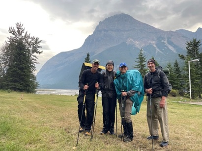
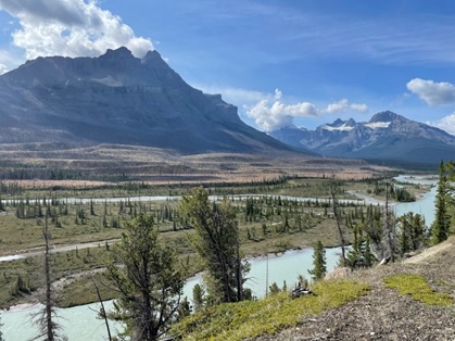
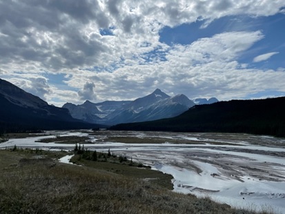
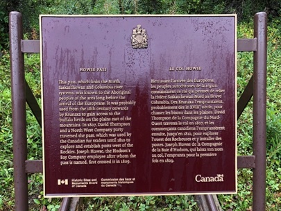
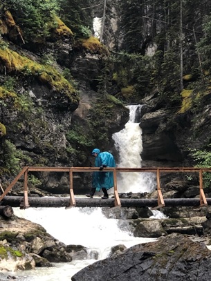
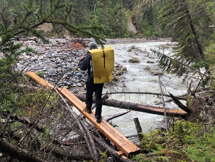
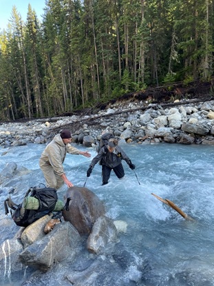
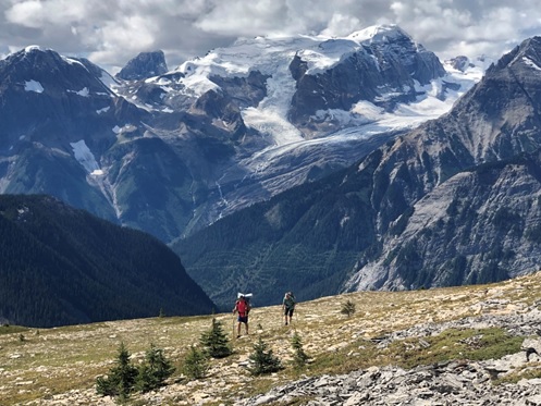
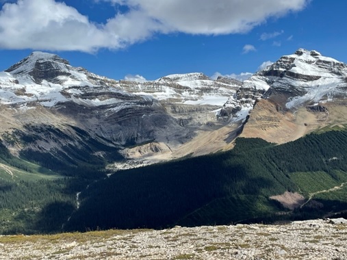
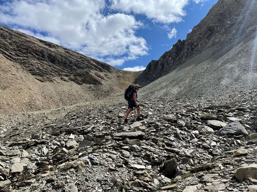
![Hiking up to Kiwetinok Pass [notice Kiwetinok Gap top right that we just came down!]](https://greatdividetrail.com/wp-content/uploads/2021/10/Section-D-11.jpg)