Author: bradvaillancourt

  • Holiday Gift Ideas from the GDTA

    Holiday Gift Ideas from the GDTA

    Here are a few winter holiday gift ideas that will be loved by any outdoor enthusiast – tickets to Brian Keating, a membership to the Great Divide Trail Association and the GDT App.  And all purchases will help support the outstanding work of the Great Divide Trail Association.  The GDTA is a not for profit, entirely volunteer organization that supports the maintenance, completion and protection of the Great Divide Trail.

    Thank you for your continued support. Wishing you a very Happy Holiday!

    briankeatingEvent Tickets – Join us for our 2018 fundraising event, an evening of stories with Brian Keating. Brian is a wildlife advocate, Canadian 2017 Outdoors Person of the Year and a regular on CBC Homestretch.

    Tickets are $15 for GDTA members and $30 for non-members and available through Eventbrite.


    IMG_3549GDTA Membership – A gift membership is great for anyone who might like to hike part or all of the trail, volunteer on a maintenance trip or support the completion and protection of the trail from the comfort of an armchair! Complete the on-line form for the recipient and in the “Please tell us more” box indicate that this is a gift membership and your address. We will post you a certificate to gift wrap.

    Individual $30, Couple $50 or Family $70


    GDT logo 2017GDT App – A GPS map-based hiking guide for use on smartphones and tablets. Great for anyone considering hiking all or sections of the trail.

    Each section of the GDT (A – G) is available for individual purchase: CAD$5.49 / USD$3.99 per section
    Or take advantage of the “thru-hiker discount” and purchase the entire trail for a 35% savings: CAD$24.99 / USD$17.99

  • Pathfinder Newsletter – Autumn 2017

    Pathfinder Newsletter – Autumn 2017

    Summer of 2017 one of the most successful and productive summer’s the GDTA has ever had! Despite the intensely dry and burning conditions in British Columbia and into Alberta, the GDT was busy as ever with more recorded thru-hikers on the trail this year than ever before. This Autumn edition of the Pathfinder Newsletter will provide a summary of our efforts including:

    • Trail maintenance and building trips
    • Trail Tales
    • Wildfire on the GDT
    • Backcountry kitchen
    • Annual General Meeting
    • New GDT Logo
    • And some well-deserved recognition!

    You can view the latest edition of Pathfinder here.

    Pathfinder-Fall 2017

  • Winter 2017/18 Trail and Road Conditions

    Winter 2017/18 Trail and Road Conditions

    Trail Conditions Update – November 13, 2017

    Winter is here. Snow has fallen on all of the GDT and is accumulating so expect wet, icy and slippery trail conditions. Heavy boots, snow cleats or snowshoes are recommended. Temperatures are below freezing, so be prepared for winter conditions and short days when travelling into the backcountry this winter.

    Remember that the GDT is not designed for snow travel and is not maintained in the winter. When the trail is covered in snow, finding it may be impossible so excellent navigation skills are required. Hiking on the GDT when it’s snow covered means exposing yourself to potential avalanche risk. In many places, it’s unwise to travel the trail during these conditions. While planning your hike, research snow conditions and check out the Canadian Avalanche Centre for the latest avalanche bulletins

    TRAIL CLOSURES:

    • Due to the Kenow wildfire, all trails and backcountry campgrounds in Waterton Lakes National Park and Akamina Kishinena Provincial Park remain closed. The GDT is closed from the International Boundary (a1) to Sage Pass (a17). No detour is available.
    • Due to the Verdant Creek Wildfire, the GDT is closed from Citadel Pass (c13) to Sunshine Meadows (c15). Detour around the closure by leaving the GDT at Watridge Lake trail junction (c7) and rejoin the GDT at Sunshine Village (c15). 
    • Jasper National Park seasonal closure – The GDT is closed from Four Point Campground (e15) to Signal Mountain Trailhead (e32) from November 1, 2017 to February 28, 2018, to prevent trails from facilitating an unnatural level of predator access to threatened woodland caribou.
    • Numa Creek Trail (Rockwall access trail) remains closed due to wash out of the bridge over the Vermilion River. 
    • Tumbling Creek Trail (Rockwall access trail) is closed from the Ochre Creek trail to the intersection of the Rockwall Trail before the Tumbling bridge due to a missing bridge at km 6.6.

    TRAIL NOTICES:

    • Approximately 35 km of the GDT was burned by the Kenow Wildfire between Bertha Bay campground and Font Creek (a19). We will have to wait until next summer to determine the full extent of the damage. Some trails that have been damaged by wildfire may require environmental analysis or heavier engineering, and closures could be in place for many months, for the health of the trail and the surrounding landscapes as well as the safety of hikers and volunteers. The GDTA will continue to monitor and assess the condition of these damaged trails and provide updates as they become available.
    • From Scarpe Pass (a24), the trail disappears so hikers must route-find up to La Coulotte Ridge, where the hiking becomes significantly more difficult until you reach the ATV track (a27) heading down to the West Castle Road. 
    • A large avalanche has destroyed about 200 m of trail north of Dutch Creek campground, near Tornado Pass (b16). Hikers should traverse the scar area around the down slope side so as to avoid climbing over unstable fallen trees.
    • Leroy Creek has washed out approximately 100m of the trail obscuring the location of the creek ford. Look for cairns on either side of the creek marking the crossing.
    • There is a new bridge over the Upper Elk Lake outflow (b38) and a new bypass trail to Fox Lake and West Elk Pass just before the bridge.
    • A windstorm blew through Yoho National Park in July 2017 resulting in many blown down trees – On the Ottertail Trail, there are several debris fields with fallen trees across the trail near Goodsir Pass (c36). On the Amiskwi Trail, about 1 km from the trailhead (d1), there are dozens of trees blow down across the trail.
    • Cairnes Creek (d9): The bridge is washed out making this a potentially dangerous ford. There are 2 large trees down across the creek allowing hikers to cross. If these trees wash away, it is recommended to ford the creek early in the morning when glacial melt is lowest.
    • The damaged Lambe Creek bridge (d10) was removed in September 2015. It is recommended to ford downstream where the creek is wider and shallower, and cross early in the morning when glacial melt is lowest.
    • The Howse Pass Trail from Conway Creek (d12) to the Glacier Lake trail junction (d14, 15 km) is in very poor condition. The trail is overgrown, with hundreds of wind-fallen trees across the trail. Hiking in the Howse River floodplain is recommended when the river is low enough to safely ford.
    • The Owen Creek Trail was cleared in July 2015 up to km 6 but there has been some new deadfall since then. Beyond that point, the trail is in poor shape with several washed out sections. Expect challenging hiking for 3 km including skirting along steep creek-side cliffs and rock-hopping in the creek itself. At km 6, do not take the trail heading up away from the creek (it is a deadend). Look for orange blazes marking the correct route staying near the creek.
    • The Maligne Pass trail in Jasper National Park has been decommissioned and is in poor shape. The trail from Pobokton Creek (e20) to Maligne Lake (e25, approx 42 km) is no longer being maintained by Parks Canada so expect deteriorating and overgrown trail conditions; long pants are recommended. The Maligne River bridge has been removed but the river can be easily forded in normal summer conditions (knee deep in mid-summer). Most other bridges are still in place. Read Nathan Dahl’s August 30, 2015 Maligne Pass trail update here. The Six Passes Route is a good alternative to the overgrown trail.
    • The Yates Torrent Bridge is out at the crossing of the Coleman Glacier outflow (near f16). Do not attempt to cross at the old bridge location. There are two options: (1) ford the Smoky River in the floodplain; or (2) ford Yates Torrent approximately 500m upstream (location was flagged in 2017). At both locations attempt to cross early in the morning when glacial melt is the lowest or be prepared for a fast and potentially dangerous creek ford.
    • The bridges across Gendarme and Carcajou Creeks are out on the Jasper North Boundary Trail. These two creeks are smaller than the Smoky River, but can still be treacherous. Cross Gendarme at the horse crossing just below the old bridge (marked), and Carcajou about 100m below the trail.
    • The bridge across Buchanan Creek on the trail to Kakwa Lake, has been removed. The crossing here can be hazardous early in the year or after heavy rains. 

    ACCESS ROADS:

    Winter conditions exist on many mountain highways and roads. Roads can be snowy and icy so check for the latest conditions before you travel and carry chains and/or winter tires. For more information, check out Alberta 511 and Drive BC.

    • Akamina Parkway and Red Rock Parkway in Waterton Lakes National Park are closed.
    • Highway 40 will be seasonally closed from Peter Lougheed Provincial Park to Highwood House beginning December 1.
    • Forestry Trunk Road 940 will be seasonally closed south of Cataract Creek and northwest of Plateau Mountain Road beginning December 1.


  • High Rock Trail – 2017

    High Rock Trail – 2017

    By Doug Borthwick

    This year, we increased our work on the High Rock Trail significantly, expanding to multiple scouting and trail building trips throughout the summer. A huge amount was accomplished thanks to the large number of hard-working and dedicated volunteers. Some of the key accomplishments in 2017:

    • 27 km of new route scouted and flagged
    • 5 km of new trail built or fine-tuned
    • Four bridge sites assessed, 2 bridges built
    • 45 volunteers participated in 8 separate scouting or trail building trips
    • 23 return volunteers from previous year’s trips
    • 22 first-time volunteers
    • An incredible sense of accomplishment achieved by all!

    June Scouting Trips – In June, our scouting crews covered a lot of ground by both quad and foot. They scouted and tested new access routes and assessed four bridge building sites. On foot they bushwhacked the same routes multiple times, sometimes on steep slopes with heavy brush on the lower elevations and almost thigh deep snow on the ridge tops. In the end they had mapped and flagged a 3 kilometre route for the 2017 trail crews. Eight additional kilometres were scouted and roughly flagged for future construction. At night the scouting volunteers rested their weary bodies around the warm campfire and discussed future planning. Even though the weather was often cold, windy and wet they always had a smile on their faces.

    On the road to camp
    On the road to camp

    July Trail Building Trips – The first crew arrived at Dutch Creek on July 16, after a long five hour drive from Calgary, the last hour and a half over a slow going rough and bumpy road. After setting up personal tents, the crew spent the next four hours unpacking and setting up a comfortable camp and sorting through the multiple tools needed for the three different crews over the next 12 days. This year’s camp included two large shelters with the one for the kitchen being totally enclosed. A sheltered latrine was built and an outdoor shower was set up. The solar heated shower was much appreciated and a very popular luxury that all three crews took advantage of. There was little time left in the day but the crew was anxious to get working. One group walked a 4 km access trail, bringing the tools they would need for the next day’s work and assessed what they would be doing. A separate chainsaw crew brought their power equipment and were given instructions on the blazing and type and size of corridor that needed to be cut and brushed.

    Setting up camp
    Setting up camp

    Day 2 saw the group again split in two. Both crews got specialty tool orientation and training after the daily safety tailgaters. One crew spent the morning clearing the trail to the location of a new bridge over a creek affectionately referred to as “Fred”. They then moved up to the new trail built last year to make some improvements. The second crew began the chainsaw and brushing work on a new section of trail. After 100 meters, the tread and finishing crew moved in and started the tread development on some steep side hill. Bodies and muscles were sore at the end of the day but all the team members were feeling a great sense of accomplishment.

    Building trail
    Building trail

    During the evening debriefing the crew got some scary news from some quadders that a small fire was smouldering in the forest less than a half kilometre away. Some of the crew joined the quadders and brought along buckets to attempt to extinguish it. After pouring 100 five gallon pails of water on, it was still showing signs of life. The team used the satellite phone to call it in to the nearby ranger station. It was determined by the professionals that there was not an immediate danger of it spreading as it was in a fairly wet area with a nearby creek flowing on both sides. Two days later a team of firefighters flew in to totally extinguish it. The investigation revealed that the fire was more than likely started by a lightning strike from about 5 days previous and had worked itself below ground.

    Lightning strike fire!
    Lightning strike fire!

    The final days of work saw the teams continue the clearing and building of new corridor and trail tread as well as helping the Alberta Parks crew put the sills in for the new Fred bridge.

    Bridge building
    Bridge building

    The evenings were spent relaxing and story telling under the canopy and the crew was given a session on tying knots by Wayne, resident knot-tying expert. They all came away with a new appreciation of this skill. The final half day didn’t allow much time for trail building so most of the crew spent the morning hiking the trail built by last year’s crew, while a few crew members spent the day clearing and building a tricky switchback.

    A happy trail crew
    A happy trail crew

    When the new crew arrived at noon, both crews got together for a barbecue and get to know each other session. Then it was time for the first crew to head home. This left plenty of time for the new volunteers to get out to the work areas and get their training, orientation and a start on their work projects. Seeing the amazing job the first crew had done, this group got right into it with the hopes their work could be as good. Work continued on the main new trail work as well as the Fred bridge site and improvements on the previous rough cut route done last fall for the next three days. Many on both the first two crews received some valued chainsaw training from an expert sawyer. Scott not only instructed them on safety, but proper cutting and falling techniques as well as explaining the saws working parts, use and care.

    Chainsaw training
    Chainsaw training

    During the day much knowledge of native plants and flowers was shared with the group by a crew member well studied in the field. It seemed like there was at least one outdoor plant expert on each of this year’s crews willing to share their knowledge and the other team members soaked it up. Back at camp each night, the crew members on this group were privileged to be in the company of three of the original GDT surveyors that had spent a full summer together in the early 1970’s scouting and laying down the original route. Their pictures and adventurous storytelling kept many of the team up way too late. This crew worked extremely hard during the day and at night bodies were sore. Luckily there was a yoga instructor among them and the nightly stretching sessions made getting out of bed the next morning an easier chore. This was a GDTA Signature Trip so all the food was supplied and meals planned. The well thought out meals were amazing, fresh, nutritious and plentiful. The cooks worked extremely hard preparing and managing this task as well as working side by side with the other crew members on the trail all day. Their energy and upbeat tempo inspired others on the crew.

    Original GDTA'ers Dave, Jenny and Lani
    Original GDTA’ers Dave, Jenny and Lani

    On changeover day, the crew again split up with about half venturing out for a stroll on the 8 km of new finished and rough cut trail to see the totality of what had been done to date. Others found a great fishing spot on the creek and were given fly fishing tips. A half a dozen trout were caught and released.

    Fishing in the creek
    Fishing in the creek

    At noon the final crew arrived from Calgary and another barbecue ensued. The boundless energy of the old crew seemed to rub off on the last team. After the second crew left, the new team headed out to their respective work sites to receive their instructions and get started. The new team was amazed at the quality of work done and how impressive the new trail looked. With new energy and enthusiasm they got their own projects underway.

    The GDTA Trail Crew in The North Face jackets
    The GDTA Trail Crew in The North Face jackets

    This group split into four crews, one started construction of the new bridge at the Dutch Creek / North Fork Pass junction, one to finish the tread work and put the finishing touches on the new section the other crews had cut through, one to finish tread work on rough cut 2016 trail, and the last were finishing a kilometre of trail that had just had the chainsaw crew go through.

    GDTA Trail Crew
    GDTA Trail Crew

    All the crews worked through the hottest weather for the next four days, and they were all very thankful for Lani who remained at camp, filtering fresh water for them all day.

    Camp water, filtered by Lani
    Camp water, filtered by Lani

    At the end of the day, the teams met back at camp and were treated to fantastic meals organized and put together by Jocelyn, who had also spent her days digging new tread and trimming the overgrowth on the new trail before preparing the scrumptious feasts.

    Photo 2017-07-25
    Camp kitchen

    During the downtime at camp there were tons of activities taking place. One adventurous group spied a pool in the creek large enough to fully immerse themselves. Their screams were reportedly heard all the way across the BC border when they realized how ice cold the water was. For others relaxing in a lawn chair with a cold beverage was enough excitement after a long day with a Pulaski. There was creativity shown by this group also as one night, a number of them got together and Shannon taught them how to make dream weavers out of willow branches and other natural material from the area. They had a fine time as their merriment was heard well into the night. The time finally came to break camp. The last day was spent cleaning the campsite, breaking down equipment and packing it away. When they left you could hardly tell that 45 people had camped there for 12 days.

    Relaxing at camp
    Relaxing at camp

    One of the most fulfilling things on these trips was seeing how the team members who had never experienced trail building changed over the course of 3 or 4 days. At the start some were timid and could hardly swing a rogue hoe let alone a Pulaski or axe. By the time each team had ended their stay, everyone had become competent and confident trail builders. They all took great pride in their work and really enjoyed the transformation of wild forest to finely groomed trail tread.

    GDTA Trail Crews
    GDTA Trail Crews

    August Bridge Build – The new “Fred” bridge was originally planned to be completed by the July crews. Unfortunately there was an equipment breakdown and helicoptering in the big span logs was delayed until the last work day for the crews. The sill work had been completed, the spans were set and all the boards and attaching hardware left at the site. All that was left to do was build the decking and railing. Two volunteers, Doug and Rick, were sent out over a long weekend to see if they could finish the bridge. Things got complicated a bit as an ATV ban for the area had just been put into place. Getting heavy tools and gear to the bridge site was the issue. Doug and Rick were able to fit everything in a wheelbarrow and backpacks and slowly worked the load up an old quad trail 3 km to the bridge site. Once at the site they proceeded to decipher the engineering plans and put the decking in place.

    IMG_0142

    The next day the posts and rails were cut to size and installed. There was a little trial and error involved and some of the installed pieces had to be disassembled and reinstalled for a better overall fit and finish. About halfway through on the second day the power supply’s ran out of juice and left Doug and Rick at a standstill. This meant they had to pack the rechargeable batteries all the way back to camp and use the generator to recharge them. It took nearly four hours to charge all of the batteries and it was late in the afternoon already. Not knowing how much more they would need the power drill, Doug and Rick walked back to the bridge site and worked late to get as much done as possible. The last day took them only a couple of hours to get the bridge complete and clean up the site. At the end of the day there was a lot of pride taken in the finished product. A great backcountry bridge that is second to none in strength and durability built with the help of Alberta Environment and Parks.

    Fred bridge
    Fred bridge

    September Scouting Trip – It was a last second scramble to get prepared and meet at Chinook Lake near Coleman for the four volunteers in this trip, as a month long backcountry ban had just been lifted. The notice was short but they all arrived on time. On the first day, Dave, Brad and Peter scouted and flagged a 16 km route from Window Mountain Lake down to Chinook Lake. They were thrilled by the great views of the Crowsnest Pass area as the trail is going to be mostly above treeline here. During this same time, Doug scrambled up to Window Mountain Lake to do some exploring. Window Mountain Lake is a high mountain cirque that will most assuredly be a highlight on the future trail.

    The next day they started southward from where the finished section of this year’s trail work ended. The day saw wet snow falling as they ascended the ridge and marked out 5 km of new trail. They were cold and wet at camp but were warmed by a propane fire back at camp. The last day was most memorable as fresh snow on the ground allowed them to see the plentiful tracks of a wolf pack as they followed 2 km up the ATV access route. Another thrill was the well defined and rather large grizzly prints as they re-entered the new trail corridor to do the final mapping. The snow had stopped but they were just as wet and cold at the end of the day from all the bushwhacking. That night around the fire a sense of satisfaction was felt as they now had flagged 5 km of new trail ready to be built next summer. See you all out there in 2018!

    Thank you! – Thanks go out to all of our hard-working volunteers who built or mapped the trail this year, and all the special people who spent countless hours over the winter months getting official authorizations, planning and making sure these trips go as smoothly as they do. Well done!

    Special thanks to our sponsors and partners: Alberta Environment and Parks, MEC, Teck, The North Face, and Stihl. Their generous donations and support were a huge part of our successful trail work in 2017.

     
  • Wildfires on the Great Divide in 2017

    Wildfires on the Great Divide in 2017

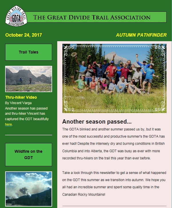
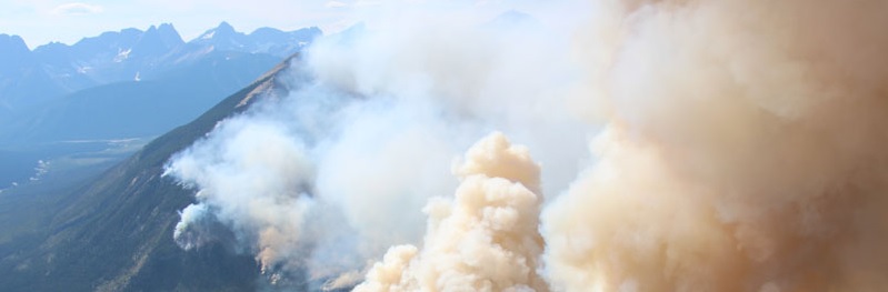
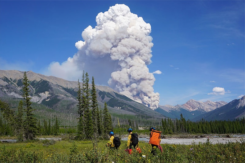
    It was a hot and dry summer in the Canadian Rockies, and fire hazard conditions along the Great Divide were extremely high for most of the hiking season. Due to these extreme conditions, the summer of 2017 was one of the worst wildfire seasons on record in Western Canada and some of the larger wildfires burned so deeply that they may continue to smoulder underground over the winter (a frightening thought!).

    Due to the dozens of wildfires burning, thick smoke, poor air quality and reduced visibility were common this year along the Great Divide. There were two wildfires in particular that caused significant closures and damage to the GDT: The Verdant Creek Wildfire and the Kenow Wildfire.

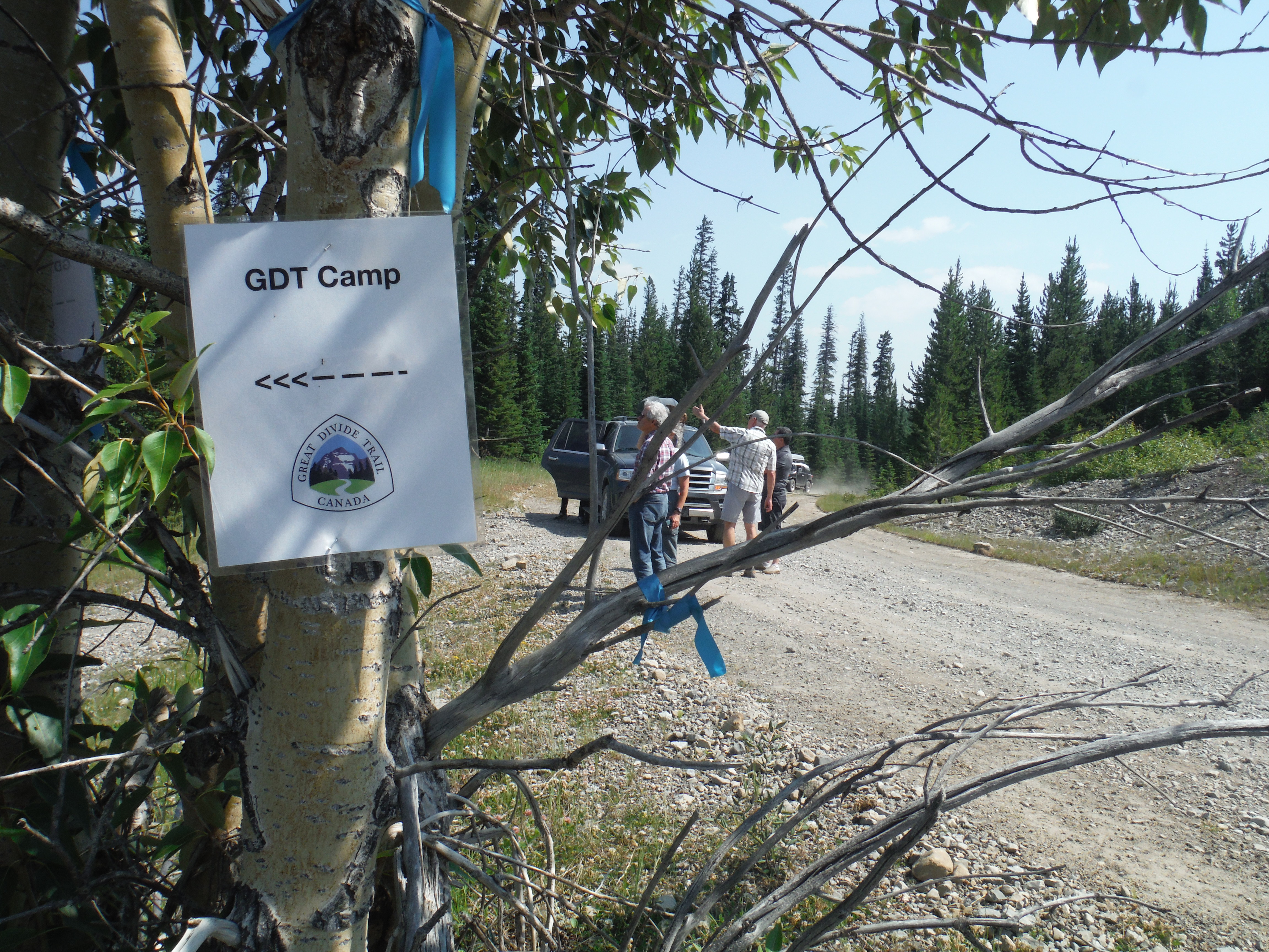
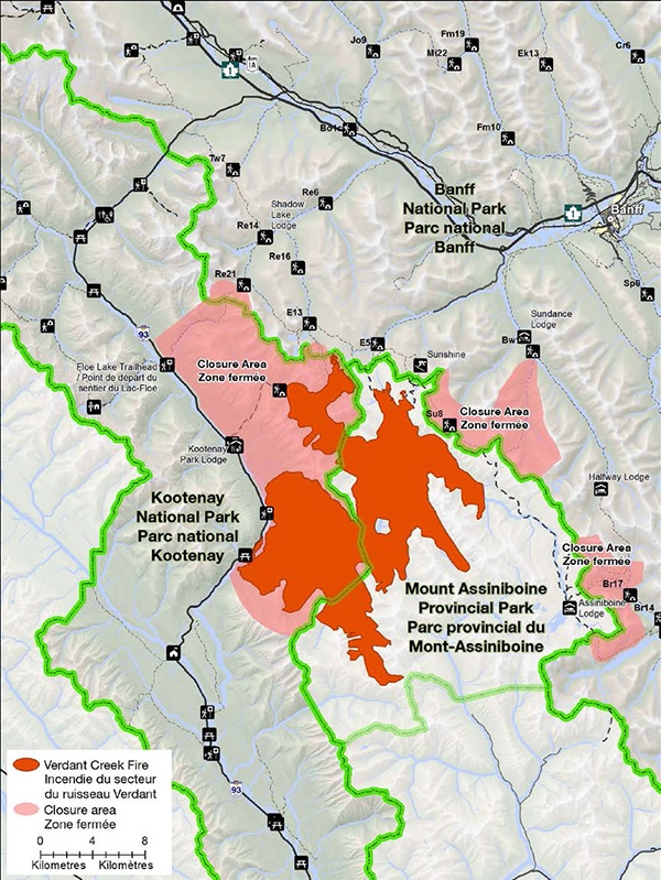
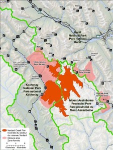
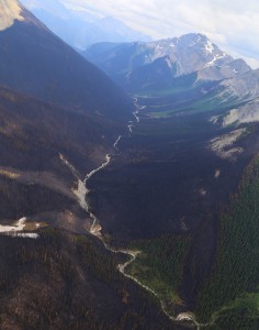
    The Verdant Creek Wildfire was started by lightning strikes in the Verdant Creek valley on July 13 or 14, and burned 15,500 hectares of wilderness in Kootenay National Park and Mount Assiniboine Provincial Park. 69 kilometres of the GDT from Wonder Pass to Hawk Creek trailhead were closed in August and September, and the GDT remains closed in Banff National Park from Citadel Pass to Sunshine Meadows. None of the GDT was actually burned by the Verdant Creek Wildfire.

    verdant1

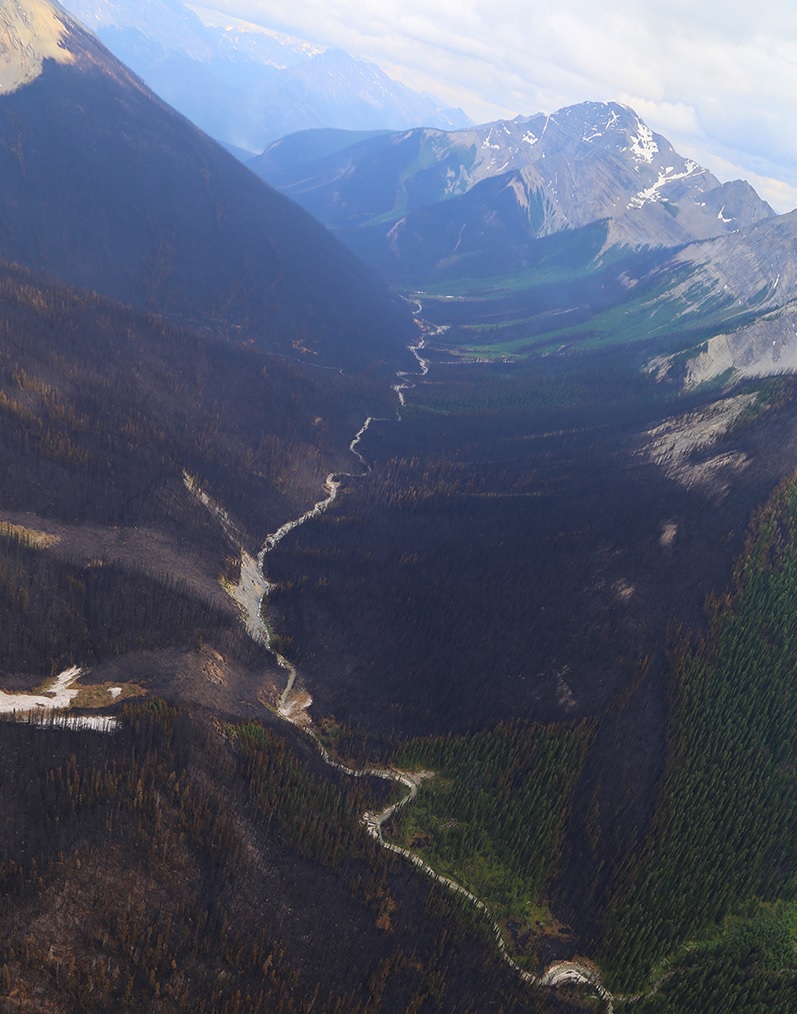
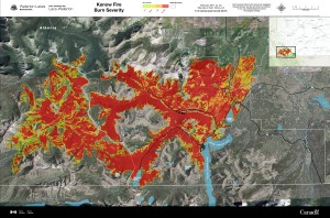
    The Kenow Wildfire was started by lightning strikes in the Flathead Valley in southeast BC on August 30, and burned 35,000 hectares of wilderness, including significant portions of Waterton Lakes National Park and Akamina-Kishinena Provincial Park. 71.5 kilometres of the GDT from the International Boundary to La Coulotte Peak were closed in August and September, and the GDT remains closed in Waterton Lakes National Park. Approximately 30 km of the GDT was burned by the Kenow Wildfire. This amounts to more than 50% of the GDT within Waterton Lakes National Park.

    Kenow Wildfire

    Verdant Creek Wildfire

    The Verdant Creek Wildfire was ignited by lightning on July 13 or 14 in Kootenay National Park. Due to hot and dry conditions in a remote location, the fire spread quickly. Parks Canada immediately closed a large section of backcountry in Kootenay and Banff National Parks which included the GDT from Citadel Pass to Ball Pass Junction. Similarly, the eastern portion of Mount Assiniboine Provincial Park was closed, including the GDT from Og Lake to Citadel Pass.

    On July 16, strong winds intensified the wildfire and it spread quickly into Mount Assiniboine Provincial Park. 85 fire crew personnel, 40 pilots, 35 support staff were brought in to fight the wildfire. A significant amount of smoke was produced by the wildfire, filling the Bow and Columbia valleys, resulting in poor air quality advisories as far away as Calgary.verdant4

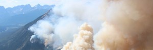
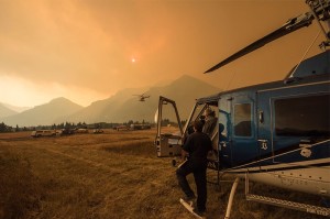
    On July 21, Sunshine Village was closed and evacuated to allow the site to be used as a staging area for fire crews battling the wildfire that had advanced to within 2.5 km of Sunshine Village. Over the next several days, with favourable weather conditions, fire crews made good progress to prevent the spread of the wildfire and hold its growth. On July 24, Sunshine Village re-opened and on July 26, trails in the Egypt Lake area, Healy Pass and Sunshine Meadows re-opened.

    But on July 30, the weather turned for the worst. Hotter, dryer and high winds resulted in increased wildfire activity and brought the fire right up to the Great Divide and down to Highway 93. The highway was closed and fire crews worked hard to stop the spread of the fire and protect park facilities. Huge smoke columns were produced, and smoke filled the mountain valleys again, resulting in more air quality advisories. Trails in Egypt Lake area, Healy Pass and Sunshine Meadows were again closed, and Sunshine Village was again closed and used as a staging area for fire crews. All of Mount Assiniboine Provincial Park was closed.

    verdant3By August 5, the wildfire had spread down to Highway 93, with embers igniting several spot fires on the west side of the highway. Parks Canada closed further sections of the GDT, including the Hawk Creek Trail and the Rockwall Trail.

    As the fire continued to spread, on August 8, the Vermilion Pass Guard containment line was re-established to create a fuel break and reduce wildfire spread to the Bow Valley. Helicopters continued to bucket hot spots while ground crews worked directly on the fire’s edge to contain the spread of the fire.

    A shift in wind direction on August 9 permitted fire crews to carry out direct fire suppression work on the northern side of the fire using air and ground crews, and on August 10 Sunshine Village and some surrounding trails were re-opened to the public, and Highway 93 was re-opened. Conditions continued to improve and on August 20, all trails in the Egypt Lake area, Healy Pass and Sunshine Meadows re-opened.

    Over the next few weeks, fire crews continued to make good progress to contain the remaining sections of the wildfire burning in remote areas of Kootenay National Park and Mount Assiniboine Provincial Park. On September 14, after cooler temperatures and some rain, the Verdant Creek Wildfire was considered being held.

    verdant2The Verdant Creek Wildfire burned mainly in remote areas of Kootenay National Park and Mount Assiniboine Provincial Park. It did not cross the Great Divide and fortunately did not impact any local communities, buildings or facilities within the parks. The GDT was also spared from damage but the trail from Citadel Pass to Sunshine Meadows remains closed.

    Kenow Wildfire

    The Kenow Wildfire was started by lightning strikes on August 30 on the slopes above Kishinena Creek in British Columbia’s Flathead Valley. Due to a period of unusually hot weather and high winds, the fire grew quickly and by September 2 it had expanded east 7 kilometres towards the Alberta border to a size of 4,500 hectares.

    On September 4, the fire crossed the Divide and spot fires began igniting in Waterton Lakes National Park. Parks Canada closed all trails and campgrounds in the western portion of the park, including the Great Divide Trail. A national incident management team arrived on site in the National Park, along with three initial attack crews and five helicopters. The fire management team assessed containment options, and crews began working on facility protection. Additional fire management resources were requested.

    kenow4On September 6, Parks Canada issued an evacuation alert for all of Waterton Lakes National Park as the Kenow Wildfire continued to expand. As temperatures cooled overnight, smoke settled in the valley bottoms and Environment Canada issued a special air quality warning for the area due to significant wildfire smoke affecting air quality and visibility. Weather forecasts predicted hotter and windier weather conditions later that week which would increase the potential danger or hazards from the wildfire. Fire crews continued to battle the fire and protect facilities using water pumps and sprinklers throughout the park and Waterton townsite.

    By September 8, the fire had grown to 7,800 hectares in size and an evacuation order was issued for Waterton Lakes National Park and Waterton Lakes National Park and Akamina-Kishinena Provincial Park were closed. By end of day, Parks Canada and RCMP had safely evacuated all residents and non-essential personnel from the park. Helicopters continued to work to reduce wildfire spread at Sage and South Kootenay passes by bucketing water. Fire crews removed vegetation from South Kootenay Pass and strengthened natural and human-made landscape features in the Akamina and Red Rock valleys to stop or slow the spread of the wildfire.

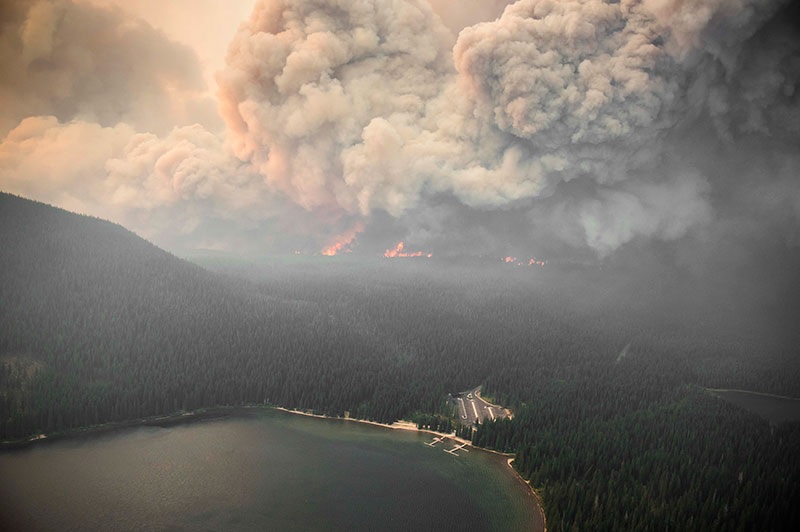
    But weather conditions took a turn for the worse on September 10 when temperatures soared, humidity dropped, and high winds picked up. The Kenow Wildfire began demonstrating intense fire behaviour, burning quickly through 11.5 km of the Akamina Valley, growing to more than 10,000 hectares in size. Helicopters continued to bucket water, foam and retardant on spot fires along the Divide and crews conducted aerial ignitions in the Akamina Valley to attempt to steer the fire and reduce the potential of additional spreading. Intense fire behaviour, high winds and smoke severely reduced visibility and hampered fire suppression activities.

    kenow3Additional crews were brought in, increasing resources to 185 personnel, 14 helicopters, 9 air tankers, 17 fire engines, and 16 specialized structural and wildland fire crews. A National Incident Management team set up high volume pumps, hoses and sprinklers to create a protective perimeter around the Waterton townsite and several other buildings in the area.

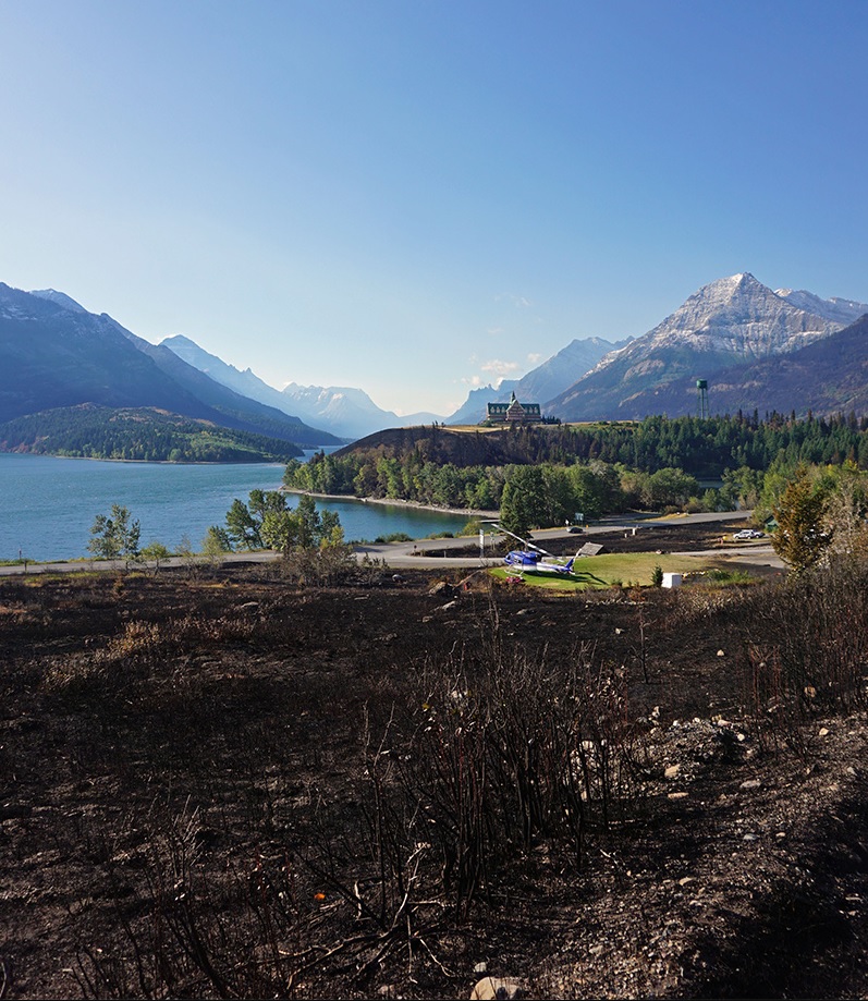
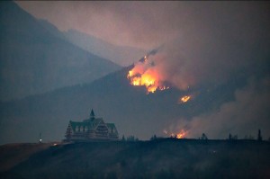
    On the afternoon of September 11, the Kenow Wildfire crossed into Alberta over Akamina Pass and began demonstrating extreme fire behaviour for many hours due to high winds and critically dry vegetation. Over the next 8 hours, the wildfire would almost quadruple in size, growing to more than 35,000 hectares. Wind gusts up to 100 km/hour caused intensified burning and the fire moved very quickly northeast down the Cameron Valley along the Akamina Parkway towards the Waterton townsite. In the evening, fire became visible from the townsite and then on the north side of Crandell Mountain, soon surrounding the townsite on all sides except the lake. Firefighters worked tirelessly throughout the night to protect homes and facilities. Dedicated fire crews, high volume pumps and sprinkler systems, ensured the townsite perimeter held and the majority of infrastructure and facilities within the community were saved. Elsewhere, some buildings and infrastructure were lost to the fire.

    kenow5That night, the wildfire began to move north at a high rate of spread through the grasslands along the park’s Entrance Road towards neighbouring municipalities outside of the park. As the fire spread beyond the park’s boundary, mandatory evacuation notices were issued at 10:15pm for parts of the Municipal District of Pincher Creek, Cardston County and the Blood Reserve. Many residents were left scrambling to get out, unaware of how quickly the fire was spreading. Everyone was safely evacuated, but five homes were lost in the fire.

    Also that night, the wildfire moved upslope from Sage Pass and crossed the Great Divide into the Castle drainage area. While the fire didn’t spread very far into the Castle area, several kilometres of the GDT were burned.

    Over the next few days, cooler temperatures, higher humidity, lighter winds and rainfall provided some relief and reduced the wildfire’s behaviour. Ground and air fire crews continued to work to suppress and contain the fire, which continued to burn in some areas for several more days (and may continue to smoulder underground for much longer). On September 19, the Kenow Wildfire was considered being held, the evacuation order was lifted, roads re-opened, and residents were able to return to their homes.

    kenow2While some of the park has re-opened to the public, the GDT remains closed throughout Waterton Lakes National Park and the future of the trail in that park remains uncertain.

    Life after wildfire

    It is important to remember that wildfire is a natural process in the wilderness. Almost immediately after a fire, many wildlife species including birds, mammals and insects are often seen in burned areas. Fire opens up the forest canopy and allows more sunlight to reach understory plants, increasing productivity and biodiversity. Fire recycles nutrients stored in live and dead vegetation by converting it into mineral-rich ash. After a fire, pine cones pop open from fire’s heat, releasing their seeds; new growth sprouts from the roots of burned shrubs; flowers bloom and grasslands are reborn; and animals forage in the lush new growth. Over time, fires create a patchwork of burned and unburned vegetation. This diverse mix of habitats is favoured by wildlife and supports many species.

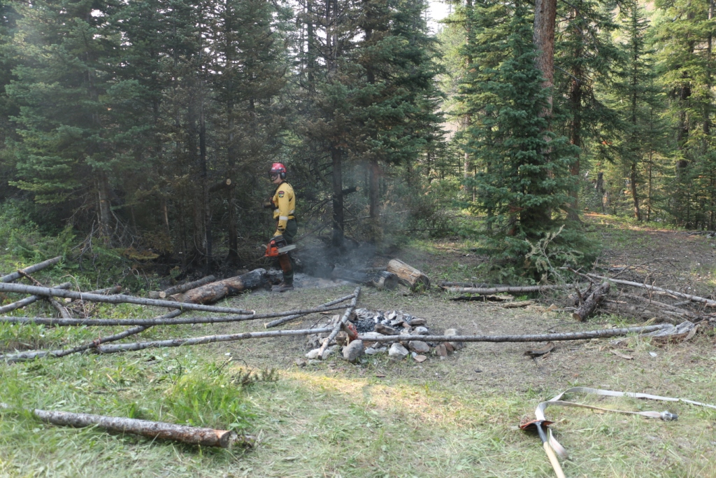
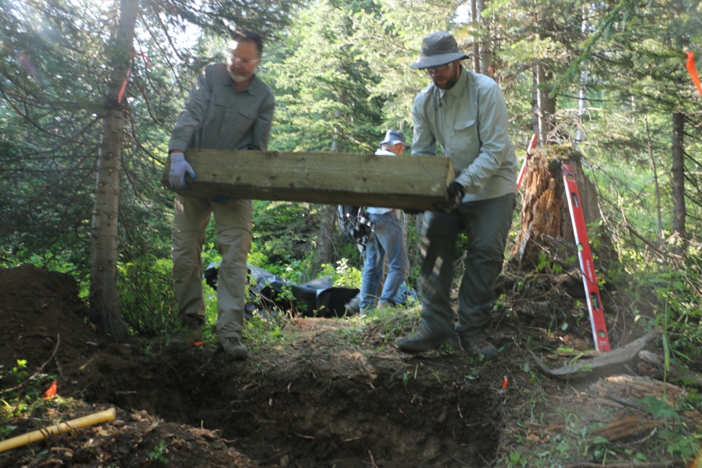
    For hikers and volunteers anxious to hike or help repair fire-damaged trails, patience is required. Even after fires are considered out, there can still be hazards: saturated soils, landslides, roots and stumps that continue to smoulder, falling trees, and burnt out bridges. We will have to wait until next summer to determine the full extent of the damage. Some trails that have been damaged by wildfire may require environmental analysis or heavier engineering, and closures could be in place for many months, for the health of the trail and the surrounding landscapes as well as the safety of hikers and volunteers. The GDTA will continue to monitor and assess the condition of these damaged trails and provide updates as they become available.

  • October 2017 Trail and Road Conditions

    October 2017 Trail and Road Conditions

    Trail Conditions Update – October 23, 2017

    Fall colours are here, and so is the snow! Snow has fallen on most of the GDT and is accumulating at higher elevations. Expect snow above 1500 metres with wet, icy and slippery trail conditions, and wet and muddy sections at lower elevations with recent rainfall or snow melt. Heavy boots or cleats are recommended. Nighttime and early morning temperatures are below freezing, so be prepared for cold temperatures and shorter days when travelling into the backcountry this fall.

    TRAIL CLOSURES:

    • Due to the Kenow wildfire, all trails and backcountry campgrounds in Waterton Lakes National Park and Akamina Kishinena Provincial Park remain closed. The GDT is closed from the International Boundary (a1) to Sage Pass (a17). No detour is available.
    • Due to the Verdant Creek Wildfire, the GDT is closed from Citadel Pass (c13) to Sunshine Meadows (c15). Detour around the closure by leaving the GDT at Watridge Lake trail junction (c7) and rejoin the GDT at Sunshine Village (c15). 
    • The GDT will be closed from Four Point Campground (e15) to Signal Mountain Trailhead (e32) from November 1, 2017 to February 28, 2018, to prevent trails from facilitating an unnatural level of predator access to threatened woodland caribou.
    • Numa Creek Trail (Rockwall access trail) remains closed due to wash out of the bridge over the Vermilion River. 
    • Tumbling Creek Trail (Rockwall access trail) is closed from the Ochre Creek trail to the intersection of the Rockwall Trail before the Tumbling bridge due to a missing bridge at km 6.6.

    ELK RUTTING SEASON WARNING: It is elk rutting season. Warning signs that read “ATTENTION – Elk Mating” have been posted at areas where elk herds often gather. Be aware that bull elk become extremely aggressive during rutting season so keep at least 30 metres away from all elk and never get between a male and female elk.

    BEARS:  It’s pre-hibernation feeding season for both black and grizzly bears which increases the chances of running into a bear on the trail. It is easy to surprise a bear that is focussed on feeding so make noise while hiking in bear territory. Carry bear spray, watch for fresh bear signs, and if you see a bear, back away slowly and leave the area. Never run.

    TRAIL NOTICES:

    • From Scarpe Pass (a24), the trail disappears so hikers must route-find up to La Coulotte Ridge, where the hiking becomes significantly more difficult until you reach the ATV track (a27) heading down to the West Castle Road. 
    • A large avalanche has destroyed about 200 m of trail north of Dutch Creek campground, near Tornado Pass (b16). Hikers should traverse the scar area around the down slope side so as to avoid climbing over unstable fallen trees.
    • Leroy Creek has washed out approximately 100m of the trail obscuring the location of the creek ford. Look for cairns on either side of the creek marking the crossing.
    • There is a new bridge over the Upper Elk Lake outflow (b38) and a new bypass trail to Fox Lake and West Elk Pass just before the bridge.
    • A windstorm blew through Yoho National Park in July 2017 resulting in many blown down trees – On the Ottertail Trail, there are several debris fields with fallen trees across the trail near Goodsir Pass (c36). On the Amiskwi Trail, about 1 km from the trailhead (d1), there are dozens of trees blow down across the trail.
    • Cairnes Creek (d9): The bridge is washed out making this a potentially dangerous ford. There are 2 large trees down across the creek allowing hikers to cross. If these trees wash away, it is recommended to ford the creek early in the morning when glacial melt is lowest.
    • The damaged Lambe Creek bridge (d10) was removed in September 2015. It is recommended to ford the creek downstream.
    • The Howse Pass Trail from Conway Creek (d12) to the Glacier Lake trail junction (d14, 15 km) is in very poor condition. The trail is overgrown, with hundreds of wind-fallen trees across the trail. Hiking in the Howse River floodplain is a viable alternative if the Howse River is low enough to ford.
    • The Owen Creek Trail was cleared in July 2015 up to km 6 but there has been some new deadfall since then. Beyond that point, the trail is in poor shape with several washed out sections. Expect challenging hiking for 3 km including skirting along steep creek-side cliffs and rock-hopping in the creek itself. At km 6, do not take the trail heading up away from the creek (it is a deadend). Look for orange blazes marking the correct route staying near the creek.
    • The Maligne Pass trail in Jasper National Park has been decommissioned and is in poor shape. The trail from Pobokton Creek (e20) to Maligne Lake (e25, approx 42 km) is no longer being maintained by Parks Canada so expect deteriorating and overgrown trail conditions; long pants are recommended. The Maligne River bridge has been removed but the river can be easily forded in normal summer conditions (knee deep in mid-summer). Most other bridges are still in place. Read Nathan Dahl’s August 30, 2015 Maligne Pass trail update here. The Six Passes Route is a good alternative to the overgrown trail.
    • The Yates Torrent Bridge is out at the crossing of the Coleman Glacier outflow (near f16). Do not attempt to cross at the old bridge location. Instead, ford the Smoky River farther down the valley. Attempt to cross early in the morning when glacial melt is the lowest or be prepared for a fast and potentially dangerous creek ford.
    • The bridges across Gendarme and Carcajou Creeks are out on the Jasper North Boundary Trail. These two creeks are smaller than the Smoky River, but can still be treacherous. Cross Gendarme at the horse crossing just below the old bridge (marked), and Carcajou about 100m below the trail.
    • The bridge across Buchanan Creek on the trail to Kakwa Lake, has been removed. The crossing here can be hazardous early in the year or after heavy rains. 

    ACCESS ROADS:

    • Access to the northern terminus of the GDT in Kakwa Provincial Park is via the Walker Creek Forest Service Road. The Walker Creek FSR is uneven, rutted, slippery and rough, so 4WD/AWD high clearance vehicle is recommended. The last 10km from Bastille Creek to Buchanan Creek is closed due to washouts and is not driveable by vehicle so be prepared to walk this distance on foot.
  • September 2017 Trail and Road Conditions

    September 2017 Trail and Road Conditions

    Trail Conditions Update – September 26, 2017

    Cool, wet autumn weather has arrived in the Rockies. Expect fresh snowfall above 1700 metres and wet and muddy trail conditions. Be prepared for colder temperatures and shorter days when travelling on the trail this fall.

    WILDFIRES: With the recent wet and cool weather, fire danger ratings in the Canadian Rockies have improved considerably, but some trail closures and campfire bans are still in effect due to ongoing wildfire management. 

    TRAIL CLOSURES:

    • Due to the Kenow wildfire, all trails and backcountry campgrounds in Waterton Lakes National Park and Akamina Kishinena Provincial Park remain closed. The GDT is closed from the International Boundary (a1) to La Coulotte Ridge (a27). No detour is available at this time.
    • Mount Assiniboine Provincial Park, Banff National Park and Kootenay National Park have partial closures due to the Verdant Creek Wildfire. The GDT is closed from Og Lake (c11) to Sunshine Meadows (c15). Detour around the closure by leaving the GDT at Watridge Lake trail junction (c7) and rejoin the GDT at Sunshine Village (c15). 
    • Trail 7 near Jasper is closed to hikers south of the junction with Trail 7e and north of the junction with Trail 7a due to grizzly and black bears frequenting the area next to the golf course. Detour by taking Trail 7e towards Trefoil Lakes and Trail 7b south to Old Fort Point trailhead. Equestrian uses can still use Trail 7 but are not to dismount.
    • Numa Creek Trail (Rockwall access trail) remains closed due to wash out of the bridge over the Vermilion River. 
    • Tumbling Creek Trail (Rockwall access trail) is closed from the Ochre Creek trail to the intersection of the Rockwall Trail before the Tumbling bridge due to a missing bridge at km 6.6.

    CAMPFIRE BANS

    • A Fire Restriction and campfire ban is still in effect for Zones 1-3 of the Calgary Forest Area which includes all sections of the GDT in Alberta from Sage Pass (a17) to Beehive Natural Area (b24), inclusive. Where the GDT is still open, gas or propane stoves are still allowed in campgrounds.
    • For current information, check out Alberta Fire Bans or BC Wildfire Status websites.

    ELK RUTTING SEASON WARNING: It is elk rutting season until mid-October. Warning signs that read “ATTENTION – Elk Mating” have been posted at areas where elk herds often gather. Be aware that bull elk become extremely aggressive during rutting season so keep at least 30 metres away from all elk and never get between a male and female elk.

    BEARS:  It’s pre-hibernation feeding season for both black and grizzly bears which increases the chances of running into a bear on the trail. It is easy to surprise a bear that is focussed on feeding so make noise while hiking in bear territory. Carry bear spray, watch for fresh bear signs, and if you see a bear, back away slowly and leave the area. Never run.

    TRAIL NOTICES:

    • From Scarpe Pass (a24), the trail disappears up to La Coulotte Ridge and the hiking becomes significantly more difficult until you reach the ATV track (a27) heading down to the West Castle Road.
    • A large avalanche has destroyed about 200 m of trail north of Dutch Creek campground, near Tornado Pass (b16). Hikers should traverse the scar area around the down slope side so as to avoid climbing over unstable fallen trees.
    • There is a new bridge over the Upper Elk Lake outflow (b38) and a new bypass trail to Fox Lake and West Elk Pass just before the bridge.
    • To protect sensitive habitat and improve habitat security for grizzly bears, hiking or travel anywhere except on official trails or designated roads in the Sunshine Meadows, Citadel Pass, and Healy Pass areas of Banff National Park is prohibited. 
    • A windstorm blew through Yoho National Park in July resulting in many blown down trees – On the Ottertail Trail, there are several debris fields with fallen trees across the trail near Goodsir Pass (c36). On the Amiskwi Trail, about 1 km from the trailhead (d1), there are dozens of trees blow down across the trail.
    • Cairnes Creek (d9): The bridge is washed out making this a potentially dangerous ford. There are 2 large trees down across the creek allowing hikers to cross with dry feet. If these trees wash away, it is recommended to ford the creek early in the morning when glacial melt is lowest.
    • The damaged Lambe Creek bridge (d10) was removed in September 2015. It is recommended to ford the creek downstream.
    • The Howse Pass Trail from Conway Creek (d12) to the Glacier Lake trail junction (d14, 15 km) is in very poor condition. The trail is overgrown, with hundreds of wind-fallen trees across the trail. Hiking in the Howse River floodplain is a viable alternative if the Howse River is low enough to ford.
    • The Owen Creek Trail was cleared in July 2015 up to km 6. Beyond that point, the trail is in poor shape with several washed out sections. Expect challenging hiking for 3 km including skirting along steep creek-side cliffs and rock-hopping in the creek itself. At km 6, do not take the trail heading up away from the creek (it is a deadend). Look for orange blazes marking the correct route staying near the creek.
    • The Maligne Pass trail in Jasper National Park has been decommissioned and is in poor shape. The trail from Pobokton Creek (e20) to Maligne Lake (e25, approx 42 km) is no longer being maintained by Parks Canada so expect deteriorating and overgrown trail conditions; long pants are recommended. The Maligne River bridge has been removed but the river can be easily forded in normal summer conditions (knee deep in mid-summer). Most other bridges are still in place. Read Nathan Dahl’s August 30, 2015 Maligne Pass trail update here. The Six Passes Route is a good alternative to the overgrown trail.
    • The Yates Torrent Bridge is out at the crossing of the Coleman Glacier outflow (near f16). Do not attempt to cross at the old bridge location. Instead, ford the Smoky River farther down the valley. Attempt to cross early in the morning when glacial melt is the lowest or be prepared for a fast and potentially dangerous creek ford.
    • The bridges across Gendarme and Carcajou Creeks are out on the Jasper North Boundary Trail. These two creeks are smaller than the Smoky River, but can still be treacherous. Cross Gendarme at the horse crossing just below the old bridge (marked), and Carcajou about 100m below the trail.
    • The bridge across Buchanan Creek on the trail to Kakwa Lake, has been removed. The crossing here can be hazardous early in the year or after heavy rains. 

    ACCESS ROADS:

    • Access to the northern terminus of the GDT in Kakwa Provincial Park is via the Walker Creek Forest Service Road. The Walker Creek FSR is uneven, rutted, slippery and rough, so 4WD/AWD high clearance vehicle is recommended. The last 10km from Bastille Creek to Buchanan Creek is closed due to washouts and is not driveable by vehicle so be prepared to walk this distance on foot.
  • August 2017 Trail and Road Conditions

    August 2017 Trail and Road Conditions

    Trail Conditions Update – August 22, 2017

    WILDFIRES: Fire danger ratings in the Rockies are very high and trail closures and campfire bans are in effect. Wildfire smoke is occurring along much of the GDT and is causing poor air quality and reduced visibility. Read wildfire updates regularly and be cautious out there.

    • SECTION A TRAIL CLOSURES: Due to extreme fire hazard in Waterton Lake National Park, the GDT is closed from Rowe Meadow (a10) to the Blakiston Valley trail junction, and the Sage Pass Trail is also closed (a16 to a17). No detour is available at this time.
    • SECTION A CAMPGROUND CLOSURES: All backcountry campgrounds in Waterton Lake National Park and Akamina Kishinena Provincial Park are closed due to extreme fire hazard.
    • SECTION C TRAIL CLOSURES: Mount Assiniboine Provincial Park, Banff National Park and Kootenay National Park have partial closures due to the due to the Verdant Creek Wildfire. The GDT is closed from Og Lake (c11) to Citadel Pass (c13), and from Ball Pass Junction (c21) to Hawk Creek trailhead (c23). Detour around these closures is difficult but can be done by leaving the GDT at Watridge Lake trail junction (c7) or Allenby Pass junction (on the Assiniboine Pass alternate) and rejoin the GDT at the Floe Lake trailhead (c23). The GDT is open around Sunshine Village and Egypt Lake but cannot be hiked contiguously due to the closures north and south of Sunshine Village.

    CAMPFIRE BANS: Given the extremely high fire hazard, campfires are not recommended anywhere on the GDT until further notice. 

    • A campfire ban is in effect in all of BC, which includes all sections of the GDT in BC from Akamina Pass to Kakwa Lake. These prohibitions do not apply to cooking stoves that use gas or propane.
    • Due to the high fire hazard, backcountry and front country campfire bans are in effect in Banff, Jasper, Kootenay, Waterton Lakes and Yoho National Parks.
    • A Fire Restriction and campfire ban has been issued for the Calgary Forest Area which includes all sections of the GDT in Alberta from Sage Pass to North Kananaskis Pass, due to high fire hazard. Gas or propane stoves are still allowed in campgrounds and random camping areas.
    • For current information, check out Alberta Fire Bans or BC Wildfire Status websites.

    BEARS:  It’s berry season! Berry bushes border trails, roads and campgrounds on the GDT, and black and grizzly bears are feeding on berries right now. Be bear aware on the trails this summer, make noise and carry bear spray.

    TRAIL CLOSURES:

    • Waterton Lakes National Park: Rowe Lake Trail is closed due to grizzly bears feeding in the area.
    • Due to extreme fire hazard in Waterton Lake National Park, the GDT is closed from Rowe Meadow (a10) to the Blakiston Valley trail junction, and the Sage Pass Trail is also closed (a16 to a17). No detour is available at this time.
    • All backcountry campgrounds in Waterton Lake National Park and Akamina Kishinena Provincial Park are closed due to extreme fire hazard.
    • Mount Assiniboine Provincial Park, Banff National Park and Kootenay National Park have partial closures due to the due to the Verdant Creek Wildfire. The GDT is closed from Og Lake (c11) to Citadel Pass (c13), and from Ball Pass Junction (c21) to Hawk Creek trailhead (c23). Detour around these closures is difficult but can be done by leaving the GDT at Watridge Lake trail junction (c7) or Allenby Pass junction (on the Assiniboine Pass alternate) and rejoin the GDT at the Floe Lake trailhead (c23). The GDT is open around Sunshine Village and Egypt Lake but cannot be hiked contiguously due to the closures north and south of Sunshine Village.
    • Trail 7 near Jasper is closed to hikers south of the junction with Trail 7e and north of the junction with Trail 7a due to grizzly and black bears frequenting the area next to the golf course. Detour by taking Trail 7e towards Trefoil Lakes and Trail 7b south to Old Fort Point trailhead. Equestrian uses can still use Trail 7 but are not to dismount.
    • Numa Creek Trail (Rockwall access trail) remains closed due to wash out of the bridge over the Vermilion River. 
    • Tumbling Creek Trail (Rockwall access trail) is closed from the Ochre Creek trail to the intersection of the Rockwall Trail before the Tumbling bridge due to a missing bridge at km 6.6.

    TRAIL NOTICES:

    • From Scarpe Pass (a24), the trail disappears up to La Coulotte Ridge and the hiking becomes significantly more difficult until you reach the ATV track (a27) heading down to the West Castle Road.
    • There is a new bridge over the Upper Elk Lake outflow (b38) and a new bypass trail to Fox Lake and West Elk Pass just before the bridge.
    • To protect sensitive habitat and improve habitat security for grizzly bears, hiking or travel anywhere except on official trails or designated roads in the Sunshine Meadows, Citadel Pass, and Healy Pass areas of Banff National Park is prohibited. 
    • Cairnes Creek (d9): The bridge is washed out making this a potentially dangerous ford. There are 2 large trees down across the creek allowing hikers to cross with dry feet. If these trees wash away, it is recommended to ford the creek early in the morning when glacial melt is lowest.
    • The damaged Lambe Creek bridge (d10) was removed in September 2015. It is recommended to ford the creek downstream.
    • The Howse Pass Trail from Conway Creek (d12) to the Glacier Lake trail junction (d14, 15 km) is in very poor condition. The trail is overgrown, with hundreds of wind-fallen trees across the trail. Hiking in the Howse River floodplain is a viable alternative if the Howse River is low enough to ford.
    • The Owen Creek Trail was cleared in July 2015 up to km 6. Beyond that point, the trail is in poor shape with several washed out sections. Expect challenging hiking for 3 km including skirting along steep creek-side cliffs and rock-hopping in the creek itself. At km 6, do not take the trail heading up away from the creek (it is a deadend). Look for orange blazes marking the correct route staying near the creek.
    • The Maligne Pass trail in Jasper National Park has been decommissioned and is in poor shape. The trail from Pobokton Creek (e20) to Maligne Lake (e25, approx 42 km) is no longer being maintained by Parks Canada so expect deteriorating and overgrown trail conditions; long pants are recommended. The Maligne River bridge has been removed but the river can be easily forded in normal summer conditions (knee deep in mid-summer). Most other bridges are still in place. Read Nathan Dahl’s August 30, 2015 Maligne Pass trail update here. The Six Passes Route is a good alternative to the overgrown trail.
    • The Yates Torrent Bridge is out at the crossing of the Coleman Glacier outflow (near f16). Do not attempt to cross at the old bridge location. Instead, ford the Smoky River farther down the valley. Attempt to cross early in the morning when glacial melt is the lowest or be prepared for a fast and potentially dangerous creek ford.
    • The bridges across Gendarme and Carcajou Creeks are out on the Jasper North Boundary Trail. These two creeks are smaller than the Smoky River, but can still be treacherous. Cross Gendarme at the horse crossing just below the old bridge (marked), and Carcajou about 100m below the trail.
    • The bridge across Buchanan Creek on the trail to Kakwa Lake, has been removed. The crossing here can be hazardous early in the year or after heavy rains. 

    ACCESS ROADS:

    • Due to extreme fire hazard, recreational use of off-road vehicles is prohibited on all Crown lands in southwest BC and southeast Alberta.
    • A travel advisory is in effect for Highway 93 South from Castle Junction to Radium. Fire fighters will be working adjacent to the highway and reduced speed zones will be in place. Drivers should anticipate possible delays.
    • Access to the northern terminus of the GDT in Kakwa Provincial Park is via the Walker Creek Forest Service Road. The Walker Creek FSR has been repaired from Highway 16 to km 33.5. While travelling the remaining 40 kilometres on the Walker Creek FSR, attention is required to navigate the surface as it is uneven, rutted, slippery and very rough. 4WD/AWD high clearance vehicle is recommended. The last 10km from Bastille Creek to Buchanan Creek is closed due to washouts and is not driveable by vehicle so be prepared to walk this distance on foot.
  • Pathfinder Newsletter – Summer 2017

    Pathfinder Newsletter – Summer 2017

    Canada is celebrating its 150th year and the GDTA is celebrating another trail building season in the Canadian Rocky Mountains! The arrival of summer also brings the beginning of the 2017 hiking season on the Great Divide Trail. Determined thru-hikers are already beginning their adventures South to North (and back again) as the weather warms, snow melts and wildflowers bloom. Check out the latest edition of the Pathfinder Newsletter to learn more about adventuring on the Great Divide Trail and the work of the GDTA, including:

    • Trail Tales
    • 2017 Trail Maintenance Trips
    • Skill Building
    • Sponsor Spotlight
    • Trail & Road ConditionsUpcoming Events

    You can view the latest edition of Pathfinder here.

    pathfinder-summer

  • July 2017 Trail and Road Conditions

    July 2017 Trail and Road Conditions

    Trail Conditions Update – July 29, 2017

    Summer is in full swing on the Great Divide which means alpine wildflowers are blooming and wildfires are burning in some areas.

    Trails are mostly bare and dry, with some snow patches at higher elevations. Warm weather means rapid snow and ice melt during the day resulting in high water levels and potentially dangerous creek crossings, so attempt to ford larger creeks early in the day when water levels are lowest.

    WILDFIRES: Fire danger ratings in the Rockies are very high and trail closures and campfire bans are in effect. Wildfire smoke is occurring along much of the GDT and is causing poor air quality and reduced visibility. Read wildfire updates regularly and be cautious out there.

    • TRAIL CLOSURE: Banff National Park, Kootenay National Park and Mount Assiniboine Provincial Park all have trail closures due to the due to the Verdant Creek Wildfire. The GDT is closed from Og Lake campground (c11) to Sunshine Meadows. Detour around the closure by leaving the GDT at Watridge Lake trail junction (c7) or Allenby Pass trail junction on the Assinibone Pass alternate route (noting that access is restricted to groups of 4 or more on the Allenby Pass Trail). Hikers can return to the GDT at Sunshine Village (c15). Sunshine Village is open.
    • A campfire ban is in effect in all of BC, which includes all sections of the GDT in BC from Akamina Pass to Kakwa Lake. These prohibitions do not apply to cooking stoves that use gas or propane.
    • Due to the high fire hazard, backcountry and front country campfire bans are in effect in Banff, Jasper, Kootenay, Waterton Lakes and Yoho National Parks.
    • A Fire Restriction and campfire ban has been issued for the Calgary Forest Area which includes all sections of the GDT in Alberta from Sage Pass to North Kananaskis Pass, due to high fire hazard. Gas or propane stoves are still allowed in campgrounds and random camping areas.
    • Given the extremely high fire hazard, campfires are not recommended anywhere on the GDT until further notice. 
    • For current information, check out Alberta Fire Bans or BC Wildfire Status websites.

    BEARS:  Berry bushes border trails, roads and campgrounds on the GDT, and black and grizzly bears are feeding on berries right now. Be bear aware on the trails this summer, make noise and carry bear spray.

    • Jasper National Park – Bears are frequenting the area around the Signal Fire Road on the north end of the Skyline Trail, so be extra cautious when travelling in that area, make noise and carry bear spray.

    TRAIL CLOSURES:

    • Banff National Park, Kootenay National Park and Mount Assiniboine Provincial Park all have trail closures due to the due to the Verdant Creek Wildfire. The GDT is closed from Og Lake campground (c11) to Sunshine Meadows. Detour around the closure by leaving the GDT at Watridge Lake trail junction (c7) or Allenby Pass trail junction on the Assinibone Pass alternate route (noting that access is restricted to groups of 4 or more on the Allenby Pass Trail). Hikers can return to the GDT at Sunshine Village (c15). Sunshine Village is open.
    • Trail 7 near Jasper is closed to hikers south of the junction with Trail 7e and north of the junction with Trail 7a due to grizzly and black bears frequenting the area next to the golf course. Detour by taking Trail 7e towards Trefoil Lakes and Trail 7b south to Old Fort Point trailhead. Equestrian uses can still use Trail 7 but are not to dismount.
    • Numa Creek Trail (Rockwall access trail) remains closed due to wash out of the bridge over the Vermilion River. 
    • Tumbling Creek Trail (Rockwall access trail) is closed from the Ochre Creek trail to the intersection of the Rockwall Trail before the Tumbling bridge due to a missing bridge at km 6.6.

    TRAIL NOTICES:

    • From Scarpe Pass (a24), the trail disappears up to La Coulotte Ridge and the hiking becomes significantly more difficult until you reach the ATV track (a27) heading down to the West Castle Road.
    • There is a new bridge over the Upper Elk Lake outflow (b38) and a new bypass trail to Fox Lake and West Elk Pass just before the bridge.
    • To protect sensitive habitat and improve habitat security for grizzly bears, hiking or travel anywhere except on official trails or designated roads in the Sunshine Meadows, Citadel Pass, and Healy Pass areas of Banff National Park is prohibited. 
    • The Rockwall Trail is still experiencing early season conditions and is recommended for experienced backpackers only who are prepared for hiking through a variety of hazards and obstacles including snow over steep slopes over Tumbling Pass (c30), avalanche debris across the trail in various locations and fording Helmet Creek by heading upstream from the bridge location (the creek is just above knee deep – bring a rope for a safer crossing).
    • Cairnes Creek (d9): The bridge is washed out making this a potentially dangerous ford. There are 2 large trees down across the creek allowing hikers to cross with dry feet. If these trees wash away, it is recommended to ford the creek early in the morning when glacial melt is lowest.
    • The damaged Lambe Creek bridge (d10) was removed in September 2015. It is recommended to ford the creek downstream.
    • The Howse Pass Trail from Conway Creek (d12) to the Glacier Lake trail junction (d14, 15 km) is in very poor condition. The trail is overgrown, with hundreds of wind-fallen trees across the trail. Hiking in the Howse River floodplain is a viable alternative if the Howse River is low enough to ford.
    • The Owen Creek Trail was cleared in July 2015 up to km 6. Beyond that point, the trail is in poor shape with several washed out sections. Expect challenging hiking for 3 km including skirting along steep creek-side cliffs and rock-hopping in the creek itself. At km 6, do not take the trail heading up away from the creek (it is a deadend). Look for orange blazes marking the correct route staying near the creek.
    • The Maligne Pass trail in Jasper National Park has been decommissioned and is in poor shape. The trail from Pobokton Creek (e20) to Maligne Lake (e25, approx 42 km) is no longer being maintained by Parks Canada so expect deteriorating and overgrown trail conditions; long pants are recommended. The Maligne River bridge has been removed but the river can be easily forded in normal summer conditions (knee deep in mid-summer). Most other bridges are still in place. Read Nathan Dahl’s August 30, 2015 Maligne Pass trail update here. The Six Passes Route is a good alternative to the overgrown trail.
    • The Yates Torrent Bridge is out at the crossing of the Coleman Glacier outflow (near f16). Do not attempt to cross at the old bridge location. Instead, ford the Smoky River farther down the valley. Attempt to cross early in the morning when glacial melt is the lowest or be prepared for a fast and potentially dangerous creek ford.
    • The bridges across Gendarme and Carcajou Creeks are out on the Jasper North Boundary Trail. These two creeks are smaller than the Smoky River, but can still be treacherous. Cross Gendarme at the horse crossing just below the old bridge (marked), and Carcajou about 100m below the trail.
    • The bridge across Buchanan Creek on the trail to Kakwa Lake, has been removed. The crossing here can be hazardous early in the year or after heavy rains. 

    ACCESS ROADS:

    • Akamina Parkway is open.
    • Access to the northern terminus of the GDT in Kakwa Provincial Park is via the Walker Creek Forest Service Road. The Walker Creek FSR has been repaired from Highway 16 to km 33.5. While travelling the remaining 40 kilometres on the Walker Creek FSR, attention is required to navigate the surface as it is uneven, rutted, slippery and very rough. 4WD/AWD high clearance vehicle is recommended. The last 10km from Bastille Creek to Buchanan Creek is closed due to washouts and is not driveable by vehicle so be prepared to walk this distance on foot.