Each year we recognize the efforts of our volunteers who have gone above and beyond to help us achieve our objectives. This year has been an exceptional year for us on many fronts, and as a result we want to recognize the efforts of these 8 individuals whose hard work and dedication were a big part of our success in 2020:
Jim and Annette Schieck – In recognition of their important contributions to the 2020 GDTA Trail Building Trips. Jim and Annette participated in multiple trail building crews this past year. Whatever job they chose, latrine, water, fire pit etc. they did with great enthusiasm. Jim and Annette were very helpful to others and willing to go above and beyond. Jim’s work as a biologist enabled us to get a bird survey done so that work on Hail Ridge could be completed this summer. Both their knowledge of White Bark pine came in particularly handy on the heavily populated south slope so that we were able to keep our trail work from damaging any of this endangered species.
Dave Higgins – In recognition of his leadership and important contributions to the 2020 GDTA Trail Building, Maintenance and Bridge Building Trips. Dave led multiple trail building, trail maintenance and bridge building trips this year. In fact, Dave built not one but two much needed temporary bridges over Cairnes Creek. Dave has been the main person responsible for the rebuild of the David Thompson Heritage Trail and is leading the charge to get a permanent bridge built over Cairnes Creek.
Peter Labastide– In recognition of his leadership and important contributions to the 2020 GDTA Trail Building and Scouting Trips. Peter assisted multiple trail building trips this year. Peter was a major part of the organization of all crews and logistics. Peter took on the role of secretary of the Trail Building and Maintenance Committee (TBMC) very well and has been the lead for budgeting and procurement for the TBMC. He is always available for cleaning and organizing the tools and equipment.
Jud Virtue – In recognition of his leadership and important contributions to the 2020 GDTA Trail Building Trips. Jud was a first time trip leader this year and co-led multiple trips. Without Jud’s volunteering to lead a last minute trip on Section E, we may not have been able to do enough to open the High Rock Trail this summer.
Dan Durston – In recognition of his leadership and important contributions to Improve the Great Divide Trail and Support the GDT Hikers Community. Dan was a trip co-leader this year. He has been the driving force behind the improvements to notorious Section D resulting in a much more desirable hiking experience. Dan has been extremely helpful in planning and giving assistance to any and all aspiring thru hikers. He has made enormous contributions to the GDT community and continued improvements to the trail.
Dave Hockey – In recognition of your leadership and important contributions to 2020 GDTA Trail Building and Scouting Trips and Protecting and Advocating for the Great Divide Trail. Dave was the main person responsible for procuring some major grant money in a year that we thought all grant money was going to dry up. Dave was a leader on the TBMC and trip leader for multiple trips. Dave was the main person responsible for tools and supply storage and procurement for the TBMC. Dave’s incredible work was key to getting the High Rock Trail completed and opened this year despite exceptionally challenging circumstances.
Kathy Plachta – In recognition of her dedication and important contributions to GDTA Membership, Financial Reporting, Outreach and so much more! Kathy has done a superb job in managing GDTA membership and keeping GDTA finances in order over the years. Kathy has served the GDTA faithfully behind the scenes for numerous years and has been integral in maintaining and strengthening the financial health of this organization. In her positions as Treasurer and Co-Treasurer, she was responsible for keeping the books, budgeting, providing financial updates to the Board, updating corporate returns, preparing year-end statements, and administering membership renewals and donations. All of this was done efficiently and to a high standard. Thanks to her work, the GDTA is in an enviable position of being in great financial shape to weather the “COVID-19 storm”.
2020 was another great year for trail building and maintenance on the Great Divide Trail. Much thanks has to be given to all those on the GDTA Trail Building and Maintenance Committee(TMBC) who put in an extraordinary amount of work behind the scenes just to be able to safely put together any trips. Planning was ahead of schedule and most of the planned work trips were full by February. Then the country went into lockdown to protect citizens from a worldwide pandemic. It was at this point that all planning was put on hold and work trips were cancelled. There was a suggestion that all work parties for 2020 should remain cancelled. The TBMC worked diligently to come up with a plan to safely have at least a few work parties to get a minimal amount of work and maintenance done. After many hours of planning and strategizing they came up with a plan that would work to enable small groups to at least be able to do a little work on the GDT. In the end, what these small work groups accomplished was amazing. All told there were seven planned, advertised trips and two more unadvertised trips. A total of 57volunteers participated with many helping out on multiple work crews.
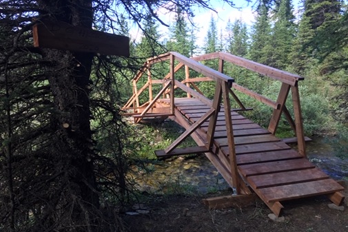
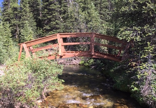
David Thompson Heritage Trail Trip – Cairnes and Lambe Creek Bridges:
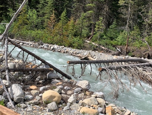
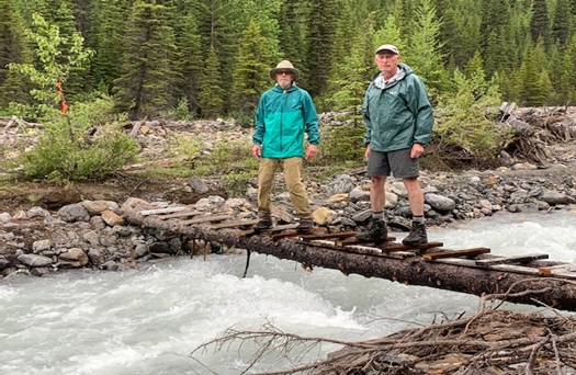
It started in late June when a small unit of three volunteers gathered at Cairnes Creek. The goal was to put a temporary bridge across Cairnes Creek (the double log crossing that had sufficed for the last four years had broken over the winter), re–scout the first km of the David Thompson Heritage Trail (which still has flooding problems),perform a minor repair, and strengthen the new hand rail on the Lambe Creek bridge.
The first day the crew cut the old logs and used some reclaimed lumber to make a stable crossing.
Unfortunately two weeks later the creek flooded again and washed this temporary bridge away.
The second day saw the crew make their way eight km up to Lambe Creek to reinforce the handrail on the LambeCreek bridge. Along the way they encountered many winter downed trees across the trail which had to be cut out. They spent a few hours at LambeCreek performing a small repair to the rail and reinforcing it with the two by fours which they had carried in by hand.
On the walk back the crew took notes of the flooded sections still occurring in the first km for future trips.
High Rock Trail – Trip #1
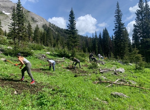
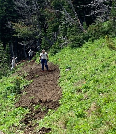
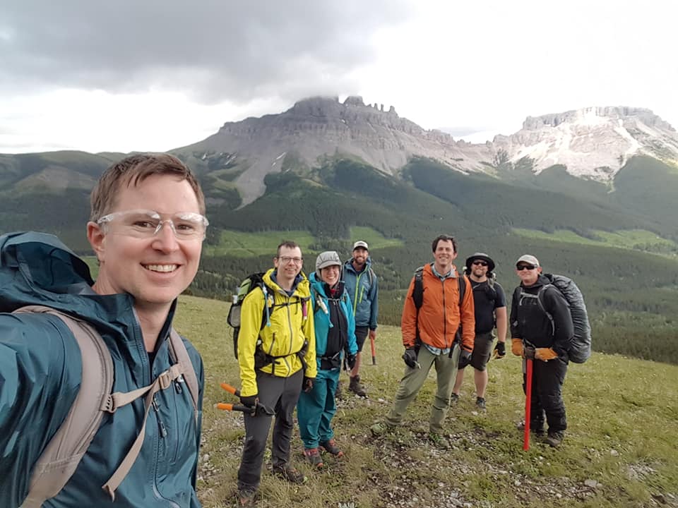
The GDTA official trips started June 24 with a volunteer crew of eight plus another crew of eight from the Outdoor Council of Canada. To safely have this large group, two separate camps had to be set up. Work on section L of the High Rock Trail (HRT) was started with hopes that at the end of four work crews, 700 meters of new tread would be built. This was all that had been cleared with chainsaws previously, and without a bird survey the crews could not chainsaw further up the ridge. Luck would have it that in the Trip #1 crew there was a biologist who would be able to survey the trail all the way to the ridge top. Now a chainsaw crew was able to further clear the rest of the route. What Trip #1 crew lacked in experience, they more than made up for with great enthusiasm, and when the smoke cleared they had built an incredible 1.1 km of new trail.
High Rock Trail – Trip #2
Trip #2 started with wet, miserable weather that would continue the whole five days. This crew dealt with some of the most consistent wet, muddy conditions ever experienced building the HRT. As well, they ran into some major endangered WhitebarkPine stands for which tread had to be gently built around. Trip #2’s tough crew of six built out another incredible 400 meters of new trail.
High Rock Trail – Trip #3
The conditions were not looking too promising for the Trip #3 crew either, as they had to contend with continuing rain for the first day and a half. Thankfully it soon cleared up and became sunny and pleasant for the remainder of their work party. The conditions were better but the terrain proved extremely rough with steep sidehill and lots of roots and rocks to contend with. This very experienced crew built some of the smoothest nicest tread ever, and by the end of their time they had hacked out another 400 meters of new trail.
High Rock Trail – Trips #4, #5, and #6
Trips #4, #5, and #6 were the last scheduled ones for the HRT for 2020, and they mostly ran concurrently. Trip #4 was camped just 1 km off the Atlas Road in section U, and with the help of a crew of Junior Forest Rangers for a day,they were able to finish tread on section U and V, and with the help of the HRT Walking Crew built a set of tricky switchbacks on section W. As well, they built a bridge over a small creek in section U. All in all another fantastic 1 km of tread was completed by this amazing mostly rookie crew.
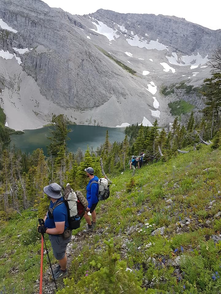
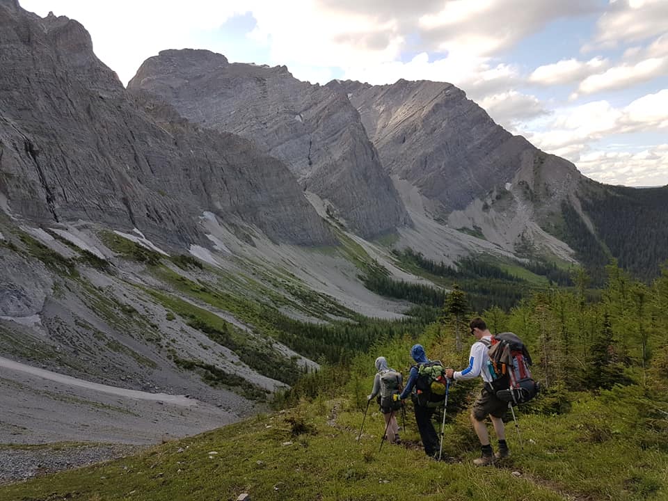
Trip #5’screw remained camped at the start of section L, and the first day had a really tough 100 meters to complete on a super steep exposed side slope. This was slow tedious work. The second day things got a little easier through a fairly flat forest, and then they broke onto Hail Ridge which was easy – mostly just scratching out a route. Meanwhile a small chainsaw crew had worked down the other side of the ridge into some new regenerated forest. This was two days of really rough chainsaw and brusher work to get a path worked through these close growing small trees.
During the evening of the third night the Trip #6 Walking Crew wandered into Trip #5’s camp. The previous three days for them had been spent marking and mapping trail from the southern start at Allison Creek. Along the way they had built tread, met up and helped Trip #4 crew build switchbacks on section W, and cleared and marked the trail allthe way. This young enthusiastic crew of former GDT thru hikers worked two more days marking and clearing the rest of the High Rock Trail route so that there would be a possibility of making it walkable soon.
Large deadfall cleared by hand
Meanwhile Trip #5 had crossed the ridge, and by utilizing an old horse packers trail,they were making rapid progress to the end of Section J. The last day saw them work into the regenerated forest area where the forward chainsaw crew was still hacking away. All in all, this incredible crew had built another 1.2 km of trail. They did this with the help of an easy ridge and horse packers trail in the middle.
So the High Rock Trips were supposedly done, resulting in an incredible 4 km of new tread built, as well as being completely cleared, marked, and mapped.
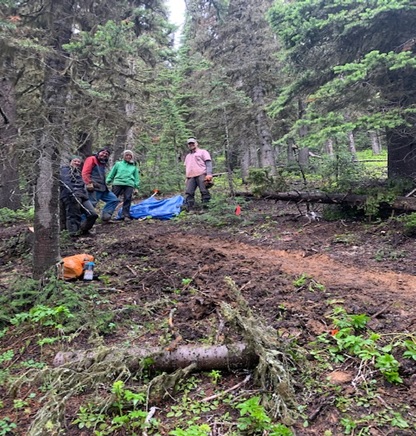
Lost Creek Trip
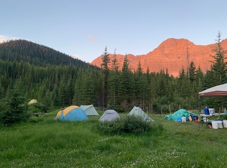
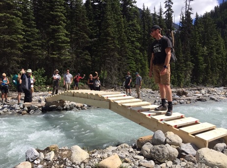
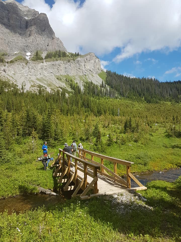
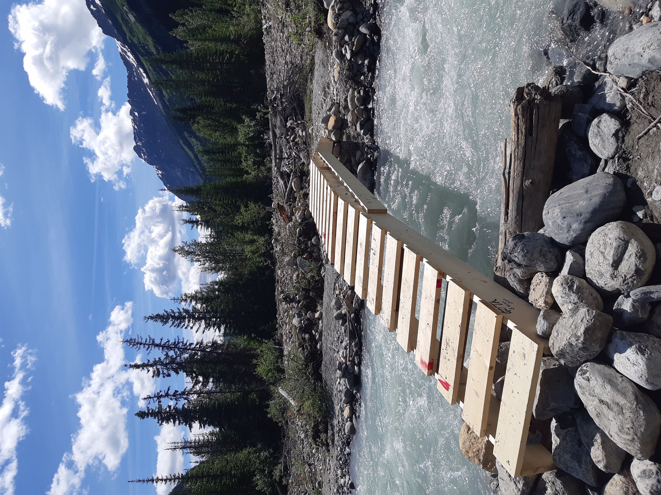
Late July saw the largest GDTA contingent of twelve working in two teams at Lost Creek. Team #1 worked to complete work started last year rebuilding the tread on the Lost Creek Trail. Team #2 was tasked with building a new bridge over Lost Creek. The weather cooperated and both teams completed their tasks to extremely high standards.
New Lost Creek bridge
High Rock Trail – Trip #7
When the Walking Crew’s report came in, it was felt that the entire HRT was “almost Walkable”. The only really tricky part was a 1 km section at the top of Section E which was deemed too hard to follow. A decision was made to see if it was possible to get a last minute volunteer crew put together to take care of the impassible kilometer. The call went out and five veterans and one rookie answered.
The newly made up High Rock crew was designated as Trip #7, and included five fairly experienced trail builders and one rookie. They worked during the hottest period of the summer. This enthusiastic crew right away had some decision making as the marked trail was confusing. Working on some difficult side slope off the bat, they had to contend with stacking some switchbacks where none looked possible. Slowly, for the first three days they built the new tread. Each day had a bonus as GDT thru hikers started passing them, showing that the High Rock Trail was being utilized.The last day was the most difficult terrain as it hadn’t been properly cleared or brushed. Building good tread on this last bit would normally take a fairly large crew one full trip. The issue was that this was the critical area that hikers could not follow unless there was some sort of a path. Digging deep, the five remaining trail builders determined they could at least make something followable and semi-walkable. What they accomplished was an extraordinary, very walkable path.Another 1 km of tread had been built and on July 24, the new High Rock Trail officially opened for business!
Sunset on the GDTA basecamp
Cairnes Creek Bridge Trip (yes, again…)
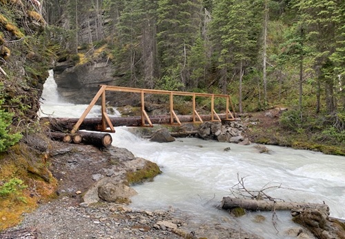
Meanwhile an informal crew of six or so had come together mid July to cobble together another temporary crossing of troublesome Cairnes Creek, so that this year’s hikers might have a safe crossing.
New temporary Cairnes Creek bridge
Late Season Scouting Trips
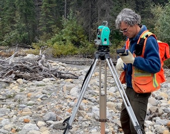
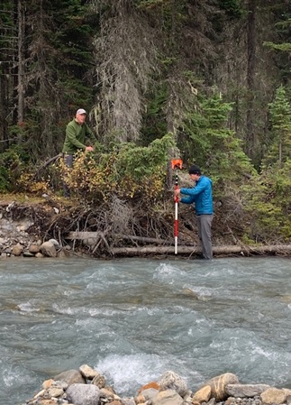
This should have been the end of the story except that there was still work to do so that preparations could be made for work in 2021. In mid September, a small crew got together again at Cairnes Creek to survey for a new permanent bridge, come up with solutions to mitigate future flooding on the first 1 km of the DTHT, and survey the new possible future route across Amiskwi Ridge and Collie Creek on the eastside of the Blaeberry River.
Surveying for a new bridge over Cairnes Creek
Additionally, scouting has taken place in early October for next year’s work on the HRT sections M,N, and O. Lots to look forward to!
Thank you to all
Many thanks to all of this year’s trail building crews, as well as the people behind the scenes putting everything together.
Thanks also go out to our sponsors and partnerswhose generosity has greatly enhanced our trail building and maintenance capabilities – They include Alberta Equestrian Federation, Alberta Environment and Park, BC Rec Sites and Trails, The North Face, MEC, Teck, Stihl, and Columbia Basin Trust.
By Brad Vaillancourt, President of the Great Divide Trail Association
To call 2020 a historic year feels like an understatement. 2020 has been one the most unusual, most challenging, most stressfulyears ever… and yet unexpectedly,2020 has also been one of the GDTA’s most successful years ever. Early in the year while the world was shutting down to deal with the growing pandemic, the Great Divide Trail Association was considering what was best for the health and safety of the trail community that we served. In March, the GDTA cancelled all in-person events, activities, and meetings, including all trail building trips. Our Outreach Committee had been poised to host a number of exciting events, but chose to cancel them before they were cancelled by health restrictions. We are hopeful we will be able to provide new outreach opportunities for the GDT Community in 2021.
But the lockdown didn’t stop us from continuing to work behind the scenes. The GDTA Board and committees started meeting virtually every month, ensuring the GDTA would be prepared when the world moved into the next phases of living with COVID-19.
Thanks to the huge amount of work by Mary Jane and our Ensuring Financial Capacity Committee, on April 1, the Great Divide Trail Association obtained Charitable status. This means that the GDTA can now issue official tax receipts for charitable donations. This is a big step for us and we quickly set up a system to accept online donations and administration of charitable receipts through Canada Helps. Even in this time of pandemic, we have received a steady number of donations from generous supporters. These donations have become especially important as many of our past grant providers and sponsors halted their grant programs and support in 2020. We want to thank all of our supporters for their past and ongoing support, we couldn’t do the work we do without you. A good example of this is the Alberta Equestrian Federation which generously awarded us an $8,000 grant to go toward our trail building activities this past summer.
Other GDTA committees continued to work hard behind the scenes in 2020, including our Organizational Excellence Committee, organizing a Board of Directors Strategy Session, developing policies and organizational improvements to create a more robust and nimble organization enabling the GDTA to better navigate this new challenging environment.
Meanwhile, our Protecting and Advocating for the Trail Committee worked hard to get and keep the GDT on the map by representing the GDTA on the Livingstone Porcupine Hills Castle Recreation Advisory group, working with CPAWS and Alberta Hiking Association to start a Crowsnest Coal working group, and attending Spray Lakes Sawmills Forest Management Plan reviews for the new 5 year operating plan.
Our Trail Building & Maintenance Committeeand Safety Committee refused to give up hope of a trail building season and worked quickly to develop a modified plan that adhered to public health restrictions and guidelines. In June, as provincial and national parks re-opened, we announced a new schedule of modified trail building & maintenance trips and put out a call for volunteers, not knowing if anyone would be comfortable coming out to build trail under the pandemic conditions.
The volunteer response was incredible, showing us that people were looking for opportunities to leave their pandemic lockdowns, get out in nature and build some trail. Like last year, we hired a Trip Coordinator which proved invaluable with very short timelines and challenging logistics due to the modified pandemic trip plans. Against the odds, by mid June we had volunteer crews out on the High Rock Trail, working hard to attempt to complete enough trail construction so that we could open the new High Rock Trail this summer, something we thought would be impossible only a few months ago.
As you may know, we started construction of the High Rock Trail in 2016, as the first new section of GDT built in more than 30 years. 5 years, dozens of trail building trips and hundreds of volunteer hours later, we celebrated the soft opening of the 45 km High Rock Trail on July 24 and saw the first thru-hikers on the new trail only days later. While the trail isn’t actually 100% complete yet, it is completely hikeable and totally awesome.
In total, we did 7 trail building trips on the High Rock Trail this summer, 1 trip on the Original GDT, and 3 trips to the Blaeberry, with almost 100 individuals volunteering over a span of 50 days on the Great Divide this summer, including groups from the Junior Forest Rangers and the Outdoor Council of Canada. And all of this done under pandemic restrictions without a single incident, other than maybe a blister or two.
Only a few months ago, as the world locked down, it looked like there wouldn’t be a hiking season this summer. But as things opened up, people quickly began looking for opportunities to staying active in the outdoors as an excellent way to keep their bodies and minds healthy. To limit the potential transmission of the virus between GDT hikers and others, the GDTA encouraged hikers to be self-supported on GDT outings, stay local, bring everything they need, avoid side trips from the trail to resupply, and always Leave No Trace.
While it may not have been quite as busy as previous years, day hikers, weekend hikers and thru-hikers were on the GDT in large numbers this summer, and for the most part, everyone did their part observing 2-metre physical distancing on the trail and minimizing interaction with people in communities along the GDT.Thank you to all GDT hikers for being responsible and taking precautions to keep yourself and others safe out there. While we don’t know what next year will look like, we feel confident that we can continue to adapt to ensure the health and safety of the trail community that we serve.
At last year’s AGM, we said thank you and farewell to four board members Barb Lauer, Darrell Aunger, Jean-Francois Cianci and Dave Hockey. We welcomedtwo new board members asChase Holthe and Robert MacLaine joined our existing board of directors, Jeff Gruttz, Deb Yanchula, Mary Jane Kreisel, Doug Borthwick and me. Later in the year, we welcomed three ex officio board members Donna Rutherford, Doug Whiteside and Peter Claghorn, who put their names forward for election at the AGM. I would like to personally thank each of the directors and ex officio board members for all the work they have done to not only allow the GDTA to operate successfully during the pandemic, but also make some significant improvements along the way. It has not been easy, but everyone has pitched in to move the organization forward.
And finally, I wish to extend my sincere thanks to the life blood of our organization, our dedicated volunteers. The Great Divide Trail Association is a membership organization built by the support of people like you. Your hard work and positive energy are what keep us doing this every year and were a huge part of what made 2020 such a success.
Fall colours are here, and so is the snow! Snow has fallen at higher elevation on parts of the GDT so expect wet, slippery and muddy trail conditions. Boots or cleats and poles are recommended. Nighttime and early morning temperatures are below freezing, so be prepared for cold temperatures and shorter days when travelling into the backcountry this fall.
Due to the COVID-19 pandemic, the GDTA supports single-day hikes or horseback rides on the GDT and longer (weekend or multi-day), self-sufficient trips that don’t require resupply, where trails and trailheads are open. Please observe 2-metre physical distancing at all times on the GDT and avoid long-distance ‘thru’ hikes that involve resupplying and interaction with people in communities along the GDT. To limit the potential transmission of the virus between you and others, being completely self-supported on GDT outings is essential. Stay local, bring everything you need, avoid side trips from the trail to resupply, and always Leave No Trace.
CLOSURES:
Numa Creek Trail (Rockwall access trail) remains closed due to the bridge out over the Vermilion River. The pedestrian bridge is being replaced this summer and access to the Rockwall from this location will be restored later this year.
Trail 7 near Jasper is closed to hikers south of the junction with Trail 7e and north of the junction with Trail 7a due to grizzly and black bears frequenting the area. Detour by taking Trail 4g to Edith Lake from where there are a few options to reach Old Fort Point trailhead or Jasper townsite. Equestrians can still use Trail 7 but are not to dismount.
TRAIL NOTICES:
BEARS: It’s pre-hibernation feeding season for both black and grizzly bears which increases the chances of running into a bear on the trail. It is easy to surprise a bear that is focussed on feeding so make noise while hiking in bear territory. Be alert, make noise, carry bear spray and if you see a bear, back away slowly and leave the area.
ELK: It is elk rutting season until mid-October. Warning signs that read “ATTENTION – Elk Mating” have been posted at areas where elk herds often gather. Be aware that bull elk become extremely aggressive during rutting season so keep at least 30 metres away from all elk and never get between a male and female elk.
The Akamina Parkway is now open so this means the GDT has completely re-opened in Waterton Lakes National Park.
The new High Rock Trail is open. Check it out here.
Cairnes Creek (d9): A new temporary bridge was built on July 18 to replace the two fallen trees that washed away. If the bridge washes away, Cairnes Creek is glacial fed and a potentially challenging ford. It is recommended to ford the creek early in the morning when glacial melt is lowest.
The David Thompson Heritage Trail was cleared from Cairnes Creek to Howse Pass in 2019. A new log bridge is in place across Lambe Creek.
Descending the north side of Howse Pass (d11), the main route of the GDT now follows Conway Creek and Howse River floodplains wherever possible, without crossing the main channel of the Howse River. The floodplain is wide and scenic. There are several shallow fords of smaller channels on the floodplain so hikers must be prepared to have wet feet while enjoying a significantly better hiking experience than the old overgrown trail strewn with hundreds of fallen trees. In June and early July, the Howse River may be in flood making some sections of the floodplain difficult or impassable in which case hikers should consider using the old trail (now marked as an alternate route). Conversely, in late August and September when the river is low, hikers may be able to ford the main river channel and completely avoid any bushwhacking along the river’s edge. See here for a more detailed route description.
The Yates Torrent Bridge is out at the crossing of the Coleman Glacier outflow (near f16). Do not attempt to cross at the old bridge location, ford the Smoky River in the floodplain. Look for cairns marking the best crossing location and attempt to cross early in the morning when glacial melt is the lowest or be prepared for a fast and potentially dangerous ford.
The bridges across Gendarme and Carcajou Creeks are out on the Jasper North Boundary Trail. These two creeks are smaller than the Smoky River, but can still be treacherous. Cross Gendarme at the horse crossing just below the old bridge (marked), and Carcajou about 100m below the trail.
The ford of Buchanan Creek on the trail to Kakwa Lake can be hazardous after heavy rains. Look to cross upstream where the creek is wider and shallow.
ACCESS ROADS:
In Waterton Lakes National Park, the Akamina Parkway is open for hiking and biking, and opened to vehicles on October 1, 2020.
While Alberta and British Columbia continue to cautiously move into the next phases of living with COVID-19, the Great Divide Trail Association has considered what is best for the health and safety of the trail community that we serve. Staying active in the outdoors is an excellent way to keep your body and mind healthy but we need to continue to do our part to limit the spread of COVID-19.
At this time, the GDTA supports single-day hikes or horseback rides on the GDT and longer (weekend or multi-day), self-sufficient trips that don’t require resupply, where trails and trailheads are open.
Please observe 2-metre physical distancing at all times on the GDT and avoid long-distance ‘thru’ hikes that involve resupplying and interaction with people in communities along the GDT. To limit the potential transmission of the virus between you and others, being completely self-supported on GDT outings is essential. Stay local, bring everything you need, avoid side trips from the trail to resupply, and always Leave No Trace.
Parks Canada re-opened all national parks along the GDT on June 1, and all GDT backcountry campgrounds in the national parks re-opened on June 22. New online reservations for backcountry campgrounds opened on June 24. Existing reservations from international visitors, including visitors from the USA, will be cancelled and automatically refunded in full up to and including October 5, 2020.
Alberta Parks re-opened all provincial parks on May 1. Campground reservations opened on May 14 and all Alberta backcountry campsites – both reserved and first-come, first-served – now allow 100% capacity.
BC Parks re-opened all provincial parks along the GDT on May 14 and most provincial backcountry campgrounds along the GDT re-opened on June 1.
CLOSURES:
Numa Creek Trail (Rockwall access trail) remains closed due to the bridge out over the Vermilion River. The pedestrian bridge is being replaced this summer and access to the Rockwall from this location will be restored later this year.
Trail 7 near Jasper is closed to hikers south of the junction with Trail 7e and north of the junction with Trail 7a due to grizzly and black bears frequenting the area. Detour by taking Trail 4g to Edith Lake from where there are a few options to reach Old Fort Point trailhead or Jasper townsite. Equestrians can still use Trail 7 but are not to dismount.
TRAIL NOTICES:
Fall colours are here! Trail conditions are generally good but expect some wet and muddy sections particularly during periods of rain. Be prepared for colder temperatures and shorter days when travelling on the trail this month.
BEARS: It’s pre-hibernation feeding season for both black and grizzly bears which increases the chances of running into a bear on the trail. It is easy to surprise a bear that is focussed on feeding so make noise while hiking in bear territory. Be alert, make noise, carry bear spray and if you see a bear, back away slowly and leave the area.
Bear warning in Waterton Lakes National Park: A black bear is frequenting the Lakeshore Trail from the townsite to Boundary Bay and has approached people attempting to get food. Special caution is recommended while camping at Boundary Bay or Berth Bay campgrounds.
ELK: It is elk rutting season until mid-October. Warning signs that read “ATTENTION – Elk Mating” have been posted at areas where elk herds often gather. Be aware that bull elk become extremely aggressive during rutting season so keep at least 30 metres away from all elk and never get between a male and female elk.
FIRES: There is a FIRE BAN in effect in southern Alberta, covering the GDT from Sage Pass to North Kananaskis Pass. Fire advisories are in effect along most of the GDT including in all national parks. If you must have a campfire in the backcountry, ensure you follow the rules.
The Akamina Parkway is now open for hiking and biking, and will open to vehicles on October 1, 2020. This means the GDT has completely re-opened in Waterton Lakes National Park.
The new High Rock Trail is open. Check it out here.
The GDT is blocked by avalanche debris south of Tornado Pass (b16). Hikers can get around by traversing upslope.
Cairnes Creek (d9): A new temporary bridge was built on July 18 to replace the two fallen trees that washed away. If the bridge washes away, Cairnes Creek is glacial fed and a potentially challenging ford. It is recommended to ford the creek early in the morning when glacial melt is lowest.
The David Thompson Heritage Trail was cleared from Cairnes Creek to Howse Pass in 2019. A new log bridge is in place across Lambe Creek.
Descending the north side of Howse Pass (d11), the main route of the GDT now follows Conway Creek and Howse River floodplains wherever possible, without crossing the main channel of the Howse River. The floodplain is wide and scenic. There are several shallow fords of smaller channels on the floodplain so hikers must be prepared to have wet feet while enjoying a significantly better hiking experience than the old overgrown trail strewn with hundreds of fallen trees. In June and early July, the Howse River may be in flood making some sections of the floodplain difficult or impassable in which case hikers should consider using the old trail (now marked as an alternate route). Conversely, in late August and September when the river is low, hikers may be able to ford the main river channel and completely avoid any bushwhacking along the river’s edge. See here for a more detailed route description.
The Yates Torrent Bridge is out at the crossing of the Coleman Glacier outflow (near f16). Do not attempt to cross at the old bridge location, ford the Smoky River in the floodplain. Look for cairns marking the best crossing location and attempt to cross early in the morning when glacial melt is the lowest or be prepared for a fast and potentially dangerous ford.
The bridges across Gendarme and Carcajou Creeks are out on the Jasper North Boundary Trail. These two creeks are smaller than the Smoky River, but can still be treacherous. Cross Gendarme at the horse crossing just below the old bridge (marked), and Carcajou about 100m below the trail.
The ford of Buchanan Creek on the trail to Kakwa Lake can be hazardous after heavy rains. Look to cross upstream where the creek is wider and shallow.
ACCESS ROADS:
In Waterton Lakes National Park, the Akamina Parkway is now open for hiking and biking, and will open to vehicles on October 1, 2020.
Sunshine Road reopened on June 21 but Sunshine Village will be closed for the entire 2020 season, including the shuttle and gondola.
While Alberta and British Columbia continue to cautiously move into the next phases of living with COVID-19, the Great Divide Trail Association is considering what is best for the health and safety of the trail community that we serve. Staying active in the outdoors is an excellent way to keep your body and mind healthy but we need to continue to do our part to limit the spread of COVID-19.
At this time, the GDTA supports single-day hikes or horseback rides on the GDT and longer (weekend or multi-day), self-sufficient trips that don’t require resupply, where trails and trailheads are open.
Please observe 2-metre physical distancing at all times on the GDT and avoid long-distance ‘thru’ hikes that involve resupplying and interaction with people in communities along the GDT. To limit the potential transmission of the virus between you and others, being completely self-supported on GDT outings is essential. Stay local, bring everything you need, avoid side trips from the trail to resupply, and always Leave No Trace.
Parks Canada re-opened all national parks along the GDT on June 1, and all GDT backcountry campgrounds in the national parks re-opened on June 22. New online reservations for backcountry campgrounds opened on June 24. Existing reservations from international visitors, including visitors from the USA, will be cancelled and automatically refunded in full up to and including October 5, 2020.
Alberta Parks re-opened all provincial parks on May 1. Campground reservations opened on May 14 and all Alberta backcountry campsites – both reserved and first-come, first-served – now allow 100% capacity.
BC Parks re-opened all provincial parks along the GDT on May 14 and most provincial backcountry campgrounds along the GDT re-opened on June 1.
CLOSURES:
Waterton Lakes National Park: The Akamina Parkway is closed to vehicles, pedestrians and bicycles due to construction resulting in no access to Cameron Lake, Akamina Pass, Rowe Lakes or the Mount Rowe Alternate Route. As long as the Akamina Parkway remains closed to hikers, a detour can be followed from Waterton Townsite to reconnect with the GDT via the Crandell Lake Trail, Red Rock Parkway and Blakiston Valley Trail, a distance of about 26 km vs 43 km on the GDT.
Numa Creek Trail (Rockwall access trail) remains closed due to the bridge out over the Vermilion River. The pedestrian bridge is being replaced this summer and access to the Rockwall from this location will be restored later this year.
Trail 7 near Jasper is closed to hikers south of the junction with Trail 7e and north of the junction with Trail 7a due to grizzly and black bears frequenting the area. Detour by taking Trail 4g to Edith Lake from where there are a few options to reach Old Fort Point trailhead or Jasper townsite. Equestrians can still use Trail 7 but are not to dismount.
TRAIL NOTICES:
Trail conditions are generally good but expect some wet and muddy sections particularly during periods of rain. Warm weather means rapid melt during the day resulting in high water levels and potentially dangerous creek crossings, so attempt to ford larger creeks early in the day when water levels are lowest.
BEARS: It’s berry season! Berry bushes border trails, roads and campgrounds on the GDT, and black and grizzly bears are feeding on berries right now. Be bear aware on the trails this summer: be alert, make noise and carry bear spray.
Bear warning in Waterton Lakes National Park: A black bear is frequenting the Lakeshore Trail from the townsite to Boundary Bay and has approached people attempting to get food. Special caution is advised when camping in Boundary Bay and Bertha Bay campgrounds.
FIRES: There is a FIRE BAN in effect in southern Alberta, covering the GDT from the international border in Waterton Lakes National Park to North Kananaskis Pass. Fire advisories are in effect along most of the GDT including in all national parks. If you must have a campfire in the backcountry, ensure you follow the rules.
The new High Rock Trail is open! Check it out here.
The GDT is blocked by avalanche debris south of Tornado Pass (b16). Hikers can get around by traversing upslope.
Cairnes Creek (d9): A new temporary bridge was built on July 18 to replace the two fallen trees that washed away. If the bridge washes away, Cairnes Creek is glacial fed and a potentially challenging ford. It is recommended to ford the creek early in the morning when glacial melt is lowest.
The David Thompson Heritage Trail was cleared from Cairnes Creek to Howse Pass in 2019. A new log bridge is in place across Lambe Creek.
Descending the north side of Howse Pass (d11), the main route of the GDT now follows Conway Creek and Howse River floodplains wherever possible, without crossing the main channel of the Howse River. The floodplain is wide and scenic. There are several shallow fords of smaller channels on the floodplain so hikers must be prepared to have wet feet while enjoying a significantly better hiking experience than the old overgrown trail strewn with hundreds of fallen trees. In June and early July, the Howse River may be in flood making some sections of the floodplain difficult or impassable in which case hikers should consider using the old trail (now marked as an alternate route). Conversely, in late August and September when the river is low, hikers may be able to ford the main river channel and completely avoid any bushwhacking along the river’s edge. See here for a more detailed route description.
The Yates Torrent Bridge is out at the crossing of the Coleman Glacier outflow (near f16). Do not attempt to cross at the old bridge location. There are two options: (1) ford the Smoky River in the floodplain; or (2) ford Yates Torrent approximately 500m upstream (location was flagged in 2017). At both locations attempt to cross early in the morning when glacial melt is the lowest or be prepared for a fast and potentially dangerous creek ford.
The bridges across Gendarme and Carcajou Creeks are out on the Jasper North Boundary Trail. These two creeks are smaller than the Smoky River, but can still be treacherous. Cross Gendarme at the horse crossing just below the old bridge (marked), and Carcajou about 100m below the trail.
ACCESS ROADS:
In Waterton Lakes National Park, the Akamina Parkway is closed to vehicles, pedestrians and bicycles.
Sunshine Road reopened on June 21 but Sunshine Village will be closed for the entire 2020 season, including the shuttle and gondola.
The Walker Forest Service Road will have intermittent delays for repairs scheduled to be completed on the Fraser River Bridge, located at km 5.3. Work is scheduled to commence on August 17, and will last approximately 7 days.
Are you an avid hiker, a backpacker who would like to share your passion with others?
Would you like to participate in responsibly creating an iconic Canadian wilderness opportunity?
Do you have 6-10 hours to volunteer each month?
The Great Divide Trail traverses the continental divide between Alberta and British Columbia, wandering through the vast wilderness of the Canadian Rocky Mountains for more than 1100 kilometres. It is one of the most spectacular and challenging long‐distance trails on the planet. The Great Divide Trail Association is dedicated to maintaining, protecting, and promoting the Great Divide Trail. We are currently seeking dynamic, committed, bright, community-oriented Board of Directors candidates.
Qualifications
We are looking for candidates with experience in the following areas:
Finance, fundraising, operations management, business skills, non-profit/charity governance, organizational development, legal, safety and environment, marketing, communications, member/stakeholder engagement, human resource management.
Roles and Responsibilities of the Board
The GDTA is a registered charity, and the Board is accountable for ensuring that the Association is managed in accordance with applicable laws and its membership’s wishes. These responsibilities include:
Establishing and maintaining a framework of delegation and internal control.
Monitoring financial management and performance.
Establishing and pursuing a strategic direction in keeping with the GDTA’s Mission, Vision and Values.
Reviewing and overseeing the Association’s risk management and compliance systems and programs.
Evaluating and improving the performance of the Board.
Promoting and supporting the Association and its members.
Responsibilities of Individual Board Members
As individuals and collectively, Board Members are responsible for:
Creating a positive, open organizational culture.
Adhering to the bylaws, policies, and procedures of the organization.
Pursuing opportunities to improve the performance of the Association at all levels
Attending all Board meetings in person or via teleconferencing.
Actively participating on at least one of the Association’s committees or as an Association officer.
Acting selflessly in making decisions and working towards positions that are in the best interests of the Association.
Term: Three (3) Years Compensation: None – this is a volunteer position. Time Commitment: Six to ten hours per month
Candidate Selection Process
Interested Candidates should submit their names and qualifications to:
The nominating committee will review all applications, possibly interview interested persons and then present qualified candidates to the Association’s membership for their consideration at the September 2020 Annual General Meeting. There are currently four (4) open Board positions.
The new High Rock Trail is open and now the official main route of the GDT. The GPS track has been posted to the GDT App and our map page where it can be downloaded. We continue to improve the High Rock Trail annually, but it is completely hikeable and totally awesome!
Thanks to all of our sponsors, supporters and the incredible volunteers who worked so hard over the past 7 years to build this new trail!
High Rock Trail
High Rock Trail (HRT) NOBO Description
The High Rock Trail is easily reached from the Atlas (Allison Creek) Road. From the Atlas Staging Area (b4), look for the HRT trailhead at the south end of the staging area on the west side of the road. Heading off on the trail, follow switchbacks down to the new Allison Creek bridge. Fill up with water here, as the next reliable source isn’t until Window Mountain Lake in 16 km. Cross the bridge to reach a junction with the Chinook Lake service road. The HRT climbs to the east but for a refreshing swim on a hot day, head west 1 km to Chinook Lake!
Continuing north, the trail crosses Deadman Pass road – the former route of the GDT prior to the construction of the HRT – as it climbs the forested slopes of the Divide. Follow the trail for 800 metres where you will turn right onto an old ATV track. The track gains 100m over 1 km before a short but steep climb over the last 50 metres marks the end of the track and the return to single-track trail at 1740m.
HRT Trail Crew
The trail climbs steadily for 600 metres to reach treeline at 1820m. The trail remains above treeline with spectacular views of Crowsnest Mountain to the east, contouring between 1840m and 1920m for the next 3 km. The trail intersects with an ATV track before dipping back into the forest. In 100 metres, you reach another intersection with the same ATV track and again stay on the trail in the forest, continuing north. The trail stays in the forest for 350 metres before reaching treeline again at the beginning of a short steep climb up a talus slope. The trail climbs 100m over 500 metres, staying just above treeline before the gradient eases off at 2000m. Continue for 1 km, contouring above treeline and up a set of switchbacks through sparse trees to a forested ridge crest. Follow the forested ridgeline for 500 metres to a high point at 2100m (b6) with incredible views of the Crowsnest valley, until the trail veers away from the ridge dropping into the forest. In 100 metres, the trail enters an old cutblock where it will mostly remain for the next few kilometres. There is regrowth in the old cutblock but still many outstanding views of the impressive headwall of the Great Divide.
The trail gently descends through the old cutblock, losing 150m elevation over the next 1.5 km. Cross an ATV track in 1.2 km and in 300 metres reach a second ATV track at the valley bottom at 1940m. Cross this ATV track to follow new trail paralleling the base of the headwall for 1.7 km, including a short steep climb to bring you to the western edge of the cutblock at 2020m. Single-track trail continues through old cutblocks and adjacent forest for 1.6 km until reaching the Window Mountain Lake trailhead and junction with the WML Bypass Trail. Note that horses are not able to access Window Mountain Lake but can take the Bypass Trail to continue north on the HRT.
Window Mountain Lake
Follow the Window Mountain Lake trail, very steep in sections, for 900 metres to reach Window Mountain Lake campground (b7) on the shores of the beautiful lake. The HRT continues through the campground heading up the sparsely treed slopes on the north end of the lake. The trail climbs well graded switchbacks up to the top of the ridge surrounding the lake, reaching a high point at 2120m in 1 km. On the north side of the ridge, you will see the road descending from Racehorse Pass below you. Follow the edge of the forest where it meets the talus slope on your right, descending steeply to the reach the road in 500 metres at 2060m.
Follow Racehorse Pass Road east for 1 km to a marked junction where the trail leaves the road and begins climbing the open slope. Follow the trail as it climbs steep switchbacks over the next 2.4 km to reach Racehorse Shoulder at 2255m (b8), the highest point on the entire HRT with impressive views in all directions. The trail has an alpine feel as it descends the north side of the ridge at the edge of a lovely larch forest, and in 2.5 km reaches a junction with an ATV road in an alpine basin at 1980m. An emergency shelter is located 3.5 km east down this road.
Racehorse Shoulder
The trail continues for 700 metres across the basin and into the forest before starting a steep climb. Over the next 1.5 km, ascend several switchbacks climbing to the saddle between Hail Ridge and the main divide at 2165m. Descend more gently on the north side of the saddle, 1.3 km down to an old road at 2000m in an old cutblock in the open basin below the huge headwall of the divide. Follow the old road for 800 metres as it curves northward to reach a signed trail junction (b9). First Creek campground is 200 metres off route to the right (northeast). The HRT follows the trail left (northwest), across the First Creek Bridge, for 1.3 km as it ascends along the eastern edge of an old cutblock until the trail enters the forest at 1980m. In another 700 metres of steady climbing, the trail reaches the saddle at 2060m. A rest stop with an excellent viewpoint lies slightly off route, 100 metres west of the saddle.
First Creek Bridge
The trail continues northeast, contouring around the east side of Domke Ridge, reaching a high point of 2185m (b10) in 1.3 km. Regain the crest of the ridge and follow it for 1.1 km descending gradually to 2045m at a point where the trail drops sharply off the east side of the ridge into the forest. Descend a series of switchbacks over the next 1.9 km to a junction with an ATV road at 1815m. Follow the ATV road west for 400 metres to a ford of North Racehorse Creek (b11). Good camping exists on a flat bench on the north side of the creek.
Leaving the creek, stay left at a junction and follow the ATV road for 150 metres to where a signed single-track trail leaves the road to enter the forest. Follow the trail as it climbs gradually through thick forest. In 1.3 km cross an ATV track and continue climbing for another 900 metres before levelling out around 1990m. For the next 1.8 km, the trail contours between 1980m and 2020m with good views of Gould Dome and Tornado Mountain to the north. The trail then descends 100m to reach an old ATV track in 750 metres.
Follow the ATV track for 1 km to a junction. Stay left (north) at the junction and descend slightly to cross Fred Bridge. Continue following an ATV road northeast for 2.4 km to a junction with an old logging road at 1715m (b12). Good camping next to Dutch Creek exists 200 metres down the road to the right. The HRT continues left (northwest) following the old road for 4.2 km, climbing gradually through several old cutblocks until it ends at 1910m. The trail briefly turns northeast before it begins following an old seismic line north. In 900 metres, the trail turns sharply east into the forest before descending 60m over 400 metres to reach the Dutch Creek Bridge (b13). Just beyond the bridge, the HRT reconnects with the original GDT as it descends from North Fork Pass.
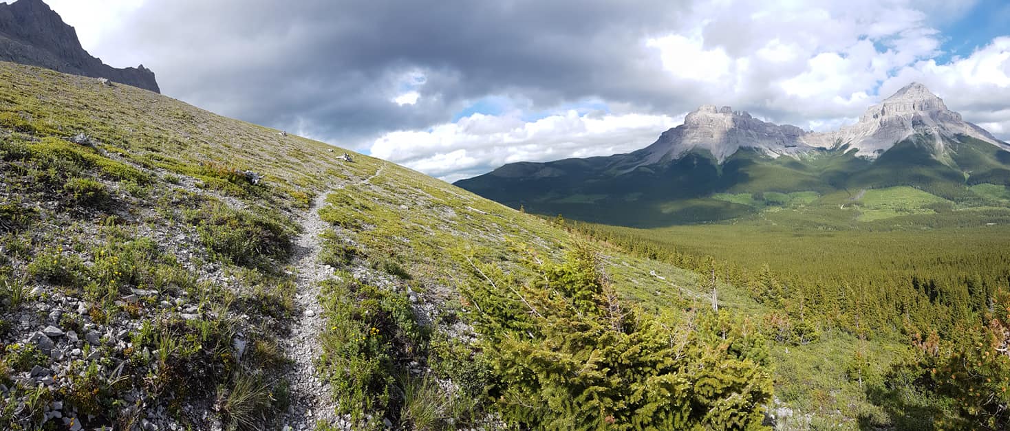
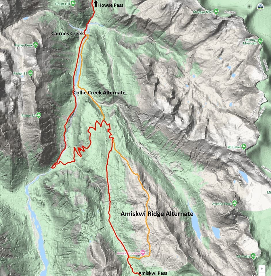
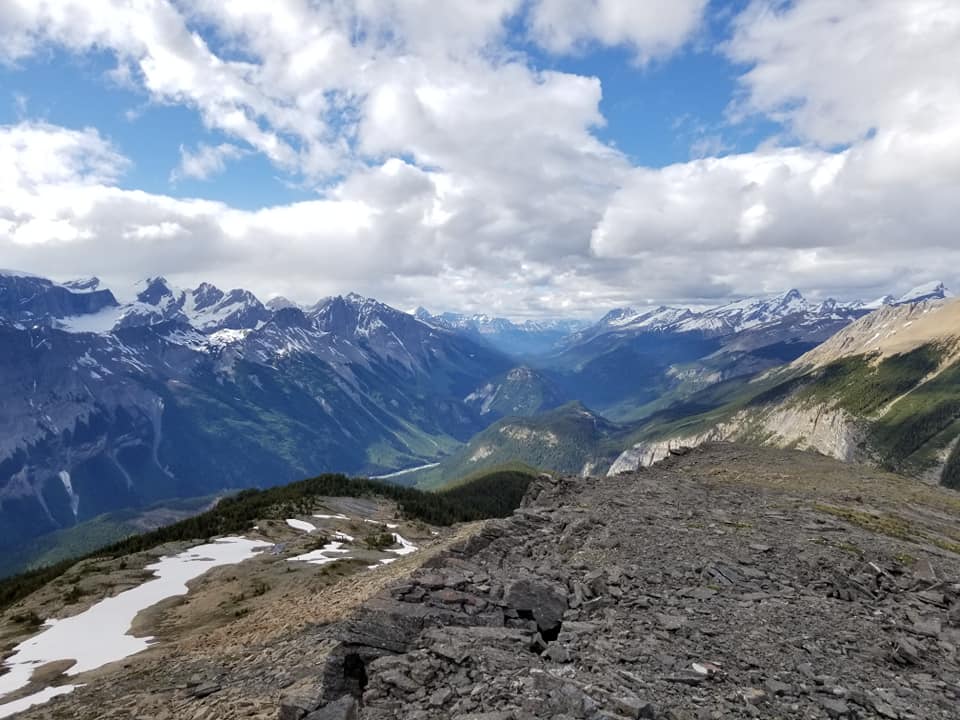
NEW SECTION D ALTERNATE: Amiskwi Ridge. For those who prefer spectacular ridge walking to an active logging road, this alternate is for you!
Amiskwi Ridge
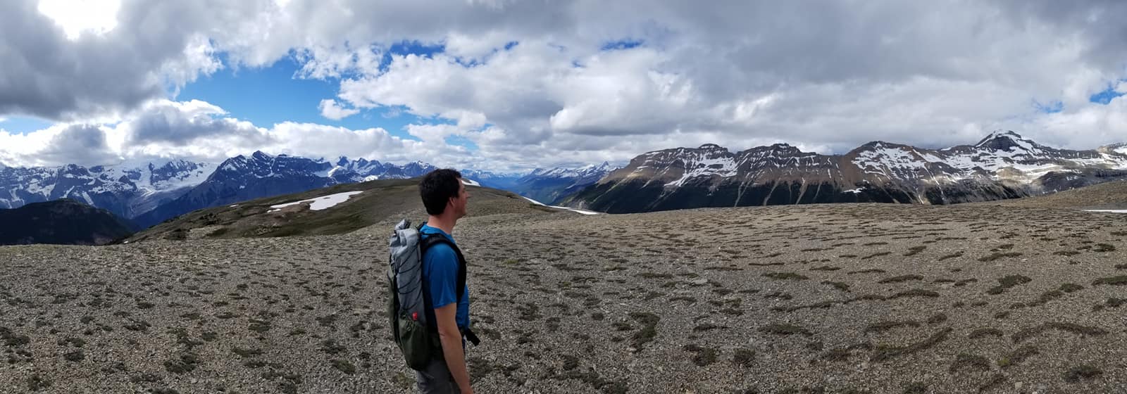
NOBO begin 1.5 km north of Amiskwi Pass by hiking steeply on good trail (+200m over 1 km) to reach Amiskwi Lodge at the tree line, where the trail ends and 5 km of stunning cross-country ridge walking begins. Camping is not allowed at the lodge, please do not trespass on private property. Camping is available in the meadows 200 metres farther.
Ascending Amiskwi Ridge, looking back
Requires some route-finding and a short section of light to moderate bushwhacking. The alternate is 8 km vs 6 km on the main route of the GDT, and highly recommended. Tack on the Collie Creek alternate and you can avoid 20 km of walking on active logging roads.
While Alberta and British Columbia continue to cautiously move into the next phases of living with COVID-19, the Great Divide Trail Association is considering what is best for the health and safety of the trail community that we serve. Staying active in the outdoors is an excellent way to keep your body and mind healthy but we need to continue to do our part to limit the spread of COVID-19.
At this time, the GDTA supports single-day hikes or horseback rides on the GDT and longer (weekend or multi-day), self-sufficient trips that don’t require resupply, where trails and trailheads are open.
Please observe 2-metre physical distancing at all times on the GDT and avoid long-distance ‘thru’ hikes that involve resupplying and interaction with people in communities along the GDT. To limit the potential transmission of the virus between you and others, being completely self-supported on GDT outings is essential. Stay local, bring everything you need, avoid side trips from the trail to resupply, and always Leave No Trace.
Parks Canada re-opened all national parks along the GDT on June 1, and all GDT backcountry campgrounds in the national parks re-opened on June 22. New online reservations for backcountry campgrounds opened on June 24. All existing national park reservations prior to June 22 will be automatically cancelled and refunded in full. Existing reservations from international visitors, including visitors from the USA, will be cancelled and automatically refunded in full up to and including August 7, 2020.
Alberta Parks re-opened all provincial parks on May 1. Campground reservations opened on May 14 for Alberta residents only for camping dates starting June 1. All Alberta backcountry campsites – both reserved and first-come, first-served – now allow 100% capacity.
BC Parks re-opened all provincial parks along the GDT on May 14. Most provincial backcountry campgrounds along the GDT re-opened on June 1 for BC residents. Backcountry camping opportunities remain available for non-BC residents accessing Elk Lakes, Height of the Rockies and Mount Assiniboine provincial parks on the Alberta/BC border through existing established trail routes.
CLOSURES:
Waterton Lakes National Park: The Akamina Parkway is closed to vehicles, pedestrians and bicycles due to construction resulting in no access to Cameron Lake, Akamina Pass, Rowe Lakes or the Mount Rowe Alternate Route. As long as the Akamina Parkway remains closed to hikers, a detour can be followed from Waterton Townsite to reconnect with the GDT via the Crandell Lake Trail, Red Rock Parkway and Blakiston Valley Trail, a distance of about 26 km vs 43 km on the GDT.
Numa Creek Trail (Rockwall access trail) remains closed due to the bridge out over the Vermilion River. The pedestrian bridge is being replaced this summer and access to the Rockwall from this location will be restored later this year.
Trail 7 near Jasper is closed to hikers south of the junction with Trail 7e and north of the junction with Trail 7a due to grizzly and black bears frequenting the area. Detour by taking Trail 4g to Edith Lake from where there are a few options to reach Old Fort Point trailhead or Jasper townsite. Equestrians can still use Trail 7 but are not to dismount.
The public cabin at Kakwa Lake is closed this summer.
TRAIL NOTICES:
Wildflowers are blooming. Trail conditions are improving quickly but expect wet and muddy sections and snow patches at higher elevations. GDTA Trail crews are out maintaining the GDT in July so make your presence known when hiking through a work area and say thanks for all their hard work!
CREEKS: Warm weather means rapid snow melt during the day resulting in high water levels and potentially dangerous creek crossings, particularly later in the day. Attempt to ford larger creeks early in the day when water levels are lowest. In general, creeks and rivers along the GDT are running higher than normal so expect wet and occasionally flooded trail conditions.
BEARS: Bears are out and about. Be bear aware on the trails this summer: be alert, make noise and carry bear spray.
FIRES: There are fire advisories in effect along much of the GDT including in all national parks. If you must have a campfire in the backcountry, ensure you follow the rules.
The GDT is blocked by avalanche debris south of Tornado Pass (b16). Hikers can get around by traversing upslope.
The Rockwall Trail is covered by avalanche debris on the switchbacks north of Numa Pass but the trail is still passable. A Parks Canada trail crew plans to clear the trail later this month.
Cairnes Creek (d9): A new temporary bridge was built on July 18 to replace the two fallen trees that washed away. If the bridge washes away, Cairnes Creek is glacial fed and a potentially challenging ford. It is recommended to ford the creek early in the morning when glacial melt is lowest.
The David Thompson Heritage Trail was cleared from Cairnes Creek to Howse Pass in 2019. A new log bridge is in place across Lambe Creek.
Descending the north side of Howse Pass (d11), the main route of the GDT now follows Conway Creek and Howse River floodplains wherever possible, without crossing the main channel of the Howse River. The floodplain is wide and scenic. There are several shallow fords of smaller channels on the floodplain so hikers must be prepared to have wet feet while enjoying a significantly better hiking experience than the old overgrown trail strewn with hundreds of fallen trees. In June and early July, the Howse River may be in flood making some sections of the floodplain difficult or impassable in which case hikers should consider using the old trail (now marked as an alternate route). Conversely, in late August and September when the river is low, hikers may be able to ford the main river channel and completely avoid any bushwhacking along the river’s edge. See here for a more detailed route description.
The Yates Torrent Bridge is out at the crossing of the Coleman Glacier outflow (near f16). Do not attempt to cross at the old bridge location. There are two options: (1) ford the Smoky River in the floodplain; or (2) ford Yates Torrent approximately 500m upstream (location was flagged in 2017). At both locations attempt to cross early in the morning when glacial melt is the lowest or be prepared for a fast and potentially dangerous creek ford.
The bridges across Gendarme and Carcajou Creeks are out on the Jasper North Boundary Trail. These two creeks are smaller than the Smoky River, but can still be treacherous. Cross Gendarme at the horse crossing just below the old bridge (marked), and Carcajou about 100m below the trail.
ACCESS ROADS:
In Waterton Lakes National Park, the Akamina Parkway is closed to vehicles, pedestrians and bicycles.
Sunshine Road reopened on June 21 but Sunshine Village will be closed for the entire 2020 season, including the shuttle and gondola.


