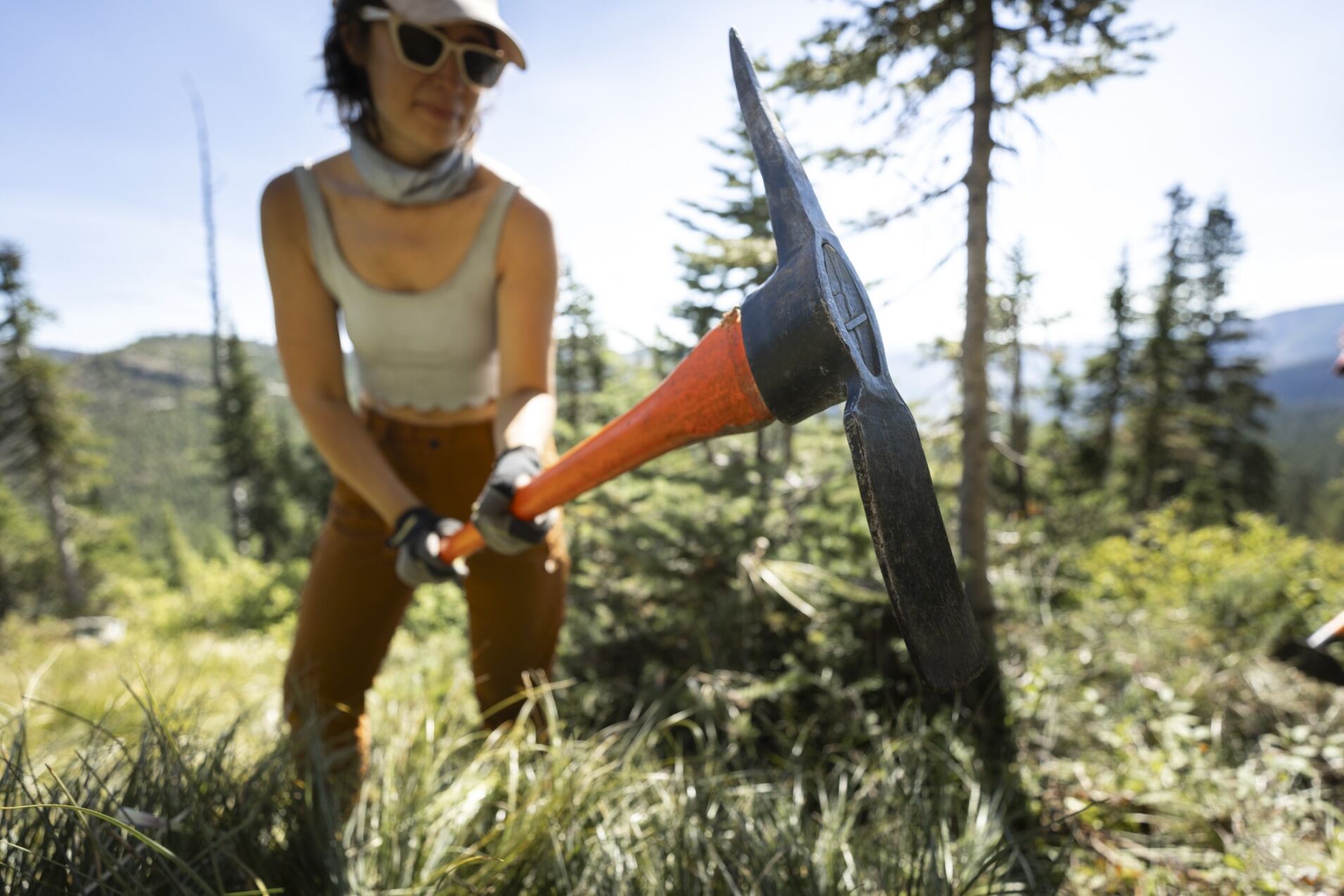
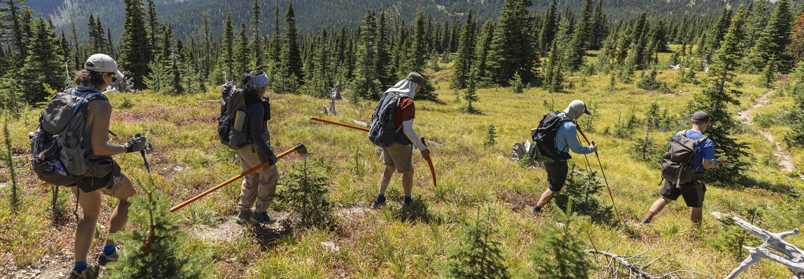
This was the most ambitious year in the field for the Trail Building and Maintenance Committee crews to date, with over 6,000 field work hours put in by 153 volunteers.
The season started with parallel trips into the Blaeberry: one, a basecamp trip to Collie Creek to complete the revival of an old trail to take the GDT off the logging road and the other a backcountry self-supported trip on the David Thompson Heritage Trail to complete trail repairs due to a major avalanche last year.
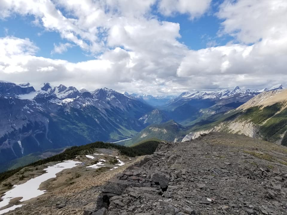
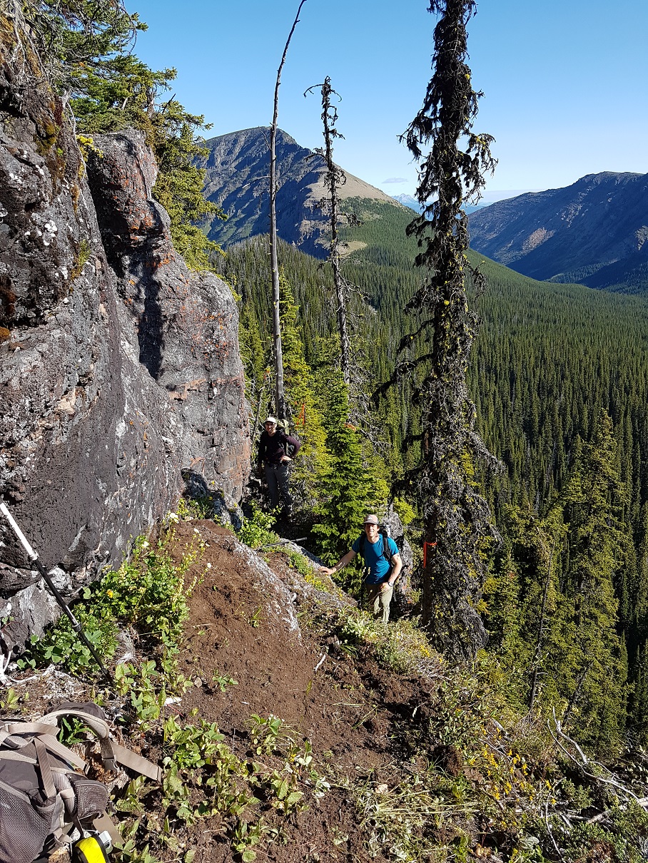
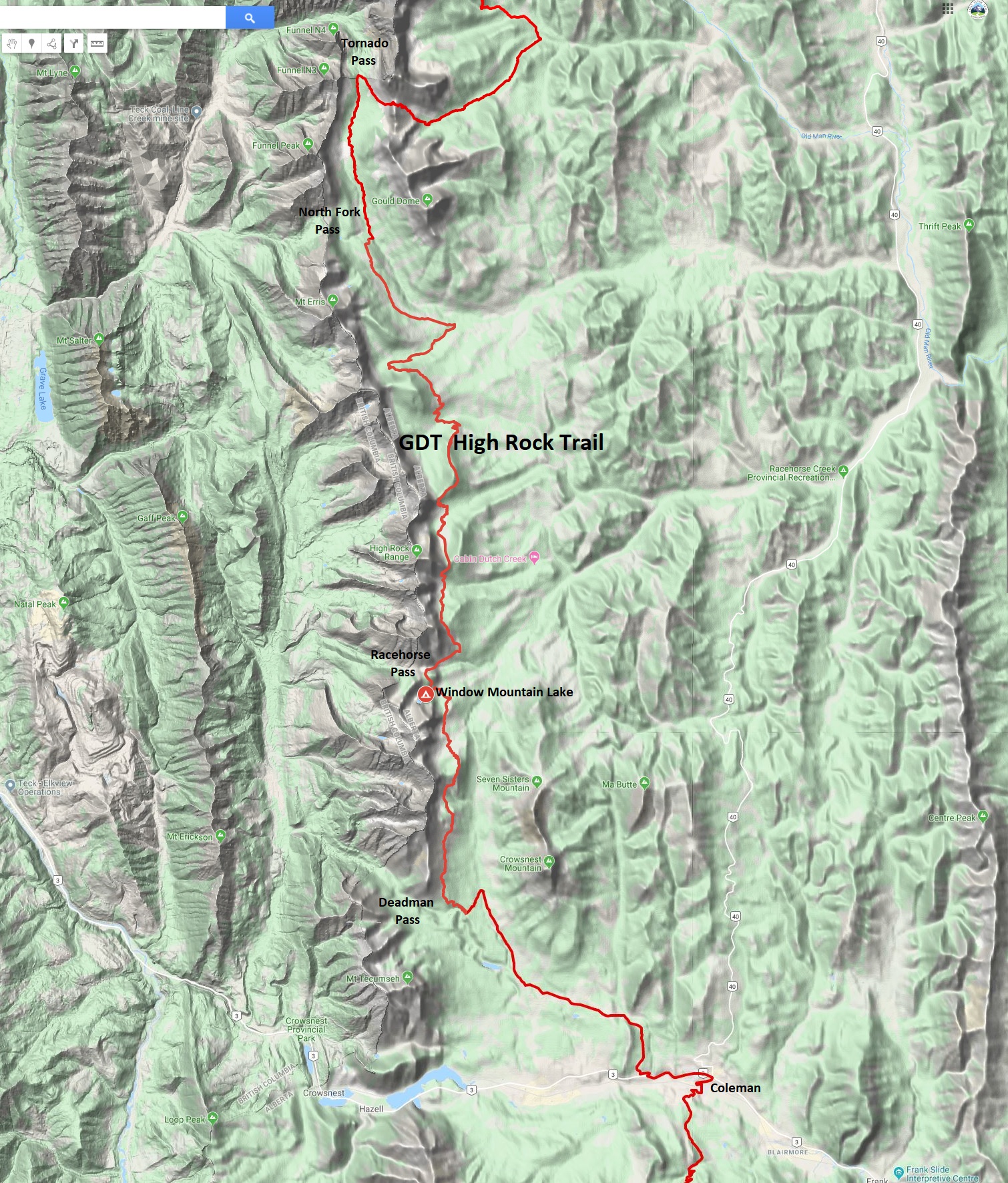
Work on the High Rock Trail between Alison Creek and Window Mountain Lake was completed over 6 backcountry trips, including a new trail completed to take 2 km of the GDT off steep ATV tracks. New signs were installed at key intersections along the route. Deadfall was removed between Window Mountain Lake and South Hidden Creek, and the South Racehorse Creek bridge was repaired. Some trail was rerouted to protect an environmentally sensitive area.
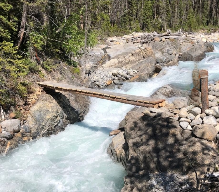
A new bridge was installed across Baril Creek on the Original GDT in Section B. A self-supported backcountry crew replaced the temporary log bridge and completed trail maintenance work up to Fording River Pass and from Baril Creek to just over the ridge to the south.
The first women’s only walking trip from South Hidden Creek to North Racehorse Creek took place in late July. Trail clearing, blazing, and an assessment for backcountry campsites were completed.
In Section A, a walking trip from Sage Pass to Scarpe Pass included trail maintenance and blazing along 14 km of trail, 600m of trail construction from Scarpe Pass to La Coulotte Ridge and an assessment of the campsite at Sage Pass.
Once again, the GDTA partnered with Friends of Jasper to clear and maintain the trail on Maligne Pass in Section E, clearing encroaching small trees and shrubs along 500m of trail east and west of Mary Schaffer Campground.
Two parallel trips were coordinated in Section G. Volunteers on a walking trip from Sheep Creek to Cecilia Lake completed trail clearing and maintenance that was started in previous years. The construction of a bridge at Cecilia Creek was done in parallel and both crews and tools were helicoptered in and out.
Two trips into the White Goat Wilderness Area were completed in collaboration with the Trail Protection and Advocacy Committee to set up and take down trail counters and wildlife cameras at the beginning and end of the trail season. This will help gauge activity along the Cataract Creek trail, to help convince the Government of Alberta to permit maintenance of that trail.
It was a successful season working in challenging conditions of heat and smoke. Thanks to all our volunteers and especially to our hard-working trip leaders who organized each of the trips.
Additional trail construction continues as we fine-tune the High Rock Trail resulting in a few minor route changes.
The new Window Mountain Lake Bypass was completed last summer, creating an equestrian friendly route or shortcut for hikers wishing to skip the lake (which you definitely shouldn’t).
Marmot Lake campground has been added to the GDT campground list. The campground is 700m off the main trail next to a beautiful alpine lake.
Section C:
Elk Pass Trailhead Resupply will continue this year thanks to Nicole Sharpe who has again generously offered to deliver resupply boxes to the Elk Pass Trailhead in Peter Lougheed Provincial Park. The cost is $25 for GDTA members or $40 for non-members. Contact Nicole through Facebook or at nicole.d.sharpe@gmail.com to book your delivery service and receive mailing instructions. Once you’ve paid the fee, Nicole will give you her Zoleo satellite communicator number in case on-trail communication is needed.
Aster Lake campground (on the Northover Ridge alternate route) will be closed this summer for refurbishment.
Egypt Lake campground will be closed starting August 1st during work to replace the Egypt Lake Shelter.
Section D:
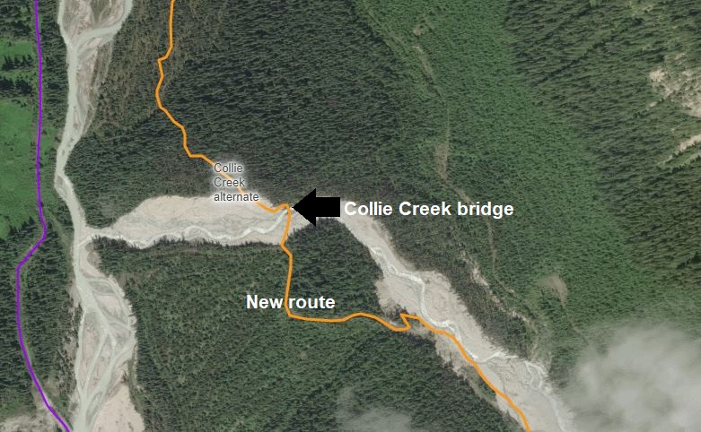
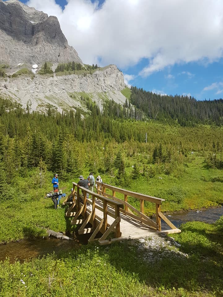
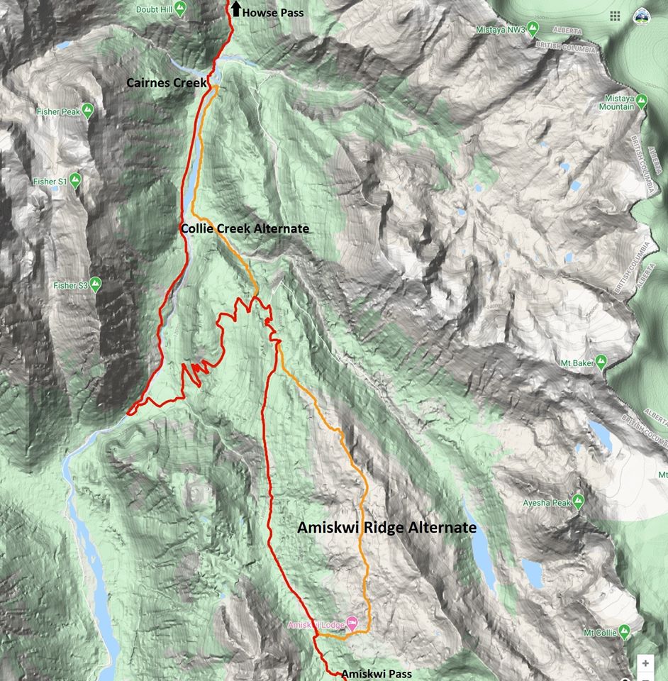
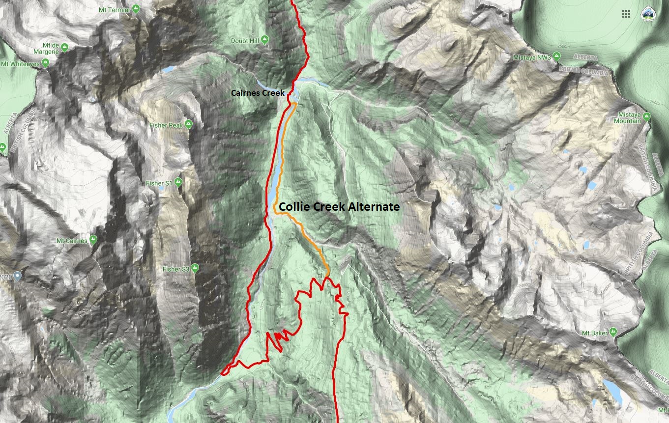
Further improvements to the Collie Creek alternate route took place last summer, including maintenance throughout the existing trail, restoration of an additional 1 km of trail at the south end of the route, and the construction of a bridge over Collie Creek, making it highly recommended this year. Note the new (flagged) route to access the bridge. At the north end of the Collie Creek alternate, a forestry bridge should provide safe passage to continue the GDT on the other side of the Blaeberry River. Be warned that the forestry bridge is slated for removal which could occur as early as mid-August 2023 and the Blaeberry River is generally unfordable prior to September.
Section E:
The Six-Passes Alternate Route is closed again this year to all overnight random camping but is open to random day use activity.
The three campgrounds on the Maligne Pass Trail previously available online as ‘Maligne Pass North’ (Mary Vaux, Mary Schäffer, Trapper Creek) are listed in the online reservation system separately, 1 site per night at each campground.
Section F:
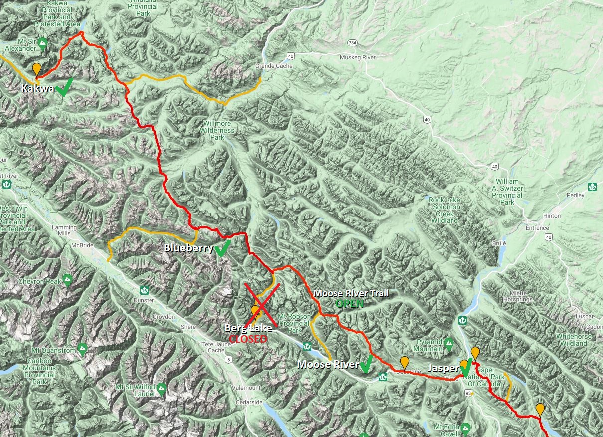
The Berg Lake Trail remains closed and it will not open this summer so hikers should plan accordingly when arranging resupply or exiting the trail.
The Moose River Trail remains open so hikers can connect with Section G via Moose Pass.
Exiting via the Moose River Trail to Highway 16 is another option.
Section G:
With the closure of the Berg Lake Trail, exit or resupply (with support) via the Blueberry Trail are good options.
Robson Valley Adventures Unplugged will not be offering shuttle services to the Kakwa and Blueberry trailheads this summer.
Following the past two years’ successful maintenance trips in the Jackpine valley, the entire trail has been cleared! All of the old trail has been discovered and restored which means the trail now fords the Jackpine River more frequently (20 times). In normal water level conditions these fords are easy and only knee deep but hikers should be aware. In higher water conditions, it is an option to avoid most of the fords by bushwhacking along the original side of the river to cross less frequently.
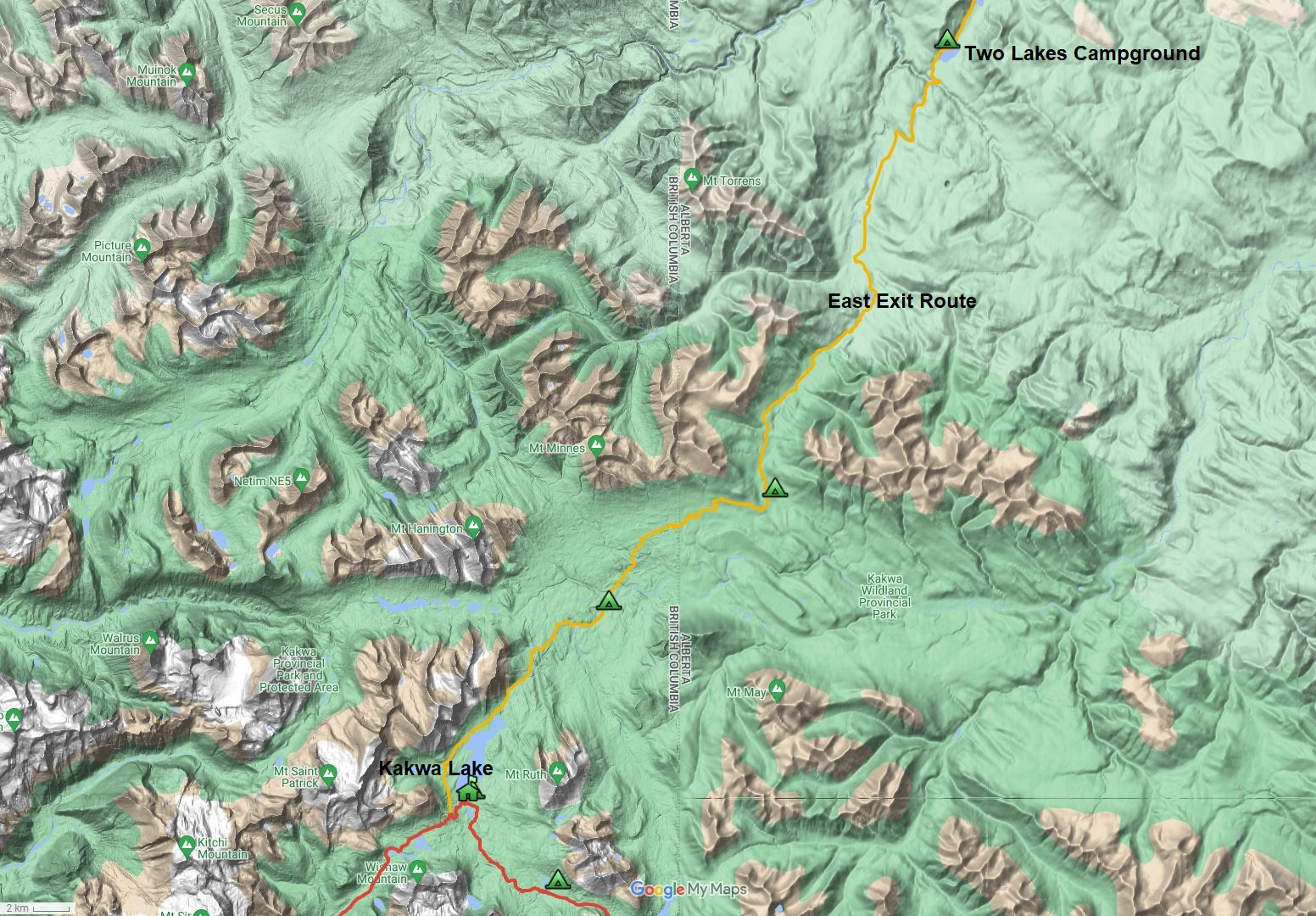
The Walker Creek FSR continues to be in rough shape and BC Parks lists Walker Creek FSR as closed at km 37 due to unsafe road conditions. The road remains accessible beyond that point for those with high clearance 4WD vehicles willing to drive the very rough and overgrown road to from the Bastille Creek trailhead.
As an alternative to the Walker Creek FSR, an eastern exit route from Kakwa Lake has been added. The route runs 26 km on an old tote road plus another 6 km on an old trail to reach the 4WD trailhead at Deadhorse Meadows in 32 km. The walking is generally good, but where boggy sections exist look for singletrack detours that skirt around. From Deadhorse Meadows it is a further 18 km to the 2WD trailhead at Lick Creek. If you don’t have a ride arranged, continue a further 15 km to the popular Two Lakes Recreation Area where your search for a ride should be more fruitful.
Backpackers, hikers, outdoor enthusiasts, would you like to share your passion with others?
Do you want to participate in responsibly creating an iconic Canadian wilderness opportunity?
Do you have 6-10 hours to volunteer each month?
The Great Divide Trail traverses the continental divide between Alberta and British Columbia, wandering through the vast wilderness of the Canadian Rocky Mountains for more than 1100 kilometres. It is one of the most spectacular and challenging long‐distance trails on the planet. The Great Divide Trail Association is dedicated to maintaining, protecting, and promoting the Great Divide Trail. We are currently seeking dynamic, committed, community-oriented Board of Directors candidates.
Qualifications
We are looking for candidates with experience in the following areas:
Finance (succession planning for GDTA Treasurer), fundraising, non-profit/charity governance, organizational development, safety and environment, marketing, communications, member/stakeholder engagement, leadership and public relations skills.
Roles and Responsibilities of the Board
The GDTA is a registered charity, and the Board is accountable for ensuring that the Association is managed in accordance with applicable laws and its membership’s wishes. The Board is responsible to:
Establish and maintain a framework for delegation and internal control within GDTA.
Great Divide Trail Association – Attn: Nomination Committee Suite 200, 940 – 6 Avenue SW Calgary, Alberta T2P 3T1
The nominating committee will review all applications, possibly interview interested persons and then present qualified candidates to the Association’s membership for their consideration at the GDTA Annual General Meeting on Monday, September 26, 2022. There are currently four (4) open Board positions.
Other Volunteer Opportunities
If you are not interested in a Board position but would like to contribute your time and talents in other ways, don’t hesitate to contact the nominating committee.
While pandemic recovery continues and the world continues to reopen, the Great Divide Trail Association continues to consider what is best for the health and safety of the trail community that we serve. Staying active in the outdoors is an excellent way to keep your body and mind healthy, and we encourage everyone who spends time on the GDT this year to do so safely and continue to do your part to limit the spread of COVID-19.
For those considering travel on the GDT in 2022, review and adhere to current Canadian and regional COVID travel guidelines.
At this time, the GDTA supports single-day hikes or horseback rides on the GDT and longer (weekend or multi-day) trips that respect and adhere to local COVID guidelines and public health orders.
To limit the potential transmission of the virus between you and others when on the GDT, please follow these guidelines:
Check with public health agencies for information near your starting point, along your route, and at your planned destination. Any GDT travel must comply with provincial and federal guidelines and laws.
Practice 2-metre physical distancing from other cohorts at all times on the trail.
Avoid crowds, shared facilities and indoor spaces.
Stay local where possible, explore sections of the trail near your home.
Always Leave No Trace.
Backcountry use has the potential to add unnecessary stress to the healthcare system and put public safety staff at risk, including exposure to COVID-19, which could then impact resources to support search and rescue, so please keep your hiking plans conservative and your risk low.
Despite the ongoing pandemic, the GDTA continues our work with your support:
Trail Building and Maintenance trips continue to move forward this summer. Save the Date: the grand opening of the High Rock Trail is on July 22, 2022 – stay tuned.
Our Trail Protection & Advocacy Committee continues to make progress toward our goal of permanent protection of the GDT.
Our 2nd annual Trail Supporter Campaign held by our Ensuring Financial Capacity Committee raised over $21,000 and was a huge success thanks to your generous support!
Our Outreach Committee has planned several exciting virtual events in the coming months to connect the Great Divide Community even if we can’t meet in person due to the pandemic (or the weather!).
The GDTA will continue to monitor and follow the recommendations of the Public Health Agency of Canada and the Provincial Health Authorities of Alberta and BC, and provide updates as new information becomes available.
Thank you for being responsible and taking precautions to keep yourself and others safe!
While pandemic recovery continues and the world slowly reopens, the Great Divide Trail Association continues to consider what is best for the health and safety of the trail community that we serve. Staying active in the outdoors is an excellent way to keep your body and mind healthy, and we encourage everyone who spends time on the GDT this year to do so safely and continue to do your part to limit the spread of COVID-19.
For those considering travel on the GDT in 2021, remember that travel on the GDT is considered non-essential.
At this time, the GDTA supports single-day hikes or horseback rides on the GDT and longer (weekend or multi-day) if they are in your local area, where trails and trailheads are open.
To limit the potential transmission of the virus between you and others when on the GDT, please follow these guidelines:
Check with public health agencies for information near your starting point, along your route, and at your planned destination. Any GDT travel must comply with provincial and federal guidelines and laws.
Travel only with members of your household; practice 2-metre physical distancing from others at all times on the trail.
Avoid crowds, shared facilities and indoor spaces.
Stay local, explore sections of the trail near your home.
Always Leave No Trace.
Backcountry use has the potential to add unnecessary stress to the healthcare system and put public safety staff at risk, including exposure to COVID-19, which could then impact resources to support search and rescue, so please keep your hiking plans conservative and your risk low.
Despite the pandemic, the GDTA continues our work with your support:
Our Trail Protection & Advocacy Committee continues to make progress toward our goal of permanent protection of the GDT.
Our first ever charitable donation campaign held by our Ensuring Financial Capacity Committee was a huge success thanks to your generous support!
The GDTA will continue to monitor and follow the recommendations of the Public Health Agency of Canada and the Provincial Health Authorities of Alberta and BC, and provide updates as new information becomes available.
Thank you for being responsible and taking precautions to keep yourself and others safe!
The Great Divide Trail Association would like to thank our amazing volunteers, who, despite the challenges of 2020, have made this one of our most productive years. As a result of our volunteers’ hard work, the new High Rock Trail was opened, and the Association obtained Charitable Status. In addition to these two significant milestones, advocacy work to protect the Great Divide Trail and support for an increasing number of trail users continued. All of this work was accomplished safely and without a single incident.
On behalf of the Association – THANK YOU!
Building on this year’s success, we would like to do more. The Great Divide Trail Association is 100% volunteer-run, so that means we need you!
If you are an avid hiker, backpacker or armchair enthusiast who would like to share your passion with others.
If you would like to participate in responsibly creating an iconic Canadian wilderness opportunity.
And, if you have a few hours to volunteer each month, consider joining a group of like-minded volunteers dedicated to maintaining, protecting, and promoting the Great Divide Trail, one of the most spectacular and challenging long‐distance trails on the planet.
Volunteers are required for the following committees:
Trail Building and Maintenance Committee – is responsible for planning and managing trail operations. This committee managed almost 100 volunteers who contributed approximately 3500 hours building and maintaining the Trail this past year. Skills and experience needed:
Committee secretarial duties and information management
Equipment inventory, purchases and repairs. Individuals should be located in/near Calgary, where our equipment is housed
Ensuring Financial Capacity Committee – is responsible for fund development and building supporters for the Great Divide Trail Association’s operations. This committee wrote or assisted with several grants this past year, created a grant database, obtained charitable status for the Association, and initiated a donation program. Skills and experience needed:
Committee Co-Chair – leadership skills
Grant writing, researching prospects, maintaining grant database
Developing sponsorships and corporate donations
Advancing the charitable donation program
The Outreach, Education and Engagement Committee – is responsible for building awareness of the Great Divide Trail and the GDTA through effective communication strategies and programs, planning outreach and education events, and supporting Great Divide Trail users. Each year the number of hikers continues to grow. Outreach has provided Trail information and advice to numerous members, hikers, and the public. Skills and experience needed:
Graphic design – managing and updating the Association’s website and social media
Communications and advertising
Program and event planning (live and virtual)
Hiker support – maintaining existing hiker resources and exploring ways to provide additional assistance.
Safety and Environment Committee – assists the Great Divide Association have “zero” safety incidents and environmentally, “leave no trace.” This committee was an integral part of the Association, having zero incidents this past year, including zero “COVID19” incidents. Skills and experience needed:
Safety management – maintaining and supporting the use of the GDTA Safety Program
Working knowledge of Alberta OH&S requirements
Environmental Protection – developing, maintaining, and implementing an Environmental Program and providing environmental expertise for land use applications.
Knowledge of Alberta’s environmentally sensitive flora and fauna and wildlife (to help develop training material for GDT trail building trips)
To volunteer or for more information, please email us with your name, contact information and area of interest(s) to: greatdividetrail@gmail.com
Are you an avid hiker, a backpacker who would like to share your passion with others?
Would you like to participate in responsibly creating an iconic Canadian wilderness opportunity?
Do you have 6-10 hours to volunteer each month?
The Great Divide Trail traverses the continental divide between Alberta and British Columbia, wandering through the vast wilderness of the Canadian Rocky Mountains for more than 1100 kilometres. It is one of the most spectacular and challenging long‐distance trails on the planet. The Great Divide Trail Association is dedicated to maintaining, protecting, and promoting the Great Divide Trail. We are currently seeking dynamic, committed, bright, community-oriented Board of Directors candidates.
Qualifications
We are looking for candidates with experience in the following areas:
Finance, fundraising, operations management, business skills, non-profit/charity governance, organizational development, legal, safety and environment, marketing, communications, member/stakeholder engagement, human resource management.
Roles and Responsibilities of the Board
The GDTA is a registered charity, and the Board is accountable for ensuring that the Association is managed in accordance with applicable laws and its membership’s wishes. These responsibilities include:
Establishing and maintaining a framework of delegation and internal control.
Monitoring financial management and performance.
Establishing and pursuing a strategic direction in keeping with the GDTA’s Mission, Vision and Values.
Reviewing and overseeing the Association’s risk management and compliance systems and programs.
Evaluating and improving the performance of the Board.
Promoting and supporting the Association and its members.
Responsibilities of Individual Board Members
As individuals and collectively, Board Members are responsible for:
Creating a positive, open organizational culture.
Adhering to the bylaws, policies, and procedures of the organization.
Pursuing opportunities to improve the performance of the Association at all levels
Attending all Board meetings in person or via teleconferencing.
Actively participating on at least one of the Association’s committees or as an Association officer.
Acting selflessly in making decisions and working towards positions that are in the best interests of the Association.
Term: Three (3) Years Compensation: None – this is a volunteer position. Time Commitment: Six to ten hours per month
Candidate Selection Process
Interested Candidates should submit their names and qualifications to:
The nominating committee will review all applications, possibly interview interested persons and then present qualified candidates to the Association’s membership for their consideration at the September 2020 Annual General Meeting. There are currently four (4) open Board positions.
The new High Rock Trail is open and now the official main route of the GDT. The GPS track has been posted to the GDT App and our map page where it can be downloaded. We continue to improve the High Rock Trail annually, but it is completely hikeable and totally awesome!
Thanks to all of our sponsors, supporters and the incredible volunteers who worked so hard over the past 7 years to build this new trail!
High Rock Trail
High Rock Trail (HRT) NOBO Description
The High Rock Trail is easily reached from the Atlas (Allison Creek) Road. From the Atlas Staging Area (b4), look for the HRT trailhead at the south end of the staging area on the west side of the road. Heading off on the trail, follow switchbacks down to the new Allison Creek bridge. Fill up with water here, as the next reliable source isn’t until Window Mountain Lake in 16 km. Cross the bridge to reach a junction with the Chinook Lake service road. The HRT climbs to the east but for a refreshing swim on a hot day, head west 1 km to Chinook Lake!
Continuing north, the trail crosses Deadman Pass road – the former route of the GDT prior to the construction of the HRT – as it climbs the forested slopes of the Divide. Follow the trail for 800 metres where you will turn right onto an old ATV track. The track gains 100m over 1 km before a short but steep climb over the last 50 metres marks the end of the track and the return to single-track trail at 1740m.
HRT Trail Crew
The trail climbs steadily for 600 metres to reach treeline at 1820m. The trail remains above treeline with spectacular views of Crowsnest Mountain to the east, contouring between 1840m and 1920m for the next 3 km. The trail intersects with an ATV track before dipping back into the forest. In 100 metres, you reach another intersection with the same ATV track and again stay on the trail in the forest, continuing north. The trail stays in the forest for 350 metres before reaching treeline again at the beginning of a short steep climb up a talus slope. The trail climbs 100m over 500 metres, staying just above treeline before the gradient eases off at 2000m. Continue for 1 km, contouring above treeline and up a set of switchbacks through sparse trees to a forested ridge crest. Follow the forested ridgeline for 500 metres to a high point at 2100m (b6) with incredible views of the Crowsnest valley, until the trail veers away from the ridge dropping into the forest. In 100 metres, the trail enters an old cutblock where it will mostly remain for the next few kilometres. There is regrowth in the old cutblock but still many outstanding views of the impressive headwall of the Great Divide.
The trail gently descends through the old cutblock, losing 150m elevation over the next 1.5 km. Cross an ATV track in 1.2 km and in 300 metres reach a second ATV track at the valley bottom at 1940m. Cross this ATV track to follow new trail paralleling the base of the headwall for 1.7 km, including a short steep climb to bring you to the western edge of the cutblock at 2020m. Single-track trail continues through old cutblocks and adjacent forest for 1.6 km until reaching the Window Mountain Lake trailhead and junction with the WML Bypass Trail. Note that horses are not able to access Window Mountain Lake but can take the Bypass Trail to continue north on the HRT.
Window Mountain Lake
Follow the Window Mountain Lake trail, very steep in sections, for 900 metres to reach Window Mountain Lake campground (b7) on the shores of the beautiful lake. The HRT continues through the campground heading up the sparsely treed slopes on the north end of the lake. The trail climbs well graded switchbacks up to the top of the ridge surrounding the lake, reaching a high point at 2120m in 1 km. On the north side of the ridge, you will see the road descending from Racehorse Pass below you. Follow the edge of the forest where it meets the talus slope on your right, descending steeply to the reach the road in 500 metres at 2060m.
Follow Racehorse Pass Road east for 1 km to a marked junction where the trail leaves the road and begins climbing the open slope. Follow the trail as it climbs steep switchbacks over the next 2.4 km to reach Racehorse Shoulder at 2255m (b8), the highest point on the entire HRT with impressive views in all directions. The trail has an alpine feel as it descends the north side of the ridge at the edge of a lovely larch forest, and in 2.5 km reaches a junction with an ATV road in an alpine basin at 1980m. An emergency shelter is located 3.5 km east down this road.
Racehorse Shoulder
The trail continues for 700 metres across the basin and into the forest before starting a steep climb. Over the next 1.5 km, ascend several switchbacks climbing to the saddle between Hail Ridge and the main divide at 2165m. Descend more gently on the north side of the saddle, 1.3 km down to an old road at 2000m in an old cutblock in the open basin below the huge headwall of the divide. Follow the old road for 800 metres as it curves northward to reach a signed trail junction (b9). First Creek campground is 200 metres off route to the right (northeast). The HRT follows the trail left (northwest), across the First Creek Bridge, for 1.3 km as it ascends along the eastern edge of an old cutblock until the trail enters the forest at 1980m. In another 700 metres of steady climbing, the trail reaches the saddle at 2060m. A rest stop with an excellent viewpoint lies slightly off route, 100 metres west of the saddle.
First Creek Bridge
The trail continues northeast, contouring around the east side of Domke Ridge, reaching a high point of 2185m (b10) in 1.3 km. Regain the crest of the ridge and follow it for 1.1 km descending gradually to 2045m at a point where the trail drops sharply off the east side of the ridge into the forest. Descend a series of switchbacks over the next 1.9 km to a junction with an ATV road at 1815m. Follow the ATV road west for 400 metres to a ford of North Racehorse Creek (b11). Good camping exists on a flat bench on the north side of the creek.
Leaving the creek, stay left at a junction and follow the ATV road for 150 metres to where a signed single-track trail leaves the road to enter the forest. Follow the trail as it climbs gradually through thick forest. In 1.3 km cross an ATV track and continue climbing for another 900 metres before levelling out around 1990m. For the next 1.8 km, the trail contours between 1980m and 2020m with good views of Gould Dome and Tornado Mountain to the north. The trail then descends 100m to reach an old ATV track in 750 metres.
Follow the ATV track for 1 km to a junction. Stay left (north) at the junction and descend slightly to cross Fred Bridge. Continue following an ATV road northeast for 2.4 km to a junction with an old logging road at 1715m (b12). Good camping next to Dutch Creek exists 200 metres down the road to the right. The HRT continues left (northwest) following the old road for 4.2 km, climbing gradually through several old cutblocks until it ends at 1910m. The trail briefly turns northeast before it begins following an old seismic line north. In 900 metres, the trail turns sharply east into the forest before descending 60m over 400 metres to reach the Dutch Creek Bridge (b13). Just beyond the bridge, the HRT reconnects with the original GDT as it descends from North Fork Pass.
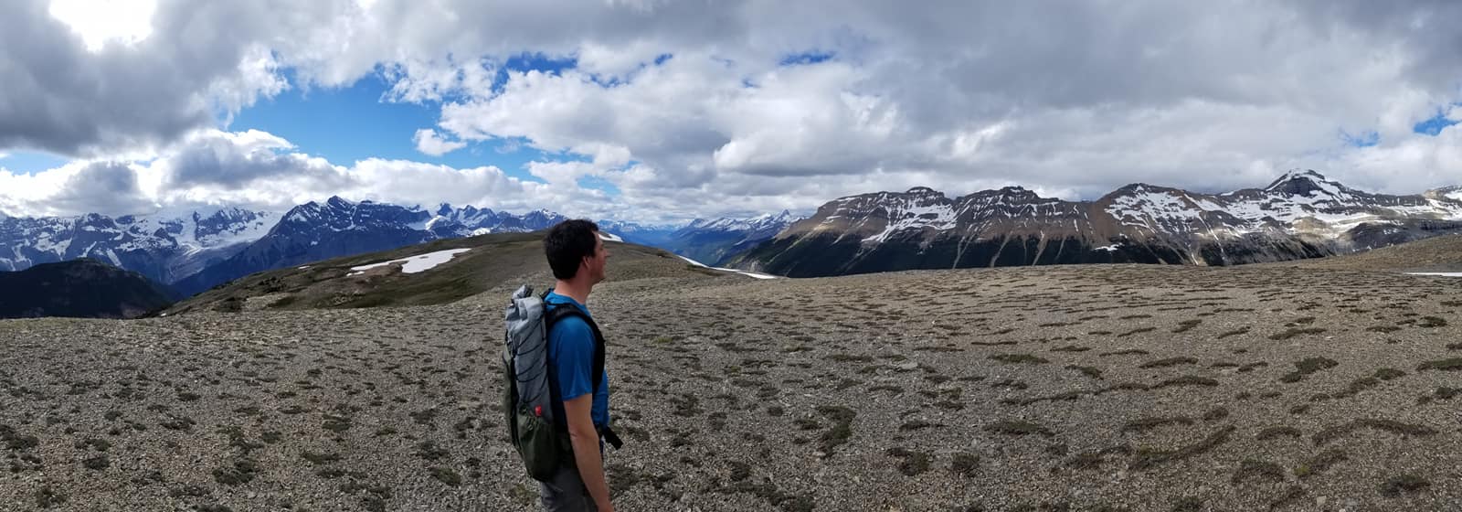
NEW SECTION D ALTERNATE: Amiskwi Ridge. For those who prefer spectacular ridge walking to an active logging road, this alternate is for you!
Amiskwi Ridge
NOBO begin 1.5 km north of Amiskwi Pass by hiking steeply on good trail (+200m over 1 km) to reach Amiskwi Lodge at the tree line, where the trail ends and 5 km of stunning cross-country ridge walking begins. Camping is not allowed at the lodge, please do not trespass on private property. Camping is available in the meadows 200 metres farther.
Ascending Amiskwi Ridge, looking back
Requires some route-finding and a short section of light to moderate bushwhacking. The alternate is 8 km vs 6 km on the main route of the GDT, and highly recommended. Tack on the Collie Creek alternate and you can avoid 20 km of walking on active logging roads.
By Brad Vaillancourt, Dan Durston and Rogier Gruys
While there have been many improvements to the GDT other the past few years, there are still several sections of road walking that offer less than appealing hiking experiences, including the West Castle Road in Section A, highway walking in Coleman, the first 60 km in Section B, the Blaeberry valley in Section D, and the start of Section F out of Jasper. So in the spirit of a new decade, described below are some new and improved alternate routes that offer far more interesting, rewarding and in some cases more challenging hiking experiences that GDT Hikers should consider on their next hike to avoid road-walking. GDTA maps and the Guthook App have been updated accordingly.
SECTION A
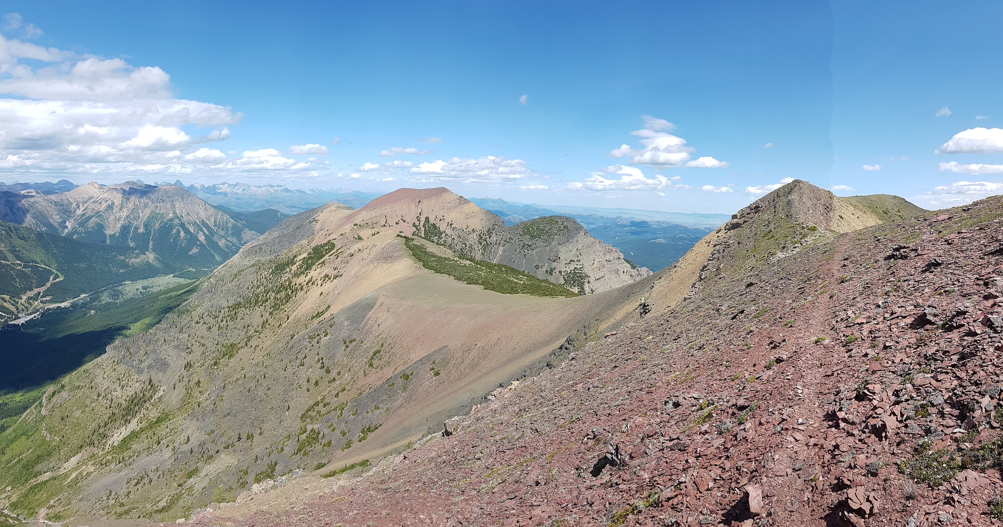
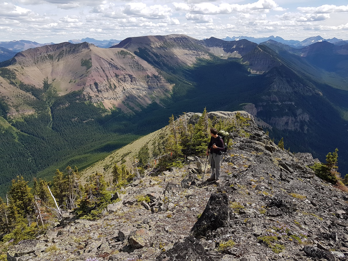
Barnaby Ridge (23.5 km vs 24 km on the GDT) is a spectacular alternate route that is significantly more scenic and rewarding than the valley-bottom dirt road that the main route of the GDT follows but requires significantly more effort. In his guidebook, Hiking Canada‘s Great Divide Trail, Dustin Lynx describes the Barnaby Ridge route as “beyond the scope of hiking” due to some difficult scrambling along the ridge, taking perhaps twice as long as walking down the valley. Other than remnant snow, the ridge is waterless but there are three campgrounds along the route, Grizzly Lake (400 metres off route) at km 6.5, Southfork Lakes at km 19 and Barnaby Lake at km 19.7. In 2019, a small crew of GDTA volunteers set out to find and mark non-technical routes bypassing the most difficult scrambles on Barnaby Ridge and assess whether the ridge could be used as the main route of the GDT.
Awesome Barnaby Ridge
Heading NOBO from La Coulotte Peak (a26), the first major obstacle is the immediate downclimb from the summit where hikers must scramble down steep shale-covered rock steps to reach the ridge crest, where travel becomes easier.
7 km north of La Coulotte Peak is the second major obstacle: an imposing 8m cliff about 500 metres north of the Grizzly Lake trail junction @ 49.25499, -114.33656. The cliff is too large and steep to be safely climbed in either direction without a rope. A route traversing the northeastern side of the ridge, bypassing the cliff, has been cleared and flagged, including scrubbing the route clear of vegetation and placement of a large stepping stone to considerably decrease the difficulty of the scramble. Approaching NOBO 20 metres south of the cliff, look for flagging in the trees on the east side of ridge marking the start of the traverse. Descend slightly and follow a narrow path along the steep eastern edge of the ridge, scrambling down and up a few rock steps before rejoining the ridge crest beyond the base of the cliff. The total distance of the bypass traverse is only 40 metres.
Traverse to avoid cliff
3 km farther NOBO, the second and most challenging obstacle is a 500 metre-long very narrow and rocky crest starting @ 49.280221, -114.341266. This section of the ridge is very exposed with a lot of loose rock and has resulted in more than one hiker abandoning the ridge and detouring straight down to the West Castle Road (not an easy descent). A non-technical route has been blazed traversing below the east side of the ridge that avoids all of the difficult scrambling along the ridge crest. Look for an orange blazed cairn marking the start of the route. The route contours around the east side of the ridge for 650 metres, until you reach an orange blazed arrow indicating where to start climbing. A steep but easy scramble up a rocky gully leads to a large cairn at 2400m at the north end of the narrow crest where relatively easier hiking continues north along the ridge.
Looking back at the crux
The GDTA crew also cleared the trail of deadfall along the forested crest north of Grizzly Lake, but the trail through there is still quite brushy. Even with these improvements, we decided that Barnaby Ridge should remain an alternate route as the difficulty level, particularly in bad weather, is still just a bit too high overall. It is definitely a spectacular route that with these improvements deserves the attention of more GDT hikers.
Crowsnest Pass Community Trail (2.5 km vs 3.6 km on the GDT) – The main route of the GDT follows roads or busy Highway 3 for 4 km through Coleman. Hikers resupplying in Coleman will have to walk at least a portion of this distance but there is a much quieter non-motorized trail next to the Crowsnest River that bypasses most of the road walking. NOBO, after crossing the bridge over the river on 83 Street, turn left (west) onto 14 Avenue. In 180 metres you will reach a T-junction with 81 Street. Turn left (south) to find the Crowsnest Pass Community trailhead next to the Crowsnest River. Follow the riverside trail west for 1.8 km until you reach an intersection with 67 Street (dirt road). Turn right (north) and follow 67 Street as it curves northwest for 450 metres to reach Highway 3. Carefully cross the highway to rejoin the GDT at the 66th Street intersection (b1).
Crowsnest Pass Community Trail
SECTION B
The NEW High Rock Trail (45 km vs 46 km on the existing GDT) – Construction of the High Rock Trail began in 2016 as the first new section of trail on the GDT in more than 30 years. It is a beautiful route, staying close to the Divide and above treeline for much of the route.
On the High Rock Trail
NOBO, the High Rock Trail begins at the Atlas Staging Area and rejoins the existing GDT near North Fork Pass (b13), eliminating more than 30 km of road walking. The GPS track has been posted to our map page where it can be downloaded. The High Rock Trail will officially become the main route of the GDT in 2022!
High Rock Trail
SECTION D
Amiskwi Ridge (8 km vs 6 km on the GDT). For those who prefer spectacular ridge walking to an active logging road, this alternate is for you!
Amiskwi Ridge
NOBO begin 1.5 km north of Amiskwi Pass by hiking steeply on good trail (+200m over 1 km) to reach Amiskwi Lodge at the tree line, where the trail ends and 5 km of stunning cross-country ridge walking begins. Camping is not allowed at the lodge, please do not trespass on private property. Camping is available in the meadows 200 metres farther.
Amiskwi Ridge Alternate
The route requires some route-finding and a short section of moderate bushwhacking. The alternate is 8 km vs 6 km on the main route of the GDT, and highly recommended. Tack on the Collie Creek alternate and you can avoid 20 km of walking on active logging roads.
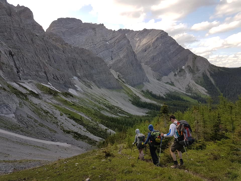
Collie Creek Alternate (6 km vs 14.4 km on the GDT) is a shortcut that skips much of the road walking in the Blaeberry valley and instead offers a shorter journey on old trail and floodplain. From where it leaves the Ensign Creek FSR, the Collie Creek alternate runs 6 km to reach the David Thompson Heritage trailhead while the official GDT travels a longer 14 km on the road to reach the same point. Many hikers will prefer the Collie Creek alternate for its much shorter distance and more interesting terrain, but it does include challenges – most notably a potentially tough ford of Collie Creek.
Collie Creek Alternate
For a NOBO hiker, the Collie Creek alternate begins after 8 km of road walking on the active Ensign Creek FSR (watch out for logging trucks). The alternate leaves the GDT on the outside of a sharp switchback at 1650m elevation as you descend into the Blaeberry valley. Look for an old trail leaving the road directly at the outside of the sharp bend @ 51.678487, -116.698431. The entrance is subtle but easily found by those looking for it.
This trail descends 1.2 km (and 320m elevation) to reach Collie Creek. The trail itself is in poor condition as it hasn’t been regularly used in decades, but it is fairly easy to follow and makes for reasonably fast travel. Despite poor maintenance and a steep grade, hikers will soon see the Collie Creek floodplain through the trees, which historical floods have carved out into an impressively wide cobble strip – many times wider than the creek itself. Collie Creek flows from the Wapta Icefield which also supplies the mighty Mistaya River that you will cross in a couple days’ time (at a bridge thankfully).
When you reach Collie Creek you have arrived at the crux of the route, as you must either ford the creek or retreat steeply back to the GDT. The route ahead travels NW 1.4 km down the Collie Creek floodplain with ample cobble to walk on either side of the creek, so there is flexibility in where you ford Collie Creek but it must be done at some point. Like Cairnes and Lambe creeks ahead, the water level rises late in the day as the summer sun melts the icefield, so crossing in the morning and/or during cool weather eases the task. The suggested route crosses Collie Creek after about 300 metres in a braided portion of the reach (but this may vary from year to year). Beyond this, the slope of the creek steepens, so if you haven’t found a suitable crossing by this point then it is suggested you turn back.
Once across Collie Creek, complete the section on the cobbled floodplain, now on the north side of the creek as you enjoy spectacular views of Mt. Cairnes ahead. Atop that impressive cliff face is the Cairnes Glacier, out of which flows Cairnes Creek which the GDT later crosses. Collie Creek itself is named for J. Norman Collie, who completed many first ascents in the area including Howse Peak and the lofty (3612m) Mt. Forbes in 1902 – both of which you will see later in Section D from the Howse floodplain.
About 150 metres before the creek reaches the Blaeberry River, enter the woods on the north side of Collie Creek and follow a brushy trail for 150 metres in a NW direction to reach a large old floodplain above the east bank of the Blaeberry River. Don’t be tempted to descend all the way to the Blaeberry River, as travelling upstream along the banks of Blaeberry is initially difficult until the floodplain starts.
Once you have reached the floodplain, your task is to travel 3 km up river until you reach a new bridge (built in 2019) over the Blaeberry that will allow you to cross the river and join the official GDT at the start of the David Thompson Heritage Trail. This 3 km is mostly loosely treed floodplain that makes for enjoyable and reasonably fast travel. Route-finding along the way is straight forward with the Blaeberry River always on your left (west) to aid navigation. When you arrive at the bridge, cross the river to rejoin the GDT near Cairnes Creek Rec Site at the David Thompson trailhead (d9).
SECTION F
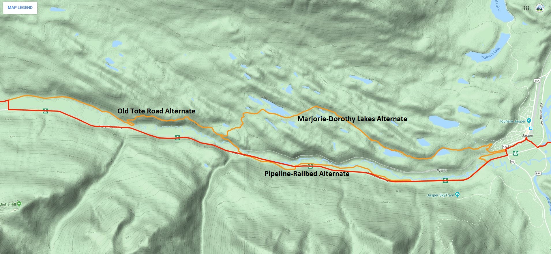
Jasper to Miette River Trailhead(23.3 km vs 21 km on the GDT) – The 21 km of walking next to Highway 16 out of Jasper is the longest (and possibly most dangerous) road walk on the entire GDT that many hikers justifiably choose to hitchhike rather than walk. In his guidebook, Hiking Canada‘s Great Divide Trail, Dustin Lynx suggests an alternate route via Minnow Lake that includes a gnarly cross-country section to the Dorothy-Christine Lakes trail. Combine the Minnow Lake alternate route with the historic Tote Road (described below; also included in the 3rd edition of Hiking Canada‘s Great Divide Trail) and the walk next to the highway can be completely eliminated. However, if the Minnow to Dorothy Lake bushwhack doesn’t appeal to you, there is now a second alternate route out of Jasper.
Jasper Alternate Routes
From Jasper town centre, follow the Discovery Trail (trail 11) west to where it passes under the train tracks and crosses Connaught Drive at a gated intersection with Wynd Road. Follow Wynd Road west for 500 metres to where a hiking trail leaves the road on your left (south) and continues paralleling the road. This junction may not be easy to see, but one can also continue a bit farther on Wynd Road to the official start of Trail 3J. Look for the (white) back of a directional map sign. In 625 metres, the trail takes a sharp left and heads southeast for 400 metres down to Highway 16, eliminating 1 km of highway walking. From the end of Trail 3J, hikers must walk the shoulder on the north side of the highway to the start of the pipeline route (This is the only highway walking on this alternate).
In 3.3 km leave the highway, walk through a parking lot and head towards the Miette River to reach the open, grassy pipeline right-of-way in 100 metres. The pipeline right-of-way is a winter cross-country ski route. There is no actual trail tread and in the summer it may be wet in spots but it is easy walking and much preferred over the highway shoulder. Follow the pipeline route for 4.8 km, until the pipeline turns north towards the river. Leave it and return to the highway. Note for 2020: The pipeline operators may be doing maintenance work on the pipeline this summer, which means you may not be able to walk along the route. Since the pipeline is close to the highway, it is easy to return to the highway if the pipeline right-of-way is blocked.
From this point it is another 2 km along the highway to the Dorothy-Christine trailhead but if you want to continue to avoid the highway and are feeling energetic, cross the highway and climb the slope to an abandoned railbed. The old railbed is easy to follow as it parallels the highway but heavily overgrown with alder in sections so be prepared for some serious bushwhacking. Follow the railbed for 2.3 km, until it drops back to the highway near the Meadow Creek Bridge. Cross the bridge and the highway to reach the Dorothy-Christine trailhead. From here it is still 10 km along the highway to the Miette River trailhead, but now you have the option to follow the Old Tote Road.
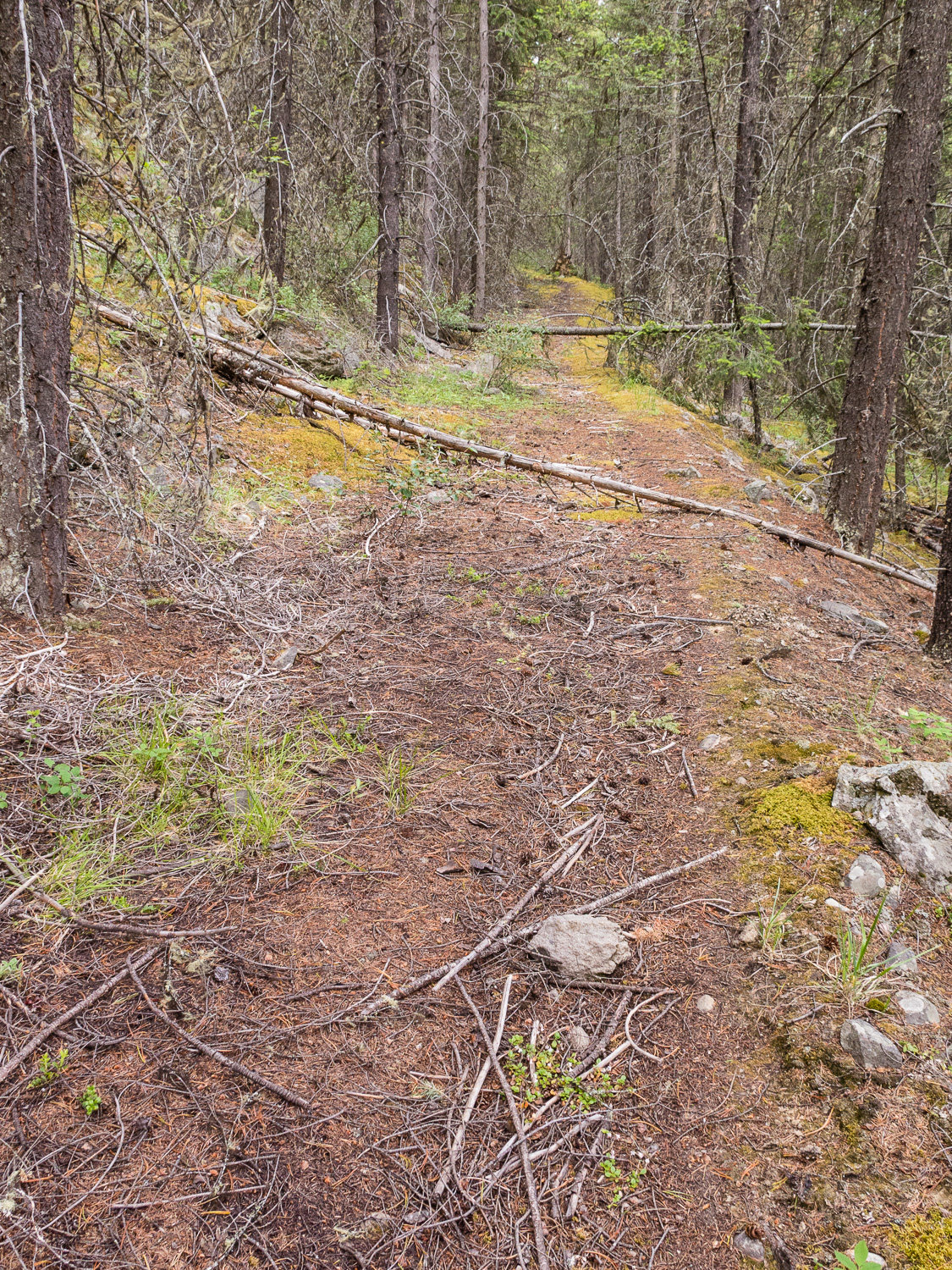
The Old Tote Road was built during the construction of the railroad in the early 1900s. It has not been officially maintained since then, but it is still in surprisingly good shape and easy to follow for most of the way. From the Dorothy-Christine trailhead, walk down the gravel road to the railroad tracks and cross the tracks on the official pedestrian crossing. The trail crosses a new bridge across the Miette River and heads uphill. From the bridge walk about 1 km to just before a sharp right switchback turn in the trail. The indistinct junction with the Tote Road is @ 52.873693, -118.263953 about 20 metres before the switchback, heading northwest at a slight left angle. The Tote Road is overgrown here, so this junction can be difficult to see. When coming from Dorothy-Christine Lakes, descend the well-maintained trail towards Highway 16 until the last switchback, where the trail turns sharply southeast. Look for the junction with the Old Tote Road 20 metres past the last turn.
Old Tote Road junction (photo by Rogier Gruys)
In most places, the old road looks like a faint trail but the tread is inconsistent and navigating around blowdown might cause you to lose the track. Look for rows of rocks, which were used to delineate the downhill side of the Tote Road. The road climbs steeply for the first 200 metres beyond the trail junction until levelling out. From here, the road contours along the mountainside at approximately 1200m. It is very faint to non-existent in places, so keep an eye on the canopy which in most places has a distinct opening where the road is/was. In about 600 metres, the road improves significantly and hiking becomes easier.
Old Tote Road (photo by Rogier Gruys)
Continue hiking west for about 1 km to a creek bed and fire guard where the road can be difficult to find. Beyond here the road is easy to follow for 400 metres until it disappears in an open area. Pick up the road again across the meadow where it should again be easy to follow. In 1.3 km you join the old Golden Lakes Trail. Follow the surprisingly good Golden Lakes Trail 1.2 km downhill to an overgrown trailhead parking area. Follow an old road bed west out of the old parking area. In 1.4 km the road becomes an old railroad bed. Follow this beautiful railbed west for 4 km, past the Decoigne station, all the way to the Miette River trailhead (f1) to rejoin the GDT.
Aside from a bit of bushwhacking and route finding, this is a very pleasant route, and a wonderful historic alternative to walking along the highway!
OTHER UPDATES
Kiwetinok Alternate – The start of the climb up to Kiwetinok Gap now begins 650 metres farther down the Kiwetinok valley in order to avoid the worst section of bushwhacking.
Perseverance High Route – Two updates to the Perseverance High Route eliminate two difficult scrambles and enable almost entirely good travel in the first half of this alternate, south of Perseverance Mountain.
Perseverance High Route
The first update is a detour that avoids the steep, loose scramble descent into upper Spider Creek basin. This section is replaced with a pleasant journey over a highly scenic pass that is slightly longer (7.6 km vs 5.2 km) but not slower as it offers much improved footing and easier hiking. NOBO, split off the original alternate route in the headwaters of Castor Creek valley, 7.2 km beyond the junction with the Jackpine Mountain Trail (g7). Here, the original route traverses above a cliff band. When possible at the end of this cliff band, leave the original route and contour around the alpine bowl you are in at 2000m to 2075m to reach the south-facing side. Contour entirely around this bowl and continue north over the subsequent shoulder just above treeline at 2040m to reach a second valley north of the original one. Descend gentle slopes below talus fields to reach the open valley bottom of this unnamed tributary of Castor Creek after 3 km, where excellent camping exists. From here, the remaining 4.5 km back to the original alternate is simple navigation. Walk a pleasant 3 km up the open valley past a beautiful green alpine lake to the obvious pass at 2275m at the west end of the valley. Once over the pass, the initial 400 metres of the descent are talus which range from medium to very large sizes. Use caution and choose a descent path that avoids the largest blocks and provides the least steep grade. After the talus, stay right (north) around a small cliff band and then continue to walk the fall line downhill as you enjoy the final kilometre of pleasant walking on gravel and marvel at the steep face south of you that the original route descended. Continue downhill and rejoin the original route at the point where views open up of the entire Spider Creek valley. Travel on the High Route is relatively straightforward until the next detour is reached in 5 km.
The second update is a detour that replaces a very steep portion of the original route at the saddle immediately south of Perseverance Mountain. This detour begins @ 53.42668, -119.7606 where NOBO you will veer right in an ESE direction to walk a gentle ramp to the valley bottom rather than descending the 40 degree slope ahead. During this 1 km descent you will have ample views of the 450m upcoming climb to the summit of Perseverance Mountain, allowing you to assess the path ahead. From where you reach the valley bottom, the ascent up Perseverance Mtn is steep but much less so than the original route. From this point, almost any route up this face will work. The suggested route links a series of benches to minimize the grade, but hikers can ascend this face in whatever style suits them with little difficulty to reach the summit. North of Perseverance Mountain substantial challenges remain, including some difficult scrambling.
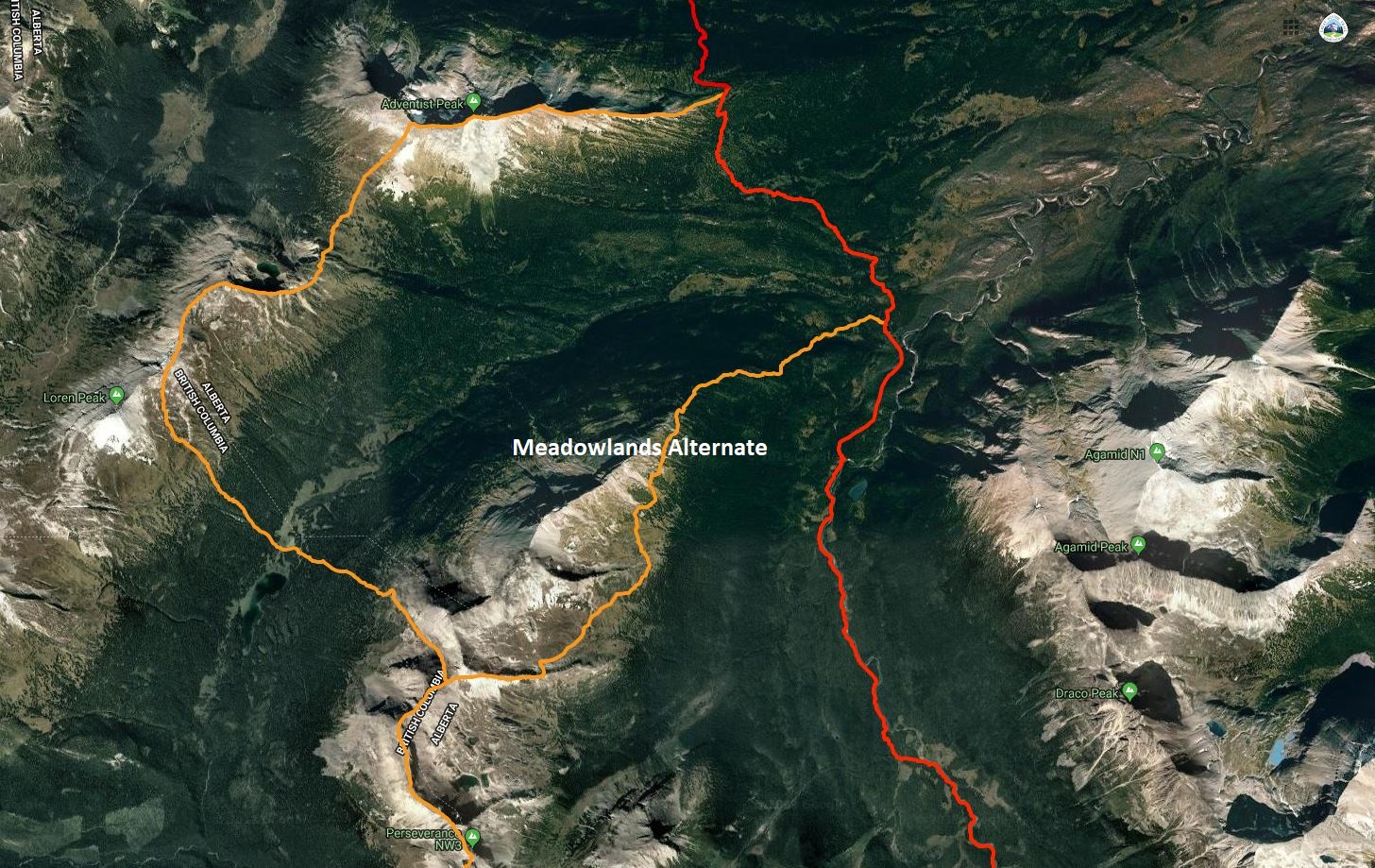
Meadowlands Alternate – is a new northern access route to/from the Perseverance High Route, 9 km to the GDT + 4.8 km to Little Shale Hill = 13.8 km total vs 14.8 km on the original alternate route.
Meadowlands Alternate
Rejoining the official GDT from the northern end of the Perseverance High Route poses a substantial challenge for anyone on this alternate. There are many ways to make this linkage. All of them include some challenges, but none more so than the northernmost section of the original alternate route which includes onerous bushwhacking through Loren Pass followed by very difficult scrambling before re-joining the GDT on Little Shale Hill. A suggested way to make this linkage that reduces the difficulty and improves the hiking quality is to continue generally along the divide of the Jackpine River and Meadowlands Creek valleys to rejoin the GDT at the ford of Meadowlands Creek.
From the summit of Perseverance Mountain, the High Route follows the watershed ridge of the Great Divide for 6.6 km as it passes above three large alpine bowls including a few challenging scrambles. As you reach the northern end of the 3rd bowl, the original alternate descends off the ridge in a NW direction. Rather than descending, continue a further 200 metres NE along the ridge to a point where you could turn north to remain on the ridge crest (a more difficult but scenic high route), but instead head east on the new recommended route following the sub-ridge that divides the 3rd bowl from a 4th bowl. After about 1 km along this sub-ridge, a short scree chute on the north side allows for a quick descent into the 4th bowl where a creek and good camping are found.
Cross the flat open bottom of this 4th bowl in a NE direction and wrap around the east end of the sub-ridge that separates it from the next bowl (5th) to the north. Cross the flat bottom of the 5th bowl and then begin to ascend gently to rejoin the main watershed ridge on the far (NE) side. Climb gently as you stay generally above treeline, while mostly letting the ridge descend to join you. By staying above treeline, you will end up back on the ridge 1 – 1.5 km NE of the 5th bowl. From here, you will walk the increasingly rounded and indiscernible ridge all the way down to the valley bottom. Below treeline you will initially encounter a mix of moderate bushwhacking and pleasant meadows until you reach the last remaining obstacle of note: a cliff band in the ridge at 1650m. Skirt these cliffs on the right (east) side and then continue to descend in a NE direction to reach the GDT at Meadowlands Creek (g10). Don’t be tempted to turn straight east to rejoin the GDT sooner, as the official route here is also a bushwhack and no easier terrain than what you are currently in. Once you reach the GDT ford at Meadowlands Creek, a faint but followable route heads north through swampy areas for several hundred metres before defined trail resumes.
Surprise Pass High Route – The GPS track for the northern end of this alternate route has been corrected to avoid the unnecessarily steep and dangerous descent off Wallbridge Mountain to Providence Pass.


